Dreaming of beachfront real estate? Much of Florida’s coast is at risk of storm erosion that can cause homes to collapse, as Daytona just saw
Zhong-Ren Peng, Professor of Urban and Regional Planning,
University of Florida November 23, 2022
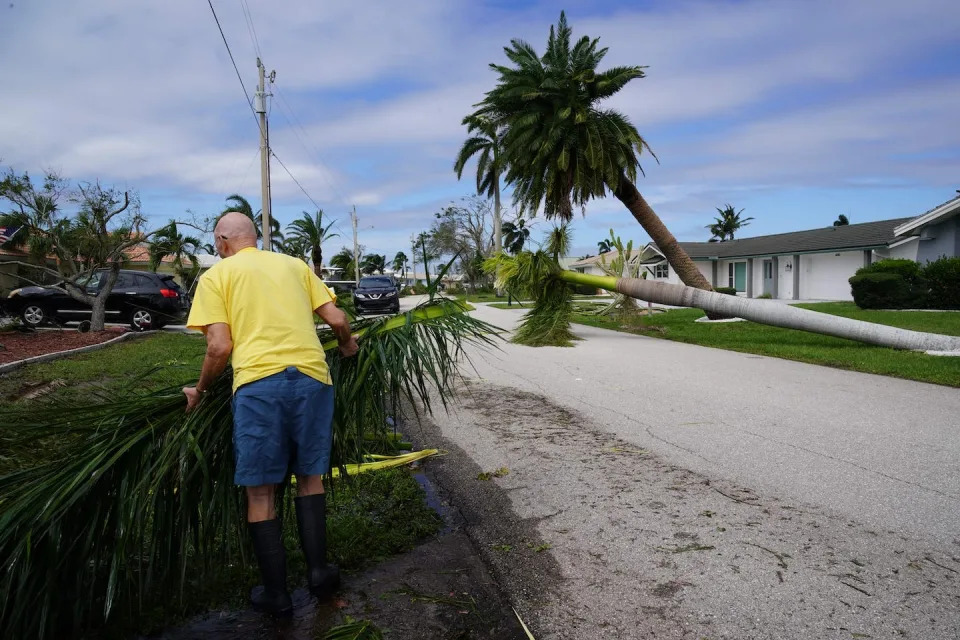
Dozens of homes were left unstable in the Daytona Beach area after Hurricane Nicole’s erosion. Joe Raedle/Getty Images
Back-to-back hurricanes left an unnerving scene on the Florida coast in November 2022: Several houses, and even swimming pools, were left dangling over the ocean as waves eroded the earth beneath them. Dozens of homes and condo buildings in the Daytona Beach area were deemed unsafe.
The destruction has raised a disturbing question: How much property along the rest of the Florida coast is at risk of collapse, and can it be saved?
As the director of iAdapt, the International Center for Adaptation Planning and Design at the University of Florida, I have been studying climate adaptation issues for the last two decades to help answer these questions.
Rising seas, aging buildings
Living by the sea has a strong appeal in Florida – beautiful beaches, ocean views, and often pleasant breezes. However, there are also risks, and they are exacerbated by climate change.
Sea level is forecast to rise on average 10 to 14 inches (25-35 cm) on the U.S. East Coast over the next 30 years, and 14 to 18 inches (35-45 cm) on the Gulf Coast, as the planet warms. Rising temperatures are also increasing the intensity of hurricanes.
With higher seas and larger storm surges, ocean waves more easily erode beaches, weaken sea walls, and submerge cement foundations in corrosive salt water. Together with subsidence, or sinking land, they make coastal living riskier.
The risk of erosion varies depending on the soil, geology and natural shoreline changes. But it is widespread in U.S. coastal areas, particularly Florida. Maps produced by engineers at the Florida Department of Environmental Protection show most of Florida’s coast faces critical erosion risk.
Aging or poorly maintained buildings and sea walls, and older or poor construction methods and materials, can dramatically aggravate the risk.
Designing better building codes
So, what can be done to minimize the damage?
The first step is to build sturdier buildings and fortify existing ones according to advanced building codes.
Building codes change over time as risks rise and construction techniques and materials improve. For example, design criteria in the Florida Building Code for South Florida changed from requiring some new buildings to be able to withstand 146 mph sustained winds in 2002 to 195 mph winds in 2021, meaning a powerful Category 5 hurricane.
The town of Punta Gorda, near where Hurricane Ian made landfall in October 2022, showed how homes constructed to the latest building codes have a much better chance of survival.
Many of Punta Gorda’s buildings has been rebuilt after Hurricane Charley in 2004, shortly after the state updated the Florida Building Code. When Ian hit, they survived with less damage than those in neighboring towns. The updated code had required new construction to be able to withstand hurricane-force winds, including having shutters or impact-resistant window glass.
Many homes in Punta Gorda fared better in Hurricane Ian’s winds because they had been rebuilt to higher standards after Hurricane Charley in 2002. Bryan R. Smith / AFP
However, even homes built to the latest codes can be vulnerable, because the codes don’t adequately address the environment that buildings sit on. A modern building in a low-lying coastal area could face damage in the future as sea level rises and the shoreline erodes, even if it meets the current flood zone elevation standards.
This is the problem coastal residents faced during Hurricanes Nicole and Ian. Flooding and erosion, exacerbated by sea-level rise, caused the most damage – not wind.
The dozens of beach houses and condo buildings that became unstable or collapsed in Volusia County during Hurricane Nicole might have seemed fine originally. But as the climate changes, the coastal environment changes, too, and one hurricane could render the building vulnerable. Hurricane Ian damaged sea walls in Volusia County, and some couldn’t be repaired before Nicole struck.
How to minimize the risk
The damage in the Daytona area in 2022 and the deadly collapse a year earlier of a condo tower in Surfside should be a wake-up call for all coastal communities.
Data and tools can show where coastal areas are most vulnerable. What is lacking are policies and enforcement.
Florida recently began requiring that state-financed constructors conduct a sea-level impact study before starting construction of a coastal structure. I believe it’s time to apply this new rule to any new construction, regardless of the funding source.
With Hurricane Nicole’s storm surge coinciding with high tide, the waves breached a condo tower’s sea walls in Daytona Beach in November 2022. Joe Raedle/Getty Images
A comprehensive sea-level impact study requirement should also allow for risk-based enforcement, including barring construction in high-risk areas.
Similarly, vulnerability audits – particularly for multistory buildings built before 2002 – can check the integrity of an existing structure and help spot new environmental risks from sea-level rise and beach erosion. Before 2002, the building standard was low and enforcement was lacking, so many of the materials and the structures used in those buildings aren’t up to the standards of today.
What property owners can do
There is a range of techniques homeowners can use to fortify homes from flood risks.
In some places, that may mean elevating the house or improving the lot grading so surface water runs away from the building. Installing a sump pump and remodeling with storm-resistant building materials can help.
FEMA suggests other measures to protect against coastal erosion, such as replenishing beach sand, strengthening sea walls and anchoring the home. Engineering can help communities, temporarily at least, through sea walls, ponds and increased drainage. But in the long term, communities will have to assess the vulnerability of coastal areas. Sometimes the answer is to relocate.
However, there’s a disturbing trend after hurricanes, and we’re seeing it with Ian: Many damaged areas see lots of money pouring in to rebuild in the same vulnerable locations. An important question communities should be asking is, if these are already in high-risk areas, why rebuild in the same place?
Hundreds of Arizona Households Set to Be Without Water by End of Year
Lauren Leffer – November 22, 2022
In every month of 2022, Lake Mead’s water level has been the lowest recorded for the time of year since the reservoir was first filled.
More than 500 households in the rural Arizona desert are set to be without running water starting January, 1 2023, as first reported by NBC News. The homes, located in Rio Verde Foothills—an affluent, unincorporated community in the state’s Maricopa County, were built without complying to Arizona’s usual 100-year water supply requirement. Rio Verde Foothills doesn’t have its own water system. Instead, people living in the arid locale rely on private wells or water trucked up from the nearby city of Scottsdale.
However, in response to the ongoing and worsening megadrought, Scottsdale declared late last year that it would cease hauling water to communities outside the city limits on Jan 1, 2023 and encouraged Rio Verde Foothills to find an alternative. Now, with the set deadline fast approaching, residents haven’t found a solution.
At the end of August, Maricopa County rejected a proposal from 550 Rio Verde residents hoping to form their own Domestic Water Improvement District. And though proposed deals have continued to be discussed behind closed doors, Scottsdale Progress reported, no firm decisions have been made and no community-wide fixes are underway.
Under Arizona’s Assured Water Supply Program, housing developments in the state are supposed to have a guaranteed century’s worth of water supply to be approved for construction. But via a semantic loophole, the around 2,200 houses in Rio Verde Foothills were able to skirt that law and be built without a clear long-term water source. Now, even many of the households that once had working wells are running dry.
Scottsdale has been warning for nearly a decade that its water-trucking operation was only ever meant to be a temporary remedy, not a permanent resolution, according to NBC News. And federal pressure amid the ongoing drought has forced the city to try to reduce its water usage.
Last year, when Scottsdale first said it would cease water hauling by January 2023, the U.S. Bureau of Reclamation had declared a Tier 1 water shortage on the Colorado River—reducing the amount of water Southwestern states can get from the river. In August of this year, the Reclamation Bureau upped the shortage designation to Tier 2a.
Scottsdale gets 65% of its water from the Colorado River, and ending its practice of exporting water beyond the city was intended to help Scottsdale lower its total consumption. In addition to cracking down on Rio Verde Foothills, the city has been encouraging its residents to voluntarily lower their usage. And though residents have made some progress and Scottsdale met its initial water reduction goals, the drought persists.
Lake Mead is at its lowest November water level on record since the reservoir was first filled. In fact, in every month of 2022, Lake Mead has been at record low for that time of year. Some seasonal fluctuations are to be expected, but this year’s monsoon season wasn’t nearly enough to make up the deficit. And climate change may be helping to propel already-arid U.S. regions into a permanent state of drought. One study published earlier this year found that 42% of the Southwest’s current drought is attributable to human-caused climate change.
Rio Verde Foothills is yet more evidence that when poor planning and the climate crisis come together, the result is often disastrous.
What Will Russia Without Putin Look Like? Maybe This.
Guest Essay By Joy Neumeyer – November 21, 2022
Ms. Neumeyer is a journalist and historian of Russia and Eastern Europe.
Credit…Nanna Heitmann for The New York Times
Russia’s current condition — militarized, isolated, corrupt, dominated by the security services and hemorrhaging talent as hundreds of thousands flee abroad to escape service in a horrific war — is bleak.
In hopes of an end to this grim reality, some wait expectantly for Vladimir Putin to leave office. To change the country, however, it is not enough for Mr. Putin to die or step down. Russia’s future leaders must dismantle and transform the structures over which he has presided for more than two decades. The challenge, to say the least, is daunting. But a group of politicians is devising a plan to meet it.
Composed of well-known opposition figures as well as younger representatives from local and regional governments, the First Congress of People’s Deputies of Russia met in Poland in early November. The location, Jablonna Palace outside Warsaw, was symbolic: It was the site of early negotiations in the round-table talks that led to the end of Communist rule in Poland. There, over three days of intense debate, participants laid out proposals for rebuilding their country. Taken together, they amount to a serious effort to imagine Russia without Mr. Putin.
The first and most pressing priority, of course, is the invasion of Ukraine. Everyone at the congress opposes the war, which they assume will be lost or lead to nuclear disaster. To deal with the consequences and to prevent a repeat tragedy, they propose an “act on peace” that would demobilize the army and end the occupation of Ukrainian territory, including Crimea; create a joint group for the investigation of war crimes; pay reparations for damaged infrastructure and the families of the dead; and reject future “wars of conquest.” In addition to offering a deterrent to future expansionism, this wide-ranging pledge would provide an essential reckoning with Russia’s history of imperialist invasion.
The officials responsible for the devastation will need to be rooted out, too — something that never happened after the collapse of the Soviet Union. The Congress would bar from working in state and educational institutions those who belonged to “criminal” organizations — such as the Federal Security Services or state television channels — or publicly supported the war, as well as restricting their voting rights. It would also create a “de-Putinization” commission to consider the rehabilitation of certain groups, including those who publicly recant and did not commit especially serious crimes, and open the archives of the security services.
Then there’s the structure of Russia itself. The Russian Federation is highly centralized, with a patchwork of over 80 republics and regions that are strongly subordinate to the president, enabling the accumulation of enormous power. The Congress, drawing on decentralized visions from around the time of the Soviet collapse, proposes to dissolve the Russian Federation and replace it with a new parliamentary democracy. According to a broadly worded draft provision on “self-determination,” the future Russian state should be “joined on the basis of free choice by the peoples who populate it.”
This break with the present could correct the failed promises of the past. From Vladimir Lenin to Boris Yeltsin, modern Russian leaders have a history of offering decentralization to win support and then reneging once they consolidate power. Though all federal subjects are legally equal under Russia’s current Constitution, substantial inequalities persist — a fact that has been highlighted by the disproportionate deployment and death of ethnic minorities from poorer republics like Dagestan and Buryatia in the war in Ukraine.
Revisiting the issue of greater sovereignty could allow the breakaway republic of Chechnya, for example, to leave Russia after its brutal subjugation by Mr. Putin, while enabling regions and republics without strong secessionist movements to renegotiate the allocation of resources and balance of power with the center. It would create a fairer country while undermining Russian nationalism.
The congress is vaguest on its economic plans. One act promises to “review the results of privatization” carried out during the 1990s (which led to the rise of Russia’s oligarchs), while another aims to cancel Mr. Putin’s highly unpopular pension reform of 2020. Missing, however, is a commitment to a strong social safety net or any discussion of transitioning Russia’s economy away from its dependence on energy exports. This is a major oversight. Since the 1990s, when privatization and free elections were introduced simultaneously, wealth and power have been intertwined. Political and economic reform cannot be viewed in isolation from each other.
That’s not the only hitch. The congress’s main organizer and sponsor is Ilya Ponomarev, a leftist tech entrepreneur. The only member of the Russian parliament to vote against the annexation of Crimea in 2014, he left the country, obtained Ukrainian citizenship and now runs a Russian-language news channel in Kyiv. A controversial figure in opposition circles, in August he endorsed the assassination of Daria Dugina, the daughter of the Eurasianist philosopher Alexander Dugin, and asserted it was the work of a secret partisan army inside Russia. This uncorroborated claim outraged fellow opposition figures. Mr. Ponomarev was subsequently disinvited from an event organized by the longtime Kremlin critics Garry Kasparov and Mikhail Khodorkovsky.
Despite their disagreements, Russia’s opposition has a loosely converging vision for the future. Mr. Khodorkovsky and Aleksei Navalny, the country’s most well-known dissident, who is currently languishing in a penal colony, have also issued calls to turn Russia into a parliamentary democracy with more power devolved to the local and regional levels. But associates of Mr. Navalny did not attend the congress, nor did Mr. Kasparov or Mr. Khodorkovsky. Its legitimacy — already challenged by a number of Russian antiwar organizations that said it does not represent them — was also questioned by some participants, several of whom left in protest over what they saw as a lack of equality and transparency in how it was being run.
Such feuding doesn’t help the proposals, which can seem far-fetched. Yet history shows that radical developments are often incubated abroad or underground. In the late 19th and early 20th centuries, political émigrés in bickering communities around Europe plotted the downfall of the Russian empire. Among them was Vladimir Lenin, who was living in Poland at the outbreak of World War I.
For now, with most of Russia’s population forced into quiescence while others lose their jobs or freedom for expressing dissent, the possibility of the country’s transformation appears remote. Change, however, can come when it’s least expected. In early 1917, a pessimistic Lenin lamented that he probably wouldn’t live to see the revolution; a few weeks later, the czar was overthrown.
Russia is no more doomed to repeat the past than any other country. The time to reimagine its future is now.
A Soil Fungus That Causes Lung Infections Is Spreading Across the U.S.
Nikki Main – November 21, 2022
The fungus histoplasma, which causes lung infections, was concentrated in the Midwest in the 1950s and 60s (top map), but now causes significant disease throughout much of the country (bottom).
An illness-causing fungus known as hisoplasma is in the soil of nearly all U.S. states, a new study suggests. The researchers behind the work say doctors may be relying on outdated risk maps and therefore missing diagnoses of the infections, which can sometimes be deadly.
According to the CDC, histoplasma, or histo, is found in the soil of central and eastern U.S. states, primarily in Ohio and the Mississippi River valleys. But that assumption is based on research from the 1950s and 1960s, says the team behind a new paper published in Clinical Infectious Diseases. When a person breathes in spores of the fungus, they can contract an infection called histoplasmosis.
“Every few weeks I get a call from a doctor in the Boston area – a different doctor every time – about a case they can’t solve,” said study author Andrej Spec, an associate professor of medicine at Washington University in St. Louis, in a press release. “They always start by saying, ‘We don’t have histo here, but it really kind of looks like histo.’ I say, ‘You guys call me all the time about this. You do have histo.’”
Lead author Patrick B. Mazi, a clinical fellow in infectious diseases also at Washington University in St. Louis, and his colleagues analyzed more than 45 million Medicare fee-for-service beneficiaries extending from 2007 through 2016. They looked at diagnoses across the country of three fungal diseases: histoplasmosis, coccidioidomycosis, and blastomycosis. Histo, the most common, was causing clinically relevant rates of illness in at least one county in 48 of 50 states, as well as Washington, D.C. The other two infections were each found in more than half of states.
“Fungal infections are much more common than people realize, and they’re spreading,” Spec said in the release. “The scientific community has underinvested in studying and developing treatments for fungal infections. I think that’s beginning to change, but slowly.” Climate change may be driving this spread as warming temperatures make more habitats suitable for the fungi.
While histo can be easily combatted in healthy adults, and many people who are exposed never develop symptoms, those who are immunocompromised as well as infants and people 55 years and older may develop more serious illness, including a cough, fever, chest, pain, body aches, and fatigue, according to the CDC. Symptoms appear within three to 17 days after exposure; most symptoms will go away within a month, but if it spreads from a person’s lungs, the illness can become severe and require months of treatment.
People can be exposed to histo and other fungal pathogens through activities that disrupt soil, like farming, landscaping, and construction. They can also be exposed inside caves and while working in basements and attics. Spec noted: “It’s important for the medical community to realize these fungi are essentially everywhere these days and that we need to take them seriously and include them in considering diagnoses.”
Large part of Ukranian corn crop may stay in fields over winter.
November 21, 2022
KYIV, Nov 20 (Reuters) – Significant areas of Ukraine’s corn crop may be left to overwinter in the fields due to difficulties with harvesting and fuel shortages, analyst APK-Inform said on Sunday.
Corn can potentially be harvested in winter or early spring, but previously only very small areas of the crop would be left to overwinter if farmers wanted to reduce grain moisture.
Ukraine is a major global corn grower and exporter and harvested almost 42 million tonnes in 2021. This year, analysts say, the harvest could total 27.5 million to 27.9 million tonnes.
APK-Inform said in a report that the prospect for a large part of the corn crop to stay in fields this winter was “becoming more and more possible” due to low domestic prices, difficulties with field work caused by the war and high fuel prices.
The Ukrainian agriculture ministry said on Friday only 50% of the area sown for corn had been harvested as of Nov. 17, or 12.3 million tonnes.
The government has said Ukraine could harvest between 50 million and 52 million tonnes of grain this year, down from a record 86 million tonnes in 2021, because of the loss of land to Russian forces and lower yields.
Farmers have already completed the 2022 wheat and barley harvests, threshing 19.4 million and 5.6 million tons respectively. (Reporting by Pavel Polityuk; Editing by Kirsten Donovan)
Finding safe haven in the climate change future: The Great Plains
David Knowles, Senior Editor – November 19, 2022
This Yahoo News series analyzes different regions around the country in terms of climate change risks that they face now and will experience in the years to come.
As the negative consequences of rising global temperatures due to humankind’s relentless burning of fossil fuels become more and more apparent in communities across the United States, anxiety over finding a place to live safe from the ravages of climate change has also been on the rise.
“Millions and likely tens of millions of Americans” will move because of climate through the end of the century, Jesse Keenan, an associate professor of real estate at Tulane University’s School of Architecture, told Yahoo News.“People move because of school districts, affordability, job opportunities. There are a lot of drivers, and I think it’s probably best to think about this as ‘climate is now one of those drivers.’”
The Buffalo Bayou in Houston. (Brandon Bell/Getty Images)
In late October, a report by the United Nations concluded that average global temperatures are on track to warm by 2.1°C to 2.9°C by the year 2100. As a result, the world can expect a dramatic rise in chaotic, extreme weather events. In fact, that increase is already happening. In the 1980s, the U.S. was hit with a weather disaster totaling $1 billion in damages once every four months on average. Thanks to steadily rising temperatures, they now occur every three weeks, according to a draft report of the latest National Climate Assessment, and they aren’t limited to any particular geographical region.
To be sure, calculating climate risk depends on a dizzying number of factors, including luck, latitude, elevation, the upkeep of infrastructure, long-term climate patterns, the predictable behavior of the jet stream and how warming ocean waters will impact the frequency of El Niño-La Niña cycles.
“No place is immune from climate change impacts, certainly in the continental United States, and throughout the U.S. those impacts will be quite severe,” Keenan said. “They will be more severe in some places and less severe in other places. Certain places will be more moderate in terms of temperature and some places will be more extreme, but we all share the risk of the increase of extreme events.”
In this installment, we look at the low-lying, expansive, north-south strip of states in the center of the country.
The Great Plains
A vast, predominantly flat stretch in the center of the country that extends from the Canadian border to the Gulf of Mexico, the Great Plains includesMontana, Wyoming, North Dakota, South Dakota, Nebraska, Kansas, Oklahoma and Texas.
While the large overall area of the Great Plains translates into markedly different weather — with North Dakota enduring frigid winters and states like Oklahoma and Texas baking in the summer months — the region has been warming quickly in recent years.
North Dakota, where the average annual temperature is 41.1°F, has warmed by an average of 2.6°F since the turn of the 20th century, according to data provided by the National Oceanic and Atmospheric Administration. Texas, where the average temperature is 65.8°F, has warmed by 1.5°F on average over that same period.
The bulk of that warming, we know, has occurred in recent decades because higher concentrations of greenhouse gases in the atmosphere have further amplified the greenhouse effect, speeding up the rate of temperature rise. Short of a technological breakthrough, unless concerted action is taken to stop burning fossil fuels to slow emissions, scientists say, the world will keep getting hotter.
Tumbleweed rolls across a dried-out landscape in central California’s Kern County. (Frederic J. Brown/AFP via Getty Images)
“The average annual Texas surface temperature in 2036 is expected to be 3.0°F warmer than the 1950-1999 average and 1.8°F warmer than the 1991-2020 average,” a 2021 report from the Texas state climatologist found. “The number of 100-degree days at typical stations is expected to nearly double by 2036 compared to 2001-2020, with a higher frequency of 100-degree days in urban areas.”
Texas, in fact, is home to all of the Great Plains’ top 10 worst-rated counties — Cameron, Galveston, Willacy, Kleberg, Refugio, Nueces, Pecos, Starr, Webb and Harris — in terms of overall climate change risks, according to information provided by data analytics firm the Rhodium Group and a 2020 analysis of counties in the lower 48 states published by ProPublica and the New York Times. And dozens of other Texas counties aren’t far behind on that list.
In no small part that’s because of two factors, the state’s latitude and its proximity to the Gulf of Mexico. The Rhodium rankings were based on six categories related to climate change: heat stress, the combination of heat and humidity (wet bulb), crop loss, sea level rise, very large fires and overall likely economic damages.
North Dakota’s Ward, Renville, Mountrail and Bottineau counties took the top four spots when it came to safest locations in the Great Plains for climate change risk, with the state also placing two more in the top 10 — Williams and Walsh counties. Montana’s Silver Bow, Glacier and Deer Lodge counties rated No. 5-No. 7 on that list, with Wyoming’s Uinta County ranking eighth-safest in the region.
Colter Bay Marina in Grand Teton National Park in Wyoming was closed for the summer due to the low water levels of Jackson Lake, seen here in August. (Amber Baesler/AP)
Summertime temperatures this year proved brutal for many states in the southern Great Plains, and drought conditions continued to worsen across the entire region.
On July 19, Oklahoma City set a new temperature record for that day, hitting 110°F during a heat wave that locked in triple-digit heat for more than a week. Yet all-time records, many of which were set in 1936 during the Dust Bowl years, were not surpassed.
Many climate deniers point to record high temperatures during the Dust Bowl years, which were amplified by poor farming practices, to try to show that global warming isn’t happening. If the records were set in the 1930s, the reasoning goes, then, by definition, the world is not warming.
That leaves out the fact that climate anomalies have continued to occur since humankind began pumping greenhouse gases into the atmosphere, that the incidence of heat waves is increasing and that the country on average continues to experience fewer days of extreme cold. In Houston, for example, five of the six hottest Julys on record have occurred since 2009, while the city’s top 10 coolest Julys all happened before 1980, according to data from the National Weather Service.
Skeptics who argue that humankind cannot influence something as large as the Earth’s climate also fail to address the impact that discarding harmful farming practices has had in preventing the return of Dust Bowl conditions. Yet rising temperatures and the continued depletion of the aquifers that help irrigate the Great Plains threaten that progress.
A sprinkler near Dodge City, Kan., in 2012. (Kevin Murphy/Reuters)
“Right now we are seeing more dust storms as this drought worsens in what was formerly the Dust Bowl region,” UCLA climate scientist Daniel Swain, who also consults for ClimateCheck, a company that provides climate change risk assessments on real estate nationwide, told Yahoo News. “Certainly nothing on the order of what we saw in the 1930s, but there is a severe, worsening drought there and there are some self-fulfilling feedback mechanisms whereby things start to get warm and dry, they dry out the soil, which begets more warmth and more dryness.”
As in other parts of the country, rising average temperatures in the Great Plains are wreaking havoc on the water cycle, specifically when it comes to sustaining water levels in the High Plains Aquifer. In the years to come, that could pose significant issues in the delivery of water for agriculture.
“In the northern portion of the Great Plains, rain can recharge the aquifer quickly. However, with climate change, precipitation in the winter and spring is projected to increasingly fall in the form of very heavy precipitation events, which can increase flooding and runoff that reduce water quality and cause soil erosion,” the EPA says on its website. “In the southern portion of the region, little recharge occurs, so declines in the aquifer’s water level are much greater. Climate change will worsen this situation by causing drier conditions and increasing the need for irrigation.”
While it is not entirely clear how climate change will impact precipitation trends across all of the Great Plains in the coming decades, there are warning signs in states like Montana, where the melting winter snowpack helps supply the region with water.
A serious drought has made it difficult to tell the difference between the prairie and the dirt road on the Cheyenne River Reservation near Dupree, S.D. (Jonathan Ernst/Reuters)
“Higher spring temperatures will also result in earlier melting of the snowpack, further decreasing water availability during the summer months,” the EPA says on its website.
More and more often, when it does rain across the Great Plains, it pours. Soil erosion, in turn, can set back the progress made to avert future Dust Bowls, and as evaporation rates rise in tandem with warmer temperatures, the threat of wildfires is also growing. Former Kansas State climatologist Mary Knapp has long warned that while agricultural advances have kept a 1930s disaster from recurring, climate change could yet plunge the Great Plains back into the danger zone.
“I’ve been saying that for years,” Knapp told the Mercury newspaper in Manhattan, Kan., in 2021. “The thought is, with modern agricultural and conservation techniques, that we would preclude the scenario that plagued the Dust Bowl, but there are other factors that can remove vegetation.”
Perhaps the surest climate change bet for the Great Plains is that warmer average temperatures will play out differently across a large region already accustomed to dramatic weather fluctuations. Some parts will have to deal with an uptick in what is known as the “wet bulb” effect, the potentially fatal combination of hot temperatures and high humidity that conspire to prevent the body from being able to cool itself down through the evaporation of sweat. That metric was one of the factors that explains why a place like Galveston County in Texas rated so poorly on the Rhodium analysis.
A heat advisory was issued in Dallas in July due to scorching weather. (Shelby Tauber/Reuters)
But climate change has also already disrupted the water cycle in other dangerous ways.
“In late August 2017, Hurricane Harvey ravaged the Houston area with 1 trillion gallons of rain, enough to run Niagara Falls for 15 days. No other big American city has withstood such a natural disaster in modern times,” Houston Mayor Sylvester Turner wrote in the introduction to the city’s 2020 plan on how to use billions in taxpayer funds to harden the city against the changing climate.
Harvey, which racked up $125 billion in damages and killed 107 people, and 2019’s Tropical Storm Imelda, which resulted in another $5 billion in damages and killed six, were both slow-moving systems that unloaded massive amounts of rain from an oversaturated atmosphere. In close succession, they shined a light on Houston’s vulnerability to flooding, but that’s not the only risk the city faces from rising global temperatures.
“Hurricanes, tropical storms, and flooding are not the only threats that we face. Houston is hot — and our heat is increasing due to climate change and the urban heat island effect,” Turner wrote.
Even though studies have shown that climate change is making tropical cyclones wetter, windier, slower and able to ramp up quicker than in a pre-climate-change world, persuading residents and elected officials to prepare for those risks is easier after they’ve witnessed the impacts firsthand.
People make their way down flooded Telephone Road in Houston in August 2017 in the wake of Tropical Storm Harvey. (Thomas Shea/AFP via Getty Images)
“If, for a location, the policy becomes [investing in] sea walls and sewage and drainage and stronger construction, better infrastructure and so forth, then places may be forecast to retain value and people may stay,” Parag Khanna, the founder and CEO of Climate Alpha, a company that helps investors quantify climate change risks to real estate, told Yahoo News.
“You can’t on the one hand continue to have the American dream rest on your property values going up, and on the other hand have people increasingly in survival society, being forced to rebuild time and again after disasters. Those two things are not compatible,” he added.
To be sure, hardening infrastructure from the daunting number of threats posed by climate change is quite expensive, but a reluctance to prepare can prove to be even more so.
In February 2021, a polar vortex descended on Texas, a state that years earlier had moved to deregulate its energy sector. The surging demand for electricity left more than 4.5 million homes and businesses without power. The storm essentially brought North Dakota-like winter conditions to the Lone Star State for days on end, resulting in the deaths of more than 170 people and more than $20 billion in damages, costing the state’s economy between $80 billion and $130 billion, according to the Dallas Federal Reserve.
As counterintuitive as it may sound, studies have since linked the severe winter outbreak to climate change. Thanks to the fact that the Arctic is warming faster than any other region on Earth, those higher temperatures have been shown to disrupt the behavior of polar vortexes, weakening them so that they wander south over the continental U.S.
That’s exactly what happened this week, when another high pressure ridge in Alaska sent another wave of cold arctic air over much of the country.
While the big picture is that the last eight years have been the warmest in recorded history, that warming will usher in an era of what scientists call “climate chaos,” in which a variety of new risks will present themselves. So, while states like Oklahoma and Texas have begun rolling out plans to help them endure hotter temperatures born of climate change, they also face a choice about how much to spend to winterize the electrical grid. Estimates for upgrading it so as to withstand a future polar vortex are anywhere between $5 billion and $20 billion, Texas Monthly reported.
West Texas earthquake causes damage hundreds of miles away
November 18, 2022
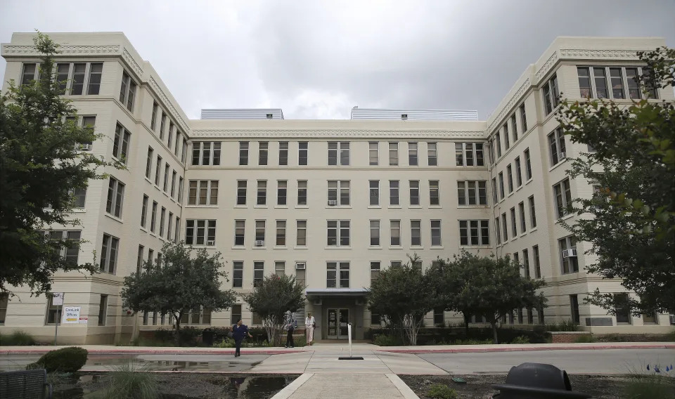
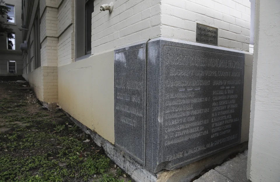
This May 24, 2021 photo shows the Robert B. Green hospital building, Bexar county’s original hospital that has been standing for more than 100 years, in San Antonio. A strong earthquake that struck a remote area of the West Texas desert on Wednesday, Nov. 16, 2022, caused damage in San Antonio, hundreds of miles from the epicenter, officials said. University Health said Thursday, Nov. 17, that the historical building was deemed unsafe because of damage sustained from the quake. (Kin Man Hui/The San Antonio Express-News via AP)This May 24, 2021 photo shows a historical marker on the corner of the old Robert B. Green Hospital building, Bexar county’s original hospital that has been standing for more than 100 years, in San Antonio. A strong earthquake that struck a remote area of the West Texas desert on Wednesday, Nov. 16, 2022, caused damage in San Antonio, hundreds of miles from the epicenter, officials said. University Health said Thursday, Nov. 17, that the historical building was deemed unsafe because of damage sustained from the quake. (Kin Man Hui/The San Antonio Express-News via AP) ASSOCIATED PRESS
University Health said Thursday that its Robert B. Green historical building was deemed unsafe because of damage sustained from the quake, which hit Wednesday in a remote area near the New Mexico border. The historical building is more than 100 years old and has been closed off for safety reasons, University Health said.
The quake initially had a 5.3 magnitude but that was revised upward to 5.4. The earthquake’s epicenter was about 23 miles (37 kilometers) south of Mentone, a tiny community about 350 miles (560 kilometers) northwest of San Antonio.
It was one of the strongest earthquakes on record in Texas and hit in an area known for oil and gas production. On Thursday, the state’s Railroad Commission — which regulates Texas’ oil and gas industry — sent inspectors to the site to determine whether any actions were needed.
Earthquakes in the south-central United States have been linked to oil and gas production, particularly the underground injection of wastewater. The U.S. Geological Survey said research suggests that a 5.0 magnitude quake that struck the same West Texas area in 2020 was the result of a large increase of wastewater injection in the region.
In neighboring Oklahoma, thousands of earthquakes of varying magnitudes have been recorded in the past decade, leading state regulators to direct producers to close some injection wells.
Red tide update: State report shows toxic algae levels from Sarasota south to Marco Island
Chad Gillis, Fort Myers News-Press – November 17, 2022
Scientists are saying a red tide bloom that’s lingered along the coast for a few weeks is now being fed by nutrients running off the landscape in the wake of Hurricane Ian.
Red tide (Karenia brevis) is a naturally occurring organism in the Gulf of Mexico that sometimes blooms to toxic levels.
But research shows that nutrients from farm fields, lawns and septic tanks fuel red tide blooms close to shore — making them more frequent, longer-lasting and more intense.
“I don’t see any good evidence that hurricanes initiate a red tide, but once you have a red tide started, runoff will make it worse,” said Larry Brand, a water quality expert, scientist and professor at the University of Miami.
Ian didn’t create the conditions for the original bloom; but rain water and storm surge has helped fuel the bloom, which now stretches from the Sarasota area south to Marco Island.
Counts of 1 million cells per liter and higher have been reported at multiple locations along the Southwest Florida coast.
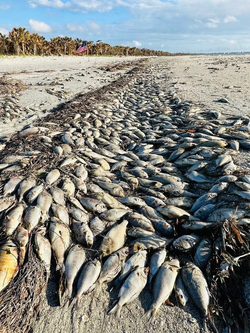
Dead fish litter many beaches in the region, and the Florida Department of Health in Collier County issued an exposure advisory Wednesday.
DOH agrees with Brand, that nutrients flowing off the landscape contribute to the intensity and duration of the bloom.
Thousands of dead fish line the high tide line at Cayo Costa State Park on Nov. 14, 2022. Red tide has moved into Lee County waters in recent weeks.
“Once inshore, these opportunistic organisms can use nearshore nutrient sources to fuel their growth,” a Wednesday DOH press release reads. “Blooms typically last into winter or spring, but in some cases, can endure for more than one year.”
What should Southwest Florida residents do?
DOH says people who live along the coast should even check their air conditioning filters.
“Residents living in beach areas are advised to close windows and run the air conditioner, making sure that the A/C filter is maintained according to manufacturer’s specifications,” DOH says. “If outdoors near an affected location, residents may choose to wear masks, especially if onshore winds are blowing.”
Carly Jones, spokeswoman for the Florida Fish and Wildlife Conservation Commission — the state agency charged with monitoring red tide, said offshore winds can help push the contaminated waters and the microscopic algae away from the coast.
The latest FWC report show the strongest red tide counts have been found in northern Lee and Sarasota counties.
“Some people experience respiratory irritation (coughing, sneezing, tearing and an itchy throat) when the red tide organism is present and winds blow onshore,” Jones wrote in an email to The News-Press. “Offshore winds usually keep respiratory effects experienced by those on the shore to a minimum. The Florida Department of Health advises people with severe or chronic respiratory conditions, such as emphysema or asthma, to avoid red tide areas.”
Red tide can contaminate shellfish, and the DOH recommends against collecting and eating shellfish from this region at this time.
Locally caught, properly cleaned and cooked fish can be eaten, the press release says.
DOH recommends washing yourself and all clothing if you make contact with waters containing the toxic algae.
Hurricane Irma also stirred nutrients in toxic algae bloom in 2017
Calusa Waterkeeper John Cassani has been monitoring the bloom online.
“I’m hearing people aren’t seeing as many gamefish species as compared to (Hurricane) Irma (2017),” Cassani said. “It’s mostly foraging fish but most are decayed to the point you can’t determine the species.”
Hurricane Irma stirred up nutrients in the Lake Okeechobee/Caloosahatchee River system five years ago, and the following summer was virtually lost to a massive red tide and blue-green algae bloom in the river.
Lee County was part of a state of emergency for both blooms.
Some scientists have speculated that Hurricane Ian’s aftermath will cause similar conditions between now and the spring of 2024.
The Hurricane Irma-fed red tide lasted from the fall of 2017 until the spring of 2019.
“It’s a neurotoxin,” Cassani said. “There are neurological symptoms that have been defined in response for red tide. And people with asthma are showing up in emergency rooms. There’s an influx often during a bloom. It’s an unregulated contaminant.”
Red tide worsens and spreads to Tampa Bay. Dead fish found on Anna Maria Island
Ryan Ballogg – November 16, 2022
A red tide bloom has worsened in Southwest Florida waters this week, the latest samples from the state show.
The algae that causes red tide, Karenia brevis, was observed at elevated levels in Tampa Bay, around Anna Maria Island, Longboat Key and in Sarasota Bay. Dead fish and breathing irritation have been reported on local beaches.
The bloom remains most intense further south offshore of Sarasota, Charlotte and Lee counties, according to samples from the Florida Fish and Wildlife Conservation commission.
On Monday, a very low concentration of red tide algae was detected in a water sample near the Rod and Reel Pier in Anna Maria —down from medium levels last week— and a medium concentration was again found in waters near Longboat Pass in Bradenton Beach.
University of South Florida’s red tide for predicts that very low levels of the algae will continue to circulate around Anna Maria Island through this weekend. At very low levels, respiratory irritation is possible.
USF predicts that low to medium levels of the algae will circulate around Longboat Key, with high levels persisting farther south in Sarasota Bay.
At levels of medium and above, which are considered “bloom concentrations” of the algae, respiratory irritation and fish kills are likely.
Slight breathing irritation and a few dead fish were reported on Anna Maria Island beaches this week, Mote Marine Laboratory’s red tide beach conditions report said. To the south, moderate breathing irritation and numerous dead fish were observed on several Sarasota County beaches.
Red tide’s patchy nature means that even beaches in close proximity can have very different conditions. Respiratory irritation and dead fish can also become more or less present as wind directions and tides change.
The National Oceanic and Atmospheric Administration forecasts the respiratory threat from red tide. On Wednesday, NOAA warned that beachgoers in Manatee, Sarasota, Charlotte, Lee and Collier counties could experience moderate to high levels of respiratory irritation over the next 36 hours.
On Monday, the Florida Department of Health Manatee County issued a red tide health alert for the following beaches:
Bayfront Park
Coquina Beach South
Longboat Pass/Coquina Boat Ramp
Rod and Reel Pier (City of Anna Maria Island)
FDOH-Manatee offers the following red tide safety tips:
Look for informational signage posted at most beaches.
Stay away from the water.
Do not swim in waters with dead fish.
Those with chronic respiratory problems should be especially cautious and stay away from these locations as red tide can affect your breathing.
Do not harvest or eat molluscan shellfish or distressed or dead fish from these locations. If caught live and healthy, finfish are safe to eat as long as they are filleted and the guts are discarded. Rinse fillets with tap or bottled water.
Wash your skin and clothing with soap and fresh water if you have had recent contact with red tide.
Keep pets and livestock away and out of the water, sea foam and dead sea life. If your pet swims in waters with red tide, wash your pet as soon as possible.
Residents living in beach areas are advised to close windows and run the air conditioner, making sure that the A/C filter is maintained according to manufacturer’s specifications.
If outdoors near an affected location, residents may choose to wear masks, especially if onshore winds are blowing.
Will Florida’s red tide get worse because of Hurricane Nicole? Here’s what experts say
Max Chesnes – November 15, 2022
Red tide was found this week in the waters off Anna Maria Island, and now experts fear Hurricane Nicole could possibly make conditions worse for Tampa Bay.
Extra runoff from rainfall could mean more algal-bloom-fueling nutrients dump into the bay. That may — or may not ― spark more Red Tide.
“Of course our eyes are on any additional rainfall and runoff that might occur in response to . . . Nicole’s passage,” said Ed Sherwood, executive director of the Tampa Bay Estuary Program. “With red tide now present in lower Tampa Bay, additional nutrient loads may exacerbate the bloom if salinities remain high.”
It’s a big if, with plenty of variables. The organism that causes red tide, karenia brevis, prefers salty marine environments. Rainwater is fresh, but brings pollution along with it as it flows into the bay. That pollution, in turn, can fuel red tide blooms.
“Any additional nutrient loads to our coast — especially when a red tide is already present in the estuary — is a concern,” Sherwood wrote in an email. “As the red tide bloom that formed further south is carried by winds and currents into our estuary, any additional stormwater nutrient loads caused by (Nicole) may promote water quality declines this winter.”
State water samplers detected medium concentrations of red tide-causing karenia brevis, between 100,000 and 1,000,000 cells per liter, on the northern tip of Anna Maria Island Monday, according to the latest Florida Fish and Wildlife Conservation Commission data. Scientists consider that level a “bloom,” meaning breathing problems are possible and fish kills are probable.
On Nov. 2, small amounts were measured 11 miles offshore of Tampa Bay, data show.
There’s cause for concern for residents in the Tampa Bay area, “because it is likely that a red tide bloom will evolve here,” according to Bob Weisberg, a physical oceanographer at the University of South Florida. Once Red Tide is measured at the mouth of Tampa Bay, tidal currents could easily bring it into the estuary. Now, add the winds from Nicole into the mix.
Medium concentration levels of Karenia brevis, the algae that causes red tide, were detected in water samples taken Monday by the Florida Fish and Wildlife Conservation Commission near Longboat Pass.
The storm is currently pushing northerly winds, which makes conditions more favorable for the spread of red tide here, according to Weisberg. “Such winds will result in red tide cells located offshore along the bottom being transported toward the shore and hence an increase in what may be observed here in subsequent days.”
Still, the mixing of wind and water during storm events are speculated to hurt red tide, so there may also be a die-off of some karenia brevis cells, Weisberg wrote in an email. Nicole isn’t nearly as strong as the recent Hurricane Ian, though, so there’s a chance that more Red Tide organism feeds on runoff entering the bay versus being killed off in turbulent water.
“Red tide ecology is the whole shebang,” Weisberg wrote.
The most recent models from the University of South Florida’s Ocean Circulation Lab show traces of the red tide organism — resembling green strands of spaghetti on the chart — in small amounts entering into Tampa Bay over the next few days, beginning from where it was first measured on Anna Maria Island.
The takeaway is that there’s no immediate threat of dangerous red tide exposure through the weekend, but it’s definitely something to watch, according to Yonggang Liu, the lab’s director.
The latest Red Tide models from the University of South Florida, which run through Nov. 12, show small concentrations of the Red Tide-causing organism flowing into Tampa Bay over the next few days.
“It may still be OK for Tampa Bay area in the next three days,” Liu wrote in an email. “You may go to a beach and enjoy water activities without issues of red tide.”
With Nicole expected to drop as much as four inches of rain in the area, it’s still to be determined just how much runoff the bay will receive. But storm surge shouldn’t be a major issue for the estuary, according to tide models provided by Liu. Sea level will first recede, but not nearly as much as what was documented with Hurricane Ian earlier this year and Hurricane Irma in 2017.
Once Nicole passes, the bay should hopefully start to see a reprieve, according to Sherwood.
“We’re coming to the tail-end of our rainy season, so with the exception of the recent tropical storms that are impacting our region, we should start to see a decline in storm-water nutrient loads from our coast,” Sherwood said. “That in combination with cooling temperatures will hopefully lead to some water quality improvements over the next several months.”