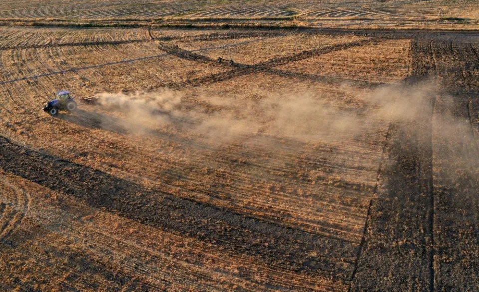
(Bloomberg) — Torrential downpours claimed the lives of more than 1,000 in Pakistan, where almost half a million people are in relief camps. A massive deluge crashed across Mississippi in the past week, leaving the roughly 150,000 residents of capital city Jackson without reliable access to clean drinking water. Cascades of rain recently poured into Seoul’s subway stations and turned streets into rivers in one of the worst storms in more than a century.
The world has been swept by a series of deadly floods in recent weeks, destroying homes, inundating croplands, snarling mining operations and wreaking economic devastation.
In Pakistan alone, officials estimate the damage at more than $10 billion — a toll that was part of what forced the country to secure a $1.1 billion loan from the International Monetary Fund in order to avert an imminent default. The country is now facing a looming food crisis with large swathes of farmland under water. Downpours have hit places as varied as India, the US South and the UK.
In a paradoxical turn, the torrents have come at a time when the planet is also besieged by crippling drought and dwindling rivers. While it seems to defy logic, the mechanics of the atmosphere make it possible for record-shattering floods to occur alongside widespread heat waves and drought. It’s not unknowable chaos, but rather the impact of accelerating climate change.
“As the air and oceans warm under a thicker blanket of greenhouse gases, more water vapor evaporates into the air, providing more moisture to fuel thunderstorms, hurricanes, nor’easters and monsoons,” said Jennifer Francis, a senior scientist at the Woodwell Climate Research Center in Falmouth, Massachusetts.
“Heavier downpours and more frequent flooding are clear fingerprints of the climate crisis,” she said.
How Are Droughts and Floods Connected?
The droughts and floods are connected. That’s partly because when moisture in the air is diverted from one region, it gets dumped somewhere else.
There’s also the lingering La Nina, which also contributes to floods and droughts worldwide. The phenomenon, caused when the equatorial Pacific cools, disrupts weather patterns worldwide. It can bring more rain to Indonesia, inundating palm plantations, while the southern US and California become drier, hurting cotton crops and wine grapes.
Climate change is the biggest driver. Earth’s rising temperatures mean that the warmer atmosphere can hold more water vapor, said Daniel Swain, a climate scientist with the University of California, Los Angeles. Every increase of 1 degree Celsius boosts the capacity by about 7%. The period January-July 2022 was the sixth-warmest start to a calendar year for the globe in records going back 143 years, according to the US National Centers for Environmental Information.
“That increases the ceiling on how intense precipitation can become,” Swain said, adding that the hotter atmosphere also allows more water evaporation.
“That same process also increases the atmosphere’s propensity to act as a giant sponge and extract additional water from the landscape,” Swain said. “This is often less recognized than the effect on increasing extreme precipitation, but it’s still quite important: It largely explains the increased soil-drying effects of climate change and the effect of global warming on drought and wildfire severity.”
Take China’s Sichuan province. Just weeks ago, the area was in the grips of an historic drought that caused major power shortages and disrupted business for companies including Toyota Motor Corp. Now, the southwestern province, one of the country’s most populous, is being hit by floods. More than 119,000 people have been evacuated, and authorities are asking more than 300 mines, including 60 coal operations, to withdraw workers as a safety precaution.
In places like Colorado, where capital city Denver recently saw daily record rainfall, the showers aren’t undoing the deeper impact of the prolonged drought pattern that has gripped the US West. But it can be enough to spark flash floods, cancel flights and put homes, property and life at risk. In New Mexico, about 200 people at a national park were recently trapped for several hours during a downpour.
Other places, including parts of Australia, are seeing a broader shift to a pattern of deluges. At the start of 2022, a relentless stream of storms caused massive flooding across the southeastern part of the continent. In a three-month outlook, Australia’s Bureau of Meteorology predicts more flooding is in store.
“With wet soils, high rivers, and full dams, and the spring outlook for above average rainfall, elevated flood risk remains for eastern Australia,” the bureau said in a statement.
In Pakistan, the extra moisture in the atmosphere gave the annual monsoon more power. That coupled with a rapid melt from regional glaciers “made a bad flood even worse,” said Francis of the Woodwell Climate Research Center.
“Add to that the encroachment of infrastructure and homes into floodplains, and you have a recipe for the flooding disaster that unfolded,” she said.
Many of Pakistan’s rice and vegetable crops have been wiped out. Wheat planting, which starts in October, is also threatened at a time when the world can ill afford another disruption to grain supplies. Even before the floods, the country was facing a wheat shortage.
Of course, flooding has impacted civilization since its start. Since 1980, 36 major floods in the US have caused $173.7 billion in damage across the country, according to the National Centers for Environmental Information. But now the extremes are occurring more frequently, and they’ve grown in power.
“Unless we treat the underlying disease — the blanket of greenhouse gases thickened by burning fossil fuels and slashing forests — events like these will happen more often,” Francis said. Flooding will “intensify, last longer, and affect regions normally immune to them.”
Colorado River would need years of ‘biblical’ precipitation to be restored. The Gaggle plumbs Arizona’s water crisis
Kaely Monahan, Arizona Republic – August 31, 2022
The news reports are morbid. Bodies are being discovered in the newly visible muck of Lake Mead. But perhaps the most terrifying reality about the water situation involving the Colorado River is not the past; it’s the future for all of us. The water is drying up.
In early August, the U.S. Interior Department announced a water shortage that will trigger cuts in the water supply in Arizona and other parts of the Southwest. A United Nations environmental program said Lake Powell and Lake Mead had reached “dangerously low levels.”
The federal Bureau of Reclamation, which oversees the nation’s water projects, gave the seven states and 30 tribes that use the Colorado River eight weeks to come up with a plan to conserve more water.
The goal was to conserve an extra 2 million to 4 million acre-feet of water, thereby stabilizing the rapidly dwindling reservoirs.
However, no plan was reached, and the clock keeps ticking.
Arizona has been fiercely conserving water for some time. But we share the Colorado River with California, Wyoming, Utah, Nevada, Colorado and New Mexico, as well as 30 federally recognized tribes.
This doesn’t take into account Mexico, which also uses the river as a water supply.
In this episode of The Gaggle, host Ron Hansen is joined by The Republic’s Brandon Loomis and Sarah Porter, director of the Kyl Center for Water Policy at ASU. Together they wade through the issues facing our state’s water supply and what government and policy leaders are doing about them.
Listen to the episode:
The best way to listen is to subscribe to The Gaggle on your favorite podcast app, but you also can stream the full episode below.
Do you have questions about Arizona’s political scene? We want to hear from you! Submit your questions to thegaggle@arizonarepublic.com or leave us a voicemail at 602-444-0804. Your question just might end up on a future episode!
A firefighter helicopter drops water to put out a wildfire in the Baixa Limia – Serra do Xures Natural Park near the village of Lobeira, Ourense province, northwestern Spain, on August 25, 2022. Credit – MIGUEL RIOPA- AFP/Getty Images)
While nations rally to reduce their carbon emissions, and try to adapt at-risk places to hotter conditions, there is an elephant in the room: for large portions of the world, local conditions are becoming too extreme and there is no way to adapt. People will have to move to survive.
Over the next fifty years, hotter temperatures combined with more intense humidity are set to make large swathes of the globe lethal to live in. Fleeing the tropics, the coasts, and formerly arable lands, huge populations will need to seek new homes; you will be among them, or you will be receiving them. This migration has already begun—we have all seen the streams of people fleeing drought-hit areas in Latin America, Africa, and Asia where farming and other rural livelihoods have become impossible.
The number of migrants has doubled globally over the past decade, and the issue of what to do about rapidly increasing populations of displaced people will only become greater and more urgent as the planet heats.
We can—and we must—prepare. Developing a radical plan for humanity to survive a far hotter world includes building vast new cities in the more tolerable far north while abandoning huge areas of the unendurable tropics. It involves adapting our food, energy, and infrastructure to a changed environment and demography as billions of people are displaced and seek new homes.
Our best hope lies in cooperating as never before: decoupling the political map from geography. However unrealistic it sounds, we need to look at the world afresh and develop new plans based on geology, geography, and ecology. In other words, identify where the freshwater resources are, where the safe temperatures are, where gets the most solar or wind energy, and then plan population, food and energy production around that. The good news is, there’s plenty of room on Earth. If we allow 20 square meters of space per person—around double the minimum habitable size for a house allowed under the International Residential Code—11 billion people would need 220,000 square kilometers of land to live on. There would be plenty of room to house everyone on earth in a single country—the surface area of Canada alone is 9.9 million square kilometers. Of course, I’m not proposing anything as absurd, but this is something to reflect on when it is claimed that a country is “too full” for more people.
The bad news is that no place on Earth will be unaffected by climate change. Everywhere will undergo some kind of transformation in response to changes in the climate, whether through direct impacts or the indirect result of being part of a globally interconnected biophysical and socioeconomic system. Extreme events are already occurring around the world and will continue to hit “safe” places. Some places, though, will be more easily adaptable to these changes, while others will become entirely uninhabitable fairly quickly. Bear in mind that many places will be uncomfortable if not intolerable by 2050—around the lifespan of most mortgages—we need to start planning where we make our homes now. By 2100 it will be a different planet, so let’s focus on some of the livable options.
Global heating is shifting the geographical position of our species’ temperature niche northwards, and people will follow. The optimum climate for human productivity—the best conditions for both agricultural and nonagricultural output—turns out to be an average temperature of 11°C to 15°C, according to a 2020 study. This global niche is where human populations have concentrated for millennia, including for the entirety of human civilization, so it’s unsurprising that our crops, livestock and other economic practices are ideally adapted to these conditions. The researchers show that, depending on scenarios of population growth and warming, ‘1 to 3 billion people are projected to be left outside the climate conditions that have served humanity well over the past 6,000 years.’ They add that, ‘in the absence of migration, one third of the global population is projected to experience mean average temperatures [that are currently found mostly] in the Sahara.’
As a general rule, people will need to move away from the equator, and from coastlines, small islands (which will shrink in size), and arid or desert regions. Rainforests and woodlands are also places to avoid, due to fire risk. Populations are going to shift inland, towards lakes, higher elevations and northern latitudes.
Looking at the globe, it is immediately clear that land is mainly distributed in the north—less than a third of Earth’s land is in the southern hemisphere and most of that is either in the tropics or Antarctica. So the scope for climate migrants to seek refuge in the south is limited. Patagonia is the main option, although it is already suffering from droughts, but agriculture and settlement there will remain possible as the global temperature rises. The main lands of opportunity for migrants, however, are in the north. Temperatures in these safer regions will rise—and will rise faster in higher latitudes than at the equator – but the average absolute temperature will still be far lower than in the tropics. Of course climate disruption brings extreme weather, and nowhere will be spared these increasingly common events—Canada reached temperatures of 50°C in 2021, making British Columbia hotter than the Sahara Desert, and then, a few months later, was hit by deadly floods and landslides that displaced thousands. Fires have blazed across Siberia’s tundra, and melting permafrost is a shifting, unstable ground on which to build infrastructure.
Happily, however, the northern latitudes are already home to wealthier nations that generally have strong institutions and stable governments that are among the best placed to build social and technological resilience to the challenges this century.
Problematically, many of them have also struggled politically with immigration to a far greater extent than have many much poorer countries (poor countries also host by far the greatest numbers of displaced people), and with a migrant “crisis” that is far smaller than the great climate migration we will see over the next 75 years. It may be more possible to shift a political-social mindset in the space of a few years, however, than to return the tropics to habitability. Consider that most of Europe’s nations each rely on tens of thousands of migrant workers just to harvest the crops they grow today. With better agricultural conditions across the north, the need for labour will only increase.
North of the 45°N parallel—which runs through Michigan in North America, France, Croatia, Mongolia, and Xinjiang in China, for instance—will be the twenty-first century’s booming haven: it represents 15 per cent of the planet’s area but holds 29 per cent of its ice free land, and is currently home to a small fraction of the world’s (aging) people. It’s also entering that optimum climate for human productivity with mean average temperatures of around 13°C.
Inland lake systems, like the Great Lakes region of Canada and the U.S., will see a huge influx of migrants—reversing the previous exodus from these areas—as the vast bodies of water should keep the region fairly temperate. Duluth in Minnesota on Lake Superior bills itself as the most climate-proof city in the U.S., although it’s already dealing with fluctuating water levels. Other upper Midwest cities around the lakes, including Minneapolis and Madison, are also likely to be desirable destinations. More southerly Midwestern cities face the threat of extreme heatwaves. The University of Notre Dame’s Global Adaptation Initiative researchers concluded that “eight of the top 10 cities facing the highest likelihood of extreme heat in 2040 are located in the Midwest,” including cities from Detroit to Grand Rapids. Further east, locations get riskier quickly, but Buffalo in New York State, and Toronto and Ottawa in Canada look to be safer choices for migrants from the coasts.
The 1.6 mile Cakewalk north of Grand Marais is the only section of trail that runs along the shore of Lake Superior outside of the Duluth Lake Walk. Here, Melanie McManus hikes the rocky shore of Lake Superior past the Tombolo Island.Brian Peterson-Star Tribune/Getty Images
Preparation and adaptation could enable some cities to survive on a coastal location. Boston, for instance, is far enough north to escape much of the projected extreme heat, and planners have developed a detailed strategy that includes elevating roads, building up coastal defences, and introducing marshes to absorb flood waters. New York City, which faces extreme threats but might be too important to fail, is similarly planning extensive defences, although it’s unclear how effective these will prove. Its planned Big U, a vast sea wall to protect the financial district of lower Manhattan would leave anyone living north of West 57th Street exposed to the waves. The city is already dealing with regular inundations, which in 2021 killed dozens, and saw people swimming in flooded subway stations and geysers erupting out of the streets’ drainage covers. (Many of the people who died when Hurricane Ida hit New York City in 2021 were poorer residents living in basement apartments that flooded.) Coastal cities that are far enough north and have steep enough coasts to protect against storm surges as sea levels rise will be safer.
Much of the rest of the U.S. will be problematic for one reason or another. The central corridor will see worsening tornadoes; below the 42nd parallel, heatwaves, wild fires and drought will be perilous; at the coasts, flooding, erosion and freshwater fouling will be an issue. Today’s desirable locations, such as Florida, California and Hawaii, will be increasingly deserted for the more pleasant climates of former Rustbelt cities that will experience a renaissance, as a globally diverse community of new immigrants revitalizes them.
Alaska looks the best place to live in the U.S., though, and cities will need to be built to accommodate millions of migrants heading for the newly busy Anthropocene Arctic. In 2017, the U.S. Environmental Protection Agency released a Climate Resilience Screening Index, which ranked Kodiak Island, Alaska, as being at the lowest risk of climate events in the country. By 2047, Alaska could be experiencing average monthly temperatures similar to Florida today, according to an analysis of climate models. As with everywhere, location is key, though—the residents of Newtok, Alaska, are relocating because melting permafrost and increasing erosion have caused portions of their village to wash away. The retreat of ice sheets and melting of tundras is already causing huge problems for indigenous communities, whose way of life is being irrevocably altered. Their terrible loss, and that faced by native wildlife—not to mention other dangers, including unknown pathogens lurking in the currently frozen tundras, waiting to be exposed—will be countered by the vast opportunities for development in the New North. This is where many of the tropical migrants will create new homes during the turbulent twenty-first century, while humanity battles to restore a liveable globe. Whether self-governed indigenous communities will welcome this influx of southern migrants or reject what is the latest in a long history of often-violent intrusions remains to be seen. However, people will move north and they will need to be accommodated.
The New North
With agriculture newly possible and a bustling North Sea Passage shipping route, the far north will be transformed. The melting of Greenland’s ice sheet—the largest on Earth after Antarctica—will expose new areas for people to live, farm and mine minerals. Buried beneath the Arctic ice of Greenland, Russia, the U.S. and Canada, there is also useful agricultural soil and land to build cities upon, giving rise to a hub of connected Arctic cities.
Nuuk is one such city set to grow rapidly over the coming decades. The capital of Greenland (an autonomous outpost of Denmark) sits just below the Arctic Circle, where the effects of climate change are obvious—residents already talk of the years ‘back when it was cold’. Fisheries here are experiencing a boost: less ice means boats can fish close to shore year round, while warmer ocean temperatures have drawn new fish species further north into Greenland’s waters. Some halibut and cod have even increased in size, adding commercial value to fish catches. Land exposed by the retreating ice is opening up new farming opportunities with a longer growing season and plentiful irrigation. Nuuk’s farmers are now harvesting new crops, including potatoes, radishes, and broccoli. The retreating ice is also exposing mining opportunities and offshore exploration, including for oil. Nuuk stands at the edge of real economic gain. The country already has five hydroelectric plants to turn its abundant meltwater into power. According to projections Greenland will even have forests by 2100. It may be among the best places to live.
View over the old town. Nuuk the capital of Greenland during late autumn.Martin Zwick-REDA/Universal Images Group
Similarly, Canada, Siberia and other parts of Russia, Iceland, the Nordic nations and Scotland will all continue to see benefits from global heating. Arctic net primary productivity, which is the amount of vegetation that grows each year, will nearly double by the 2080s, with an end to cripplingly cold winters. Growing seasons will significantly expand, particularly around today’s farmland. The Nordic nations already enjoy relatively warm temperatures because of the North Atlantic currents, but continental temperatures, which can plunge below –40°C in winter, will also ease, making interior locations more bearable. Nordic nations score comparatively low on climate change vulnerability and high on adaptive readiness.
Global heating has already boosted Sweden’s per capita GDP by 25 per cent, a Stanford study found. The biggest greenhouse gas emitters “enjoy on average about 10 per cent higher per capita GDP today than they would have in a world without warming, while the lowest emitters have been dragged down by about 25 per cent,” the researchers found. The moral argument for including tropical migrants in the economies of the north is clear. The researchers estimate that India’s GDP per capita has lagged by 31 per cent owing to global heating; Nigeria’s has lagged by 29 per cent; Indonesia’s by 27 per cent; and Brazil’s by 25 per cent. Together, those four countries hold about a quarter of the world’s population.
Rapid ice melt will make the Northwest Passage—the sea route through the Arctic connecting the Atlantic and Pacific Oceans—open and navigable for shipping for much of the year, cutting shipping times by around 40 per cent. This will enable easier regional trade, tourism, fishing and travel, as well as open opportunities for mineral exploration. Port cities, such as Churchill in Manitoba, Canada, will profit. This barren outpost, wedged between boreal forest, Arctic tundra and Hudson Bay, has just 1,100 residents, who rely almost entirely on polarbear tourism. Churchill’s land was considered so undesirable that in 1990 the US freight company OmniTrax bought the town’s port from the Canadian government for $7. However, with an active migration programme recruiting people and businesses from around the world, the newly developed city could support international trade through its revitalized port on the Hudson Bay—the only commercial deepwater port in northern Canada. This could make it a key stopping and unloading point on the Northwest Passage for cargo ships coming all the way from Shanghai. Churchill is connected to Winnipeg and the rest of Canada—and the U.S.—via its restored railway line. And it’s just over 100 kilometres from Nunavet, Canada’s newest indigenous province, a growing Inuitgoverned territory.
Churchill could become a booming city. Indeed, Canada will be a key destination for our migrants, and the government is betting on it, aiming to triple the population by 2100 through immigration. Marshall Burke, Deputy Director of the Center on Food Security and the Environment at Stanford University, calculated that global heating could raise the average income in Canada by 250 per cent due to greatly expanded growing seasons, reduced infrastructure costs and increased maritime shipping.15 With a stable, noncorrupt democracy, onefifth of the world’s freshwater reserves and as much as 4.2 million square kilometres of newly arable farmland, Canada could be the world’s new breadbasket later this century.
Russia will be another net winner—its 2020 national action plan explicitly describes ways to “use the advantages” of climate warming. According to the U.S. National Intelligence Council, Russia “has the potential to gain the most from increasingly temperate weather.” The country is already the world’s biggest exporter of wheat, and its agricultural dominance is set to grow as its climate improves. By 2080, more than half of Siberia’s permafrost will have gone, making the frozen north more attractive, with longer growing seasons, and able to support much larger populations, according to models. Though there is much potential gain, the loss of permafrost and of ice roads will be hugely problematic for the climate and also for many settlements that depend on frozen foundations for buildings, roads, railway tracks and other infrastructure. Engineering techniques exist to deal with the problem, but they are very expensive.
Other places that will see new or expanded cities include Scotland, Ireland, Estonia, and elevated sites with plenty of water, like Carcassonne in France, which is surrounded by rivers. In the global south, as mentioned, there is far less landmass in the high latitudes, but Patagonia, Tasmania and New Zealand, and perhaps the newly icefree parts of the western Antarctic coast, offer potential for cities. In Antarctica alone, up to 17,000 square kilometres of new, icefree land is projected to appear by the end of the century. This could offer an opportunity for development, but I fervently hope that Earth’s last wild continent will remain a precious nature reserve.
Elsewhere, people will move to higher elevations, including the Rocky Mountains in North America and the Alps in Europe. In the US, Boulder and Denver, both above 1,600 metres, are already attracting migrants, and Ljubljana in Slovenia is another alpine location with a rich underground aquifer system and lush agriculture.
People will aim for safer places, and they will be better off moving to locations that already have good governance, productivity and resources. Happily, there are many places where these coincide. Some of this migration will involve rapidly expanding existing towns and cities; in other places, such as Russian Siberia and Greenland, entirely new cities will need to be built.
Achieving safe settlement for hundreds of millions of migrants could require the compulsory purchase by international consensus of land held by current states, with compensation and a stake in the new cities and their industries. It could require a new kind of international citizenship. It could mean richer, safer latitude states becoming ‘care taker states’ for poorer, more vulnerable ones, during the crisis period of global heating until planetary restoration. It could involve charter cities, states within states, the extinction of some of the 200 nation states and consolidation of the remaining few into regional geopolitical entities. There are many alternative visions to today’s status quo of nation states, borders and passports – which are, after all, relatively recent.
Instituting global freedom of movement, for instance, would boost national economies, as well as saving or improving billions of lives. Open borders would, it’s fair to assume, result in very large flows of people—estimations range from a few million to more than 1 billion—and it could increase global GDP by tens of trillions of dollars. Among the catastrophic losses this century, we have so much potential to gain if we open our minds to different ways of living, unsticking people from their fixed abodes. People will move in their millions this century, and right now we have a chance to make this upheaval work through a planned, managed peaceful transition to a safer, fairer world. We must try.
Corporate landlords are gobbling up mobile home parks and rapidly driving up rents — here’s why the space is so attractive to them
Vishesh Raisinghani – August 30, 2022
Corporate landlords are gobbling up mobile home parks and rapidly driving up rents — here’s why the space is so attractive to them
The hunt for yield has pushed private equity firms and professional investors into new segments of the real estate market.
In recent years, sophisticated investors have snapped up multi-family units and single-family homes. Now, corporate landlords are targeting the most cost-effective segment of the real estate market: mobile home parks.
The most affordable housing available
Manufactured homes or mobile homes are considered the most affordable non-subsidized housing option in America. That’s because the owners own only the prefabricated unit and not the land under the home. The land is usually leased from the landlord of a trailer park.
The average monthly rent for a mobile home in 2021 was $593. That’s significantly lower than the average one-bedroom condo rental rate of $1,450. The mobile park rental also often includes utilities and insurance.
Rents typically rise 4% to 6% annually and renters have the flexibility to move their housing unit to another park. These factors make the manufactured home highly attractive to low-income households.
As of 2020, nearly 22 million Americans lived in mobile homes. That’s 6.7% of the total population or about one in 15 people across the country. However, the economic inefficiencies that make these manufactured homes affordable also make them attractive to professional investors.
Investing in mobile home parks
Factors such as below-market rents and disrepair make mobile home parks attractive for investors seeking to add value. The typical mobile home park lot costs $10,000, which means 80 lots would be worth $800,000 on average.
Put simply, the entry price for these parks is much lower than multi-family apartments and condo buildings across the country.
Professional investors can also raise rents significantly to improve the valuation of the property. Attracting tenants with higher incomes or improving the park’s amenities and infrastructure are other value-add strategies that make this asset class appealing.
The fact that moving a typical mobile home costs between $3,000 to $10,000 also means that most tenants are unable to afford the move. This gives landlords immense pricing power.
Meanwhile, the yield is much higher. The capitalization rate (the ratio of net operating income to market price) could be as high as 9%, according to real estate partners Dave Reynolds and Frank Rolfe, who together are the fifth-largest owner of mobile home parks in the U.S.
The largest mobile park landlord is real estate veteran Sam Zell. Zell’s Equity LifeStyle Properties (ELS) owns 165,000 units across the country and the asset is a key element of his $5.4 billion fortune.
In recent years, larger investors such as Singapore’s sovereign wealth fund GIC and private equity firms such as The Carlyle Group, Brookfield, Blackstone, and Apollo have also added exposure to this asset class.
Even Warren Buffett is involved. His firm’s subsidiary, Clayton Homes, is the largest manufacturer of mobile homes in the U.S., and also operates two of the biggest mobile home lenders, 21st Mortgage Corp. and Vanderbilt Mortgage.
You can invest too
Retail investors looking for exposure to mobile home parks have plenty of options. Acquiring a park is, perhaps, the most straightforward way to access this asset class. However, publicly-listed stocks and real estate investment trusts offer exposure too.
Sam Zell’s Equity LifeStyle Properties is listed on the New York Stock Exchange under the ticker ELS. Sun Communities Inc. (SUI) owns 146,000 units across the U.S. and some in Canada, while Legacy Housing Corp. (LEGH) builds, sells, and finances manufactured homes.
Retail and institutional investors could see more upside from this segment as the economic inefficiencies are ironed out.
Arizona AG, governor candidates call for Saudi Arabian water leases investigation
Rob O’Dell, Arizona Republic – August 30, 2022
Democratic attorney general candidate Kris Mayes is calling to investigate and potentially cancel the leases the State Land Department signed with a Saudi Arabian company that is pumping from Phoenix’s backup water supply in western Arizona.
Mayes is also calling for the Saudi Arabian company to pay the state approximately $38 million for using the water in La Paz County, which sits in a basin that could be tapped as future water source for the Phoenix metro area.
Mayes says the lease should be put on hold while they are investigated because they potentially violate the Arizona Constitution in two ways: they could violate the gift clause as well as a clause that requires state land and its products to be appraised and offered at their true value.
Fondomonte pays only $25 per acre annually, which is about one-sixth of the market price for farm land in that area, according to experts interviewed by The Republic as well as the state’s own mass appraisal for areas in and around Butler Valley.
Kris Mayes, Democratic candidate for Arizona Attorney General.
In addition, the water that is being pumped by Fondomonte is located in what’s called a transfer basin, meaning water sucked from the ground can be shipped to areas of the state where groundwater is regulated. That makes the water underneath the desert in Butler Valley extremely valuable.
State Land Department employees said the water being pumped from the ground could be worth as much as $4 million annually. But Fondomonte is paying just $86,000 annually to lease the land.
Money generated from the rental and sale of state land is earmarked to help fund K-12 education.
“One of the most egregious aspects of this water giveaway is that it is shortchanging our schools and our kids,” Mayes said. “We need to be maximizing the amount of money that our schools receive from state trust land and the water beneath it.”
Mayes held a press conference about the issue this month and discussed it at length in an interview with The Republic.
“I think most Arizonans find it shocking that our government is giving the state’s water away to a Saudi corporation at a time of extreme drought,” Mayes said. “This Saudi water lease is a flat out scandal and our current governor and attorney general allowed it happen on their watch.”
Gubernatorial candidate Kari Lake.
Mayes is not the only candidate for top public offices in Arizona calling for the leases to be terminated when contacted by The Republic.
Republican gubernatorial candidate Kari Lake wants to cancel the leases as well, said communications director Ross Trumble.
“We want to terminate the Fondomonte lease and will examine all existing leases to ensure Arizona’s water and natural resources primarily benefit Arizonans, not overseas corporations,” Trumble said in statement.
The State Land Department is overseen by Ducey, who appointed current Land Commissioner Lisa Atkins. Both have declined to talk about the leases.
This week, the Hobbs campaign said the leases need to reflect the market and not be sweetheart deals for foreign and special interests. She also said in a statement that Arizona’s Groundwater Management Act needs to be updated to give rural areas more tools for regulating groundwater pumping.
She stopped short of calling for the leases to be canceled or investigated.
Mayes’s opponent in the attorney general’s race, Republican Abe Hamadeh, said in a statement that “government should not be subsidizing private industry, especially when it involves private or foreign entities freely accessing and capitalizing off our natural resources.”
He said the government has a duty to show private entities and foreign governments that Arizona is not for sale.
“I generally believe the attorney general should not be invalidating or overturning lawful contracts with private entities,” he said. “However, I have a growing concern that the agency tasked to care for our state land has been involved in recent controversies related to undervalued public land auctions and now the Saudi groundwater land deal threatening Arizona’s precious water supply.”
Mayes said the state can’t afford water deals like the one with Fondomonte.
“Arizonans deserve and attorney general who will be a watchdog over things like this,” she said. “I call for a cessation of these leases, an audit of the leases, and an investigation into this particular lease. … This is a particularly terrible place for the state to be engaging in this kind of behavior.”
Dramatic increase in deadly US heat waves now likely inevitable, but experts say there’s still hope
Doyle Rice, USA TODAY – August 30, 2022
A dramatic increase in deadly heat waves is now probably inevitable, a study published Thursday says.
The authors say there’s still hope that global temperature increases resulting from human-caused climate change can be curbed, which would avert even more catastrophic heat in some areas on Earth.
“The frequency of extreme heat waves is likely to increase by 3 to 10 times by the end of the century, depending on where you live in the U.S.,” study lead author Lucas Vargas Zeppetello told USA TODAY.
The authors say their results highlight the need to reduce future greenhouse gas emissions and to protect populations, especially outdoor workers, against dangerous heat.
Heat already kills more Americans each year than any other weather hazard, including hurricanes, tornadoes and floods, according to the National Weather Service.
The findings suggest carbon dioxide emissions from human activity could drive increases in exposure to extreme temperatures in the coming decades, even if global warming is limited to 2 degrees C, in line with the Paris Agreement.
“The record-breaking heat events of recent summers will become much more common in places like North America and Europe,” said Vargas Zeppetello, who did the research as a doctoral student at the University of Washington and is now a postdoctoral researcher at Harvard University.
High temperatures pose a threat to public health, with extreme heat contributing to heat cramps, heat exhaustion and chronic illnesses, according to the study.
“This is especially dangerous for hot and humid places like the South and Eastern Seaboard, but we’ve seen the consequences of extreme heat on the West Coast as well, so there really is no place in the U.S. where this will not be an issue,” Vargas Zeppetello said.
People in equatorial regions will suffer even more
The forecast is even more ominous in other parts of the world:
“For many places close to the equator, by 2100 more than half the year will be a challenge to work outside, even if we begin to curb emissions,” Vargas Zeppetello said.
In a worst-case scenario in which emissions remain unchecked until 2100, “extremely dangerous” conditions, in which humans should not be outdoors for any amount of time, could become common in countries closer to the equator – notably in India and sub-Saharan Africa.”
The study looks at the “heat index,” which measures the effect of heat on the human body. A “dangerous” heat index is defined by the Weather Service as 103 degrees. An “extremely dangerous” heat index is 124 degrees, which is considered unsafe to humans for any amount of time.
According to study co-author David Battisti, a professor of atmospheric sciences at the University of Washington, the number of days with dangerous levels of heat in the southeastern and central U.S. will more than double by as soon as 2050.
“It’s extremely frightening to think what would happen if 30 to 40 days a year were exceeding the extremely dangerous threshold,” Vargas Zeppetello said. “These are frightening scenarios that we still have the capacity to prevent. This study shows you the abyss, but it also shows you that we have some agency to prevent these scenarios from happening.”
‘It took everything’: the disease that can be contracted by breathing California’s air
Dani Anguiano in Los Angeles – August 29,2022
Photograph: Mario Tama/Getty Images
The illness that would change Rob Purdie’s life started with a headache, a terrible pain that began around New Year’s 2012 and stayed for months.
It was only after several trips to urgent care facilities, multiple doctors and incorrect diagnoses – everything from sinus infections to cluster headaches – he learned what was wrong with him.
The Bakersfield, California, resident had meningitis caused by Valley fever, a disease that comes from Coccidioides, a fungus endemic to the soil of the US south-west. Years of debilitating illness, struggles finding effective treatments and other hardships followed.
“It took everything – my health,” Purdie said. “It had a huge impact on my family. We lost everything, all our financial security, all our retirement.”
The father of two is among the small percentage of people who develop serious forms of Valley fever – most people don’t get sick after exposure and very few have severe symptoms. But for those who develop the chronic form of the disease, it can be devastating.
Valley fever is increasing in California’s Central Valley, as it has for years, and experts say that in the future cases could rise across the American west as the climate crisis renders the landscape drier and hotter.
Kern county, located just north of Los Angeles at the end of the Central Valley, has reported a substantial increase over the last decade. The county, where Purdie lives, documented about 1,000 cases in 2014. In 2021, there were more than 3,000 cases, according to public health data.
Valley fever is increasing in California’s Central Valley. For Bakersfield, California, resident Rob Purdie, it would take years to get it under control. Photograph: Lisa Mascaro/AP
Feeding off the climate crisis
Testing and awareness of Valley fever has improved in recent years, and at the same time the county has grown, leading to more cases. But there has also been a significant growth in the illness, said Dr Royce Johnson, the medical director of the Valley Fever Institute in Bakersfield.
“There’s enormously more Valley fever now. I can tell that just from the work,” Johnson said. “We think most of that has to do with climate and weather.”
The fungus that causes Valley fever needs hot and dry conditions to survive, which the US south-west provides, said Morgan Gorris, an earth system scientist at Los Alamos National Laboratory who has studied the relationship between climate crisis and Valley fever, or coccidioidomycosis.
“Much of the western US is very dry already. When we look at projections of climate change it’s expected that the western half of the US will continue to remain pretty dry and that’s going to continue to support Valley fever,” said Gorris.
The fungus grows in the dirt as a filament, Johnson said, that segments and breaks off and becomes airborne when disturbed, traveling as far as 75 miles – it has even infected sea otters. People can become exposed to Valley fever by digging in undisturbed soil or simply by breathing.
“Somebody that lives in Long Beach and drives to the Bay Area and has their window rolled down on the 5 can get Valley fever,” Johnson said. “If you’re doing an archaeological dig in the foothills west of [Bakersfield] you can … you’re basically standing on top of it.”
Those who work outdoors, like these farm workers in Kern county, are thought to be at greater risk for Valley fever. Photograph: Shannon Stapleton/Reuters
People who work outdoors are thought to be at greater risk. Last summer, seven firefighters who responded to fires around the Tehachapi mountains, south-east of Bakersfield, experienced respiratory illness. Three were diagnosed with Valley fever, according to an article published by the CDC.
About 40% of people develop a respiratory illness that can be very mild, according to Johnson, and 1% have more severe outcomes. Most people won’t become ill after exposure to the fungus, and of those who do, experts estimate very few actually receive a Valley fever diagnosis.
In the US, primarily in Arizona and California, there were roughly 20,000 cases of Valley fever reported to the CDC in 2019 and an average of about 200 associated deaths each year from 1999 to 2019, according to the most recent data available.
Research authored by Gorris and others has shown that the climate crisis could expand the areas in which Valley fever is found. In a high greenhouse gas emissions climate warming scenario, the area endemic to Valley fever expanded farther north, reaching the US-Canadian border by 2100, Gorris said of the research.
Under a more moderate scenario with less warming and fewer emissions, there is less northward expansion of the disease, she said.
“Mitigating climate change could mitigate the health effects of Valley fever,” she said. “It’s important to understand that it’s not just doom and gloom.”
In California, as the climate shifts to more intense periods of rainfall and then subsequent dry seasons, conditions in which Valley fever thrives, there could be more cases, she added.
The fungus that causes Valley fever needs hot and dry conditions to thrive, which the US south-west, such as California’s Central Valley, provides. Photograph: Justin Sullivan/Getty Images
Raising awareness
Purdie became sick after such a period, a wet year followed by dry weather, he recalls. At the time, he lived on a few acres on the outskirts of Bakersfield where he frequently spent time outdoors.
Valley fever threw his life into disarray. Purdie, who was then a financial planner, struggled to work and had to sell treasured family mementoes to support his family as he sought to get a hold on the illness.
He was eventually able to find the right treatment, which requires four pills a day and medication administered directly into his brain every 16 weeks. It’s a difficult treatment that causes him severe vomiting, sometimes to the point of nearly passing out. Purdie sometimes struggles to interact with people and carry on conversations.
But he’s become an advocate for Valley fever awareness and has been able to resume working again. He works for the Valley Fever Institute as a patient and program development coordinator.
“I have a really severe form of Valley fever,” he said. “The disease can be very terrifying and very debilitating. But I don’t want people to be afraid of it. I want people to be aware of it.”
‘Zombie ice’ from Greenland will raise sea level 10 inches
Seth Borenstein – August 29, 2022
Zombie ice from the massive Greenland ice sheet will eventually raise global sea level by at least 10 inches (27 centimeters) on its own, according to a study released Monday.
Zombie or doomed ice is ice that is still attached to thicker areas of ice, but is no longer getting fed by those larger glaciers. That’s because the parent glaciers are getting less replenishing snow. Meanwhile the doomed ice is melting from climate change, said study co-author William Colgan, a glaciologist at the Geological Survey of Denmark and Greenland.
“It’s dead ice. It’s just going to melt and disappear from the ice sheet,” Colgan said in an interview. “This ice has been consigned to the ocean, regardless of what climate (emissions) scenario we take now.”
Study lead author Jason Box, a glaciologist at the Greenland survey, said it is “more like one foot in the grave.”
The unavoidable ten inches in the study is more than twice as much sea level rise as scientists had previously expected from the melting of Greenland’s ice sheet. The study in the journal Nature Climate Change said it could reach as much as 30 inches (78 centimeters). By contrast, last year’s Intergovernmental Panel on Climate Change report projected a range of 2 to 5 inches (6 to 13 centimeters) for likely sea level rise from Greenland ice melt by the year 2100.
What scientists did for the study was look at the ice in balance. In perfect equilibrium, snowfall in the mountains in Greenland flows down and recharges and thickens the sides of glaciers, balancing out what’s melting on the edges. But in the last few decades there’s less replenishment and more melting, creating imbalance. Study authors looked at the ratio of what’s being added to what’s being lost and calculated that 3.3% of Greenland’s total ice volume will melt no matter what happens with the world cutting carbon pollution, Colgan said.
“I think starving would be a good phrase,” for what’s happening to the ice, Colgan said.
One of the study authors said that more than 120 trillion tons (110 trillion metric tons) of ice is already doomed to melt from the warming ice sheet’s inability to replenish its edges. When that ice melts into water, if it were concentrated only over the United States, it would be 37 feet (11 meters) deep.
This is the first time scientists calculated a minimum ice loss — and accompanying sea level rise — for Greenland, one of Earth’s two massive ice sheets that are slowly shrinking because of climate change from burning coal, oil and natural gas. Scientists used an accepted technique for calculating minimum committed ice loss, the one used on mountain glaciers for the entire giant frozen island.
Pennsylvania State University glaciologist Richard Alley, who wasn’t part of the study but said it made sense, said the committed melting and sea level rise is like an ice cube put in a cup of hot tea in a warm room.
“You have committed mass loss from the ice,” Alley said in an email. ”In the same way most of the world’s mountain glaciers and the edges of Greenland would continue losing mass if temperatures were stabilized at modern levels because they have been put into warmer air just as your ice cube was put in warmer tea.”
Although 10 inches doesn’t sound like much, that’s a global average. Some coastal areas will be hit with more, and high tides and storms on top of that could be even worse, so this much sea level rise “will have huge societal, economic and environmental impacts,” said Ellyn Enderlin, a geosciences professor at Boise State University.
Time is the key unknown here and a bit of a problem with the study, said two outside ice scientists, Leigh Stearns of the University of Kansas and Sophie Nowicki of the University of Buffalo. The researchers in the study said they couldn’t estimate the timing of the committed melting, yet in the last sentence they mention, “within this century,” without supporting it, Stearns said.
Colgan responded that the team doesn’t know how long it will take for all the doomed ice to melt, but making an educated guess, it would probably be by the end of this century or at least by 2150.
Colgan said this is actually all a best case scenario. The year 2012 (and to a different degree 2019 ) was a huge melt year, when the equilibrium between adding and subtracting ice was most out of balance. If Earth starts to undergo more years like 2012, Greenland melt could trigger 30 inches (78 centimeters) of sea level rise, he said. Those two years seem extreme now, but years that look normal now would have been extreme 50 years ago, he said.
“That’s how climate change works,” Colgan said. “Today’s outliers become tomorrow’s averages.
Associated Press climate and environmental coverage receives support from several private foundations. See more about AP’s climate initiative here. The AP is solely responsible for all content.
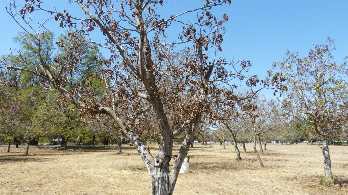
‘Devastation’: South Shasta County residents deal with drought conditions not seen in 100 years
Damon Arthur – August 29, 2022
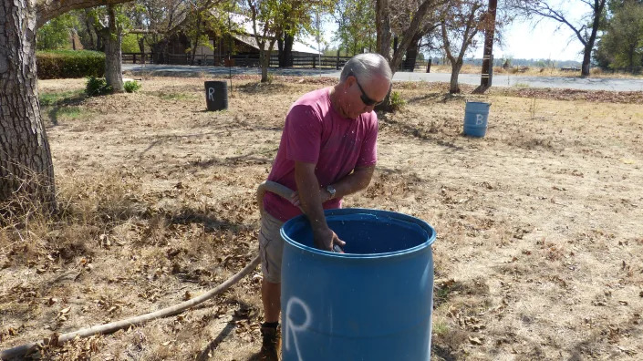
Ed Roberts drives his truck out into Bill Robison’s, left, orchard to fill barrels used to water Robison’s walnut trees. Roberts’ wife, Elaine Roberts, helps carry hose.
Bill Robison has a “lifesaver” who drives a 1973 Ford truck.
A couple times a week, Ed Roberts rolls up to Robison’s house with a 500-gallon tank of water in the bed of his pickup. The truck bounces out into Robison’s orchard along Balls Ferry Road in Anderson, where the two fill barrels with water.
At this time of year Robison usually floods his pecan and walnut orchards with irrigation water from the Anderson-Cotttonwood Irrigation District.
But for the first time in its 106-year history, the district this year did not supply water to residents in southern Shasta and northern Tehama counties.
Residents and local officials said the effect of losing irrigation has hurt the economy, residents and wildlife.
Laurrie Shaw, whose family owns a ranch off Balls Ferry Road, said a group she belongs to called the Anderson-Cottonwood Irrigation District Water Users Association hired a consultant to assess the impacts on the area.
“He was shocked at the devastation that had taken place at that point, when we still had half of our hot weather left to go,” Shaw said.
Josh Davy, a livestock and pasture advisor for the University of California Cooperative Extension, said cattle ranchers and other growers have been hit hard.
Most of the agriculture in the district is pastureland, Davy said.
“So losing it, it’s not just property value, but the overall scheme, the production. And what’s the fallout to our local stores that supply these people and everything else? So yeah, it’s scary right now,” Davy said.
Drought three years in the making
The third year of the drought began to take shape last winter when the rain stopped falling in January, and the meager amounts of precipitation persisted through the spring.
Due to the drought and reduced water allocations from the U.S. Bureau of Reclamation, district officials said last spring they did not have enough water to send down its network of canals to its 800 customers.
With no irrigation, the thousands of acres of green pastures and wetlands in the south county died and turned brown and yellow. Scores of trees throughout the 7,000-acre district also withered and died.
Officials with the California Department of Forestry and Fire Protection have warned that the area poses a fire danger that residents have not seen before.
Several trees in Bill Robison’s orchard in Anderson died this year because of the drought.
The bureau supplies water to most water agencies in western Shasta County, as well as irrigation districts throughout the Sacramento Valley. Most of those agencies had their water allotments cut severely.
Because the district has senior water rights, it is typically immune to having its water allocation reduced by more than 25%, she said.
But the North State has not had a typical water year in three years.
Lake Shasta, a major water source to much of California, was only 35% full and at 57% of average for late August. Even though the lake is low, the water level is about 24 feet higher than last year.
Lake Shasta is primarily filled by rainfall, and precipitation remained low for the North State. Redding has received just over 5 inches of rain since January, less than a quarter of its normal rainfall, according to the National Weather Service.
The U.S. Drought Monitor places most of the North State in an “extreme” drought.
Not enough water to go around
Because of the ongoing dearth of precipitation, A.C.I.D.’s allotment was reduced to 22,500 acre-feet of water, about 18% of what it gets in a normal year, said Brenda Haynes, president of the A.C.I.D. board.
Because that amount had to be spread throughout the irrigation season, from April to October, it was not enough to fill the district’s canals to the point water could flow all the way to Anderson and Cottonwood, Haynes said.
Also a concern was that the district canals aren’t lined with concrete, which would have meant that the water would have soaked into the ground underneath before it reached customers’ fields, she said.
So instead of wasting the water, the district sold it to be used for drinking water by local agencies such as the city of Redding, the Bella Vista Water District, the city of Shasta Lake and Shasta Community Services District.
Some of the water was also sold to use as irrigation to the Tehama Colusa Canal Authority, Haynes said.
Haynes said many of the district’s customers don’t understand why they did not receive irrigation water this year. Some district board of directors meetings have drawn up to 160 people, and many of them angry that their crops and pastures are dried up, she said.
South county residents have formed the water users association to help spread information about the impacts on the area.
Neighbors helping neighbors
Roberts said he found out about Robison and his orchard through the association.
Robison grows mainly pecan and walnut trees on his 7 acres, but he also has apples, peaches and pear trees.
“But they’re not doing so good. It’s knocked them down bad. I mean, we didn’t get any fruit at all hardly, just little bitty stuff that ain’t worth eating,” he said.
Even though it was only August, the leaves on Robison’s trees had already begun to turn brown.
Many of the trees had dropped early their leaves, littering the ground with dry, brown leaves that crunched as Robison walked through his pecan orchard.
He estimates 15 of his walnut trees and four pecan trees had died this year due to lack of water.
He usually floods his orchard with A.C.I.D. water in the summer months.
But this year Robison has 55-gallon barrels set out near his walnut trees. After he and Roberts fill the barrels, the water slowly leaks out through a small hole at the bottom of each container, like a trickle irrigation system.
Roberts, who lives in the district, has also delivered water to others suffering through the dry summer.
“He’s a lifesaver. I’ll tell you, he’s one heck of a guy,” Robison said of his friend.
Roberts said through the water users association he heard about residents in the south county whose wells had gone dry because of the groundwater level dropping, so he initially delivered water to five people.
“I had the ability and the means, so just I felt like I needed to,” Roberts said.
Roberts fills his tank with excess water from Shasta Sustainable Resource Management, a co-generation plant formerly known as Wheelabrator.
By late August, he was down to supplying water to two people, he said. He no longer bothers to take the tank out of the bed of his pickup unless he needs to haul hay for his own cattle.
Wells go dry throughout Shasta County
The loss of A.C.I.D. irrigation water has a secondary effect beyond watering crops and pasture, said Charleen Beard, a supervising engineer with the Shasta County Public Works Department.
The flood irrigation and the district’s network of canals also recharges billions of gallons into the underground aquifer annually. She said the annual irrigation adds from 30,000 acre-feet to 40,000 acre-feet of water a year.
Haynes said the groundwater recharge from district irrigation is about 77,000 acre-feet annually.
An acre-foot of water is about 326,000 gallons of water, enough to supply water to one-half to one California household for a year.
Without the irrigation water recharging the aquifer, the groundwater table in the area served by A.C.I.D. has fallen, Beard said. However, she said the county won’t know how much until it does measurements in October.
Dozens of residents in several areas in the county are reporting residential wells going dry from Lakehead and Oak Run to Millville to Anderson and Cottonwood, she said.
The county has a program to provide financial assistance to residents who need to drill a new water well or sink an existing one deeper, she said. Countywide, there were 36 applications for assistance, 22 of those in the A.C.I.D. district boundaries, Beard said.
But residents who want new or deeper wells may be waiting for weeks, she said, because well drillers have a backlog of clients waiting for help.
Bill Robison of Anderson fills a barrel to water trees in his orchard. Robison usually irrigates his trees with water from the Anderson-Cottonwood Irrigation District, but the agency did not supply its customers this year.
The county also provides bottled water and delivers water by truck, she said. The well drilling assistance is provided based on financial income qualifications, Beard said.
But bottled and hauled water is free for those whose wells have gone dry, Beard said.
Cattle ranchers sell their herds
Davy said cattle ranchers will likely feel the impact of irrigation shut-offs beyond this summer.
Many ranchers were forced to sell their cows and calves last spring because the pasture they fed on died from lack of irrigation.
“So the cow base in northern Tehama and southern Shasta has significantly dropped. It’ll take years to recover from that,” he said.
Because the bureau did not fulfill its contract to provide the water owed to the district, there have been discussions about whether the bureau would provide reparations to ranchers and farmers, Davy said.
“But we have no idea how that will unfold or whether the water users would even get it at this point,” he said.
Like many other areas withing the Anderson-Cottonwood Irrigation District boundaries, a pasture that is typically green along Deschutes Road in Anderson has turned brown this year.
Wildlife also takes a hit from the drought
Humans aren’t the only ones affected by the ongoing drought, Shaw said.
The irrigation canals and the pastures around them acted as wetland areas that supported water birds, insects, frogs and other small animals.
“I can’t help but think the terrible impact to natural environment is the most serious aspect of no water. It’s inconceivable that the Mouth of Cottonwood Creek Wildlife Area has been allowed to go dry. Anderson Creek and all its habitat is dead,” Shaw said.
The wildlife area consists of 1,100 acres situated along Cottonwood Creek where it flows into the Sacramento River. The area is owned and managed by the California Department of Fish and Wildlife.
Peter Tira, a spokesman for the department, said that before irrigation cutbacks, the area received water from the A.C.I.D.
Even though water from the district did not flow into the wildlife area this summer, he said the animals living there are drought-adapted and still have access to water in Cottonwood Creek and the Sacramento River.
Mike Berry, a former fish and wildlife environmental scientist, said throughout the area served by the district, the effects on wildlife have been significant.
“There has also been mass killing of field mice, voles, and other small rodents with a small home range that could not travel all the way to the river for water,” Berry said in an email.
“For over 100 years the water has been delivered to them. The death of tens of thousands of these animals seems minor except these all form the base of the food chain for foxes, bobcats, herons, egrets, owls, raptors, snakes, bats etc. This loss of food source occurred at the height of young rearing for most of these species,” Berry said.
Damon Arthur is the Record Searchlight’s resources and environment reporter. He is part of a team of journalists who investigate wrongdoing and find the unheard voices to tell the stories of the North State.
We’re in the middle of sweet corn season: Here are some easy ways to cook, store it
Susan Selasky, Detroit Free Press – August 29, 2022
Sweet corn.
When it comes to produce that is fresh, sweet, and tasty, it doesn’t get any better than sweet corn. And we are smack dab in the middle of sweet corn season.
Loads of yellow, white, and bi-color corn are landing at many metro Detroit local farm markets, independent stores and farmers’ markets.
Fred Block of Block’s Stand and Greenhouse in Romulus said the crop is big and it’s coming in good.
“It’s (corn season) in full swing with good varieties, good size ears, and good flavor,” Block said.
At Block’s, corn is sold by how many you can fit in a bag. The bags are two for $5 and easily hold a dozen ears of corn.
Ben Phillips, a Michigan State University Extension vegetable specialist, also said this year’s corn season in Michigan is excellent.
While there was a little dry stress early, Phillips said rains were well timed, pollination happened and pests were low.
“There’s a lot of high-quality ears out there,” Phillips said. “Conditions have been good for tip fill.”
For good tip fill, Phillips said, when you’re holding that ear of corn, the tip has to feel “stubby, not pointy.”
“That means all the kernels to the end have filled out,” he said.
Cooking corn
Ever have cooler corn? It’s an easy way to cook corn for a crowd. Yes, that same cooler that keeps beer, pop and foods cold can keep things hot, too.
Cooking corn in a cooler is quick and easy.
Here’s how:
Clean your cooler, making sure you wash and rinse it out well.
Make sure you have a lid.
Shuck the corn and place it in the cooler. You can line them up in a single or double row — depending on the size of your cooler.
Boil some water — enough to completely cover the ears by an inch or more.
Cover with the lid. Let sit at least 30-45 minutes or until the corn is cooked. If you like you can throw in a stick of butter too.
Silk-free microwave corn
A few minutes in the microwave and how you remove the husk leads to silk-free corn.
Here’s how:
Leave the corn in the husk but remove as much of the silk as you can. I use scissors to trim it away.
Place the corn on a microwave-safe plate or dish. Microwave on high for about 3 minutes, depending on the size of the ear.
The corn will be hot so use oven mitts or a towel to remove it from the microwave.
Place corn on a work surface and cut about ½-inch off the larger end.
Holding the silk end, squeeze or twist the husk so the ear of corn slips out. The silk stays in the husk.
Storing corn
Store freshly picked corn in a bag in the refrigerator and use it within a few days. Do not remove the husk.
Corn also freezes beautifully. Cut the kernels from the cob and place them in a freezer-quality bag and in the freezer. There’s no need to blanch the corn. You can also freeze cooked corn.
You can also freeze the whole cobs of corn. Remove the husk and silk and blanch in boiling water 3-4 minutes. Place in an ice bath to stop the cooking. Pat corn dry and place in a freezer bag, pressing out as much air as possible.
To easily cut corn from the cob, break the ear in half. Stand the ear on the cut side and slice kernels from top to bottom. Having two smaller pieces standing upright is easier than trying to cut the kernels from a whole ear.