
Los Angeles Times
The Colorado River is overused and shrinking. Inside the crisis transforming the Southwest
Ian James, Molly Hennessy-Fiske, January 26, 2023
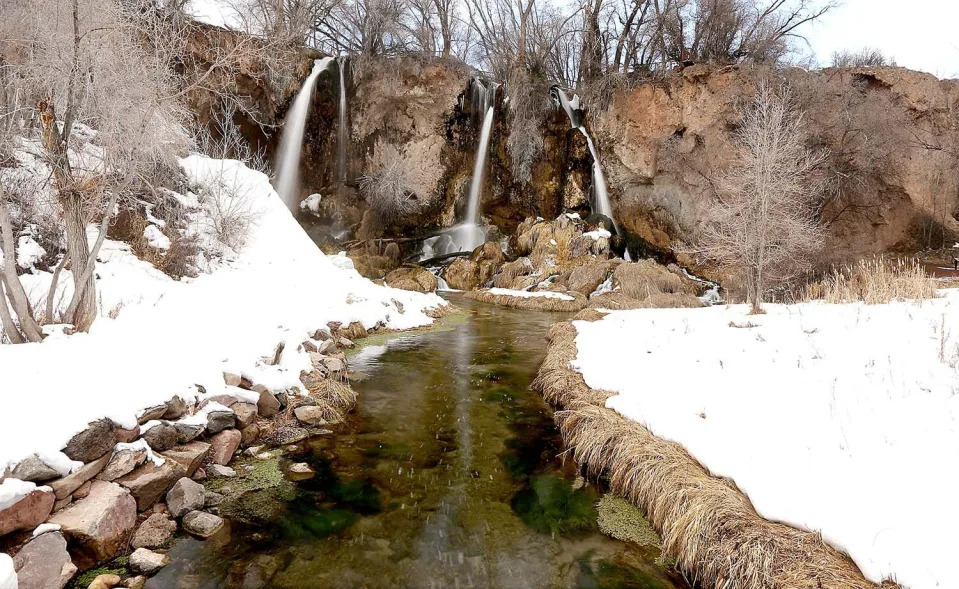
The Colorado River begins as melting snow, trickling from forested peaks and coursing in streams that gather in the meadows and valleys of the Rocky Mountains.
Like arteries, its major tributaries take shape across Colorado, Wyoming, Utah and New Mexico, coming together in a great river like no other — a river that travels more than 1,400 miles and has defined the rise of the American Southwest over the last century.
Water diverted from the river has enabled agriculture to spread across 5 million acres of farmland and has fed the growth of cities from Denver to Los Angeles, supplying about 40 million people. Harnessing the river’s bounty has provided the foundation for life and the economy across seven states and northern Mexico.
But the region has for years depended too heavily on the river, taking more than its flows can support. And in recent years, the river’s water-generating heart in the Rocky Mountains has begun to fail.
The Colorado River can no longer withstand the unbridled thirst of the arid West.
A century ago, the signing of the Colorado River Compact divided the water among the states. The agreement established a system that overpromised what the river could provide. That system, after years of warnings from scientists and insufficient efforts to adapt, is now colliding with the reality of a river that is overused and shrinking.
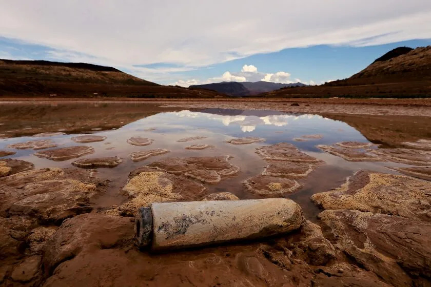
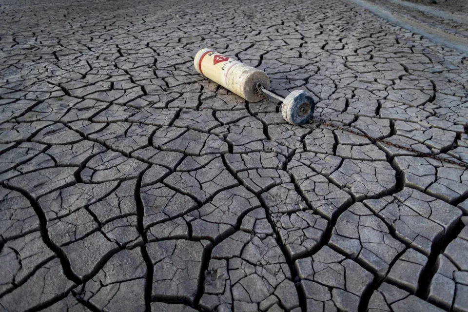
In the last 23 years, as rising temperatures fueled by the burning of fossil fuels have intensified the worst drought in centuries, the flow of the Colorado has declined about 20%.
Reservoirs have dropped to record-low levels, and the shortage continues to worsen. Scarcity is pushing the region toward a water reckoning.
The looming consequences include major cuts in the supplies used for growing crops and sustaining cities. How those water reductions are divided among states, water districts and tribes has yet to be determined, and could end up being negotiated, dictated by the federal government or fought in court. But the need to shrink overall water use will probably result in less water flowing to farms, more water restrictions for residents and fewer green lawns, while also bringing calls for limiting growth, shifting away from thirsty crops like alfalfa, and dedicating less water to golf courses and other water-guzzling businesses.
The Colorado River Basin, which stretches from Wyoming to northern Mexico, is facing unresolved questions about how to adapt, at what cost, and where the cuts will fall the hardest.
The task of downsizing water use is complicated by an allocation system that promised now-nonexistent water on paper, as well as a legal system that benefits those with the oldest, most senior water rights.
Over the last several years, managers of water agencies have reached deals to take less water from the river. But those reductions haven’t been nearly enough to halt the river’s spiral toward potential collapse.
As Lake Mead, the nation’s largest reservoir, continues to decline toward “dead pool” levels, the need to rein in water demands is growing urgent.
Efforts to adapt will require difficult decisions about how to deal with the reductions and limit the damage to communities, the economy and the river’s already degraded ecosystems. Adapting may also drive a fundamental rethinking of how the river is managed and used, redrawing a system that is out of balance. This reckoning with the reality of the river’s limits is about to transform the landscape of the Southwest.
Navigating through a forest of snow-covered pines, Brian Domonkos skied up to a site high in the Rocky Mountains, the source of the Colorado River.
He had come to check the snowpack at an isolated stand of monitoring equipment near Berthoud Pass, Colo., where the day before 5 inches of snow had fallen.
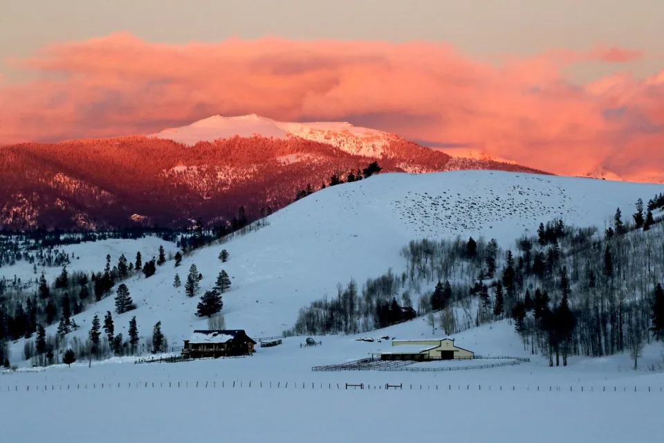
“I hope this holds on a little while longer,” said Domonkos, a snow survey supervisor for the federal Natural Resources Conservation Service. He was concerned that even with the snowfall, Colorado seemed headed for a below-average snow year.
Last spring, the snowpack across the Upper Colorado River Basin stood at 86% of average. By the end of July, however, the melting snow brought runoff that measured just 67% of average.
This pattern has emerged year after year in the river’s headwaters. A near-average snowpack has often translated into meager flows in the Colorado River and its tributaries.
This winter, storms have brought an above-average snowpack in the watershed. But that snow can go only so far in boosting reservoirs that have been dropping for more than two decades.
Average temperatures across the upper watershed — where most of the river’s flow originates — have risen about 3 degrees since 1970. That has contributed to the driest 22-year period in at least 1,200 years.
With higher temperatures, trees and other plants have been absorbing more water, and more moisture has been evaporating off the landscape.
In recent years, long dry spells in the mountains have left the soils parched. And when the snow has melted in the spring, the amount of runoff flowing in streams has often been diminished.
“We are seeing less water,” Domonkos said. “And we’re going to have to adapt.”
The river’s mainstem takes shape in Rocky Mountain National Park, winding through an alpine valley, then flows into reservoirs and meanders through ranchlands.
On one of these ranches, Wendy Thompson can see the river standing outside her house. She walked to the banks, where muddy brown water flowed swiftly past.
“This time of year, it ought to be another foot, 2 feet deeper,” Thompson said.

Thompson is 67 and remembers much more snow in Colorado when she was growing up. The flooding river used to swell across the pastures.
“In 1985 was the last time we really had a flood here,” she said.
Upstream diversions and dry years have left the river smaller. Some sections on her ranch now usually flow less than 2 feet deep.
In late spring and early summer, Thompson pumped from the river to irrigate her hay fields, and sold the crop to other ranchers.
Many ranchers have had less water for their pastures lately, and some have sold cattle to reduce their herds.
“Everyone knows that we’re dry,” Thompson said. “In this area, when there’s no water, you just don’t irrigate.”
Upstream from western Colorado’s ranchlands, water is diverted and routed to the east, flowing through a series of tunnels that pass beneath the Continental Divide to supply Denver and other growing Front Range cities. Two new reservoir projects are under construction to hold more water — the Chimney Hollow Reservoir and the expansion of Gross Reservoir.
The diversions from Grand Lake are a source of concern for Ken Fucik, a retired environmental scientist and board member of the Upper Colorado River Watershed Group. He said he is worried about water quality and recent algae blooms in the lake and adjacent reservoirs.
Fucik questioned whether the new reservoir projects make sense when the river’s existing reservoirs are rapidly declining.
“Where is that water going to come from?” he said.
For more than a century, the history of the Colorado River has been shaped by monumental human efforts to control and exploit its waters to the maximum.
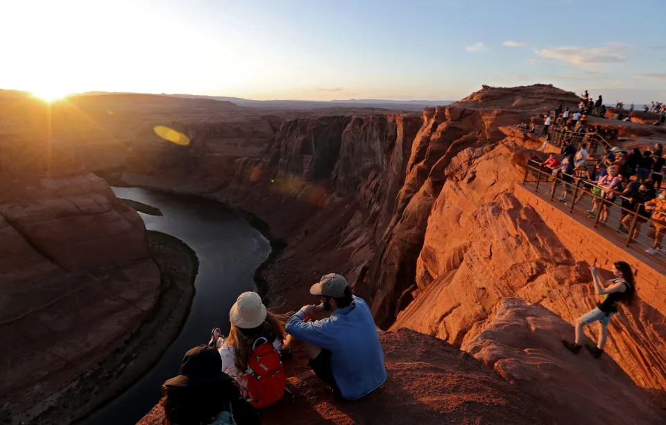
The river has been flowing in its course for millions of years, downcutting through layers of sandstone, limestone, granite, shale and schist to form the Grand Canyon.
Indigenous peoples have lived along the river and its tributaries for thousands of years, adorning rocks on canyon walls with petroglyphs and pictographs.
The river’s Spanish name, colorado, or red, described the muddy, silt-laden waters that coursed through canyons.
In the mid-1800s, as white settlers moved west, steamboats chugged up the lower Colorado River, paddlewheels turning. Settlers began diverting water from streams and rivers, taking water rights under the prior appropriation system — “first in time, first in right.”
Water was seen as a source of wealth to be seized. The great ambition of politicians, engineers and fortune-seekers was to tame the river and harness its water.
In the early 1900s, they focused on building irrigation projects to “reclaim” the arid lands, a phrase central to the purpose of the Reclamation Service, which was created in 1902 under President Theodore Roosevelt and which later became the Bureau of Reclamation.
From the beginning, some warned against relying too heavily on the river. John Wesley Powell, leader of the historic 1869 expedition down the river through the Grand Canyon, famously told attendees at an 1893 irrigation congress in Los Angeles: “I tell you, gentlemen, you are piling up a heritage of conflict and litigation over water rights, for there is not sufficient water to supply these lands.”
Before the signing of the 1922 Colorado River Compact, some scientists warned that there was insufficient water, but those warnings went unheeded.
The compact apportioned the river “in perpetuity,” allocating 7.5 million acre-feet of water for the Upper Basin states — Colorado, Wyoming, Utah and New Mexico — and 7.5 million acre-feet for the Lower Basin states of California, Arizona and Nevada. Mexico later secured 1.5 million acre-feet under a 1944 treaty.
The river was divided among the states during an especially wet period in the early 20th century.

Hoover Dam was built during the Great Depression in the 1930s. Workers finished pouring the concrete at Glen Canyon Dam in 1963. As described by Los Angeles Times columnist Michael Hiltzik, the dams and reservoirs “created only the illusion of abundant water, not the reality.”
Over the last half a century, so much water has been diverted that for many years the river has been entirely used up, leaving dusty stretches of desert where it once flowed to the sea in Mexico.
Even in the 1980s, when plentiful water filled the reservoirs, some presciently warned that the Colorado could not withstand all the demands placed upon it.
In the seminal 1986 book “Cadillac Desert,” Marc Reisner predicted chronic shortages in the years to come, saying the region had already begun to “founder on the Era of Limits.”
The strains on the river have grown more acute with humanity’s heating of the planet. In the 1990s and 2000s, scientists repeatedly warned that chronic overuse of the river combined with the effects of climate change would probably drain reservoirs to dangerously low levels.
During the last decade, scientists have found that roughly half the decline in the river’s flow has been due to higher temperatures; that climate change is driving the aridification of the Southwest; and that for each additional 1 degree Celsius (1.8 degrees Fahrenheit), the river’s average flow is likely to decrease about 9%.
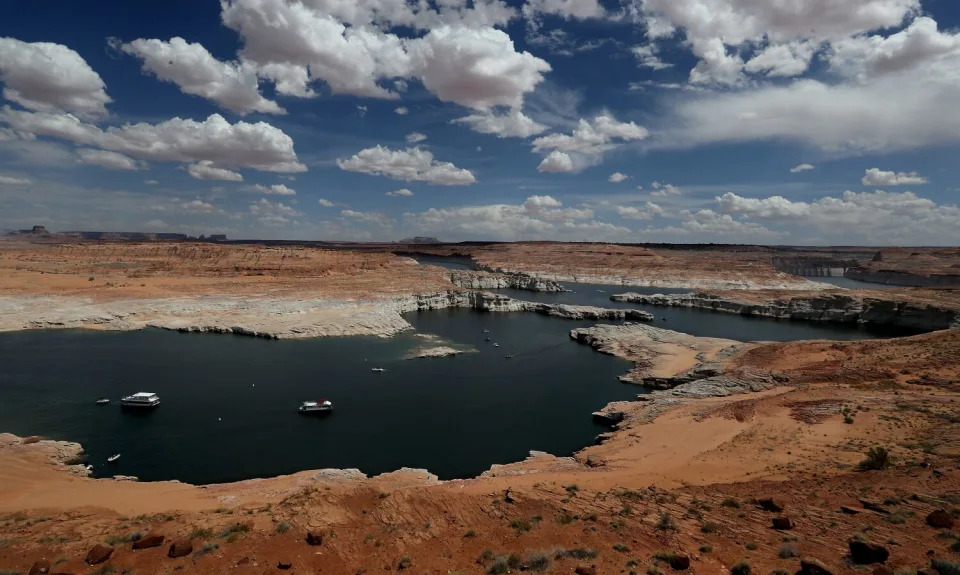
The drying of the Colorado’s upper reaches has shrunk the flow and accelerated the declines of Lake Powell and Lake Mead.
The system of dividing the water, including the agreement signed a century ago, was designed for a climate that no longer exists, said Becky Bolinger, assistant state climatologist at the Colorado Climate Center. Continuing this pattern of overuse, she said, is like depleting a bank account by overspending, edging closer to bankruptcy.
“It’s not going to work for anybody,” Bolinger said. “What we really need to do is just completely readjust the budget.”
The federal government has begun to lay the groundwork for scaling back water use.
Interior Department officials have said annual diversions need to be reduced by 2 million to 4 million acre-feet, or about 15% to 30%. They have urged the seven states that rely on the river to reach a consensus, while warning they may need to impose cuts.
So far, negotiators for states and water agencies have failed to agree on how to share such large reductions. Some fear these disputes could lead to lawsuits.
As the reservoirs’ levels continue to drop, time is swiftly running out.
“We have got to put the kibosh on these extra water uses right now, the uses of water beyond what’s being supplied. Either we stop them or nature will,” said Brad Udall, a water and climate scientist at Colorado State University. “Make no mistake. This is a full-on five-alarm fire going on right now.”
The Colorado River has reached this critical stage in a decade when extreme droughts have shrunk other rivers to historic lows around the world, from the Mississippi and the Rio Grande to the Yangtze in China, and the Danube and Rhine in Europe.
Research has shown that climate change is intensifying the water cycle, bringing more intense and frequent droughts, as well as more intense rainfall and floods. In one recent study, researchers found that streams in the western and southern United States have been drying over the last 70 years, with flow data revealing longer and more severe low-flow periods.
Even as wet and dry cycles continue to come and go, the Colorado River is on a long-term downward trend of aridification because of higher temperatures, Udall said.
“It’s fundamentally changing, and it’s not going to go back to how it was before,” Udall said. “We’re going to have to talk about permanent reductions in water use.”