Colorado River crisis is so bad, lakes Mead and Powell are unlikely to refill in our lifetimes

Los Angeles Times

Colorado River crisis is so bad, lakes Mead and Powell are unlikely to refill in our lifetimes

Rong-Gong Lin II, Ian James – February 5, 2023

Scenes around Lake Mead as persistent drought drives water levels to their lowest point in history.
Boaters are dwarfed by a white bathtub ring around Lake Mead. (Luis Sinco/Los Angeles Times)

The snowpack in the Sierra Nevada is the deepest it’s been in decades, but those storms that were a boon for Northern California won’t make much of a dent in the long-term water shortage for the Colorado River Basin — an essential source of supplies for Southern California.

In fact, the recent storms haven’t changed a view shared by many Southern California water managers: Don’t expect lakes Mead and Powell, the nation’s largest reservoirs, to fill up again anytime soon.

“To think that these things would ever refill requires some kind of leap of faith that I, for one, don’t have,” said Brad Udall, a water and climate scientist at Colorado State University.

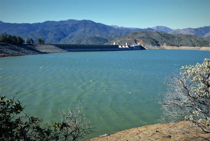
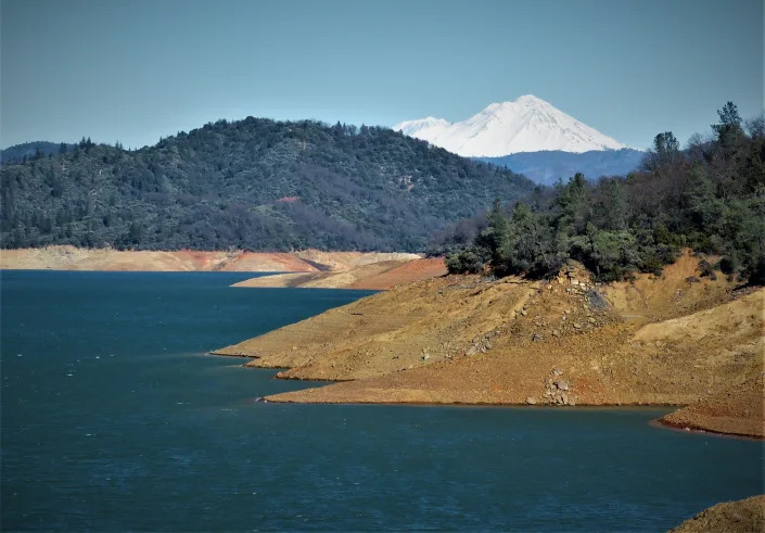
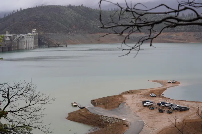
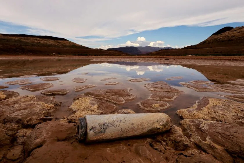
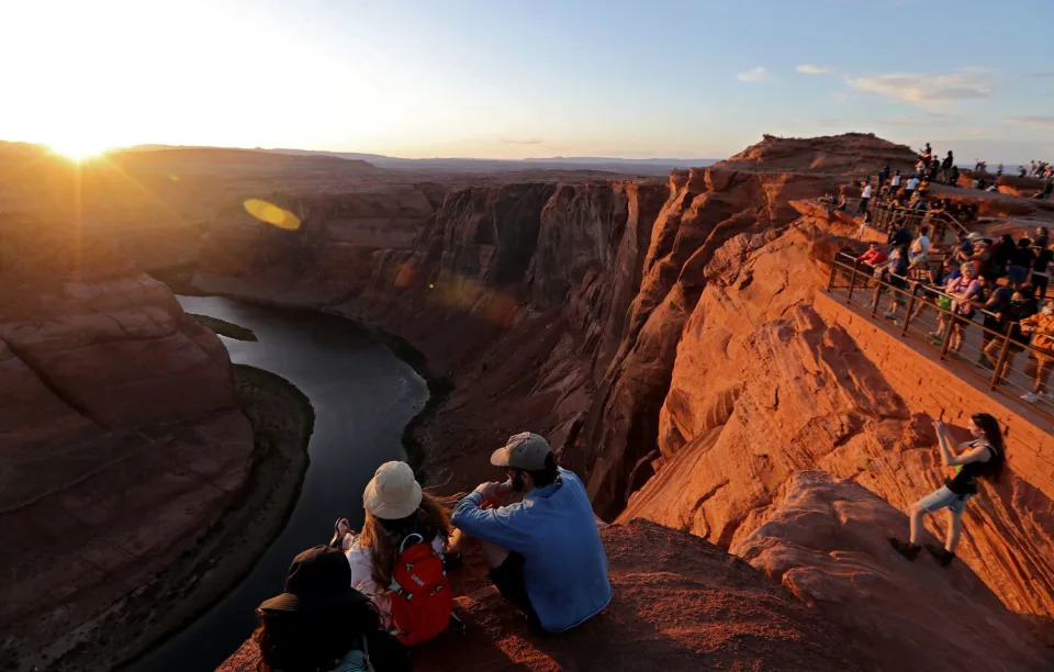
Lake Mead, located on the Arizona-Nevada border and held back by Hoover Dam, filled in the 1980s and 1990s. In 2000, it was nearly full and lapping at the spillway gates. But the megadrought over the last 23 years — the most severe in centuries — has worsened the water deficit and left Lake Mead about 70% empty.

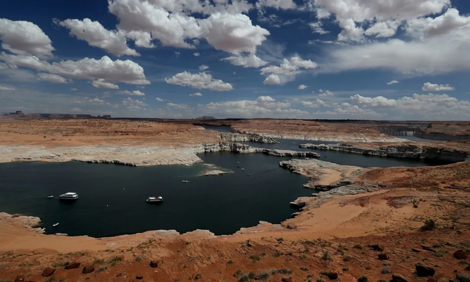
Upstream, Lake Powell has declined to just 23% of full capacity and is approaching a point where Glen Canyon Dam would no longer generate power.

Even with this winter’s above-average snowpack in the Rocky Mountains, water officials and scientists say everyone in the Colorado River Basin will need to plan for low reservoir levels for years to come. And some say they think the river’s major reservoirs probably won’t refill in our lifetimes.

“They’re not going to refill. The only reason they filled the first time is because there wasn’t demand for the water. In the 1950s, ’60s, ’70s and ’80s, there was no Central Arizona Project, there was no Southern Nevada Water Authority, there was not nearly as much use in the Upper [Colorado River] Basin,” said Bill Hasencamp, manager of Colorado River resources for the Metropolitan Water District of Southern California. “So the water use was low. So that filled up storage.”

Demand for Colorado River water picked up in the late 1990s and early 2000s. The Central Arizona Project, a 336-mile-long water delivery system, brings water from the Colorado River to Arizona’s most populous counties and wasn’t completed until the 1990s. The Southern Nevada Water Authority was created in 1991.

Arizona began starting to take its full apportionment of river water in the late 1990s, and Nevada in the early 2000s. California continues using the single largest share of the river.

“Now the water use is maxed out. Every state is taking too much, and we have to cut back. And so there’s just not enough. You would need wet year after wet year, after wet year after wet year, after wet year. Even then, because the demand is so high, it still wouldn’t fill,” Hasencamp said in an interview.

Climate change has dramatically altered the river. In the last 23 years, as rising temperatures have intensified the drought, the river’s flow has declined about 20%.

Scientists have found that roughly half the decline in the river’s flow has been caused by higher temperatures, and that climate change is driving the aridification of the Southwest. With global warming, average temperatures across the upper watershed — where most of the river’s flow originates — have risen about 3 degrees since 1970.

Research has shown that for each additional 1 degree Celsius (1.8 degrees Fahrenheit), the river’s average flow is likely to decrease about 9%.

In multiple studies, scientists have estimated that by the middle of this century, the average flow of the river could decline by 30% or 40% below the average during the past century.

“The last 23 years are the best lessons we have right now, and they should scare the pants off of people,” said Udall, who has been a co-author of research showing how warming is sapping the river’s flows.

Based on the low levels of Lake Mead and Lake Powell, Udall said, he would estimate that refilling the reservoirs would take roughly six consecutive extremely wet years, with water flows similar to those in 2011.

“We’d need six years like that to refill this system, in a row, based on current operating rules,” Udall said. “And I just don’t see that even being remotely possible.”

The Colorado River Basin very well could get a few wet years, he said.

“We might even get a wet decade. But, boy, the long-term warming and drying trend seems super clear to me,” Udall said. “And a bet on anything other than that seems like water management malpractice, that we have got to plan for something that looks like a worst-case future.”

The Colorado River supplies water to seven states, tribal nations and Mexico. The states are under pressure from the federal government to agree on cuts to prevent reservoirs from dropping to dangerously low levels.

California and the six other states are at odds over how to make the cuts, and have submitted separate proposals to the federal government, with some disagreements centering on the legal system that governs how the river is managed.

Scientists have warned of a coming crisis for many years.

In a 2008 study, scientists Tim Barnett and David Pierce examined the likely flow declines with climate change and estimated there was a 50% chance the usable water supply in Lake Mead and Lake Powell would be gone by 2021. They titled their study “When Will Lake Mead Go Dry?” In research published in 2009, they wrote that based on projections with climate change or even the long-term average flows, “currently scheduled future water deliveries from the Colorado River are not sustainable.”

“Climate change is reducing the flow into the Colorado River system, so the agreements are divvying up more water than exists,” said Pierce, a climate scientist at Scripps Institution of Oceanography. “This drop in reservoir levels is happening because we are abiding by agreements that do not account for changes in water inflow into the system due to climate change.”

There is always the chance of a few extremely wet years with the potential to refill reservoirs, Pierce said.

“It’s just that in the coming decades that likelihood decreases. Our work has estimated that the chance of the reservoirs refilling decreases from about 75% today to about 10% by 2060 if no changes in [water] delivery schedules are made,” Pierce said. “We should be planning for the situation where the hotter temperatures decrease the river flow in the future.”

The capacity of lakes Mead and Powell is gargantuan compared with the capacity of California’s two largest reservoirs, Shasta Lake and Lake Oroville. Lake Mead can store more than 27 million acre-feet of water, and Lake Powell 25 million acre-feet. By contrast, Shasta Lake can hold about 4.6 million acre-feet, and Lake Oroville 3.5 million acre-feet.

The Colorado River supplies, on average, about 25% of the water supplies in coastal Southern California, while the region also gets water from Northern California through the State Water Project, and other sources.

California’s Sierra Nevada snowpack is now about 200% of average at this point in the season, while the snowpack in the Upper Colorado River Basin so far stands at about 140% of the median over the last 30 years.

The bigger snowpack could help the Colorado’s reservoir levels this year somewhat. How much won’t be clear for a few months.

“Absolutely this snow is welcomed. The cold weather is welcome. The real question will be in the spring,” Hasencamp said.

In recent years, hot, dry conditions have led to reduced flows in the river. “That’s what’s been the killer the last few years, is a hot dry spring has taken the snow that’s been there, and it doesn’t make it to the reservoirs,” Hasencamp said.

Daniel Swain, a UCLA climate scientist, said an exceptionally wet decade might someday change things.

“But the problem is, it doesn’t just have to be wetter than average, it would have to be dramatically wetter than the long-term average,” Swain said. And for many years.

Scientists say higher temperatures effectively make the atmosphere “thirstier,” causing more moisture to evaporate off the landscape. Vegetation also takes up more water as temperatures rise, leaving less runoff flowing in streams.

“There is no question that there will be an ongoing downward trend in inflows, but extreme high events are also more likely to occur in the context of climate change, according to the U.S. National Climate Assessment,” said Kathy Jacobs, director of the University of Arizona’s Center for Climate Adaptation Science and Solutions.

Jacobs noted that researchers project atmospheric rivers will become more intense with rising temperatures, and scientists expect more intense extreme storms and periodic flooding.

“I strongly suspect that the dams on the Colorado will be needed for flood control in the future as well as for water supply,” Jacobs said.

As for the future, Jacobs said a great deal depends on whether greenhouse gas emissions are reduced “to net zero in the near term.”

There are workable ways of managing reduced water supplies from the river, she said. “The longer we wait to build more flexible future management schemes, the harder it will be.”

LISTEN: Colorado River in Crisis Podcast

As suicide rate keeps rising in Wisconsin, concentration in rural areas raises alarm

USA Today

As suicide rate keeps rising in Wisconsin, concentration in rural areas raises alarm

Natalie Eilbert – February 2, 2023

If you or someone you know is dealing with suicidal thoughts, call the National Suicide Prevention Lifeline at 988 or text “Hopeline” to the National Crisis Text Line at 741-741.

Karen Endres knows that farming involves stress unlike other occupations.

Its main variables — weather, livestock, crops, sales — are largely beyond control. Physical demands and time commitment never ease. Family relationships, management practices and work-life balance all overlap. In how many jobs, after all, might three generations of a family work, live and plan for the future together?

And if that business isn’t going well, who do they talk to?

“We don’t have a community to connect with others about mental health and stressors,” said Endres, who operates a dairy farm with her husband, and works as the farmer wellness coordinator at Wisconsin Farm Center’s Farmer Wellness Program, part of the state Department of Agriculture, Trade and Consumer Protection. “It can lead us to very dangerous places.”

The most recent Suicide in Wisconsin report shows a 32% increase in suicides in Wisconsin from 2000 to 2020. Suicide is now the state’s 10th leading cause of death. Over the last three years combined, suicide rates were higher among rural residents than among urban residents. And overwhelmingly, the suicides were among men.

Some rural counties dwarf the state suicide rate.

According to the Wisconsin Violent Deaths Reporting System, Milwaukee County’s rate of suicide deaths was about 12 per every 100,000 people in 2018, the most recent year of comprehensive reporting. Nearly 300 miles north in Ashland County, the rate of suicide deaths was about 25 per every 100,000. Milwaukee County has a population of nearly 930,000. Ashland’s population: About 16,000.

“North of Green Bay, the population is very sparse and resources are very sparse. You have a high proportion of veterans living in those counties, higher proportions of firearm ownership in those counties, and so there’s just a number of factors that play into that,” said Sara Kohlbeck, an assistant professor in the Department of Psychiatry at the Medical College of Wisconsin.

Kohlbeck conducts research in suicide and suicide prevention across different communities in Wisconsin. In 14 years, Kohlbeck has analyzed the deaths of nearly 200 Wisconsin farmers who died by suicide.

One farmer ended his life the day after receiving a change of address card in the mail from his wife, who’d recently left him. Another died a week after being “disgusted” over not being able to cut his own toenails, a result of new physical limitations. Yet another had just finished a phone call with a loan company. Another had a disappointing crop, the latest in a string of bad years. Still, others had blood alcohol content many, many times the legal limit.

Over 70% of farmer suicides involved firearms.

Kohlbeck and her team divided the hardships faced by farmers into five categories: acute interpersonal loss (a wife leaving), rugged individualism (a man facing new limitations), financial stress (a phone call from a loan company), the pressure of providing (struggling with the crops) and the lethal combination of alcohol and firearms.

“They’re just in an untenable scenario of inescapable pain,” Kohlbeck said. “Physical health issues, substance abuse, not having access to care, not being able to put food on the table — a lot of what I see is basic needs-related issues … that lead them to wanting to escape the situation they’re in.”

Chris Frakes is the group director of the Southwestern Wisconsin Community Action Program, an anti-poverty agency. Every three years, it does a community needs assessment for the five counties it oversees. In 2017, Frakes had heard so many stories of farmers struggling to get by, she expected them to reach out for help. But few did.

The silence and the growing farm crisis led to the program getting creative about upstream prevention. In 2021, it received nearly $1 million from the Wisconsin Partnership Program at the University of Wisconsin School of Medicine and Public Health to target farmers’ mental health over a five-year period.

But Frakes is the first to admit that assessing the needs of farmers involves face-to-face interactions, ability to crack coded language and, above all things, development of trust. To do so requires people to understand the culture.

“We’re trying to really empower community members to not only recognize when somebody’s in a crisis, or when somebody’s struggling with thoughts of suicide but also to notice when somebody’s really stressed or struggling,” Frakes said.

Karen Endres works as the farmer wellness coordinator at Wisconsin Farm Center's Farmer Wellness Program, part of the Wisconsin Department of Agriculture, Trade and Consumer Protection. She frequently pays visits to fellow farmers to learn about their specific mental health needs.
Karen Endres works as the farmer wellness coordinator at Wisconsin Farm Center’s Farmer Wellness Program, part of the Wisconsin Department of Agriculture, Trade and Consumer Protection. She frequently pays visits to fellow farmers to learn about their specific mental health needs.
Domino effects of self-blame in farmer culture

Brenda Statz, a cattle farmer in Loganville, lost her husband to suicide in 2018. Leon Statz had struggled with depression, and four months to the day after he made the decision to sell his dairy cows, he was rushed to the hospital following an overdose. It was his first suicide attempt.

But Statz found it hard to talk about his mental health. Instead, he talked about the torrential rainfall at the end of 2016 and throughout 2017 that left his hay perpetually damp. He talked about crops growing moldy, cows getting sick from mycotoxins in their feed, vet bills shooting through the roof, tractors running aground in the mud. He talked about corn left unharvested.

Something that will always stay with Brenda Statz is a conversation she had with a psychiatrist in Iowa who told her farmers are a specific breed of people who will “always find a way to blame themselves.” If milk price falls, they’ll berate themselves for not forward contracting. If the rainfall ruins the hay, they should have cut the hay earlier.

“They will always turn it around that it’s their fault that they did something wrong — whether this stuff is totally out of their control, they will still find a way to say they did something wrong, that they should have been paying attention,” Statz said. “That’s farming.”

Kohlbeck’s studies suggest that fewer than half of the people who die by suicide have a diagnosed mental health condition. In connection with self-blame and lost control, what has jumped out to her is a sense of having lost usefulness.

“When a farmer is stymied by physical health issues, an ability to care for the farm and for those relying on them is compromised—in fact, they may see themselves as ‘no good.’ Their identity as a strong, physically able hard worker may be shaken,” Kohlbeck wrote in a study published by The Journal of Rural Health.

Lethal combinations of firearms and substances

What makes Wisconsin’s farmer suicides stand out isn’t the number of deaths the state sees every year; those numbers are proportionate across Midwestern farmlands. It’s the fact that Wisconsin holds the troubling distinction of more binge drinkers than any other state in the United States, with 23.5% of its adult population drinking excessively, according to the Centers for Disease Control and Prevention.

“There’s a higher number of suicides here because we have three things: We’re readily accessible to guns, firearms, because people hunt; you can isolate out on your farm very easy and you don’t ever have to leave the farm; and another thing is, as a state, we’re known for drinking,” said Brenda Statz. “So, you mix those three things together and it could spell disaster for some.”

Brenda Statz, widow and the wife for 34 years to Leon Statz. Leon died by suicide after struggling to keep his farm solvent.

Kohlbeck noted that nearly 20% of the farmers who used a firearm in their suicides also had alcohol in their systems at the time of their death.

Statz knows all too well that farmers won’t go to doctors, even if they need to, partly because they’re “fixers, even when everything’s going wrong,” and partly because, she said, even if they’re on death’s door, “there’s always work to do on the farm,” she said.

“Many individuals use alcohol as a means for coping with the stress they encounter in their daily life,” Kohlbeck said. “And, unfortunately, alcohol alters your decision-making when you’re in a crisis.”

Self-medicating with alcohol and opioids, Endres said, is a big problem. Frakes, from Southwestern Wisconsin Community Action Program, said farmers keep what she calls a “rainy day” stock of opioids from previous injuries. At a time when opioids are reaching historic levels in the state, especially in rural areas, the combination leads to catastrophic outcomes for farmers, Frakes said.

In less than a decade, overdose deaths in Wisconsin have more than doubled, from 628 in 2014 to 1,427 in 2021, according to the state Department of Health Services. Hospitalizations for overdoses are rising as well, from 1,489 hospital visits in 2014 to 3,133 in 2021. It’s suspected that, in 2022, 8,622 ambulance runs within Wisconsin were the result of opioid overdose cases.

Largely rural counties — Menominee, Ashland, Forest, Douglas, Jackson and La Crosse counties — had suspected rates of opioid overdoses that far exceeded the state average, sometimes 100 times the state rate. Further, both deaths and misuse of opioids are higher in Wisconsin than the national average.

Finding a trustworthy doctor is a challenge

Since she lost her husband to suicide, Statz travels to churches across the state to promote mental health in farmers as part of her work with the Farmer Angel Network, a project out of the Wisconsin Farm Bureau Federation.

Part of the mindset for farmers is to work hard and work constantly. Farmers aren’t the type to ask for — or able to take even if they want it — time off and, instead, see it as a success when somebody works years without a break.

"Suicide doesn't just impact that one person; it impacts the whole family," says Brenda Statz, Sauk County Farm Bureau member who lost her husband Leon in 2018 following his third suicide attempt.
“Suicide doesn’t just impact that one person; it impacts the whole family,” says Brenda Statz, Sauk County Farm Bureau member who lost her husband Leon in 2018 following his third suicide attempt.

When she spoke as a representative of Farmer Angel Network with Reedsburg Area Medical Center, Statz explained to the staff there that farmers come to counseling because their spouses have “nagged them” or they’ve run out of other options.

That doesn’t mean they’re ready to talk, though.

“He’s going to come in your office and he’s going to talk about the weather, he’s going to talk about his dog, he’s going to talk about everything, except why he’s there,” Statz said. “You’re going need a little more time when a farmer comes in. They’re going to not be upfront right away, because they’re still checking you out to see how much they can trust you.”

Many farmers use small talk to gain trust, Frakes said. And they’re not prone to come out and say they’re struggling. Farmers can shoo terms like anxiety and depression away like flies, but when they start to talk about issues like crops failing, that’s the time to start paying attention, she said. Crop failure can mean livestock feed is short for the winter, which can interfere with farm operations.

“Instead of asking if a farmer is depressed, it’s better to ask them what’s keeping them up at night. Asking a slightly different set of questions to try and get at what’s really happening, plus small talk, is a way to build trust,” Frakes said.

The lack of access to counseling services — and an evergreen reluctance to seek care — means when a farmer does feel mental distress, it’s usually already an emergency. And for 21 Wisconsin counties, the closest option for residential crisis stabilization involves a trip across county lines.

Statz’s husband Leon attempted suicide three times in 2018. After Leon’s first attempt on April 21, it would be another six weeks before he could see a counselor. His second attempt happened in July.

He was dead by October.

Resources for farmers
  • Wisconsin Farm Center has a toll-free, 24/7 farmer wellness line for anyone experiencing depression or anxiety, or who just needs to talk, at (888) 901-255​8.
  • The Farmer Wellness Program offers weekly support groups for farmers and farmer couples to share challenges and offer encouragement, comfort, and advice nine months out of the year (except between July and September). Zoom meetings take place either on the first Monday or the first Tuesday​ of every month at 8 p.m.
  • The Farmer Angel Network provides its members with access to mental health resources through educational programs, informational flyers and trained personnel. Summer months include all-expense paid ice cream socials, kid-friendly drive-in movies and more for over 50 farm families to enjoy a night off.
  • Farm Well Wisconsin partners with local experts to build on and connect existing community resources, gives community leaders the tools they need to support and intervene in crises, and improves knowledge of health providers serving rural populations.
  • Wisconsin Farmers Union is a member-driven organization committed to enhancing the quality of life for family farmers, rural communities and all people through educational opportunities, cooperative endeavors and civic engagement.

More: One mom’s journey: The (lack of) paint on the walls colors the stigma surrounding mental health

Natalie Eilbert covers mental health issues for USA TODAY NETWORK-Central Wisconsin. She welcomes story tips and feedback. 

U.S. woman detained in Russia after walking calf on Red Square

Reuters

U.S. woman detained in Russia after walking calf on Red Square

February 1, 2023

U.S. citizen Alicia Day, detained for walking a calf in Red Square, attends a court hearing in Moscow

(Reuters) – A U.S. woman was detained and fined by a Russian court on Wednesday for walking a calf on Moscow’s Red Square that she said she had bought to save from slaughter, Russian state media reported.

Alicia Day, 34, was fined 20,000 roubles ($285) for obstructing pedestrians in an unauthorised protest and sentenced to 13 days of “administrative arrest” on a separate charge of disobeying police orders.

“I bought the calf so that it wouldn’t be eaten,” TASS news agency quoted her as saying.

Video shared by state media showed Day explaining that she had got a driver to bring the calf to Red Square by car. “I wanted to show it a beautiful place in our beautiful country,” she said.

The U.S. embassy did not immediately comment when asked about the case.

Day had been living in a suburb of Moscow on a tourist visa, the RIA news agency said, and had carried out similar acts of protest before in other countries.

In 2019, the Daily Mail newspaper reported that she had “rescued” a pig she named Jixy Pixy from slaughter in western England, brought it to London by taxi and taken it for walks and restaurant meals, but had to hand it to an animal welfare charity after her landlord discovered she was keeping it in a small apartment.

($1 = 70.15 roubles)

(Reporting by Caleb Davis; Editing by Raissa Kasolowsky)

What is Valley fever? Fungal infection from the Southwest may spread with climate change.

USA Today

What is Valley fever? Fungal infection from the Southwest may spread with climate change.

Adrianna Rodriguez, USA TODAY – February 1, 2023

The HBO series “The Last of Us” has brought awareness to the growing threat of fungal infections. While there’s no known fungus that turns humans into sporous zombies, health experts say one pathogen may become more prevalent due to climate change.

Valley fever is an infection caused by coccidioides, a fungus that generally prefers warm, arid climates and predominately lives in soil in the southwestern United States, according to the Centers for Disease Control and Prevention.

The CDC reported about 20,000 cases of Valley fever in 2019. Although most cases are mild, the fungus spreads in a fraction of patients causing severe disease and death.

Studies show variable weather caused by climate change could spread the fungus to other parts of the country, said Dr. Paris Salazar-Hamm, a researcher at the University of New Mexico School of Medicine.

A 2019 study found Valley fever endemicity could spread from 12 to 17 states and the number of cases could increase by 50% by 2100 in a “high warming scenario.”

“Fungal pathogens are a group that get vastly overlooked and Valley fever is an interesting model because it’s associated with the climate,” Salazar-Hamm said.

Here’s what we know about Valley fever.

How do you catch Valley fever?

A person gets Valley fever by inhaling fungal spores from soil that’s typically kicked up in the air, according to the University of Arizona’s Valley Fever Center for Excellence.

What are symptoms of Valley fever?

Symptoms typically occur within three weeks exposure, according to the Valley Fever Center for Excellence.

The CDC says symptoms include:

  • Fatigue
  • Cough
  • Fever
  • Shortness of breath
  • Headache
  • Night sweats
  • Muscle aches or joint pain
  • Rash on the upper body or legs.

‘A tipping point’: Arizona universities join forces to map the deadly Valley fever

Valley fever: Why the CDC calls this little-known disease a ‘silent epidemic’

Is Valley fever a serious disease? What is the survival rate?

The fungal infection is endemic in the southwest, with most people experiencing mild to no symptoms, said Dr. Manish Butte, professor and division chief of immunology, allergy and rheumatology in the department of pediatrics at the University of California, Los Angeles.

But there is a small subset of people where the fungus “spreads rapidly and destructively throughout the body,” eating flesh for nutrition, he said.

“If it spreads to the brain or spinal cord, about 40% of the people die,” he said. This process can take up to two weeks from exposure. About 200 people die from Valley fever each year, the CDC reports.

It’s unclear why only a fraction of people exposed to the fungal spores develop severe disease but Butte’s research suggests it may have something to do with an individual’s immune system.

“We still find a number of patients where we don’t have a good clue for them, and that’s where immunologists like me try to get involved and try to understand from genetic tests,” he said.

‘We have to find a cure’: Fungus lands US bat species on the endangered list

Can you be cured of Valley fever?

Most acute infections can be treated with antifungal medications, most commonly fluconazole, Butte said, but the tricky part is knowing when to use it.

Fungal infections are difficult to catch through simple x-rays, he said, and the only diagnostic testing available is a blood test that detects antibodies.

Some clinicians mistake fungal infections for a viral or bacterial infections and use antibiotics to treat patients, Salazar-Hamm said.

“You wipe out the bacterial flora (with the antibiotic), allowing the fungal infection to grow and it makes it worse,” she said.

Antifungal drugs are also “intense,” Salazar-Hamm said, and may have bad side effects. The Mayo Clinic says some rare side effects include:

  • Fever
  • Headache
  • Hives, chills
  • Chest tightness
  • Fast heartbeat, among others

“Fungi are more closely related to humans than they are to bacteria,” she said. “Targets for fungal drugs have negative side effects for human cells.”

About 1% of patients where the fungus spreads throughout the body are also given another antifungal called AmBisome, but Butte said many patients still die. His research focuses on how immunomodulation – or manipulating the immune system – could help these select patients fight the fungus.

Is Valley fever high contagious?

Multiple people in a household can get the fungal disease by inhaling the spores airborne in their environment, but Valley fever is not “contagious” in that it cannot be passed from person to person.

Health and patient safety coverage at USA TODAY is made possible in part by a grant from the Masimo Foundation for Ethics, Innovation and Competition in Healthcare. The Masimo Foundation does not provide editorial input.

Police Were Called on Black Girl For Spraying Lanternflies, Now Yale Celebrates Her Brilliance

The Root

Police Were Called on Black Girl For Spraying Lanternflies, Now Yale Celebrates Her Brilliance

Candace McDuffie – January 31, 2023

Photo:  Andrew Hurley/Yale
Photo: Andrew Hurley/Yale

Last October, Bobbi Wilson—a curious 9-year-old who wanted to preserve trees in her New Jersey neighborhood by spraying destructive lanternflies with a solution of water, apple cider vinegar and dish soap—had the cops called on her for no other reason than being Black. Now, she’s being honored by Yale.

The cops who questioned Wilson said they were answering a report from a neighbor (who was obviously a Karen) who called a non-emergency line to report a “little Black woman, walking, spraying stuff on the sidewalks and trees.” She said that she was “scared” of Wilson, who was allegedly donning a hood at the time.

Now Yale University is recognizing Wilson a few months after the racial profiling incident occurred. Better known as “Bobbi Wonder,” the young scientist was celebrated for eradicating spotted lanternflies in her hometown of Montclair.

Yale School of Public Health Assistant Professor Ijeoma Opara said: “Yale doesn’t normally do anything like this … this is something unique to Bobbi. We wanted to show her bravery and how inspiring she is, and we just want to make sure she continues to feel honored and loved by the Yale community.”

In a news release, Wilson’s mother Monique Joseph, thanked the institute for nurturing her daughter’s inquisitive mind. “You know, you hear about racism; you kind of experience it in your peripheral if you’re lucky in your life. It doesn’t come knocking on your door. That morning when it happened, my world stopped.”

Joseph also commented: “I am aware this happened for us, not to us. The reason that Bobbi is here, and we are not grieving, is because someone above wanted us to be a part of changing racism in our town. … It is because we have Bobbi that we are able to stand here and do something about it, to speak up for ourselves.”

The young child was also honored by police and police and Rep. Mikie Sherrill (D-N.J.) at an event in New Jersey.

Drenched by higher-than-normal rain, Lake Shasta water level rises 60 feet during January

Redding Record Searchlight

Drenched by higher-than-normal rain, Lake Shasta water level rises 60 feet during January

Damon Arthur, Redding Record Searchlight – January 30, 2023

Lake Shasta rose 60 feet in January, due to higher-than-normal rainfall in the region. At the beginning of January parts of the head tower, used during construction of Shasta Dam, were visible above the water line, and the shoreline near the Centimudi Boat Launch extended well into the lake and was used for parking as a parking lot. The head tower and large swaths of shoreline have been submerged under the higher water level.

Higher-than-normal rainfall during the past month has dramatically changed Lake Shasta, with the water level of California’s largest reservoir rising 60 feet since the end of December.

Gone are vast areas of shoreline that became parking lots and campgrounds as the lake dried up and the water level dropped during the past several years of low rainfall in the North State.

By Monday, the lake was 56% full, an improvement over the 34% recorded Jan. 3. The California Department of Water Resources said the lake was 87% of normal as of Monday, compared to the 57% of normal at the beginning of January.

After three years of drought, “normal” was welcome, said Don Bader, area manager for the Bureau of Reclamation, which manages several North State dams, including Shasta.

“It was tremendously good news,” Bader said. “It puts us right back to normal storage right for this date, which is good. We were way behind on that curve. So now it all depends on what we’re going to get in the next four to five weeks for additional rain.”

At the beginning of the month, parts of the head tower could still be seen rising above the water level. The head tower was used during construction of Shasta Dam, but the structure was cut off near the base after the dam was completed in the early 1940s.

The remnants of the tower legs emerge when the lake level gets very low.

Mt. Shasta can be seen in the distance north of Lake Shasta, which rose 60 feet in January.

“When we get about 100 feet down, we start seeing the head tower and that means we’re having a bad year,” Bader said in 2021. “We don’t like seeing that head tower. That’s an indication we’re not doing well water-wise.”

The water level rising in Lake Shasta affects the entire state, as the reservoir’s water is distributed to agencies from Redding to Southern California.

The state’s drought got so bad last year that many agencies that depend on water from the reservoir received little to none of their allocation. Some North State water districts and cities that provide drinking water received only the minimum required for health and safety.

Large swaths of California have been downgraded to “moderate” drought, but Shasta County and much of the North State still remain in a “severe” drought, according to the Drought Monitor. The North State was still in an “extreme” drought at the start of January.

While January’s rains helped relieve the drought, more precipitation is needed over the next few months, Bader said.

The department of water resources measured about 18 inches of rain at Shasta Dam in January, while the National Weather Service recorded 9 inches of rainfall at the Redding Regional Airport. The average precipitation in Redding during January is 5.66 inches, according to the weather service.

No big storms are on the horizon for the rest of the week, with the weather service forecasting a chance of showers Thursday and Friday.

Vehicles park near the Centimudi Boat Launch on Lake Shasta near Shasta Dam on Sunday, Jan. 8, 2023.

Op-Ed: L.A. ports can’t follow business as usual. Our shipping system is unsustainable

Los Angeles Times

Op-Ed: L.A. ports can’t follow business as usual. Our shipping system is unsustainable

Christina Dunbar-Hester – January 30, 2023

San Pedro, CA - August 25: An aerial view of the The Port of Los Angeles in San Pedro, Thursday, Aug. 25, 2022. The Port of Los Angeles is the nation's gateway for international commerce and is the busiest seaport in the Western Hemisphere. Located in San Pedro Bay, the Port stretches along 43 miles of waterfront. The Vincent Thomas Bridge, a 1,500-foot-long suspension bridge, crosses Los Angeles Harbor in Los Angeles, and links San Pedro with Terminal Island. (Allen J. Schaben / Los Angeles Times)
The Port of Los Angeles, shown last August, is the busiest seaport in the Western Hemisphere. (Allen J. Schaben / Los Angeles Times)

Ports in the Los Angeles region entered national headlines as a supply chain crisis unfurled during the pandemic. After an initial near-halt to commerce and shipping in early 2020, some of us saw bluer skies and enjoyed cleaner air for a fleeting moment.

But by 2021, consumer purchasing skyrocketed and trade came roaring back. Though that might sound good for business, it’s a status quo in which the L.A.-Long Beach port complex is Southern California’s largest single source of pollution. If California wants to live up to its reputation as an environmental leader, port operations require more scrutiny — and change.

Though the ports were built to transport general goods and commodities, their fate has been particularly tied to fossil fuels. The rise of oil from the 1920s onward spurred their development to handle a large volume of petroleum. The wealth this generated was poured back into the ports themselves, intensifying the scale of trade. Combined, Los Angeles-Long Beach makes up the largest container port complex in the Western Hemisphere, through which goods — especially from Asia— reach warehouses, retail shelves, e-commerce fulfillment centers and ultimately consumers’ homes.

The pandemic dramatically illustrated the scope of this economic engine. A spike in consumer demand coincided with labor interruptions and other snarls to supply chains, exemplified by the logjam off the coast of Southern California where dozens of ships queued waiting to dock. Residents, especially those living near the ports and distribution corridors, breathed in sharply elevated air pollution.

To preempt future disruptions, state and local officials and the Biden administration have moved to streamline and expand goods-handling in the last couple years. Biden announced that hours of port operation would be extended to keep cargo movement humming. The Port of Long Beach unveiled a new bridge built to allow larger ships’ passage (even as seas rise), and it received federal authorization to deepen its shipping channels. Local officials now fret about whether ports on the East Coast and the Gulf of Mexico will snatch away a significant share of cargo business because of disruptions in Southern California.

Economic concerns are understandable, especially since the ports are associated with thousands of jobs. But building bigger operations to move an ever-increasing volume of goods is short-sighted locally and globally. Massive ships create infrastructure demands at odds with our need to reduce carbon emissions, curb resource extraction and control environmental pollutants. Many shipped consumer goods are bound for landfills after only a very short period of use. Apparel, appliances, electronics and furniture have shorter lifespans than they did a few decades ago. The way we consume goods right now is simply not sustainable.

Meanwhile, officials and regulators have been sharply criticized for delaying measures to safeguard health for communities around the ports. As air quality activists note, cutting port emissions is urgently needed. Electrifying port and warehouse equipment is underway, but long-haul journeys, including ocean shipping itself and truck distribution, also need to transition off fossil fuel — cargo ship fuel is even dirtier than the diesel on which trucks run — and meet much lower emissions targets. San Pedro Bay’s port complex also traffics a large volume of fossil fuels in addition to consumer goods. Petroleum handling in the ports will need to be significantly diminished to meet the challenge of climate change.

The ports play a substantial role in the interlocking crises in our region, which require an expansive vision. After decades of improvement, air pollution is rising again, due to not only transportation and industrial emissions but also to bigger wildfires, which are the result of  rising temperatures. Global shipping at scale also contributes to the erosion of Indigenous sovereignty by encouraging extractive practices that degrade land, which in turn drives global warming and a related biodiversity and extinction crisis.

How California tackles these threats will have effects far beyond our stateGov. Gavin Newsom’s “30×30” plan — which made California the first state to commit to conserving 30% of its land by 2030 — will provide wildlife habitat that can help absorb carbon. Yet conservation cannot absolve California of its lethal industrial areas. We must approach even freight corridors as spaces for people and nature rather than “sacrifice zones” where toxic exposure is accepted as necessary for industrial activity.

As Angelenos, we should be planning for a future where the success of the ports and the region is not measured by year-over-year growth in goods movement. Indeed, a more livable future in this region might see the ports planning for fewer ships and fewer goods, handled more slowly and accompanied by good jobs in cleaner energy, environmental stewardship and remediation of contaminated sites.

A just energy transition will require that we examine every part of business as usual. That means reconsidering how we’ve managed the ports for the past century. We should be reimagining their role in a more democratic, far less fossil-fuel-dependent future.

Christina Dunbar-Hester is a communication professor at the Annenberg School for Communication and Journalism at USC, a current member of the Institute for Advanced Study and the author of “Oil Beach.”

Transition into El Nino could lead to record heat around globe

Fox Weather

Transition into El Nino could lead to record heat around globe

Andrew Wulfeck – January 27, 2023

Transition into El Nino could lead to record heat around globe

When the world’s largest and deepest ocean basin warms, satellites will be busy over the Pacific Ocean detecting analogous water temperatures but also, if history repeats itself, landmasses across the globe will have to deal with heat that could be record-breaking.

Since reliable technology started keeping track of world temperatures in the 1950s, the warmest year of any decade were periods dominated by an El Niño event, and the coldest were from La Niñas.

“During El Niño, unusually warm sea surface temperatures in the central/eastern tropical Pacific lead to increased evaporation and cooling of the ocean. At the same time, the increased cloudiness blocks more sunlight from entering the ocean. When water vapor condenses and forms clouds, heat is released into the atmosphere. So, during El Niño, there is less heating of the ocean and more heating of the atmosphere than normal,” National Oceanic and Atmospheric Administration experts wrote in a 2022 ENSO blog.

The world’s last El Niño ended nearly four years ago, but it’s the event of 2015-16 that holds records for not only being one of the strongest El Niños on record but also causing the world’s warmest temperatures.

The year 2016 ended with temperatures around 1.8 degrees Fahrenheit above normal, making it the warmest period on record. During the dog days of summer, more than 124 million people were under extreme heat warnings in the U.S. as communities from the Southwest to the Southeast reported record heat.

END OF TRIPLE-DIP LA NINA IN SIGHT: WHAT IT COULD MEAN FOR SPRING SEVERE WEATHER SEASON

The globe is currently still in a La Niña, which is expected to end in the coming months.

The climate pattern has been in control of weather for three years and made history by becoming the first triple-dip La Niña of the 21st century.

Also, during this phase, NOAA reported the world experienced some of its warmest temperatures ever, despite the pattern being known for its cooling effect.

The base mark of near-record heat has some climatologists concerned that once an El Niño is able to shake off the lagging effects of La Niña, temperatures could be off to the races and reach levels never seen before.

“The ongoing La Niña may prevent global average temperature from breaking the record in 2023, but greenhouse gas-induced global warming grows steadily in magnitude. In fact, it most likely helped 2020, a year of La Niña, to tie the all-time high of 2016, a year following a major El Niño,” Shang-Ping Xie, a climate dynamicist at Scripps Institution of Oceanography, wrote in an ENSO discussion.

WHAT ARE EL NINO AND LA NINA CLIMATE PATTERNS?

Computer model guidance shows a trend towards the El Niño state, especially in the latter half of 2023 and possibly continuing into 2024.

If history repeats itself, a protracted El Niño episode could result in warm, if not record-breaking, temperatures.

Significant questions remain on exactly when the world reaches the neutral state and begins the trek through El Niño. Some climate models prematurely killed off the current La Niña during its three-year stretch, so the exact timeframe of transition is not set in stone.

The rarity of a stubborn La Niña state and global temperatures that haven’t declined as readily as during past events, has some experts pointing to climate change as playing an increasingly pivotal role in patterns.

Monthly global temperature anomalies since January 1950

NOAA experts admit what is complicating outlooks are climate change’s influences on Pacific wind and water temperature patterns or what is known as the El Niño-Southern Oscillation.

“If temperatures warm faster in the western Pacific than in the eastern Pacific, the background tropical circulation could become more La Niña-like. But if the trend pattern changes as global temperatures continue to rise, meaning the east starts warming faster than the west in the future, the whole circulation across the tropical Pacific could become more El Niño-like,” Michelle L’Heureux, a scientist at NOAA’s Climate Prediction Center, posted in a recent blog.

Arizona is not out of water, despite all those headlines you might read

AZ Central – The Arizona Republic

Arizona is not out of water, despite all those headlines you might read

Joanna Allhands, Arizona Republic – January 25, 2023

Michael Rudolph (Dynamite Water) loads his water truck at the Scottsdale fill station on Dec. 29, 2022, located northwest of the intersection of Pima and Jomax roads in Scottsdale, Ariz. Rudolph was delivering water to a client in Rio Verde Foothills.

The national press has had a field day with two not-so-positive Arizona water stories.

About 500 homes in the unincorporated community of Rio Verde Foothills can no longer haul water from Scottsdale, the neighboring city to the south.

Meanwhile, a state-produced model has found that the area north and west of Buckeye does not have enough groundwater to support future massive developments.

They’re alarming stories, but the coverage has piled on the hyperbole. Some headlines have made it sound as if an entire “Arizona town” was cut off.

One even took a giant, misleading leap: “Phoenix runs out of water.”

Arizona is not living with its head in the sand

The Colorado River – once 40% of the state’s water supply – is dwindling. About 80% of Arizona and about 20% of its population has no rules on groundwater pumping, which is draining many of our rural aquifers.

Add in these troubles sprouting in metro Phoenix, an area covered by the state’s most stringent groundwater management rules, and we’ve got urgent issues that require urgent responses.

But the headlines make it sound as if we’re completely botching our jobs as water stewards.

That’s not entirely fair, either.

Judge rules:Scottsdale doesn’t have to serve Rio Verde Foothills

Most metro Phoenix cities have spent decades storing water underground for a (non-)rainy day, for example. They have long recycled most of their wastewater, though we don’t yet drink it.

And while much of the coverage has focused on the fact that there isn’t enough water in parts of the far West Valley to support thousands of acres of future development, it glosses over why that growth may never occur:

Because we had the foresight decades ago to create an assured water supply program, which requires builders to prove they have secured enough water for the long haul before they can plat lots.

We have water protections. They need shoring up

Is that program fail proof? No.

The root cause of Rio Verde Foothills’ water problems is that state law allows property owners to subdivide land into less than six lots and avoid requirements to prove they have secured a 100-year water supply.

Homes were built solely on the promise of hauled water. The potential risk of such a deal was glossed over with homeowners. And despite all the negative coverage lately, people are still building in the area.

It doesn’t matter that these so-called wildcat lot splits encompass a fraction of the homes we build every year. Or that not all homes in Rio Verde Foothills are affected, just those that relied on Scottsdale for hauled water.

The headlines on repeat are that Arizona doesn’t have enough water to grow or even sustain existing residents.

The story is more nuanced than the headlines

The full story is more nuanced.

Water is still being hauled to Rio Verde Foothills, albeit from other spotty sources that are vastly more expensive. Residents haven’t lost water; they’ve lost access to cheap water.

That is unlikely to change if EPCOR, a private water provider, is given the green light in April to more permanently serve these residents. Solving the affordability problem won’t be easy.

Meanwhile, on the far west side of the Valley, developers either must find renewable water sources to build on large swaths of open desert or find affordable ways to grow closer in areas with the capacity to serve new residents.

That doesn’t mean growth is done.

It means we’ll have to rethink how and where we do it, and no, that won’t be easy, either.

Want to counter the narrative? Then up our game

Fixing the cracks through which some development has fallen would be a good start.

In Rio Verde Foothills, the solution cannot simply be to force Scottsdale to serve non-residents. We need to tackle the root problem, which means we need to rein in wildcat lot splits.

Lawmakers could change how we define “subdivisions” – that might be the cleanest fix. Or they could give counties more power to say no to homes that plan to haul water, particularly in areas like Rio Verde Foothills where groundwater is spotty.

In the West Valley, lawmakers must address a proliferation of “build-to-rent” homes, which are touted as a much-needed affordable housing alternative but also aren’t required to prove a long-term water supply before building.

If civic and elected leaders want to counter the narrative that Arizona is irresponsible, they need to get better at telling the full story – which, yes, means more clearly touting the things we’ve done well.

But because perception is reality in water, and virtually everyone else has similar success stories, they also need a clear plan – shared loudly and on repeat – for how they intend to up our game.

And, more importantly, the resolve to do it.

The Colorado River is overused and shrinking. Inside the crisis transforming the Southwest

Los Angeles Times

The Colorado River is overused and shrinking. Inside the crisis transforming the Southwest

Ian James, Molly Hennessy-Fiske, January 26, 2023

LAKE MEAD NATIONAL RECREATION AREA , NEV. - AUG. 23, 2022. Clouds are reflected on the surface of a pool that is separated from the main body of water in Lake Mead. Water continues to recede in the nation's largest reservoir. The lake is filled by the Colorado River, and the water is allocated to millions of people in the river's lower basin. ( Luis Sinco / Los Angeles Times)
(Luis Sinco / Los Angeles Times)

The Colorado River begins as melting snow, trickling from forested peaks and coursing in streams that gather in the meadows and valleys of the Rocky Mountains.

Like arteries, its major tributaries take shape across Colorado, Wyoming, Utah and New Mexico, coming together in a great river like no other — a river that travels more than 1,400 miles and has defined the rise of the American Southwest over the last century.

Water diverted from the river has enabled agriculture to spread across 5 million acres of farmland and has fed the growth of cities from Denver to Los Angeles, supplying about 40 million people. Harnessing the river’s bounty has provided the foundation for life and the economy across seven states and northern Mexico.

But the region has for years depended too heavily on the river, taking more than its flows can support. And in recent years, the river’s water-generating heart in the Rocky Mountains has begun to fail.

The Colorado River can no longer withstand the unbridled thirst of the arid West. 

A century ago, the signing of the Colorado River Compact divided the water among the states. The agreement established a system that overpromised what the river could provide. That system, after years of warnings from scientists and insufficient efforts to adapt, is now colliding with the reality of a river that is overused and shrinking.

In the last 23 years, as rising temperatures fueled by the burning of fossil fuels have intensified the worst drought in centuries, the flow of the Colorado has declined about 20%.

Reservoirs have dropped to record-low levels, and the shortage continues to worsen. Scarcity is pushing the region toward a water reckoning.

The looming consequences include major cuts in the supplies used for growing crops and sustaining cities. How those water reductions are divided among states, water districts and tribes has yet to be determined, and could end up being negotiated, dictated by the federal government or fought in court. But the need to shrink overall water use will probably result in less water flowing to farms, more water restrictions for residents and fewer green lawns, while also bringing calls for limiting growth, shifting away from thirsty crops like alfalfa, and dedicating less water to golf courses and other water-guzzling businesses.

The Colorado River Basin, which stretches from Wyoming to northern Mexico, is facing unresolved questions about how to adapt, at what cost, and where the cuts will fall the hardest.

The task of downsizing water use is complicated by an allocation system that promised now-nonexistent water on paper, as well as a legal system that benefits those with the oldest, most senior water rights.

A lake surrounded by dry earth
White surfaces along the banks show previous water levels in Lake Powell on May 16. (Luis Sinco / Los Angeles Times)

Over the last several years, managers of water agencies have reached deals to take less water from the river. But those reductions haven’t been nearly enough to halt the river’s spiral toward potential collapse.

As Lake Mead, the nation’s largest reservoir, continues to decline toward “dead pool” levels, the need to rein in water demands is growing urgent.

Efforts to adapt will require difficult decisions about how to deal with the reductions and limit the damage to communities, the economy and the river’s already degraded ecosystems. Adapting may also drive a fundamental rethinking of how the river is managed and used, redrawing a system that is out of balance. This reckoning with the reality of the river’s limits is about to transform the landscape of the Southwest.

Navigating through a forest of snow-covered pines, Brian Domonkos skied up to a site high in the Rocky Mountains, the source of the Colorado River.

He had come to check the snowpack at an isolated stand of monitoring equipment near Berthoud Pass, Colo., where the day before 5 inches of snow had fallen.

A ranch at the foothills of snowy mountains
The foothills of the Rocky Mountains shelter a ranch near the headwaters of the Colorado River. (Luis Sinco / Los Angeles Times)
A waterfall and river are surrounded by snow
Rifle Falls sets a wintry scene near the community of Rifle, Colo., at the headwaters of the Colorado River. (Luis Sinco / Los Angeles Times)

“I hope this holds on a little while longer,” said Domonkos, a snow survey supervisor for the federal Natural Resources Conservation Service. He was concerned that even with the snowfall, Colorado seemed headed for a below-average snow year.

Last spring, the snowpack across the Upper Colorado River Basin stood at 86% of average. By the end of July, however, the melting snow brought runoff that measured just 67% of average.

This pattern has emerged year after year in the river’s headwaters. A near-average snowpack has often translated into meager flows in the Colorado River and its tributaries.

This winter, storms have brought an above-average snowpack in the watershed. But that snow can go only so far in boosting reservoirs that have been dropping for more than two decades.

Average temperatures across the upper watershed — where most of the river’s flow originates — have risen about 3 degrees since 1970. That has contributed to the driest 22-year period in at least 1,200 years.

With higher temperatures, trees and other plants have been absorbing more water, and more moisture has been evaporating off the landscape.

In recent years, long dry spells in the mountains have left the soils parched. And when the snow has melted in the spring, the amount of runoff flowing in streams has often been diminished.

“We are seeing less water,” Domonkos said. “And we’re going to have to adapt.”

The river’s mainstem takes shape in Rocky Mountain National Park, winding through an alpine valley, then flows into reservoirs and meanders through ranchlands.

On one of these ranches, Wendy Thompson can see the river standing outside her house. She walked to the banks, where muddy brown water flowed swiftly past.

“This time of year, it ought to be another foot, 2 feet deeper,” Thompson said.

Clumps of snow cling to dry foliage along the banks of a river
Clumps of snow cling to dry foliage along the banks of the Colorado River near Dotsero, Colo. (Luis Sinco / Los Angeles Times)

Thompson is 67 and remembers much more snow in Colorado when she was growing up. The flooding river used to swell across the pastures.

“In 1985 was the last time we really had a flood here,” she said.

Upstream diversions and dry years have left the river smaller. Some sections on her ranch now usually flow less than 2 feet deep.

In late spring and early summer, Thompson pumped from the river to irrigate her hay fields, and sold the crop to other ranchers.

Many ranchers have had less water for their pastures lately, and some have sold cattle to reduce their herds.

“Everyone knows that we’re dry,” Thompson said. “In this area, when there’s no water, you just don’t irrigate.”

Upstream from western Colorado’s ranchlands, water is diverted and routed to the east, flowing through a series of tunnels that pass beneath the Continental Divide to supply Denver and other growing Front Range cities. Two new reservoir projects are under construction to hold more water — the Chimney Hollow Reservoir and the expansion of Gross Reservoir.

The diversions from Grand Lake are a source of concern for Ken Fucik, a retired environmental scientist and board member of the Upper Colorado River Watershed Group. He said he is worried about water quality and recent algae blooms in the lake and adjacent reservoirs.

Fucik questioned whether the new reservoir projects make sense when the river’s existing reservoirs are rapidly declining.

“Where is that water going to come from?” he said.

Visitors get a view and pictures of the sun setting on Horseshoe Bend on the Colorado River
Scores of visitors get a view and pictures of the sun setting on Horseshoe Bend on the Colorado River near Page, Ariz., the gateway to the Glen Canyon Dam Recreation Area. (Luis Sinco / Los Angeles Times)

For more than a century, the history of the Colorado River has been shaped by monumental human efforts to control and exploit its waters to the maximum.

The river has been flowing in its course for millions of years, downcutting through layers of sandstone, limestone, granite, shale and schist to form the Grand Canyon.

Indigenous peoples have lived along the river and its tributaries for thousands of years, adorning rocks on canyon walls with petroglyphs and pictographs.

The river’s Spanish name, colorado, or red, described the muddy, silt-laden waters that coursed through canyons.

In the mid-1800s, as white settlers moved west, steamboats chugged up the lower Colorado River, paddlewheels turning. Settlers began diverting water from streams and rivers, taking water rights under the prior appropriation system — “first in time, first in right.”

Water was seen as a source of wealth to be seized. The great ambition of politicians, engineers and fortune-seekers was to tame the river and harness its water.

In the early 1900s, they focused on building irrigation projects to “reclaim” the arid lands, a phrase central to the purpose of the Reclamation Service, which was created in 1902 under President Theodore Roosevelt and which later became the Bureau of Reclamation.

From the beginning, some warned against relying too heavily on the river. John Wesley Powell, leader of the historic 1869 expedition down the river through the Grand Canyon, famously told attendees at an 1893 irrigation congress in Los Angeles: “I tell you, gentlemen, you are piling up a heritage of conflict and litigation over water rights, for there is not sufficient water to supply these lands.”

Before the signing of the 1922 Colorado River Compact, some scientists warned that there was insufficient water, but those warnings went unheeded.

The compact apportioned the river “in perpetuity,” allocating 7.5 million acre-feet of water for the Upper Basin states — Colorado, Wyoming, Utah and New Mexico — and 7.5 million acre-feet for the Lower Basin states of California, Arizona and Nevada. Mexico later secured 1.5 million acre-feet under a 1944 treaty.

The river was divided among the states during an especially wet period in the early 20th century.

Low water levels at Hoover Dam expose rocky sides
Visitors walk around Hoover Dam, where severe and prolonged drought conditions have exposed the rocky sides of Black Canyon and the intake towers that feed the dam’s power generators. (Luis Sinco / Los Angeles Times)

Hoover Dam was built during the Great Depression in the 1930s. Workers finished pouring the concrete at Glen Canyon Dam in 1963. As described by Los Angeles Times columnist Michael Hiltzik, the dams and reservoirs “created only the illusion of abundant water, not the reality.”

Over the last half a century, so much water has been diverted that for many years the river has been entirely used up, leaving dusty stretches of desert where it once flowed to the sea in Mexico.

Even in the 1980s, when plentiful water filled the reservoirs, some presciently warned that the Colorado could not withstand all the demands placed upon it.

In the seminal 1986 book “Cadillac Desert,” Marc Reisner predicted chronic shortages in the years to come, saying the region had already begun to “founder on the Era of Limits.”

The strains on the river have grown more acute with humanity’s heating of the planet. In the 1990s and 2000s, scientists repeatedly warned that chronic overuse of the river combined with the effects of climate change would probably drain reservoirs to dangerously low levels.

During the last decade, scientists have found that roughly half the decline in the river’s flow has been due to higher temperatures; that climate change is driving the aridification of the Southwest; and that for each additional 1 degree Celsius (1.8 degrees Fahrenheit), the river’s average flow is likely to decrease about 9%.

The drying of the Colorado’s upper reaches has shrunk the flow and accelerated the declines of Lake Powell and Lake Mead.

The system of dividing the water, including the agreement signed a century ago, was designed for a climate that no longer exists, said Becky Bolinger, assistant state climatologist at the Colorado Climate Center. Continuing this pattern of overuse, she said, is like depleting a bank account by overspending, edging closer to bankruptcy.

“It’s not going to work for anybody,” Bolinger said. “What we really need to do is just completely readjust the budget.”

The federal government has begun to lay the groundwork for scaling back water use.

Interior Department officials have said annual diversions need to be reduced by 2 million to 4 million acre-feet, or about 15% to 30%. They have urged the seven states that rely on the river to reach a consensus, while warning they may need to impose cuts.

So far, negotiators for states and water agencies have failed to agree on how to share such large reductions. Some fear these disputes could lead to lawsuits.

As the reservoirs’ levels continue to drop, time is swiftly running out.

A buoy lies on a dried mud flat
A buoy lies on a dried mud flat at a shuttered marina at drought-stricken Lake Mead. (Gina Ferazzi / Los Angeles Times)

“We have got to put the kibosh on these extra water uses right now, the uses of water beyond what’s being supplied. Either we stop them or nature will,” said Brad Udall, a water and climate scientist at Colorado State University. “Make no mistake. This is a full-on five-alarm fire going on right now.”

The Colorado River has reached this critical stage in a decade when extreme droughts have shrunk other rivers to historic lows around the world, from the Mississippi and the Rio Grande to the Yangtze in China, and the Danube and Rhine in Europe.

Research has shown that climate change is intensifying the water cycle, bringing more intense and frequent droughts, as well as more intense rainfall and floods. In one recent study, researchers found that streams in the western and southern United States have been drying over the last 70 years, with flow data revealing longer and more severe low-flow periods.

Even as wet and dry cycles continue to come and go, the Colorado River is on a long-term downward trend of aridification because of higher temperatures, Udall said.

“It’s fundamentally changing, and it’s not going to go back to how it was before,” Udall said. “We’re going to have to talk about permanent reductions in water use.”