Facing a Dire Storm Forecast in Florida, Officials Delayed Evacuation

The New York Times

Facing a Dire Storm Forecast in Florida, Officials Delayed Evacuation

Frances Robles – October 1, 2022

Tristan Stout surveys damage to his father's boat after it was thrown across the street as Hurricane Ian swept over San Carlos Island in Fort Myers Beach, Fla. on Friday, Sept. 30, 2022. (Jason Andrew/The New York Times)
Tristan Stout surveys damage to his father’s boat after it was thrown across the street as Hurricane Ian swept over San Carlos Island in Fort Myers Beach, Fla. on Friday, Sept. 30, 2022. (Jason Andrew/The New York Times)

FORT MYERS, Fla. — As Hurricane Ian charged toward the western coast of Florida this week, the warnings from forecasters were growing more urgent. Life-threatening storm surge threatened to deluge the region from Tampa all the way to Fort Myers.

But while officials along much of that coastline responded with orders to evacuate Monday, emergency managers in Lee County held off, pondering during the day whether to tell people to flee, but then deciding to see how the forecast evolved overnight.

The delay, an apparent violation of the meticulous evacuation strategy the county had crafted for just such an emergency, may have contributed to catastrophic consequences that are still coming into focus as the death toll continues to climb.

Dozens have died overall in the state, officials said, as Ian, downgraded to a post-tropical cyclone, moved through North Carolina and Virginia on Saturday, at one point leaving nearly 400,000 electricity customers in those states without power.

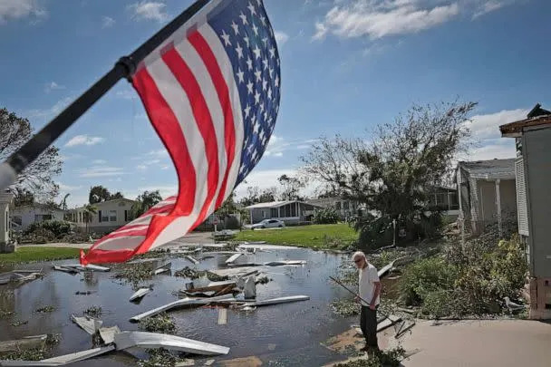
About 35 of Florida’s storm-related deaths have been identified in Lee County, the highest toll anywhere in the state, as survivors describe the sudden surge of water — predicted as a possibility by the National Hurricane Service in the days before the storm hit — that sent some of them scrambling for safety in attics and on rooftops.

Lee County, which includes the hard-hit seaside community of Fort Myers Beach, as well as the towns of Fort Myers, Sanibel and Cape Coral, did not issue a mandatory evacuation order for the areas likely to be hardest hit until Tuesday morning, a day after several neighboring counties had ordered their most vulnerable residents to flee.

By then, some residents recalled that they had little time to evacuate. Dana Ferguson, 33, a medical assistant in Fort Myers, said she had been at work when the first text message appeared on her phone Tuesday morning. By the time she arrived home, it was too late to find anywhere to go, so she hunkered down with her husband and three children to wait as a wall of water began surging through areas of Fort Myers, including some that were well away from the coastline.

“I felt there wasn’t enough time,” she said.

Ferguson said she and her family fled to the second floor, lugging a generator and dry food, as the water rose through their living room. The 6-year-old was in tears.

Kevin Ruane, a Lee County commissioner and a former mayor of Sanibel, said the county had postponed ordering an extensive evacuation because the earlier hurricane modeling had shown the storm heading farther north.

“I think we responded as quickly as we humanly could have,” he said.

Gov. Ron DeSantis and his state emergency management director also said the earlier forecasts had predicted the brunt of the storm’s fury would strike farther north.

“There is a difference between a storm that’s going to hit north Florida that will have peripheral effects on your region, versus one that’s making a direct impact,” DeSantis said at a news conference Friday in Lee County. “And so what I saw in southwest Florida is, as the data changed, they sprung into action.”

But while the track of Hurricane Ian did shift closer to Lee County in the days before it made landfall, the surge risks the county faced — even with the more northerly track — were becoming apparent as early as Sunday night.

At that point, the National Hurricane Center produced modeling showing a chance of a storm surge covering much of Cape Coral and Fort Myers. Parts of Fort Myers Beach, even in that case, had a 40% chance of a 6-foot-high storm surge, according to the surge forecasts.

Lee County’s emergency planning documents had set out a time-is-of-the-essence strategy, noting that the region’s large population and limited road system make it difficult to evacuate the county swiftly. Over years of work, the county has created a phased approach that expands the scope of evacuations in proportion to the certainty of risk. “Severe events may require decisions with little solid information,” the documents say.

The county’s plan proposes an initial evacuation if there is even a 10% chance that a storm surge will go 6 feet above ground level; based on a sliding scale, the plan also calls for an evacuation if there is a 60% chance of a 3-foot storm surge.

Along with the forecasts Sunday night, updated forecasts Monday warned that many areas of Cape Coral and Fort Myers had between a 10% and a 40% chance of a storm surge above 6 feet, with some areas possibly seeing a surge of more than 9 feet.

Over those Monday hours, neighboring Pinellas, Hillsborough, Manatee, Sarasota and Charlotte counties issued evacuation orders, while Sarasota County announced that it expected evacuation orders to be in effect for the following morning. In Lee County, however, officials said they were waiting to make a more up-to-date assessment the following morning.

“Once we have a better grasp on all of that dynamic, we will have a better understanding about what areas we may call for evacuation, and, at the same time, a determination of what shelters will be open,” the Lee County manager, Roger Desjarlais, said Monday afternoon.

But forecasters with the National Hurricane Center were growing more explicit in their warnings for the region. In a 5 p.m. update Monday, they wrote that the highest risk for “life-threatening storm surge” was in the area from Fort Myers to Tampa Bay.

“Residents in these areas should listen to advice given by local officials,” the hurricane center wrote. New modeling showed that some areas along Fort Myers Beach were more likely than not to see a 6-foot surge.

Ruane, the county commissioner, said that one challenge the county faced was that the local schools had been designed to be shelters and that the school board had made the decision to keep them open Monday.

By 7 a.m. Tuesday, Desjarlais announced a partial evacuation order but emphasized that “the areas being evacuated are small” compared with a previous hurricane evacuation.

The county held off on further evacuations, despite a forecast that showed potential surge into areas not covered by the order. Officials expanded their evacuation order later in the morning.

By the middle of the afternoon, Lee County officials were more urgent in their recommendation: “The time to evacuate is now, and the window is closing,” they wrote in a message on Facebook.

Katherine Morong, 32, said she had been prepared earlier in the week to hunker down and ride out the storm based on the guidance from local officials. The sudden evacuation order Tuesday morning left her scrambling, she said, as she set out in her car in the rain.

“The county could have been more proactive and could have given us more time to evacuate,” she said. On the road toward the east side of the state, she said, she was driving through torrents of rain, with tornadoes nearby.

Joe Brosseau, 65, said he did not receive any evacuation notice. As the storm surge began pouring in Wednesday morning, he said, he considered evacuating but realized it was too late.

He climbed up a ladder with his 70-year-old wife and dog to reach a crawl space in his garage. He brought tools in case he needed to break through the roof to escape.

“It was terrifying,” Brosseau said. “It was the absolute scariest thing. Trying to get that dog and my wife up a ladder to the crawl space. And then to spend six hours there.”

Some residents said they had seen the forecasts but decided to remain at home anyway — veterans of many past storms with dire predictions that had not come to pass.

“People were made aware, they were told about the dangers and some people just made the decision that they did not want to leave,” DeSantis said Friday.

Joe Santini, a retired physician assistant, said he would not have fled his home even if there had been an evacuation order issued well before the storm. He said that he had lived in the Fort Myers area most of his life, and that he would not know where else to go.

“I’ve stuck around for every other one,” he said.

The water rushed into his home around dusk Wednesday night, and Friday, there was still a high-water mark about a foot above the floor — leaving Santini a little stunned. “I don’t think it’s ever surged as high as it did,” he said.

Lee County is now an epicenter of devastation, with mass destruction at Fort Myers Beach, the partial collapse of the Sanibel Causeway and entire neighborhoods reduced to rubble. With water mains broken, the county utilities agency has advised residents to boil their water.

President Joe Biden said Friday that the destruction from the storm was likely to be among the worst in U.S. history.

“It’s going to take months, years to rebuild,” he said.

The US Navy said ‘traces’ of jet fuel were found in the water on the aircraft carrier USS Nimitz. A sailor says the problem was way worse.

Business Insider

The US Navy said ‘traces’ of jet fuel were found in the water on the aircraft carrier USS Nimitz. A sailor says the problem was way worse.

Jake Epstein – October 1, 2022

Washing down on the flight deck of the aircraft carrier USS Nimitz
Washing down on the flight deck of the aircraft carrier USS Nimitz.US Navy
  • The US Navy said it found only “traces” of jet fuel in the water on the aircraft carrier USS Nimitz.
  • But a sailor told Insider that they were exposed to an “unhealthy amount” of fuel and shared a photo as evidence.
  • They also said they didn’t immediately receive medical attention, despite health concerns.

The US Navy acknowledged recently that the water the crew of the aircraft carrier USS Nimitz uses to bathe and drink was contaminated by what it described as “traces” of jet fuel, but a sailor on the ship said the situation was worse than the service first let on.

The crew learned about two weeks ago that the water supply had a problem. Specifically, the water had become a troublingly discolored fluid with a bad smell, a sailor said. Testing found what the Navy said were “detectable traces” of hydrocarbons, a chemical component of jet fuel.

In a recent interview with Insider, a sailor aboard the ship described a situation that appears to be far worse than what was initially indicated by the Navy.

“We were exposed to an unhealthy amount of JP-5,” the Nimitz sailor, whose identity is known to Insider but is being withheld due to concerns about the possibility of retribution, said this week. JP-5, or jet-propellant-5, is a kerosene-based fuel that is used in military aircraft and is a go-to for the Navy’s carrier air wings.

Related video: The true cost of the most advanced aircraft carrier, USS Ford

 https://s.yimg.com/rx/martini/builds/49027198/executor.htmlScroll back up to restore default view.

The sailor explained that although they and their shipmates drank and showered with the contaminated water, they were initially denied medical attention for issues that were believed to be related to their exposure to jet fuel.

After earlier Navy assurances there had been no ill effects, a spokesman for 3rd Fleet told Insider on Friday that five sailors have reported health issues that could be related to the contamination and that the ship’s leadership is monitoring the situation. In an overnight update, Insider was informed the number has since risen to 10.

Cmdr. Sean Robertson, a fleet spokesperson, told Insider on Friday that “if we receive any additional reports of potentially contaminated water, we will immediately investigate and take appropriate action to safeguard the crew.” The parents of the sailor Insider spoke with said at that time that the carrier’s medical team was still turning away some sailors.

Discovering jet fuel in the water

The sailor said they were first informed there was jet fuel in the water on the evening of September 16. A Navy spokesperson confirmed this date to Task & Purpose, one of the outlets that along with Navy Times first reported on the problem, and said that the crew “immediately took action.”

The sailor said that the ship’s commanding officer announced to the ship that night that jet fuel had been discovered in the water, stressing that the crew of roughly 3,000 should not drink it and that they should drink only distributed bottled water until they returned to port.

The sailor said that later that night, however, they were told by the ship’s executive officer and the commanding officer that the water was actually safe to drink and that there was nothing to worry about.

“It was not safe to drink,” the sailor said. “People believed the CO and XO, and people were showering in this stuff.”

On the morning of September 17, the aircraft carrier arrived at San Diego’s Naval Air Station North Island, and by noon, the carrier was connected to the local water supply. It wasn’t until that point that the Nimitz leadership reversed course again and said the water was actually unsafe to drink and shower in, the sailor said.

Throughout the night and through the morning, people were under the impression that the water was safe, despite indications that it wasn’t, the sailor said.

“Medical was refusing to see patients or acknowledge that anything going on with patients or different sailors had anything related to the JP-5,” the sailor said, adding that medical staff “refused” to note the JP-5 exposure in sailors’ records.

The Nimitz sailor said that one fellow service member was throwing up while another had a rash. In a separate interview with Insider, the sailor’s parents — whose identities are also known to Insider but are being withheld to protect the sailor — said they noticed their sailor had developed a dry cough after the exposure.

“Medical was telling us that it’ll just pass through you,” the sailor said. They said that after reviewing a safety data sheet, which has information about hazardous chemicals, and cross-referencing their jet fuel exposure, it was clear they should seek medical attention.

Sailors participate in a countermeasure wash down on the flight deck of the aircraft carrier USS Nimitz
Sailors participate in a countermeasure wash down on the flight deck of the aircraft carrier USS Nimitz.US Navy
Testing the water

The sailor explained that when the ship’s water tanks were opened for inspection late on September 17, a “thick layer of JP-5 on top of the potable water” was found. The next step was trying to flush the jet fuel out of the system.

They said that starting the next day on September 18, crewmembers began conducting taste- and smell-tests of the ship’s water — a process that continued for at least the following 10 days and something the sailor described as a “big concern.”

Though Cmdr. Robertson did not say anything about taste testing, he did tell Insider that a “sniffer team” of Nimitz sailors has been tasked with checking out “hot spots,” areas with concerning odors.

The process described by the sailor involved filling and then dumping the water tanks and then sampling the water for jet fuel. In draining the tank, however, they frequently spotted the fuel leaving residue along the sides of the tank.

“So basically what we’re doing is draining the water out, filling it back up, and letting the JP-5 coat the sides of the tank,” the sailor said.

By September 21, the water on the carrier had been laboratory-tested twice.

A Navy official told Insider that an initial test of water samples from September 19 did not “detect measurable amounts of fuel hydrocarbons.” The official said more testing on water samples from the Nimitz’s potable water tanks on September 21, however, did reveal “detectable traces of hydrocarbons.” The Navy did not disclose the specific amount detected.

But the sailor rejected the notion that there were only “traces” of jet fuel, pointing to the “thick layer” of fuel they saw on top of the water in samples.

The aircraft carrier was supposed to depart San Diego late last week, but it ended up staying in port. The sailor speculated that this may have been because of media coverage and attention, which they said is what initially triggered the laboratory tests — not the crew’s suspicion that there was still jet fuel in the water.

To highlight the visible impact of the jet fuel contaminating the water, the sailor’s family provided Insider with a screenshot of a text exchange between the parents and the sailor.

A screenshot of a text exchange with a photo of a sample of what was identified as water from the USS Nimitz contaminated with jet fuel.
A screenshot of a text exchange with a photo of a sample of what a sailor said was water from the USS Nimitz contaminated with jet fuel.Courtesy photo

In the exchange is a photograph, shared with the sailor by a shipmate. The photo was taken shortly after it was first announced that there was jet fuel in the water, the sailor said, and appears to show a water sample — drawn from a water fountain — consisting of a thick, green, layer on the top and a murky, white layer on the bottom.

Working through the aftermath

The sailor said that as of this week, some of their fellow Navy sailors were still drinking and showering with the contaminated water because “we don’t have much of another option.”

The shore water looks clear and has gotten better, they said, but the smell and taste of jet fuel still lingers, as residual amounts continue to stick to the water tanks and piping.

“So the only way we can get all the contamination out of the tank is by completely draining it and scrubbing it, because the way JP-5 sticks to metal,” the sailor said.

Cmdr. Robertson told Insider in an email on Friday that the potable water system on the Nimitz continues to be evaluated so sailors get the “highest quality water” when the ship eventually leaves San Diego.

“The health and well-being of all of our Sailors is our top priority,” he added. “To that end, Nimitz leadership encourages the crew daily to report to medical immediately if they exhibit any illness or injury that could potentially be caused by exposure to contaminated water.”

As of Friday, Robertson said, 10 sailors have reported health issues that “could be associated with JP-5 ingestion, with no new reports in the last 24 hours.”

He said symptoms — which include headache, diarrhea, and rashes — were present between September 17 and September 26. None of those individuals are “currently reporting any symptoms that might be associated with JP-5 ingestion,” he said.

The parents of the sailor with which Insider spoke said in a separate interview that they have been reaching out to various lawmakers to try and voice their concerns, but they haven’t had much luck getting responses.

“Serving this country is a privilege,” one parent said. “But in return, I expect the leadership to support the soldiers and the sailors and to take care of them.”

‘500-year flood’: Florida begins to assess Hurricane Ian’s catastrophic damage

Yahoo! News

‘500-year flood’: Florida begins to assess Hurricane Ian’s catastrophic damage

Dylan Stableford, Senior Writer – September 29, 2022

A day after Hurricane Ian made landfall in southwest Florida as a Category 4 storm, Florida Gov. Ron DeSantis said Thursday that the storm surge that came with it was “basically a 500-year flood event.”

“We’ve never seen a flood event like this,” he said during a news briefing in Tallahassee. “We’ve never seen a storm surge of this magnitude.”

More than 2.5 million people across the state were without power as search and rescue teams and first responders assessed the historic damage.

Motor homes in a flooded area with billowing smoke rising in the background.
Flooded streets in Fort Myers, Fla., on Thursday after Hurricane Ian caused widespread destruction. (Marco Bello/Reuters)

Large sections of the Sanibel Causeway, which connects the Sanibel Islands to the mainland, collapsed into the Gulf of Mexico.

DeSantis said the causeway and Matlacha Pass Bridge are “impassable” and are going to require “structural” rebuilds.

Lee County, which includes Fort Myers, was particularly hard hit. On NBC’s “Today” show, Mayor Kevin Anderson, who has lived in the city since the 1970s, said Ian was “by far the worst storm” he’d ever seen.

Boats damaged by Hurricane Ian are seen in Fort Myers, Fla.
Severely damaged boats in Fort Myers, Fla., amid other debris following the hurricane. (Giorgio Viera/AFP via Getty Images)

And there were conflicting reports of fatalities.

On ABC’s “Good Morning America,” Lee County Sheriff Carmine Marceno said, “While I don’t have confirmed numbers, I definitely know the fatalities are in the hundreds.” DeSantis, though, said that that number was unconfirmed and based on the thousands of people who called to report rising water in their homes.

Later on CNN, Marceno said that there were five confirmed deaths and that “a couple thousand calls came through 911.”

“We got crushed,” he said.

The devastation was seen in other counties too. In Port Charlotte, in Charlotte County, the storm ripped part of a roof off a hospital’s intensive care unit, forcing staff and patients to evacuate to other floors.

A mangled spiral staircase in the brush next to a white pickup truck near the Sanibel Causeway.
A spiral staircase in the brush next to a pickup near the Sanibel Causeway. (Douglas R. Clifford/Tampa Bay Times via AP)

DeSantis said he spoke early Thursday with President Biden, who formally issued a disaster declaration and reaffirmed his commitment to use all available federal resources to assist in rescue and recovery efforts.

Biden was scheduled to receive a briefing on the response efforts at the Federal Emergency Management Agency headquarters in Washington, D.C., Thursday afternoon.

Ian was downgraded to a tropical storm as it cut across the state Thursday morning, but officials warned that conditions remain dangerous.

In Kissimmee, Fla., just south of Orlando, multiple people were rescued from their cars in rising floodwaters. A military transport vehicle was used to bring people and their pets to safety.

In Volusia County, east of Orlando, a 72-year-old man died “after going outside during the storm to drain his pool,” the sheriff’s office said in a Facebook post.

“The initial investigation indicates the victim was using a hose to drain the pool down a hill and into a 30-foot-wide canal, where a steep decline into the water was extremely soft and slippery due to the heavy rain,” the post read. “The Sheriff’s Office sends its sincere condolences to the victim’s family.”

Hurricane Ian could cripple Florida’s home insurance industry

ABC News

Hurricane Ian could cripple Florida’s home insurance industry

Alexis Christoforous – September 29, 2022

Hurricane Ian could cripple Florida’s already-fragile homeowners insurance market. Experts say a major storm like Ian could push some of those insurance companies into insolvency, making it harder for people to collect on claims.

Since January 2020, at least a dozen insurance companies in the state have gone out of business, including six this year alone. Nearly 30 others are on the Florida Office of Insurance Regulation’s “Watch List” because of financial instability.

“Hurricane Ian will test the financial preparedness of some insurers to cover losses to their portfolios, in particular smaller Florida carriers with high exposure concentrations in the impacted areas,” Jeff Waters, an analyst at Moody’s Analytics subsidiary RMS and a meteorologist, told ABC News. Waters said Florida is a peak catastrophe zone for reinsurers, and those with exposure will likely incur meaningful losses.

PHOTO: This aerial photo shows damaged homes and debris in the aftermath of Hurricane Ian, Sept. 29, 2022, in Fort Myers, Fla.  (Wilfredo Lee/AP)
PHOTO: This aerial photo shows damaged homes and debris in the aftermath of Hurricane Ian, Sept. 29, 2022, in Fort Myers, Fla. (Wilfredo Lee/AP)

More than 1 million homes on the Florida Gulf Coast are in the storm’s path, and while Ian’s track and severity can change in the coming days, one early estimate pegs the potential reconstruction cost at $258 billion, according to Corelogic, a property analytics firm.

Industry analysts say years of rampant and frivolous litigation and scams have brought Florida’s home-insurance market to its knees, with many large insurers like Allstate and State Farm, reducing their exposure to the state in the past decade.

MORE: What Hurricane Ian means for food and gas prices

“Insurers most exposed to the storm will be the Florida-only insurers, which we define as insurance companies with at least 75% of their homeowners and commercial property premiums written in Florida,” according to a report from Moody’s Analytics submitted to ABC News.

The state-run, taxpayer-subsidized Citizens Property Insurance Corp. stands to lose the most. As more local insurance companies in Florida have closed their doors, Citizens has seen its number of policyholders swell from 700,000 to more than 1 million in just the past year.

Florida state Sen. Jeff Brandes, a Republican from St. Petersburg and a vocal critic of Florida’s insurance industry, warns that if Citizens can’t pay its claims, Floridians should brace for assessments to go up on their own insurance policies under a state law that allows it to assess non-customers to pay out claims.

“Every policy holder in the state of Florida, home and auto, should be watching this storm very carefully because it could have a direct impact on their pocketbooks,” said Brandes. He predicts policy holders will see rate hikes of up to 40% next year as a result of Ian.

A spokesperson for Citizens tells ABC News that if their preliminary estimate of 225,000 claims and $3.8 billion in losses holds, the insurer of last resort would be in a position to pay all claims without having to levy a “hurricane tax” on residents.

Florida is already home to the highest insurance premiums in the U.S., something Charlie Crist, the former Florida governor running against incumbent Gov. Ron DeSantis, blames on his opponent.

“Gov. DeSantis let these insurance companies double Floridians’ rates and they’re still going belly up when homeowners need them most. You pay and pay and pay, and the insurance company isn’t there for you in the end anyway,” Crist said in a statement Monday.

A spokesperson for DeSantis did not immediately respond to ABC News’ request for comment.

In May, DeSantis signed a bipartisan property insurance reform bill into law that poured $2 billion into a reinsurance relief program and $150 million into a grant program for hurricane retrofitting. Among other things, it prohibits insurance companies from denying coverage based on the age of a roof and limits attorney fees on frivolous claims and lawsuits.

At a news conference Tuesday, DeSantis said a lot of the damage from Ian would be from flooding and storm surge. DeSantis said the danger with the Tampa Bay area is that the water has no place to go, noting that the area has close to 1 million residents enrolled in a national flood insurance program.

PHOTO: A man begins cleaning up after Hurricane Ian moved through the Gulf Coast of Florida on Sept. 29, 2022 in Punta Gorda, Fla. (Win Mcnamee/Getty Images)

Homeowner policies typically do not cover flood damage, and most homeowners located in a flood zone often get coverage from the Federal Emergency Management Agency (FEMA). Most private property insurance companies insure primarily for wind damage.

President Joe Biden on Thursday approved DeSantis’ request for a disaster declaration for a number of counties in the state. It includes grants for temporary housing and home repairs and low-cost loans to cover uninsured property losses.

MORE: Biden coordinates with DeSantis and Fla. officials, warns oil companies as Hurricane Ian hits

“The expense will be higher because of higher construction costs and overall inflation,” Denise Rappmund, the vice president of Moody’s Public Project and Infrastructure Finance Group, told ABC News. “FEMA is the key source of aid following a natural disaster, but much of the costs to repair and rebuild damaged property will be borne by property insurers who will benefit from $2 billion of state-funded reinsurance.”

Analysts say Hurricane Ian has the potential to be among the four costliest storms in U.S. history, mostly because Florida’s population has exploded in recent years.

No state in the eastern U.S. has grown faster in population than Florida in the past decade and the state’s fastest growing cities: Tampa, Fort Myers and Sarasota, are all in the storm’s path. Analysts warn that more people and more homes mean that a major storm could become more destructive and costly.

What is the healthiest fish to eat? What fish should I avoid?

USA Today

What is the healthiest fish to eat? What fish should I avoid?

Jacob Livesay, USA TODAY – September 28, 2022

Fish is generally a healthy food high in omega-3 fatty acids, which our bodies do not naturally produce, according to Healthline.

In addition to protein content, the American Heart Association says eating fish twice per week can also lead to better cardiovascular health.

But not all fish are equal. Some are much healthier than others, and there are also considerable environmental concerns related to contaminants like mercury and polychlorinated biphenyls.

Here are the best fish to include in your diet, as well as some to avoid.

What is sugar alcohol?: The reduced-calorie sweetener you might not recognize.– ADVERTISEMENT -https://s.yimg.com/rq/darla/4-10-1/html/r-sf-flx.html

How to keep your cholesterol down: Foods, normal readings and more.

What is the healthiest fish to eat?

These are some of the healthiest fish for your diet, according to Healthline — though read further for more details on how to ensure you’re not contributing negatively to the environment:

  • Alaskan salmon
  • Cod
  • Herring
  • Mahi-mahi
  • Mackerel (other than king mackerel)
  • Perch
  • Rainbow trout
  • Sardines
  • Striped bass
  • Tuna (other than bluefin and bigeye tuna), especially canned light tuna
  • Wild Alaskan pollock
  • Arctic char

What foods are high in iron? Here’s some healthy, iron-rich options to add to your diet.

What are the worst fish to eat?

The worst fish to eat are those high in mercury, according to WebMD. Avoid these fish for that reason:

  • Imported swordfish
  • Imported marlin
  • Shark
  • Tilefish
  • King mackerel
  • Orange roughy

Some types of tuna, such as bluefin and bigeye tuna, may also be more likely to have higher levels of mercury, according to WebMD.

How to lower your blood pressure: Tips include limiting alcohol and table salt

What are the best fish to eat for the environment?

It’s important to think about sustainability, as well as the health implications of consuming fish with contaminants such as mercury or polychlorinated biphenyls. Fish healthy to eat and having minimal environmental impact, according to One Medical:

  • Troll-caught or pole-caught albacore tuna from the U.S. or British Columbia
  • Wild-caught salmon from Alaska
  • Farmed oysters
  • Wild-caught sardines from the Pacific Ocean
  • Farmed rainbow trout
  • Tank-farmed freshwater coho salmon from the U.S.

Cuba without electricity after hurricane hammers power grid

Associated Press

Cuba without electricity after hurricane hammers power grid

Andrea Rodriguez – September 27, 2022

A classic American car drives past utility poles tilted by Hurricane Ian in Pinar del Rio, Cuba, Tuesday, Sept. 27, 2022. (AP Photo/Ramon Espinosa)
Men lead their ox cart past a tobacco warehouse smashed by Hurricane Ian in Pinar del Rio, Cuba, Tuesday, Sept. 27, 2022. Hurricane Ian tore into western Cuba as a major hurricane and left 1 million people without electricity, then churned on a collision course with Florida over warm Gulf waters amid expectations it would strengthen into a catastrophic Category 4 storm. (AP Photo/Ramon Espinosa)
Maria Llonch retrieves her belongings from her home damaged by Hurricane Ian in Pinar del Rio, Cuba, Tuesday, Sept. 27, 2022. (AP Photo/Ramon Espinosa)
Mercedes Valdez holds her dog Kira as she waits for transportation after losing her home to Hurricane Ian in Pinar del Rio, Cuba, Tuesday, Sept. 27, 2022. (AP Photo/Ramon Espinosa)

HAVANA (AP) — Hurricane Ian knocked out power across all of Cuba and devastated some of the country’s most important tobacco farms when it slammed into the island’s western tip as a major hurricane Tuesday.

Cuba’s Electric Union said in a statement that work was underway to gradually restore service to the country’s 11 million people during the night. Power was initially knocked out to about 1 million people in Cuba’s western provinces, but later the entire grid collapsed.

Ian hit a Cuba that has been struggling with an economic crisis and has faced frequent power outages in recent months. It made landfall as a Category 3 storm on the island’s western end, devastating Pinar del Río province, where much of the tobacco used for Cuba’s iconic cigars is grown.

Tens of thousands of people were evacuated and others fled the area ahead of the arrival of Ian, which caused flooding, damaged houses and toppled trees. Authorities were still assessing the damage, although no fatalities had been reported by Tuesday night.

Ian’s winds damaged one of Cuba’s most important tobacco farms in La Robaina.

“It was apocalyptic, a real disaster,” said Hirochi Robaina, owner of the farm that bears his name and that his grandfather made known internationally.

Robaina, also the owner of the Finca Robaina cigar producer, posted photos on social media of wood-and-thatch roofs smashed to the ground, greenhouses in rubble and wagons overturned.

State media said Cuban President Miguel Díaz-Canel visited the affected region.

Cuba’s Meteorology Institute said the city of Pinar del Río was in the heart of the hurricane for an hour and a half.

“Being in the hurricane was terrible for me, but we are here alive,” said Pinar del Rio resident Yusimí Palacios, who asked authorities for a roof and a mattress.

Officials had set up 55 shelters and took steps to protect crops, especially tobacco.

The U.S. National Hurricane Center said Cuba suffered “significant wind and storm surge impacts” when the hurricane struck with top sustained winds of 125 mph (205 kph).

Ian was expected to get even stronger over the warm Gulf of Mexico, reaching top winds of 130 mph (209 kph) approaching the southwestern coast of Florida, where 2.5 million people were ordered to evacuate.

As the storm’s center moved into the Gulf, scenes of destruction emerged in Cuba. Authorities were still assessing the damage in its world-famous tobacco belt.

Local government station TelePinar reported heavy damage at the main hospital in Pinar del Rio city, tweeting photos of collapsed ceilings and downed trees. No deaths were reported.

Videos on social media showed downed power lines and cut off roads in the provinces of Pinar del Rio, Artemisa and Mayabeque. A hospital in Pinar del Río was damaged.

“The town is flooded,” said farmer Andy Muñoz, 37, who lives in Playa Cajío in Artemisa.

He said many people lost their belongings due to the storm surge.

“I spent the hurricane at home with my husband and the dog. The masonry and zinc roof of the house had just been installed. But the storm tore it down,” said Mercedes Valdés, who lives along the highway connecting Pinar del Río to San Juan y Martínez. “We couldn’t rescue our things … we just ran out.”

AP journalist Osvaldo Angulo in Pinar del Rio contributed to this report.

California’s water usage was built on a historic lie. The cost is now apparent

Los Angeles Times

Column: California’s water usage was built on a historic lie. The cost is now apparent

Michael Hiltzik – September 21, 2022

LAKE MEAD, NEV. - JUNE 11, 2021. A motorhome travels across the Hoover Dam near Boulder City, Nev. A white "bathtub ring" above the dam hows how far below capacity Lake Mead - the nation's largest reservoir - currently is. Water levels at Lake Mead have hit their lowest points in history amid an ongoing megadrought, creating uncertainty about the water supply for millions of people in the western United States. (Luis Sinco / Los Angeles Times)
The water intakes of Hoover Dam on Lake Mead, and the “bathtub ring” behind them, show how far below its historical level the vast reservoir has fallen. (Luis Sinco / Los Angeles Times)

It’s human nature to mark big-number anniversaries, but there’s a centennial looming just ahead that Californians — and other Westerners — might not want to celebrate.

It’s the 100th anniversary of the Colorado River Compact, a seven-state agreement that was signed Nov. 24, 1922.

That evening, in the Ben Hur Room of Santa Fe’s Palace of the Governors, using the lapboard on which Gen. Lew Wallace had written his biblical epic 40 years earlier while serving as New Mexico’s territorial governor, representatives of six of the seven states of the Colorado River Basin applied their signatures to the compact with a gold pen.

If we had cut water use in the Colorado River over the last two decades to what we now understand to be the actual levels of water availability … the crisis wouldn’t be nearly as bad.

Peter Gleick, Pacific Institute co-founder

The compact — essentially an interstate treaty — set the rules for apportioning the waters of the river. It was a crucial step in construction of Hoover Dam, which could not have been built without the states’ assent.

The compact stands as a landmark in the development of Los Angeles, San Diego, Denver, Phoenix and other Western metropolises. But it is also a symbol of the folly of unwarranted expectations.

That’s because the compact was built on a lie about the capacity of the Colorado River to serve the interests of the Western states — a lie that Westerners will be grappling with for decades to come.

The crisis of water supply from the Colorado is vividly represented by the so-called bathtub ring around Lake Mead, the vast reservoir behind Hoover Dam, showing how far below normal the water level has fallen.

As my colleague Ian James has reported, federal projections show that the risk is growing that both Lake Mead and Lake Powell, the reservoir behind Glen Canyon Dam, are approaching “dead pool” levels, below which water would no longer pass downstream through the dams.

The prospect has led to pressure from the federal government on water agencies in California and the six other basin states to drastically cut back on water use. So far, however, no agreements on cutbacks have emerged.

The ultimate danger is that Lake Mead reaches the “dead pool” stage. At the end of last month, Lake Mead was at 1,044.28 feet of surface elevation above sea level. That’s about 100 feet below its level in August 2003 and about 180 feet below its record elevation of 1,225 feet, reached in July 1983. When the level falls to 950 feet, the lake can no longer generate hydroelectricity. At 895 feet, the dam can’t release water downstream.

The long-term decline in Lake Mead’s capacity has been blamed mostly on global warming. But as I’ve reported before, the river’s enemies are both natural and man-made. It’s true that nature has placed the basin in a long-term drought. But human demands for water from the Colorado have far outstripped what it can provide — indeed, what it ever could provide.

That brings us back to the compact negotiations. The impulse for a high dam on the lower Colorado came largely from California — principally from growers in the Imperial Valley. They depended on the river for irrigation and desired a more reliable supply as well as flood control that could only be provided by a major dam.

Congress resisted approving the project unless the seven basin states of California, Nevada, Arizona, New Mexico, Colorado, Utah and Wyoming could agree on how to apportion the river among themselves.

basin
The Colorado River basin encompasses seven states. The All-American Canal, at lower left, serves California’s Imperial Valley. Lees Ferry, Ariz., at center, marks the division between the upper basin states of Wyoming, Utah, Colorado and New Mexico, and the lower basin of California, Nevada and Arizona. (U.S. Geological Survey)

The task of supervising the negotiations fell to Herbert Hoover, who was President Harding’s Commerce secretary. The process was contentious. The upstream states were painfully aware that California was the most voracious user of the river’s water even though it had the smallest acreage within the basin.

All were convinced that California, the most-developed state of the seven, was plotting to appropriate more than its share of the water to stoke its continued development at their expense. They were suspicious of Hoover, who though born in Iowa had made his home in California since becoming a member of the first graduating class at Stanford University in 1895.

Working with his deputy, Arthur Powell Davis — director of the U.S. Reclamation Bureau and a nephew of John Wesley Powell, the pioneering explorer of the Colorado and the Grand Canyon — Hoover overcame the states’ disagreements by promising that they all would receive enough water to provide for all their future economic growth.

They did this through connivance. Davis provided an estimate that the river’s annual volume averaged 16.4 million acre-feet. (One acre-foot, the equivalent of 325,851 gallons, is enough water to serve one or two average households today.)

That allowed the compact to be concluded with a guarantee that the upper basin states of Wyoming, Utah, Colorado and New Mexico could pass 7.5 million acre feet a year — measured as 10-year averages of 75 million acre-feet — to the lower states of California, Nevada and Arizona without sacrificing their own needs. All the states agreed on this formula except Arizona, which didn’t sign the compact until 1944.

(By then the state had all but gone to war with California over water rights on the river, dispatching a squad of National Guard troops to the river on a ferryboat to block construction of Parker Dam in 1934. The ferry was derisively dubbed the “Arizona navy” by a Times correspondent assigned to cover the skirmish. After the federal government imposed a truce, the guardsmen were reported to have returned home from the “war zone” as “conquering heroes.”)

The real flaw in the compact was no joke, however: Davis’ figure was a flagrant overestimate — as he certainly knew, having studied the Colorado for decades.

The 1899-1921 time span on which his figure was based was one of the wettest periods in the basin’s known history. Indeed, only four times since construction of Hoover Dam began in 1931 has the 10-year average reached 16.4 million acre-feet.

Current estimates place the average annual volume of the Colorado since 1906 at 14.7 million acre-feet; since 1991, the annual average is closer to 13.5 million.

Yet the portions of California and the West dependent on the river for their sustenance have grown as if its bounty is effectively limitless.

In 1935, President Franklin Roosevelt dedicated the dam from a podium overlooking the project, declaring that it had turned the willful river into “a great national possession.” Since that time, the population of the seven basin states has grown by more than 52 million, much of the growth fueled by the water and electricity the dam has provided.

For several decades, however, climate and hydrological experts have warned that there can be no soft landing from the restrictions that global warming are forcing upon the Colorado River’s historical beneficiaries.

Hard choices are becoming imperative. The federal government is effectively ordering that the basin states cut their water usage by 2 million to 4 million acre-feet a year.

Talk of draining Lake Powell to keep water in Lake Mead at a serviceable level is getting louder, notwithstanding the political and engineering obstacles standing in the way. Within basin states, especially California, water scarcity is exacerbating conflicts among growers, residential users and environmentalists.

The draconian cutbacks signaled by the federal government have been made necessary by inadequate action in the recent past.

As water and climate expert Peter Gleick told James recently, “If we had cut water use in the Colorado River over the last two decades to what we now understand to be the actual levels of water availability, there would be more water in the reservoirs today,” Gleick said. “The crisis wouldn’t be nearly as bad.”

The reckoning may have been long in coming, but it was inevitable. As long ago as 1893, John Wesley Powell — the uncle of Arthur Powell Davis, who perpetrated the foundational lie allowing the construction of Hoover Dam — foresaw the basin’s destiny.

Attending an irrigation congress in Los Angeles at which the coming paradise of water-driven growth was being proclaimed, Powell stood to deliver a hard truth. “I tell you, gentlemen,” he said, “you are piling up a heritage of conflict and litigation over water rights, for there is not sufficient water to supply the land.”

He was driven from the hall by a chorus of catcalls and boos, but time has proved him right.

Climate change could wipe $108 billion from U.S. property market, study finds

NBC News

Climate change could wipe $108 billion from U.S. property market, study finds

Alex Lubben – September 20, 2022

Sea level rise will flood huge swaths of the country and submerge billions of dollars’ worth of land, according to a new report.

An analysis from Climate Central, a nonprofit research group, put a price tag on just how much all that land is worth — and how much local governments stand to lose when it goes underwater. The report found that nearly 650,000 privately owned parcels of land over more than 4 million acres will fall below tide lines within the next 30 years. The analysis indicates that sea level rise could reduce the value of that private land by more than $108 billion by the end of the century.

Because all land below the tide line is, by law, state-owned, the encroachment of the tides could essentially vaporize huge amounts of private, taxable wealth. That, in turn, will decrease property tax revenue substantially in coastal areas, which experts caution could ultimately bankrupt local governments.

For millennia, tide lines haven’t really budged. Nor has the notion that any land under water is public, which is an “idea that goes way back to Roman times,” said Peter Byrne, the director of the Georgetown Environmental Law and Policy Program. “The tidelands, the sea, they’re open to the public because they’re navigable. They’re inherently public.”

But as the planet heats, the old tide lines are climbing uphill. The study found that an area the size of the state of New Jersey that is now above water will be submerged at high tide in 2050.

“Sea level rise is ultimately going to take land away from people,” said Don Bain, a senior adviser with Climate Central, who wrote the report. “That’s something we haven’t come to grips with.”

Losing such a huge amount of private land over a few years could have far-reaching consequences. Insurance companies have already started to pull out of coastal markets or are raising their premiums substantially. Banks and other financial institutions are starting to look at whether it makes sense to lend to homeowners and businesses along the coastline.

All told, places that are currently livable will become increasingly hard to live in. Here’s what this might mean for local governments.

Risk isn’t evenly distributed

Climate Central found that, unsurprisingly, the effects of sea level rise aren’t evenly distributed across the U.S. The Atlantic and Gulf Coasts will feel its effects more than other parts of the country. In many areas along the coast, sea levels will rise significantly faster because land is sinking as sea levels rise.

By 2050, Climate Central estimates that about 75% of Terrebonne Parish, Louisiana, will be underwater. In Hudson County, New Jersey, $2.4 billion worth of taxable property will be submerged. In Galveston County, Texas, more than 4,200 buildings that are currently above sea level will be at least partially underwater.

Kyle Harner kayaks along a flooded street in Friendswood, Texas, on Sept. 22, 2020.  (Stuart Villanueva / The Galveston County Daily News via AP file)
Kyle Harner kayaks along a flooded street in Friendswood, Texas, on Sept. 22, 2020. (Stuart Villanueva / The Galveston County Daily News via AP file)

“Climate impacts are not going to happen far off into the future, but within the life of the mortgage on your house,” said Anna Weber, a policy analyst with the National Resources Defense Council.

While sea level rise is one of the major impacts of the climate crisis, it’s not the only one. Supercharged hurricanes and wildfires will also cause displacement and will contribute to the erosion of local tax bases as people move to safer areas. More frequent intense rainstorms are expected to cause more inland flooding in many parts of the U.S. Coastal counties won’t be the only places affected.

“These numbers are relatively conservative,” said Jesse Keenan, a professor of sustainable architecture at Tulane University, who was not involved with the Climate Central study. “That’s what should scare people.”

Doing more with less

In many places, coastal property is the most valuable real estate — and a major source of property taxes for local governments. Without it, municipalities could see a huge loss of revenue at a time when the costs of adapting to climate change are expected to skyrocket. The costly measures that municipalities will need to undertake to adapt to rising sea levels, like building seawalls or elevating roads, could become more difficult to fund.

“When that property tax revenue base shrinks, it’s a compounding problem for adaptation,” said A.R. Siders, a climate adaptation researcher at the University of Delaware’s Disaster Research Center. That could create a vicious cycle: “Not being able to protect those homes reduces their value and so you have fewer resources to protect those homes.”

That won’t just affect the owners of beachfront property. Municipalities rely on property taxes to fund roads, schools, trash pickup — all the basic services that residents rely on.

“It seems probable to me that over time we’re going to have to figure out a different funding model for really flood-prone communities, or communities along the coastline,” Siders added. “They’ve been relying on the perpetual growth of the housing market and that just doesn’t deem realistic in places that are going to experience the effects of climate change.”

One tool that municipalities use to raise money to fund projects that make them more resilient to climate change is municipal bonds — to do things like build a new bridge, fund the construction of a school, or, maybe, to pay for flood control so a city doesn’t get submerged by the next big storm.

Huge Snow Storm Slams Into Mid Atlantic States (Andrew Renneisen / Getty Images file)

Flooding poses threats to crops, commuting routes, utilities, wastewater treatment plants and buildings, the report noted. How local governments react to these economic hits will have implications for their ability to repay debt and keep their credit ratings afloat.

“Before they even reach bankruptcy, stress is going to reverberate through the muni bond market,” Keenan said. “What we’ll begin to see is a more explicit [climate] premium and a higher cost of borrowing for these counties.”

‘Choices to be made’

There are parts of the country that are exacerbating their exposure to the climate risks by continuing to build in coastal areas that will soon be underwater. Climate Central’s report calls for stricter restrictions on new developments and for building new housing outside of risk zones.

Buyouts, in which the government offers to purchase flood-prone buildings, could help create a natural “buffer zone” along the coasts, other experts suggest.

“This issue of losing tax base is something that comes up a lot when we talk about home buyouts because in that case, you are deliberately converting a property from private ownership to public ownership,” Weber said. “What this report shows is that, in some cases, that process is going to happen whether you do it deliberately or not.”

Besides building codes and moving people out of harm’s way, there’s still time to change course on greenhouse gas emissions, Bain emphasized. If the world continues to produce emissions at the current rate, the tides will rise faster; reducing emissions now will allow crucial time to adapt to the rising tides.

“We may not be able to change much between now and 2050, but we can make a large difference going forward from that,” Bain said. “There are still choices to be made — between better outcomes and far worse outcomes.”

8 million ordered to evacuate as Typhoon Nanmadol slams across Japan: ‘Raining like never before’

USA Today

8 million ordered to evacuate as Typhoon Nanmadol slams across Japan: ‘Raining like never before’

John Bacon, USA TODAY – September 19, 2022

More than 8 million people in southern and western Japan have been ordered to evacuate as Typhoon Nanmadol roars across the island nation with historic wind and waves.

Local government officials across Japan told national broadcaster NHK that a level 5 alert, the highest on Japan’s disaster warning scale, was issued to more than 330,000 people in about 160,000 households in Kagoshima, Miyazaki and Oita prefectures.

Nearly 8 million people in about 3.7 million households affected by a level 4 alert were ordered to evacuate in parts of the Kyushu, Shikoku and Chugoku regions, NHK said.

The Japan Meteorological Agency said it was “raining like never before” in Miyazaki, where some areas saw more than 15 inches of rain in the 24 hours through Sunday afternoon. Power lines tumbled and hundreds of thousands of homes and businesses were dark as the storm slowly rolled northward over Kyushu.

“To protect your life and the lives of your loved ones, please follow the evacuation information already issued by your local municipality immediately,” the agency said. “Ensure your own safety without waiting for the announcement of a special warning.”

First special typhoon warning

In Kagoshima, thousands took shelter at evacuation centers. Wind speeds of almost 115 mph were reported in parts of the region.

It was the first time the agency has issued a special typhoon warning for an area outside from Okinawa Prefecture. Flights were canceled and train service, the lifeblood of Japanese travel, was suspended in the region.

Prime Minister Fumio Kishida said he had mobilized police, firefighters, the Self-Defense Forces and other agencies.

‘ANGRY SEA’: Huge storm floods roads, homes in Alaska as governor declares disaster

“I urge (the public) to avoid going near places posing potential dangers such as rivers and other waterways or places at risk of landslides, and to evacuate without hesitation if they feel in danger in any way,” Kishida said.

Earthquake strikes Taiwan

Less than 900 miles southwest of Japan’s natural disaster, a strong earthquake struck southeastern Taiwan on Saturday evening, collapsing a house and interrupting rail service on the island. Taiwan’s Central News Agency said the 6.4 magnitude shallow quake was centered north of Taitung County on the island’s eastern shore.

STRONG EARTHQUAKE HITS TAIWAN: Rail service disrupted, house topples

Contributing: The Associated Press

Bill Clinton: ‘The world’s on fire,’ but teamwork can help

Associated Press

Bill Clinton: ‘The world’s on fire,’ but teamwork can help

Glenn Gamboa – September 19, 2022

NEW YORK (AP) — Former President Bill Clinton is calling on governments, businesses, philanthropies and other prominent institutions to draw together and help a world that is “on fire” as he reconvenes the Clinton Global Initiative, the meeting of international leaders, for the first time since 2016.

“Somebody needs to show up and make something good happen,” he said during the conference’s opening public session Monday. “That’s what we’re trying to do.”

Interest in the two-day meeting has been so intense that the Clinton Foundation had to turn away more than 1,000 potential attendees. It is convening a spectrum of luminaries, including Jordan’s Queen Rania Al Abdullah, Barbados Prime Minister Mia Mottley, BlackRock CEO Larry Fink, Nobel Peace Prize winner Malala Yousafzai and actor and water access activist Matt Damon.

Clinton, president of the United States from 1993 to 2001, said he has been amazed by the massive response.

“The world’s on fire in a lot of different ways,” he told The Associated Press in an interview. “But there are a lot of things that businesses, non-governmental groups and governments working together can do to help with a lot of these problems.”

The Clinton Global Initiative, or CGI, has helped more than 435 million people in more than 180 countries since it was established in 2005. It previously required attendees to create a Commitment to Action, a measurable project that addresses a global issue, though for this first year, everyone will be expected to announce or develop a partnership. Those commitments often unite new partners and encourage cooperation between the public and private sectors.

“I think there is a longing for people to get together and meet with an end in mind,” Clinton said in an interview. “Not just talk about it, but knowing that when they walk away, they will have committed to doing something.”

Clinton Foundation Vice Chair Chelsea Clinton calls that “a bias toward action,” which she says is part of what makes CGI special and a catalyst for global change. She said the COVID-19 pandemic has energized interest in public health and addressing health disparities because people outside of the field could see the impact.

“Health is interconnected to anything and everything that anyone may care about,” Chelsea Clinton said. “There are a lot of people who now are mobilized to do something with what they have come to newly understand and which they now feel responsible for helping to solve.”

Dr. David Fajgenbaum received a standing ovation as he announced plans for his new nonprofit Every Cure, which seeks to find new uses for generic drugs to treat rare diseases. The idea came from his own research to find a treatment for his own Castleman’s Disease, a rare ailment where the immune system attacks vital organs.

He said his new nonprofit would work on using generic drugs to treat 106 rare disease initially, a process that would cost 500 times less than developing a new drug. “There would be no greater impact in terms of saving lives,” he said. “As long as I’m alive, we’re going to continue to chase them.”

In other commitments, Andrew Kuper, founder and CEO of impact investing firm LeapFrog Investments, announced the firm planned to support 25 million enterprises offering 100 million jobs in developing countries by 2030. Israeli global venture firm OurCrowd announced a partnership with the WHO Foundation to launch a $200 million Global Health Equity Fund that focuses on breakthrough technology solutions in health care.

Peter Sands, executive director of The Global Fund to Fight AIDS, Tuberculosis and Malaria, said CGI has always introduced his group to new potential partners, something even more valuable after two challenging pandemic years that made access to new donors difficult. “There’s only so much you can do with PowerPoints and Zooms,” Sands said.

He is currently in the midst of a fundraising campaign of his own. President Joe Biden will host The Global Fund’s Seventh Replenishment Conference in New York on Wednesday, delayed two days so that Biden can attend the funeral of Queen Elizabeth II on Monday.

However, he now plans to attend CGI and said the gathering has been missed during its hiatus, even though the Clinton Foundation itself has remained active. The initiative convened annually until 2016 during former Sen. Hillary Clinton’s presidential campaign, when questions were raised about the appearance of potential conflicts of interests if donors then had business before her administration.

Bill Clinton said the initiative is counting on the special energy of its participants to tackle a growing number of issues.

“We’ve got the largest number of migrants since World War II,” he said. “And the most publicity they get in America is when one governor or two turns it into some political issue and tries to make problems for other people. Sensible countries work together and try to figure out the best way to deal with it.”

Clinton also hopes CGI can spotlight various solutions that need more support. He points to a study from Generation180, a nonprofit that promotes the use of clean energy. Its research shows some rural schools have installed solar panels to reduce their carbon emissions and their electric bills. The schools then used the savings to give raises to teachers.

“The energy is here. The jobs are here. The benefits are here. The kids win,” Clinton said. “That shouldn’t be a political issue.”

He says philanthropy can help bust through political and cultural gridlock by showing what can be done. For example, he said that when President Barack Obama proposed hiring 100,000 new STEM teachers and Congress turned him down, philanthropy stepped in to make it happen.

“We got the Carnegie Corporation and the American Federation of Teachers and more than 20 other partners together and they said, ‘We will raise the money,'” Clinton said. “Nobody ever thought of that as being a purpose of philanthropy. But it got the job done, and it demonstrated why Republicans and Democrats should cooperate on such things.”

Associated Press coverage of philanthropy and nonprofits receives support through the AP’s collaboration with The Conversation US, with funding from Lilly Endowment Inc. The AP is solely responsible for this content. For all of AP’s philanthropy coverage, visit https://apnews.com/hub/philanthropy.