Drought emergency declared for all Southern California
Hayley Smith, Ian James – December 14, 2022
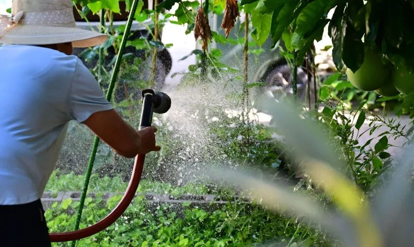
A woman waters her garden in Los Angeles in August. (Frederic J. Brown / AFP via Getty Images)
As California faces the prospect of a fourth consecutive dry year, officials with the Metropolitan Water District of Southern California have declared a regional drought emergency and called on water agencies to immediately reduce their use of all imported supplies.
The decision from the MWD’s board came about eight months after officials declared a similar emergency for 7 million people who are dependent on supplies from the State Water Project, a vast network of reservoirs, canals and dams that convey water from Northern California. Residents reliant on California’s other major supply — the Colorado River — had not been included in that emergency declaration.
“Conditions on the Colorado River are growing increasingly dire,” MWD Chairwoman Gloria Gray said in a statement. “We simply cannot continue turning to that source to make up the difference in our limited state supplies. In addition, three years of California drought are drawing down our local storage.”
Officials said the call for conservation in Colorado River-dependent areas could become mandatory if drought conditions persist in the coming months, which some experts say is likely. By April, the MWD will consider allocating supplies to all of its 26 member agencies, requiring them to either cut their use of imported water or face steep additional fees. The agencies together serve about 19 million people.
“Since this drought began, we have been steadily increasing our call for conservation. If we don’t have an extremely wet winter, we will need to elevate to our highest level — a water supply allocation for all of Southern California,” said MWD General Manager Adel Hagekhalil. “Substantial and immediate conservation now and in the coming months will help lessen the potential severity of such an allocation.”
MWD member agencies, which include the Los Angeles Department of Water and Power, the Municipal Water District of Orange County and the Inland Empire Utilities Agency, will implement voluntary and mandatory conservation measures at the local level based on their particular circumstances, officials said. Those with local supplies or other alternative options may be able to rely on them in the interim.
The DWP, which imports state and federal water as well as water from the Owens Valley via the Los Angeles Aqueduct, has been under Level 3 of its water shortage contingency plan since June, including two-day-a-week outdoor watering limitations.
During a board meeting Tuesday, DWP senior assistant general manager Anselmo Collins said MWD’s decision was “setting the stage” for the entire region to see similar rules should the Colorado order become mandatory.
“We already have a budget that’s been given to us, so to us [in Los Angeles] it’s probably not going to be any different,” he told the board. “It is going to be for the other 20 member agencies that are currently not under a water supply allocation. … They would too be put on some kind of volumetric budget, or one-day-a-week requirement.”
About half of the MWD’s imported water comes from the State Water Project and half from the Colorado River — both of which have become “extraordinarily stressed by prolonged drought exacerbated by climate change,” the agency said.
The Colorado River has fallen to such historic lows that Lake Mead and Lake Powell — the nation’s two largest reservoirs — could reach “dead pool”, or the point at which water no longer passes downstream from a dam. California and six other states that rely on the river have been under pressure from the federal government to drastically reduce their use.
In October, some California water agencies, including the MWD, pledged usage reductions of up to 400,000 acre-feet per year, or about 9% of the state’s total 4.4 million water allotment from the river, through 2026. Still, other states are demanding that California do more to cut usage.
The drought emergency declaration came as representatives of the MWD and other water districts gathered in Las Vegas with officials from all seven states, the federal government and tribes for the annual conference of the Colorado River Water Users Assn. Attendees are discussing various issues about how the river is managed, including measures to address the severe shortage.
“It’s a good step for sure,” conference attendee Daryl Vigil, water administrator of the Jicarilla Apache Nation in New Mexico, said of the MWD’s declaration.
The willingness of the district’s officials to “take part in mitigating the risk in terms of reduction in use is really big coming from California,” Vigil said. “And hopefully others will follow suit.”
Scott Houston, vice president of the West Basin Municipal Water District, a wholesale supplier for nearly 1 million people in 17 cities and unincorporated areas in Los Angeles County, said the move is necessary.
“We are in a critical time with the Colorado River,” Houston said. “This is a very serious situation, as we’ve seen the conditions escalate over the last few months. This is an all-hands-on-deck moment.”
The State Water Project has been under similar strain. The driest three water years on record in California resulted in record-low deliveries to Southern California, and earlier this month, state officials said they may allocate only 5% of requested supplies next year if drought conditions do not significantly improve.
Madelyn Glickfeld, co-director of the UCLA Water Resources Group, said the MWD’s decision was a “warning shot” for what could lie ahead — and a reminder of how important it is for communities to invest in alternative supplies such as recycled water and, in some cases, groundwater and desalination.
“We’ve been working hard toward this, but I don’t think anyone expected — or they didn’t look carefully enough — to expect that this was going to happen right now,” she said. “There were a lot of places where people could have taken the warning before now, but they have not.”
The MWD underscored that it has been making big investments in sustainable local supplies for the region, including the development of what could be one of the world’s largest recycled water facilities, Pure Water Southern California.
But many such projects are years if not decades away, and action is critical now, Glickfeld said. For the time being, conservation and “a complete transition in the way we do landscaping” are among the region’s best bets.
Indeed, many agencies, including the DWP and the West Basin Municipal District, have been offering rebates for residents to replace their grass with drought-resilient landscaping.
“One of the biggest areas where we use water is outdoor irrigation,” Houston said. “That’s really one of the best tools in our toolbox right now to reduce the need for some of that imported water.”
As officials continue to weigh their options for the Colorado River, the mandatory measures in State Water Project-dependent areas will continue through at least June and possibly longer, the MWD said.
“Some Southern Californians may have felt somewhat protected from these extreme conditions over the past few years,” Gray said. “They shouldn’t anymore. We are all affected.”
Nation’s largest water supplier declares drought emergency
December 14, 2022
FILE – A sprinkler waters the lawn of a home on Wednesday, May 18, 2016, in Santa Ana, Calif. T On Tuesday, Dec. 13, 2022, the Metropolitan Water District declared a regional drought emergency for all of Southern California. (AP Photo/Jae C. Hong, File) (ASSOCIATED PRESS)
LOS ANGELES (AP) — The nation’s largest water supplier has declared a drought emergency for all of Southern California, clearing the way for potential mandatory water restrictions early next year that could impact 19 million people.
The Metropolitan Water District of Southern California provides water to 26 different agencies that supply major population centers like Los Angeles and San Diego counties.
It doesn’t rain much in Southern California, so the district imports about half of its water from the Colorado River and the northern Sierra Nevada via the State Water Project — a complex system of dams, canals and reservoirs that provides drinking water for much of the state.
It’s been so dry the past three years that those water deliveries have hit record lows. Earlier this year, the district declared a drought emergency for the agencies that mostly depend on the State Water Project, which covers about 7 million people.
On Tuesday, the board voted to extended that declaration to cover all Southern California water agencies. They called on agencies to immediately reduce how much water they import. By April, the board will decide whether to make those cuts mandatory if the drought continues.
“Some Southern Californians may have felt somewhat protected from these extreme conditions over the past few years. They shouldn’t anymore. We are all affected,” said Gloria D. Gray, chair of the Metropolitan Water District’s Board.
State officials recently announced that water agencies like Metropolitan will only get 5% of their requested supplies for the start of 2023 due to lower reservoir levels. Some agencies may get a little bit more if its necessary for drinking, sanitation or other health and safety concerns.
The drought declaration comes as Colorado River water managers are meeting in Las Vegas to discuss growing concerns about the river’s future after more than two decades of drought. Scientists say climate change has contributed to sustained warmer and drier weather in the West, threatening water supplies. The river’s two largest reservoirs — Lake Mead on the Nevada-Arizona state line and Lake Powell on the Arizona-Utah border — are each about one-quarter full.
In California, despite a recent run of storms that have dumped heavy rain and snow in the Sierra Nevada and Central Valley, reservoirs are all well below average for this time of year.
“I think Metropolitan is being very proactive in doing this,” said Dave Eggerton, executive director of the Association of California Water Agencies. “It’s really the right thing to do.”
Up to 75% of all water used in Southern California is for irrigating yards and gardens. Water agencies dependent upon imported water from the state have had restrictions for much of the year, including limiting outdoor watering to just one day per week.
Last year, California Gov. Gavin Newsom called for residents and businesses to cut their water use by 15%. But since then, residents have reduced water use by just 5.2%, according to the State Water Resources Control Board.
Meanwhile, the Metropolitan Water District is investing in what could become the world’s largest water recycling system. Known as Pure Water, the initiative would recycle wastewater instead of sending it out into the ocean.
Nuclear fusion breakthrough ‘an enormous game changer,’ Constellation Energy CEO says
Grace O’Donnell, Assistant Editor – December 13, 2022
The U.S. Department of Energy announced a breakthrough in nuclear fusion on Tuesday that puts the world one step closer to harnessing an abundant energy source free from carbon emissions and long-lived radioactive waste.
U.S. Energy Secretary Jennifer Granholm confirmed that scientists achieved a reaction that created more energy than was used — known as a net energy gain — at the federally-funded Lawrence Livermore National Laboratory in California.
“Last week at the Lawrence Livermore National Laboratory in California, scientists at the National Ignition Facility achieved fusion ignition,” Sec. Granholm said. “It’s the first time it’s ever been done. … Simply put, this is one of the most impressive scientific feats of the 21st century.”
Such a development carries broad implications for renewable energy and long-term solutions to replace fossil fuels, though the benefits are still decades away.
“It’d be an enormous game changer,” Constellation Energy CEO Joe Dominguez told Yahoo Finance Live on Monday (video above). “We’ve been chasing this for a long time. But the developments we saw out of Lawrence Livermore are, I think, the best developments on fusion energy that we’ve seen since the work at Princeton probably 30 years ago with the TFTR [Tokamak Fusion Test Reactor]. So it’s very exciting. It’s transformational.”
Nuclear fusion occurs when two atoms under extreme pressure and heat fuse into one atom, releasing a packet of energy. (Photo: National Ignition Facility at the Lawrence Livermore Laboratory)
A nuclear fusion reaction, which is what keeps the sun and other stars burning, occurs when the nuclei of two atoms fuse into one atomic nucleus. When that happens, the excess mass converts into energy. (The reverse process, nuclear fission, powers existing nuclear power plants and bombs.)
Scientists have been working to achieve sustained nuclear fusion since the Lawrence Livermore Laboratory was founded in the 1950s, but replicating the conditions found within the massive cores of stars in labs on earth has proven to be a seemingly intractable problem.
One difficulty has been in running the reaction long enough to ignite a chain of reactions. Another related challenge has been unleashing larger amounts of energy.
Experts say that nuclear fusion releases 4 million times more energy than burning oil or coal. Put another way, a pickup truck filled with nuclear fusion fuel has the equivalent energy of 2 million metric tons of coal or 10 million barrels of oil. And it produces that energy without the drawbacks of other sources, namely climate change causing carbon emissions and lasting hazardous waste.
Technicians use a service system lift to access the target chamber interior for inspection and maintenance at the National Ignition Facility (NIF) at Lawrence Livermore National Laboratory federal research facility in Livermore, California, United States in 2008. Philip Saltonstall/Lawrence Livermore National Laboratory/Handout via REUTERS
Recent years have shown more promising results, partly due to improved technology and a growing appetite for zero-carbon energy. Donut-shaped reactors using large magnets have been able to extend the time of the reaction. Earlier this year, one such reactor in China set a record for the longest sustained nuclear fusion reaction at 17 minutes. Other tests have claimed to reach a breakeven point, meaning the energy output equaled the energy put into the test.
The development at the Lawrence Livermore Laboratory has seemingly gone further. The National Ignition Facility (NIF) uses a different method of causing fusion by directing powerful lasers at a capsule of hydrogen atoms to generate the pressure and heat necessary.
According to The Financial Times, which first reported the news Sunday, preliminary results show ignition took place, producing 2.5 megajoules of energy, or 120% of the energy that was consumed by the lasers.
That marks a long-awaited advancement in what has been considered a moonshot technology for decades. However, there’s still a long runway ahead to move from small reactions in laboratory settings to commercial nuclear reactors.
Specifically, nuclear fusion won’t help the world reach its 2030 net-zero targets. It may start to come into play by 2050.
“I still think we’re decades away,” Dominguez said. “But this development, where we’re now getting more energy out of the reaction than we’re putting in to create the reaction, is a gigantic milestone.”
At Lake Powell, a ‘front-row seat’ to a drying Colorado River and an uncertain future
Brandon Loomis, Arizona Republic – December 13, 2022
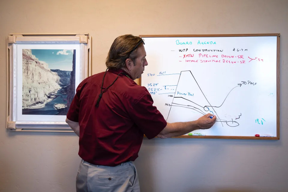
PAGE — At his office whiteboard on this dam town’s desert edge, the water utility manager recited the federal government’s latest measures of the colossal reservoir that lay 4 miles down the road, then scrawled an ominous sketch showing how far it has shrunk.
In his stylized drawing of Lake Powell, the surfacelapped just above where he marked his town’s drinking water pipe, bringing the Colorado River drought crisis uncomfortably close to home.
Against a diagram of Glen Canyon Dam’s concrete arch, Bryan Hill used blue marker to ink progressively shallower water lines from 22 years of Southwestern drought and overuse: 3,700 feet above sea level when full. Just 3,529 feet now.
He was updating a presentation he had created to reassure a worried City Council that it was merely time to act, not to panic. That day’s line fell just 39 feet above a black one Hill had drawn to indicate the dam’s hydropower intakes, the point at which the last of 1,320-megawatts flickers off.
As personal as the threat feels to Hill and his neighbors, his charts depicted a troubling reality for millions of other water users. If the lake keeps dropping below those generator intakes, dam managers will have difficulty pushing enough water downstream to keep Lake Mead from tanking and to satisfy the Southwest’s legal rights to water.
Lake Mead’s own decline threatens to upend a vast irrigated agricultural empire in Southern California and southwestern Arizona, and to restrict or eventually cut off a significant source of hydroelectricity and household water for the urban Southwest.
Powell once seemed Mead’s failsafe backup, a reservoir that, in a wet string of years, could accumulate far more than what the river delivers in a single year. During dry spells, it could pour its excess through Grand Canyon and into Mead, supplying users downstream.
Now the excess was gone. Hill’s drawing showed a reservoir on the brink after two decades of aridification, holding less water than it is supposed to send downstream in the coming year. Further declines could lend momentum to a long-simmering clamor for moving most or all of Powell’s stored water down to Mead.
If the snows that melt to replenish the reservoir are lower than expected this winter, the dam’s managers warn, it’s possible that water will dip below Glen Canyon Dam’s hydropower intakes by the end of 2023.
Page and a neighboring Navajo Nation community, Lechee, get their water from those same intakes, constructed at an elevation that government dam builders in the 1950s and ‘60s expected to remain forever inundated.
Bryan Hill, general manager of Page Power u0026 Water, draws the Glen Canyon Dam and Page’s water supply issues on a whiteboard on May 25, 2022, in his office. Page and neighboring Lechee get water from Lake Powell.
It was late May when Hill stood at his whiteboard, and snowmelt from the Rocky Mountains had started coursing down the Colorado to provide the storage pool a temporary, seasonal lift from its most recent record low. Still, the intakes sat just 39 feet below a surface that already had fallen 148 feet since the same date in 2000. After trees, plants and parched soil took their share, this spring’s runoff was shaping up poorly again. One more dry winter, Hill predicted, and “shit gets real.”
Page won’t go dry, for now. Its 7,500 residents and another 3,000 in Lechee will draw water from an emergency pipe link that federal officials are designing and connecting to tap deeper tunnels that allow managers to bypass the hydro powerplant when necessary or desired, such as for environmental flows downstream in Grand Canyon.
Even those tunnels are at risk of drying in coming years. Soon, the region’s accelerating aridification will force Page, like the vast irrigated farms and growing metropolises throughout the Southwest, to dig deeper for a solution.
A houseboat is anchored on Clear Creek at Lake Powell on Aug. 16, 2022. The future of Lake Powell, including its recreation opportunities, is uncertain after years of decreasing water levels.
Already, southern Nevada has spent $817 million to build a deeper tunnel under Lake Mead — a new “straw” into the reservoir — to keep water flowing to Las Vegas.
There are 40 million people who rely on the Colorado River water stored here, and millions more who eat the vegetables, beef and winter greens that it grows. They all face hazards on the desiccated horizon. For the few thousand who live on a red-rock bluff by the plunging reservoir, it’s in full view.
“It’s an American problem,” Hill said. “We just have a front-row seat.”
Those who love free-flowing rivers see this problem as an opportunity. Their canyon is returning, and with it the rapids and awe-inspiring rock features. Others fear the price spikes that will come with replacing the dam’s hydropower with other sources, or the loss of a motorized playground that provided thousands of jobs for decades.
As the Southwest braces for a worsening water crisis, one of its major holding tanks faces a growing identity crisis. Nature will have the final word in determining what Powell becomes, further draining it if drought worsens or refilling it if a wet period ensues. If recent trends hold, federal water managers face tough decisions in the next few years about how hard to fight to retain a shrunken lake at Page, and at what cost to other resources and users up and down the river.
Glen Canyon Dam and Page as seen on Feb. 3, 2022. Page was founded in the late ’50s as housing for those working on Glen Canyon Dam.
Drought weakens Lake Powell’s promise
Controversial from the start, 59-year-old Glen Canyon Dam arose as a compromise of sorts. Its construction sacrificed a secluded maze of desert river and side canyons after the U.S. rejected plans to flood other treasures, sparing places like Utah’s Dinosaur National Monument. After the dam buried Glen Canyon, environmental concerns ended a scheme for more dams in Arizona’s Grand Canyon, whose “grandeur,” “sublimity” and “great loneliness” President Theodore Roosevelt had famously cautioned could not be improved upon.
The government built Glen Canyon Dam in large part to ensure that exactly what is happening in 2022 would not happen. With Hoover Dam already impounding the nation’s largest reservoir in Lake Mead near Las Vegas, the river was ready to supply water to farms and cities in Arizona, Nevada, California and Mexico.
A second reservoir upstream at Lake Powell would almost double that capacity, theoretically ensuring that the headwaters states — Wyoming, Colorado, Utah and New Mexico— could store enough water there near the Utah-Arizona line to top Lake Mead off when needed.
Instead, Lake Mead’s decline has already triggered mandatory shortages for the Central Arizona Project and the Southern Nevada Water Authority, with deeper cuts in store for next year. Arizona will give up about a fifth of its normal share of the river in 2023, deepening the hardship for farmers in the middle of the state and reducing cities’ ability to store water in their aquifers for later use.
California’s senior water rights have so far protected it from reductions. Arizona decades ago accepted junior rights as a condition of congressional approval for the CAP canal that delivers water to Phoenix and Tucson.
When the states and federal dam operators split up shares of the river on paper in the 20th century, they gave 7.5 million acre-feet of water to the three states below Lees Ferry, a spot downstream of present-day Glen Canyon Dam, and an equal share to four states that share the upper Colorado and its largest tributary, the Green River. That would add up to 15 million acre-feet, with a few million more dedicated to evaporation and Mexico. Yet in this century, the river’s natural flow has averaged far less than was spoken for, just 12.4 million acre-feet.
An acre-foot — the amount it takes to cover an acre to a 12-inch depth — is the government’s water accounting unit and contains about 326,000 gallons. Each acre-foot can support two or three households, though a large majority of the Colorado’s water goes to farms.
Now, mighty Lake Powell, big enough to fit 25 million acre-feet on its own, is just a quarter full. Dam managers made emergency releases from smaller upstream dams earlier this year to prop up the reservoir, and also held back 480,000 acre-feet that otherwise would have flowed to Lake Mead.
On paper, the government decided to treat those 480,000 acre-feet as if they were already in Lake Mead, to keep that reservoir’s official holdings from triggering even greater austerity on downstream users. Winter weather will determine whether Powell can afford to let that water flow downstream next year and still produce power.
For next year, an official with Reclamation’s Upper Colorado Basin office said, the agency will work with states on a plan to release more from upstream reservoirs and to determine what administrative steps are necessary to continue releasing only 7 million acre-feet a year from Powell, if necessary, an amount made possible by the cutbacks in Arizona, Nevada and Mexico.
In announcing next year’s shortage, Reclamation officials said the conservation efforts throughout the Colorado River basin must increase by 600,000 to 4.2 million acre-feet a year, depending on weather, to stabilize the reservoirs at current levels over the next four years. That worst-case figure, 4.2 million, represents more than a third of what the river’s flow has averaged during the long drought. It’s almost as much as California, the biggest user, takes from the river.
It’s unclear where such a large savings could be found, though the region’s Democratic senators won $4 billion in climate legislation passed this summer. It could help pay for efficiency upgrades and to compensate farmers who agree not to use their full share of the river.
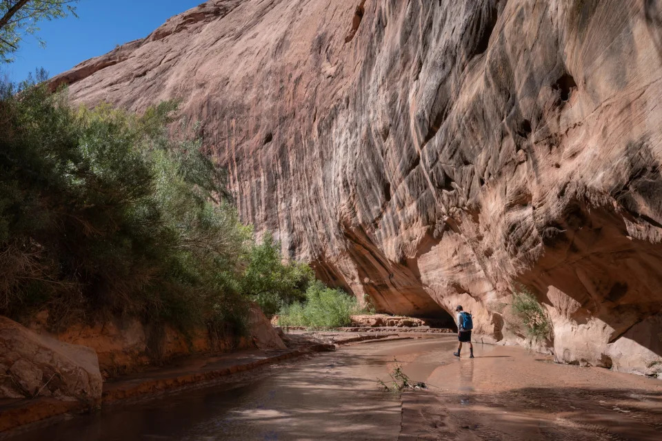
Eric Balken of the Glen Canyon Institute hikes up Lake Canyon on Aug. 16, 2022. This area in Lake Canyon was under water for approximately 20 years and now has been dry for approximately 20 years, due to declining lake levels. The area has seen a resurgence of vegetation, like Goodding’s Willow.
‘I’m not the one draining this’
As the receding waters expose canyons, rock features and even whitewater rapids that long were buried under the reservoir, some who love the river for itself see nature reclaiming its rightful place.
“You can hear it,” Utahn Eric Balken said as he tromped through dense cattails and creekside willows during his first inspection of the reemerging Slick Rock Canyon, one of many remote watershedsnotched into Glen Canyon’s sandstone. “There’s lots of bugs buzzing around. I was stepping over frogs left and right.”
Discoveries like these thrill Balken, who directs the nonprofit Glen Canyon Institute. His organization has long advocated draining Lake Powell and storing its water downstream in the similarly depleted Lake Mead. Now, he figured, nature was doing his work for him. He and allies believe Lake Mead was always enough to serve the region’s needs, and that it makes little sense to divide the water now that it’s so low.
Indian paintbrush grows in Lake Canyon on Lake Powell. As water recedes, plants and animals are returning to canyons that were once under water.
Motoring out of Bullfrog Marina in mid-August, he said he tries to keep a low profile when boating from canyon to canyon, given how attached house boaters and water skiers are to their impounded playground. Soon, though, it may not matter what anyone wants for Lake Powell.
“Guess what?” Balken said. “I’m not the one draining this.”
Slick Rock, south of Halls Crossing, now supported multiple beaver dams and ponds, but also held disappointments for Balken. Tumbleweeds choked the zone nearest the retreating reservoir, while a nonnative grass vine crisscrossed the creek bed and threatened to outcompete the native flowers and grasses seeking a foothold. There are remnants of a dam-altered floodplain that he hopes will fade as nature takes over.
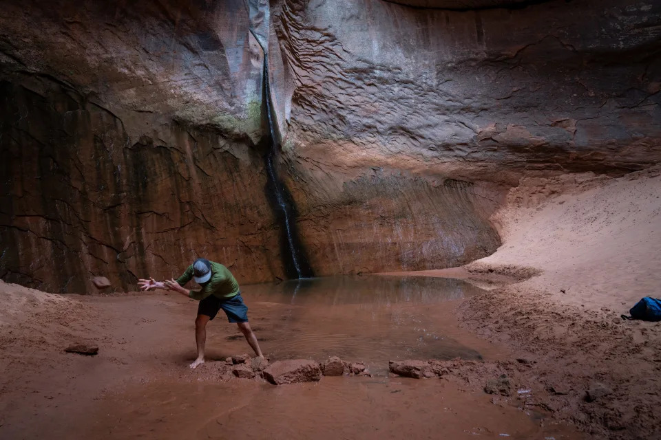
A notch to the north, Lake Canyon, yielded unequivocal joy for Balken the next morning. He throttled his boat up the meandering sandstone canyon and past a slalom of ghostly gray cottonwoods that still jut from the flatwater that buried them in the 20th century. He drove a sand spike into the beach to secure the boat, marched through a wall of briars and over a logjam deposited by recent flash flood, then emerged into an open canyon with a flowing stream.
Soon, a rushing waterfall echoed from the canyon walls and pitched muddy water from its bedrock perch like a monsoon deluge draining from a flat-roofed adobe.
Walking up on resurrected features like this, or on rock grottos or natural bridges elsewhere around Lake Powell, feels a bit like discovering Atlantis, long rumored to exist under the sea but buried under the waves for ages. The upper reaches of Lake Canyon’s dam-flooded zone first saw daylight again some 20 years ago, but this particular waterfall remained inundated until more recently.
Gregory Natural Bridge at Lake Powell pictured on Aug. 15, 2022. Until recently, this natural bridge was entirely under water.
Even after the water retreated, Balken and colleagues three years ago walked across lakebed sediments that still entombed it. Flash floods apparently blew out those deposits to expose the falls, which in turn blew his mind when he first saw it and heard its power.
“I love to see a creek finding its original bed,” he said.
More consequential treats awaited as he ascended the canyon this time. Atop the falls, 15-foot willows sprang out of a cutbank and rang with birdsong, evidence that the native vegetation and rust-colored canyon wrens can quickly return here.
Around elevation 3,650 feet, a mark that first reemerged some 20 years ago, some willows reached to 40 feet. Then came the cottonwoods, towering kings of the desert oasis, first one seedling at a time, then in tall clusters at higher elevations, and finally in dense ribbons of forest. Underfoot, purple wildflowers sprouted. Cicadas droned.
In the 1950s and ‘60s, when Reclamation Commissioner Floyd Dominy pushed for and finished the dam, Balken said, the dam builder had argued there was nothing of value to preserve there. Indeed, into his old age early in this century, Dominy asserted that he had improved the environment.
“I believe that nature can be improved upon,” he told High Country News in 2000, when Powell was nearly full and only academics used the term “megadrought.”
“This is a miracle,” Balken said in Lake Canyon’s recovery zone. “Our values have clearly evolved. Clearly, there is something here.”
But one canyon’s gain may be another’s loss.
Eric Balken of the Glen Canyon Institute walks up a sediment deposit hill at Cathedral in the Desert on Aug. 15, 2022, at Lake Powell.
Jack Schmidt traveled to a park in Moab, Utah, on a June evening to explain the Colorado’s woes to a few dozen interested Utahns and Canyon Country visitors. Schmidt is a Utah State University watershed scientist who has spent his career studying the river, and he leads a band of regional researchers who publish science and policy white papers through the Center for Colorado River Studies. To his eyes, Glen Canyon’s reemergence is both locally beautiful and regionally troubling.
“Don’t kid yourself into thinking the only environmental issue is everything wonderful in Glen Canyon popping up again,” Schmidt said to the crowd assembled on folding lawn chairs for a weekly Science Moab discussion and movie viewing. (The post-apocalyptic sci-fi “Waterworld” was the flick that week.)
During the Obama administration he served as head of the Grand Canyon Research and Monitoring Center for 3 ½ years, and before that he proposed what would become a series of artificial floods from Glen Canyon Dam to push sand downstream and offset some of the dam’s profound damage to the Grand Canyon’s ecology.
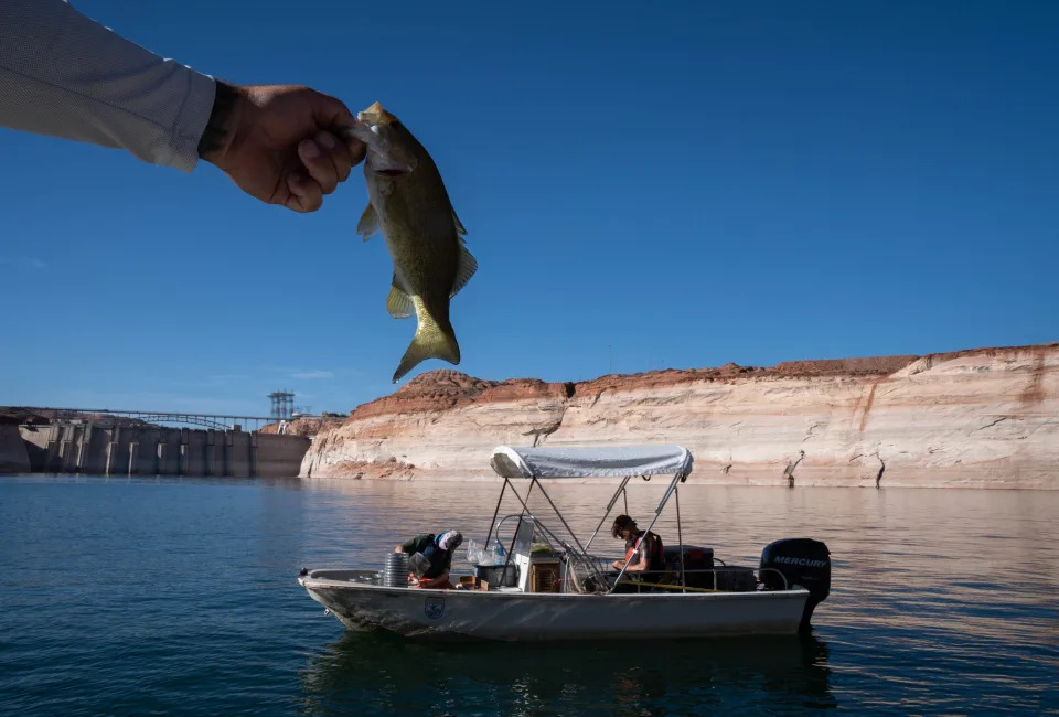
But Schmidt had another threat to Grand Canyon on his mind. Smallmouth bass were massing just upstream of Glen Canyon Dam, where the declining water levels brought the lake’s relatively warm surface close to the hydropower intakes. If enough bass or other nonnative, warm-water sportfish slipped through the turbines to start a downstream population, they could menace a recovering population of native humpback chubs.
Paul McNabb holds a small mouth bass, while Utah State University researchers record fish species during a survey on June 9, 2022, above Glen Canyon Dam on Lake Powell.
If that happens, he said, it’s “game over” for a fish that has swum Grand Canyon for millennia.
On that summer evening in the park, Schmidt urged his listeners to demand action if they care about saving the river environment. The United States must address two seemingly intractable problems, he noted: climate change and overuse.
Bullfrog Marina at Lake Powell pictured on June 15, 2022.
The challenges of climate and overuse
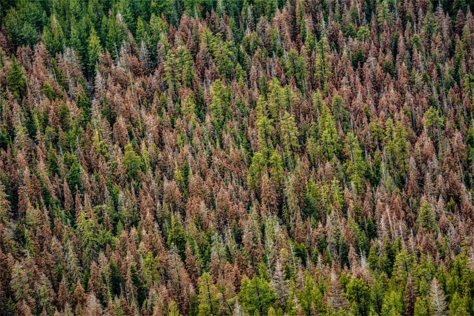
Scientists have explained the long-term crisis that a warming Rocky Mountain region is imposing on the Southwest as a “hot drought.” As the region warms, even snowpacks that seem healthy while piled up in the mountains can result in a trickle into reservoirs after the atmosphere, stressed trees and dry soils soak up their share.
A 2017 study by scientists at the University of Arizona and Colorado State University found that warming exacerbated the current drought to reduce annual flows by about a fifth, and that unabated greenhouse gas emissions through this century could push losses to a third or more of the river’s normal flow.
Lake Powell near Bullfrog Marina pictured on Aug. 15, 2022. Previous water levels are visible on the walls surrounding the lake.
The Bureau of Reclamation itself warned a decade ago that climate change would eat into the river. Its projections of a 9% reduction in flows by mid-century underestimated what has already happened to the river.
“The important point,” Schmidt told his audience that day in Moab, more than 300 miles from his home campus, “is I shouldn’t have driven down here from Logan in a gas-guzzling van and loaded the atmosphere with carbon, I guess.”
The second problem, overuse, is more immediate. In recent years, the dam-stored equivalent of the entire, shrunken river’s flow has gone to supply California, Arizona, Nevada and Mexico, including evaporation in Lake Mead. Although the less-populous upstream states of Wyoming, Utah, Colorado and New Mexico take much less, the combined effect is depletion of reservoirs that once held several years’ worth of flows.
Schmidt’s solution, he would later tell The Arizona Republic, is to reengineer Glen Canyon Dam to allow it to spill water into the river and through Grand Canyon even after it sinks lower than the existing hydropower intakes and bypass tunnels. That might require drilling new and lower tunnels through the sandstone beside the dam. At least, he said, the government must study that option, because without it the drought could push the reservoir into “dead pool,” when a river no longer flows from it until more snowmelt arrives to buoy the surface.
“We should know what it costs to bypass,” Schmidt said.
On that, Schmidt and Glen Canyon preservationists like Balken agree. The Glen Canyon Institute this summer joined the Utah Rivers Council and Great Basin Water Network in calling on the Bureau of Reclamation to study such a plan that would, effectively, allow managers to drain Powell while leaving the dam in place.
The Colorado River (right), pictured on June 11, 2022, near Hite, Utah. The sediment delta and Lake Powell’s low water levels have cut off Farley Canyon (bottom left) and White Creek Canyon (top left) from the river and what used to be Lake Powell.
But Schmidt would not drain the lake. Instead, he said, lower bypass tunnels would allow the government to decide how much storage Lake Powell needs in order to consistently send water downstream based on Grand Canyon’s environmental needs. It would still hold back water, but in dry times Lake Mead would need to handle the bulk of the Southwest’s storage needs. Reengineering the dam could cost tens or hundreds of millions of dollars, depending on the design. The Bureau of Reclamation has directed $2 million toward a study of options.
“There’s no way in this country we’ll eliminate the potential storage at Powell,” Schmidt said. The question is how often it will be actual storage, and how often mostly potential.
A boat cruises on Lake Powell near Bullfrog Marina on Aug. 15, 2022. Boat ramps have had to be extended multiple times as water levels receded at Lake Powell.
Tough choices for recreation
The National Park Service has spent several million dollars extending concrete boat ramps at Stateline in the south of Lake Powell and Bullfrog in the north, to enable continued access for houseboats. But that work likely won’t be enough to support the park’s congressional mandate to manage for boat recreation, and so the agency is planning a bigger investment.
The Bullfrog Marina ramp can handle houseboats only until the reservoir’s surface sinks below elevation 3,529 feet, park officials said in August. By then the spring snowmelt runoff had helped the lake rebound past that point, precisely where it had hovered when Hill had drawn it on his whiteboard in March.
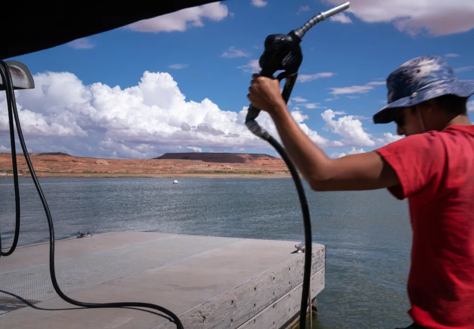
A Bullfrog Marina employee fuels a watercraft at Lake Powell on Aug. 16, 2022. The marina was scheduled to be moved into the Colorado River main channel because of declining water levels.
The Bureau of Reclamation’s current projections show Lake Powell likely dropping back below that mark in September but rising to it again by next June. Seeking a longer-term solution, the Park Service is applying $26 million in federal disaster funding it received this year toward building a new ramp at Stanton Creek, a nearby but deeper part of the lake that could reach elevation 3,450 feet. That would enable boating well after the reservoir drops below the point of generating electricity.
The uncertainty is forcing boaters to make hard choices. Tom Parker, a semi-retired contractor from Erda, Utah, wasn’t sure whether to haul his houseboat out from its mooring at Bullfrog as the season winds down. He wanted to get it on dry land to scrape off the quagga mussels that crust over the hull, the engine and water intakes. But with the reservoir continuing to fall, he wasn’t sure he could risk it.
“If you get it out, you might not get it back in. That’s the problem,” he said while lining up on the ramp on a mid-August morning.
Parker was launching personal watercraft for his children and grandchildren to zoom around on during a stay on the houseboat. That’s something he’s done routinely over the years, as someone from his extended family visits the boat at least every other week in summer. Some even work remotely from it now that there’s a satellite internet link.
Eric Balken of the Glen Canyon Institute dismantles a rock dam at the base of the waterfalls at Cathedral in the Desert on Aug. 15, 2022, at Lake Powell.
‘You can’t improve on nature’
Balken, the activist who longs for the reservoir’s demise and the river’s return, acknowledges that lots of people love lake recreation. Before them, though, there were those who loved the river and loathed what became of it after the dam. They include people he has known, like the late singer and renowned river guide Katie Lee, who didn’t live to see Glen Canyon’s return, and Ken Sleight, also a pre-dam guide and one who still yearns for the death of “Lake Foul.” Balken said he’s motivated partly by “the pain of their loss.”
Eric Balken of the Glen Canyon Institute rests at Cathedral in the Desert on Aug. 15, 2022, at Lake Powell. This area, known for its beauty, was buried when Lake Powell filled.
One of their losses was Cathedral in the Desert, a shady sandstone grotto in a side canyon that admits a beam of sunshine to backlight a ribbon of water falling through a narrow slot. It was a place Sleight discovered while guiding tourists out of Escalante, Utah, on horseback before Lake Powell flooded it. Today, it’s back from the depths.
When Balken approached its sandy base in bare feet this summer, he found a row of rocks that someone had placed as a dam across the stream at its base, perhaps to raise a pool for bathing beneath the falls. He promptly chucked the rocks aside.
“You can’t improve on nature,” he said.
At home outside of Moab, Sleight looked at freshly shot digital photos of his beloved Cathedral in the Desert, and at new images of other side canyons. Their rebirth pleased him, but had taken too long.
“I don’t think I’ll be doing any more river running,” he said. “I wish I could.”
Ken Sleight pictured on Aug. 17, 2022, in Moab, Utah. The guide inspired a character in author and friend Edward Abbey’s book u0022The Monkey Wrench Gang.u0022
Sleight spoke softly and haltingly while sunken into his sofa, worn down from days of waging his own struggle with the fickle climate. A wildfire last year denuded the hills above his home, and recent monsoon rains had rushed over the bare ground and washed out small bridges on his property. He and wife, Jane, had been busy with repairs.
In younger days, the guide had befriended author Edward Abbey partly out of a shared disdain for the dam, and he had inspired a character, Seldom Seen Smith, in Abbey’s signature novel, “The Monkey Wrench Gang.” He still invokes his late friend’s prayer “for a precision earthquake to take down the dam,” but says he doubts it will now take an act of God to drain the reservoir.
“I’m 93 now and I don’t have too much time to live,” he said, “but I’m sure hoping I can live long enough to see it go.”
If the Colorado does flow freely through Glen Canyon again, he fears, there will be a new threat: people. Even before the dam, he remembered, the place had become crowded for his taste. A renewed Glen Canyon will require careful management, he believes. “It’s going to attract thousands, because it’s so beautiful.”
North Wash boat ramp, June 10, 2022, on the Colorado River, near Hite, Utah.
Amid new beauty, dangers lurk
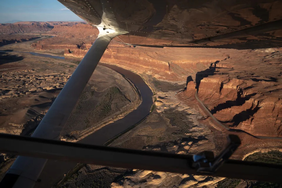
From an airplane over Lake Powell’s upper reaches, the folds and crevasses of mud resemble a dirty glacier plowing through the Colorado Plateau.
As the reservoir retreats from the floodplain’s edge, where for decades the river dropped sediment it had eroded from points upstream, the accumulation slumps raggedly away from sandstone walls as a fault line would in an earthquake.
This is no flightseeing tour of geologic time, exhibiting Earth’s grindingly slow mechanics as they carve Canyon Country’s latest wonder. It is instead a real-time window on the fast-moving consequences of a changing, drying regional climate and the Southwest’s slow response to it as Lake Powell drains toward oblivion.
A Western River Expeditions raft is taken off the Colorado River at North Wash boat ramp near Hite, Utah, on June 10, 2022.
River rafters paddling or motoring down from Moab years ago were forced to abandon the Hite takeout ramp on the narrow upper lake’s east side, in favor of an intimidating gravel incline called North Wash on the west side. The makeshift ramp has steepened as the bank at its bottom continues to slough, making for a difficult retrieval of the big, motor-equipped rafts that tour company guides pilot down from Moab daily in summer.
After customers step out and walk toward a waiting bus, a pickup with a trailer backs gingerly down the top of the embankment and sets its brake. Guides from multiple boats then push and pull the rafts uphill on inflatable rollers. The combination of massive loads on the hill and deep muddy waters at the bottom requires vigilance.
“It’s scary,” Hannah Wood, a seasonal Moab-based guide from northern Utah’s Salt Lake valley, said when she arrived at North Wash after a June trip. “Every time we come here I’m worried someone will die.”
Wood said a colleague had fallen at the ever-changing takeout’s edge, and had cut himself on the raft’s motor. While the rapids upstream in Cataract Canyon are supposed to be the trip’s big thrill, she said, takeout at this site is “the most dangerous part of our job.”
A boat cruises on Lake Powell near Bullfrog Marina on Aug. 15, 2022. Lake Powell was at 25% of capacity and more than 160 feet below full pool.
The only other place to take out is at Bullfrog Marina, a two-day motor across flatwater. But even that has become problematic for operators of larger rafts, as the shifting and shallow mud beneath the delta that’s emerging downstream of North Wash can trap the heavy rigs.
The river also appears to be building a waterfall over a sediment deposit upstream of the North Wash takeout, threatening further complications.
The same thing happened hundreds of miles downstream when Lake Mead drained away from the lower Grand Canyon. There, a waterfall made Pearce Ferry the final takeout chance for Grand Canyon river trips.
Already, North Wash is “probably the worst boat ramp in North America,” Moab river runner and pilot Chris Benson said while looking down from a rented four-seat Cessna Skyhawk that’s usually used to give rafting patrons a look at Canyonlands National Park on the way back to their cars in Moab.
The North Wash boat ramp (center, right of river) on the Colorado River, near Hite, Utah, pictured on June 10, 2022. The way Lake Powell has receded has limited takeout points for river rafters.
Benson’s friend, river guide Pete Lefebvre, pointed to a muddy riffle upstream of the ramp, near where the Dirty Devil River meets the Colorado, fresh evidence of a fast-changing landscape. “That wasn’t there two days ago,” he said.
Benson and Lefebvre are amateur “investigators” with a small nonprofit group of river enthusiasts called Returning Rapids. They photograph and share changes in the river and lake environment as the water recedes. Their work can help other recreationists navigate new hazards, but increasingly they also want government officials to take notice. As the reservoir’s northern edge creeps downstream, they say, the river is pushing its mud delta farther south.
Mike DeHoff (right), with the Returning Rapids Project, points out the sediment delta on a map of the Colorado River at Swanny City Park in Moab, Utah, on June 10, 2022,
This mud is what the group considers the “tailings” from the region’s “mining” of the Colorado River: The West used up the water and left a mess more than a hundred feet deep. They call these deposits the “Dominy Formation,” in honor of the late dam builder.
Farther downlake, the San Juan River, a major tributary that joins the reservoir, has pushed its delta closer to Lake Powell’s main channel. When that happens, possibly in a few years, they fear the band of mud could at least temporarily cut Lake Powell in two, creating a new set of hazards.
Who will mind the mud? How will it affect recreation, the environment and safety? To date, there’s no plan.
“Are we making a conscious decision?” Lefebvre said. “Or are we just saying, ‘Oh, that’s Lake Powell. That’s just what happens.’”
A Western River Expeditions raft is taken out of the Colorado River at North Wash boat ramp, near Hite, Utah, on June 10, 2022.
Worried as they are about the mud, Returning Rapids members are unabashedly joyful about what else the reservoir’s decline is giving them. It’s in their name: the whitewater rapids that are rising again from lower Cataract Canyon, the river stretch that is no longer inundated.
Eleven rapids have returned, clearly visible from the air and adding about 50% more fun to the 22 that the float trip previously offered. Lefebvre points them out from above, each the result of a side canyon whose drainage has poured boulders into the Colorado over the ages. Several of them have emerged alongside sandy camping beaches of the sort that river runners covet.
“Good for us!” Lefebvre said.
At North Wash, where Wood was helping offload rafting clients and trailer the rafts in June, one client said he had a blast on his multiday river trip, but worried about what Lake Powell’s plunging waterline portends.
“In 20 years the Colorado River won’t be here,” said Jeff Dudek, a tourist from Prairieville, Louisiana, “unless something drastic happens.”
Will hydropower survive the crisis?
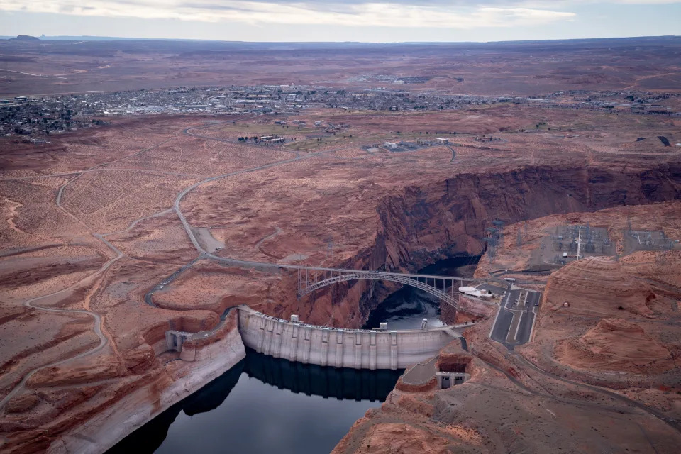
Glen Canyon Dam pictured on Feb. 1, 2022. There are 40 million people who rely on the Colorado River water stored here
More than 4 million Americans who buy Glen Canyon Dam’s power also stand to lose as the water recedes. Consumer-owned utilities from Arizona to Wyoming, including Native American entities like the Navajo Tribal Utility Authority, will need to add new and likely costlier sources to their mix.
Supplemental sources could include solar, pumped-storage hydro projects or even small, modular nuclear plants, said Leslie James, who directs the Colorado River Energy Distributors Association. If Glen Canyon loses all of its power-generating capacity, it would shut off the primary revenue source that pays for the dam’s operations and maintenance. The dam accounts for $119 million of the $150 million that electric generation pumps into a basin fund that also aids environmental initiatives on the river.
Looking at the government’s current projections for flows and reservoir levels, she fears Glen Canyon water will dip below the minimum level for power production by 2024.
Before then, James hopes, a bill proposed by Sen. Mark Kelly, D-Ariz., could help limit the pain. Kelly’s bill would keep the government from collecting standard operations and maintenance or dam financing fees from hydropower customers when the dam isn’t actually churning out electricity because of drought.
Improved forecasting technology could help the Bureau of Reclamation fine-tune releases from upstream reservoirs such as Navajo or Flaming Gorge to maximize their effect. Ultimately, though, the river’s hydropower users are at nature’s mercy.
“It needs to rain and snow,” James said.
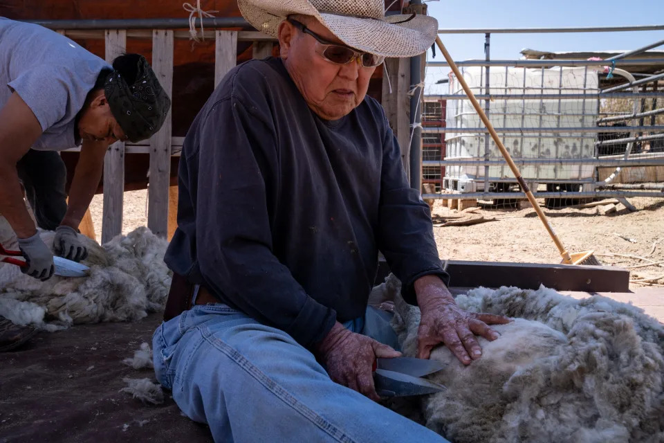
Michael and Marjorie Bigman shear sheep in their camp near Coppermine on the Navajo Nation on May 24, 2022. The Bigman’s haul water from Pageevery other day, for their sheep, goats, cattle and horses.
Learning to live with less
At the Navajo community of Lechee, outside of Page, coping with drought is a way of life. The houses, many of them mobile homes, have brown yards. Rural residents beyond the village have cut back on sheep and cow herds, partly to offset the cost of hauling water and partly because there’s little grass for the livestock to eat.
And yet, like Page, Lechee exists as a population center because of Lake Powell and access to its water.
Jimmy Shaw of White Mesa fills the 55-gallon barrels in the back of his truck at the Marathon water station in Page on May 26, 2022. Shaw hauls water for his sheep, goats and cattle.
“My parents remember when it was just a little bitty stream, before the dam came,” said JoAnne Yazzie-Pioche, who heads local government as the Lechee chapter president. Navajos made do with groundwater pumped by windmills, and did not build their homes next to each other.
Then Page tapped the dam, and Lechee got access to water piped from the same intake. With that, some congregated around the village water tower, while others remained in rural homes but trucked water from a filing station in town. They brought water to maintain livestock, but are now culling herds because of both the expense of hauling and the drought-stricken forage.
Watching Lake Powell’s decline has been painful for Yazzie-Pioche, for multiple reasons.
For one, her dad was a laborer who helped build Glen Canyon Dam during her childhood. She frequently boated and camped on the lake for recreation while raising her own children, back when the monolith Lone Rock on the lake’s south end was surrounded by water.
“We love Lake Powell,” she said, though her children have grown and moved to metro Phoenix, and the lower water has reduced the draw for her personally. “It’s sad to see. And not a whole lot of beaches. But still, people do come.”
Her community, like neighboring Page, is hoping for a new water source that draws from deeper than the dam’s hydropower intakes. The Navajo Nation has begun work on a pipeline from the pump upstream of the dam that supplied cooling water to the now demolished coal-fired Navajo Generating Station.
Even before it comes online, the plunging water line is raising questions about this new source’s viability.
“We’re just like, ‘Great. We finally have access to Lake Powell on this side, on the (Navajo) Nation’s side, but the water’s going down,” Yazzie-Pioche said.
The Southwest must learn to live with less, she said, from the lawns of Phoenix to the farms of Yuma. Whatever happens along the Colorado, though, there will still be windmills around Lechee.
“We’re always going to be here,” she said. “We were here prior. Even when we had no water, people still lived here.”
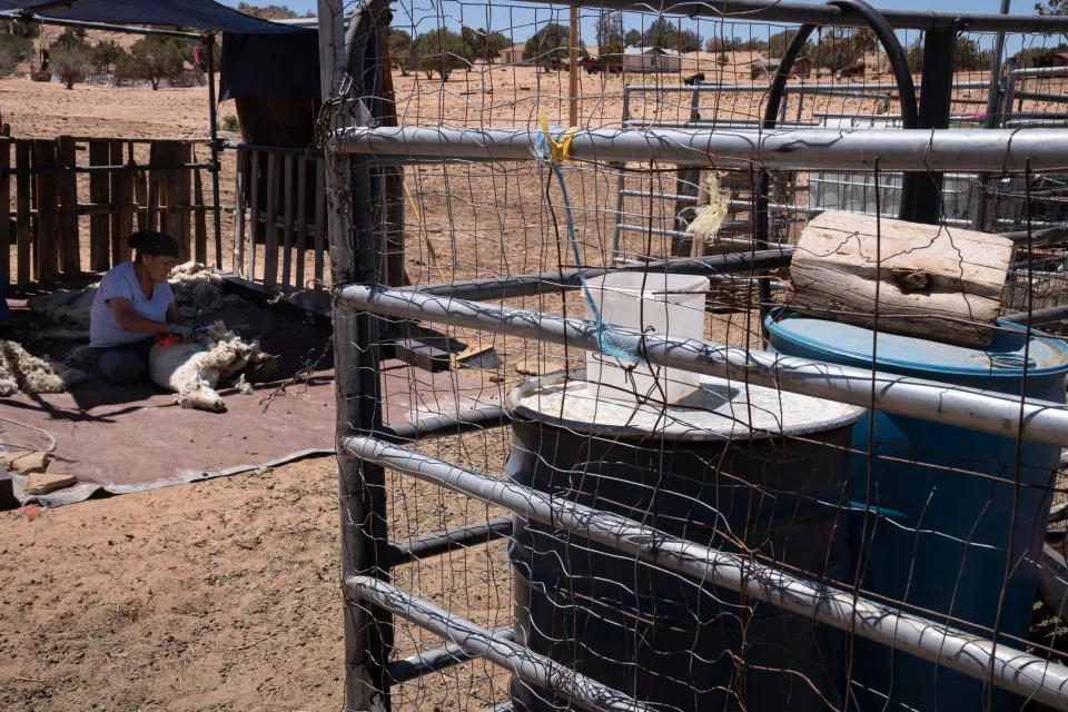
Marjorie Bigman shears a sheep on May 24, 2022, near Coppermine on the Navajo Nation.
Page was not there before the big water. It was founded in the 1950s to house the workers who built Glen Canyon Dam. They came to improve on nature.
“The federal government built Page,” said Hill, the city’s utility director. ‘Yea verily,’ in 1957 they said, ‘There shall be Page.’”
It was a proclamation with echoes across the Colorado River’s 1,450-mile length, not least along the federally backed projects importing water to Phoenix and Los Angeles.
What the government created, Hill said, the government should fix. Page needs a new and deeper intake beyond the quick fix that the Bureau of Reclamation is planning within the dam. A new intake outside of the dam would protect the city’s supply of drinking water even if drought pushes the lake to “dead pool,” lower than the dam’s bypass tunnels. But it will cost $40 million, he said. The city is angling for federal funds to build it.
Whatever identity Lake Powell ultimately assumes, the costs will ripple far beyond its waters.
Brandon Loomis covers environmental and climate issues for The Arizona Republic and azcentral.com.
Environmental coverage on azcentral.com and in The Arizona Republic is supported by a grant from the Nina Mason Pulliam Charitable Trust. Follow The Republic environmental reporting team at environment.azcentral.com.
Chinese Rocket Stage Now a Cloud of Orbital Debris After Disintegrating in Space
Passant Rabie – December 13, 2022
China’s Long March-5B Y3 rocket carried the Wentian lab module to China’s space station in July.
On November 12, China’s Long March 6A rocket broke apart after launch, scattering debris in low Earth orbit. Now, reports suggest that the disintegrated upper stage of the rocket has grown to a cloud of 350 pieces of space debris.
The rocket launched at 5:52 p.m. ET on November 11 from Taiyuan Satellite Launch Center in north China, carrying the Yunhai 3 environmental monitoring satellite.
Shortly after delivering the satellite to low Earth orbit, the upper stage of the Long March 6A rocket broke apart, the South China Morning Post reported at the time. The U.S. Space Force’s 18th Space Defense Squadron tracked 50 pieces of space debris resulting from the rocket’s break up at an estimated altitude of 310 miles to 435 miles (500 to 700 kilometers), the squadron announced on November 13.
Nearly a month later, experts are still tracking the disintegrated pieces from the rocket. “There are now 350 debris objects cataloged from the Nov 12 disintegration of a Chinese rocket stage (CZ-6A Y2), in sun-sync orbit,” Jonathan McDowell, an astronomer at the Harvard-Smithsonian Center for Astrophysics, wrote on Twitter based on ongoing tracking by the Space Defense Squadron.
China has been reckless with its rockets before, but the Long March 6A rocket breakup wasn’t meant to happen. The rocket’s upper stage was supposed to reenter Earth’s atmosphere in one piece, and burn up during reentry. It’s not clear what went wrong to cause the rocket to break up before its reentry.
The rocket breakup sent debris flying near Starlink’s internet satellites, but Chinese officials are claiming that pieces of the rocket will not threaten other low Earth orbit assets. “As far as we know, the relevant incident will not affect the Chinese space station or the International Space Station,” Mao Ning, spokesperson for China’s Foreign Ministry, is quoted in the South China Morning Post as saying during a press conference.
As of last year, more than 27,000 pieces of space debris were being tracked in orbit by the Department of Defense’s global Space Surveillance Network, with lots of smaller pieces also floating around undetected.
Tempted to joke about global warming amid a blizzard? Here’s what experts say about that.
Elizabeth Weise, USA TODAY – December 13, 2022
Winter storms are pummeling the United States, snow is piling up, temperatures are dropping, traffic is snarling and there’s always the threat of thunderstorms and thundersnow.
Just like clockwork, the emails, tweets and Facebook posts start flowing. Maybe it’s a joke, maybe it’s a snarky critique, maybe it’s a meme. The words change, but the format is familiar: If global warming is real, why is it so cold out?
Scientists likely don’t think that joke is as funny as another familiar climate change quip: Never argue about climate change – it always turns into a heated debate.
But we asked experts to weigh in on the winter weather trope. Here’s a few thoughts on what winter means in an era of global warming.
Cold winters don’t mean there’s no global warming
Atmospheric science professor Dan Chavas at Purdue University in Indiana says these arguments don’t frustrate him because they’re a chance to engage.
“I think most of the time when people say that, they are joking and do not seriously believe that the occurrence of winter disproves climate change,” he said. “For me personally as a scientist, I see that type of comment as a potential opportunity to talk about climate, the seasons, and climate change if they seem interested.”
He starts that conversation by agreeing that climate has always had seasons, but notes climate change is a gradual warming – on top of the seasons – that’s making winters, springs, summers and falls all warmer over time.
Higher temperatures don’t mean it’s hotter everywhere all the time
Global temperatures have risen 1.9 degrees Fahrenheit since 1880. That doesn’t mean it’s hotter everywhere all at once but that the entire system is becoming more volatile.
“As you add energy to the system, both extremes grow. You can have Texas ice storms as well as 33 million people displaced in Pakistan due to heat and flooding,” said Julio Friedmann, chief scientist at Carbon Direct, a carbon-management firm and a former professor at Columbia University. “These sorts of changes were predicted in 1996, it’s not news that this is happening.”
That said, winters are indeed getting warmer.
Since 1896, average winter temperatures across the lower 48 states have increased by nearly 3 degrees, according to the Environmental Protection Agency. Nationally, 57% of US Weather Service stations have shown a decline in snowfall since the 1930s.
Winter weather is now on average 14-and-a-half days shorter and summers are seven and a half days longer, according to Brian Brettschneider, a climate scientist with the University of Alaska at Fairbanks
“Global warming will not stop the seasons, but it is causing long-term trends in winter conditions that are robust and accelerating,” said Jason Smerdon, a climate physicist at Columbia University.
The odds are shifting to hotter extremes
But climate change is never all one thing or another. Rather it is a shift in the odds of occurrences of extremes, said Gerald Meehl, a senior scientist with the National Center for Atmospheric Research.
Over the U.S. during the past decade, it is twice as likely that a daily record high maximum temperature occurred at a given location compared to a daily record low minimum, he said.
“For every two daily record high maximums that are set, there is only one daily record low minimum. This is climate change happening before our eyes,” he said. “If the climate wasn’t warming, there would be an equal chance of a daily record high temperature being set compared to a daily record low minimum.”
Over the rest of this century, the number of extreme heat events will rise, even though there are a few extreme cold events.
“I’ve said that the scientist sitting at my desk in the year 2100 will get a phone call on a cold day in January 2100 when a daily record low minimum temperature is set in Denver,” he said.
That caller will want to know what happened to global warming because a record cold temperature has just been recorded.
“That scientist in my seat will answer that yes, it was cold on that one day,” he said. “But think back to the previous summer when nearly every day set a daily record high maximum temperature.
Amy Baefsky, who had to sell 10 percent of her and her husband’s hundreds of cow-calf pairs after a lack of rain and brutal winds left little grass for feeding; on her way to feed cattle at Fort Union ranch in Watrous, N.M., Nov. 29, 2022. (Ramsay de Give/The New York Times)
Rock Ulibarri had a vision for his ancestral homestead nestled in a canyon in the mountains of northeast New Mexico: Open it up to tourists, who would pay for pit-smoked pork, mountain bike tours of the craggy terrain and works by local artisans.
He wanted to build the sort of business that could raise local income levels and help rural residents stay on their land, rather than sell to outsiders. That aligned with the state’s plans, too: The governor had created a division in her economic development department to promote outdoor recreation.
So Ulibarri started building campsites and a small guesthouse, even retrofitting the one-room cabin where his father was born. Early this year, he was ready to book a summer of visits.
Then, on an April day with blistering winds following months of only trace rainfall, the mountain went up in flames.
Ulibarri and his partner, Becky Schaller, held out as long as they could, even as the electricity failed and smoke clouded the sky. When the winds turned in their direction and they saw the blaze creeping over the mountain, they loaded up their goats, dogs, horses and parrots into a big trailer and drove slowly down to safety.
Surveying the damage later, they saw their buildings had been spared, but the trees on the ridges were gone — along with the fences they needed to confine their animals, and the trails in the surrounding forest they were counting on for bikers and hikers. Also, the river was running inky black with ash. A year’s worth of food in their freezer had perished. And the business plan was on ice.
By the end of the season, they were able to host one group, and they plan to try again next year. But Ulibarri wonders whether the business model he’d hoped his neighbors could emulate is viable. Even before the fires, he noticed less snow on the mountains and fewer fish in dwindling streams. For years, fire managers had suppressed natural blazes, so there’s still plenty of timber left to burn again.
“Climate change does scare me, a lot, because we really don’t know what it’s going to look like, you know?” he said. “Just what I’ve seen so far in my lifetime, the changes are incredible.”
The changes are indeed incredible. So are the costs.
The study of how climate change affects economies is still relatively nascent, but evolving fast. Economists are grappling with bigger shocks than even scientists had anticipated, in the form of catastrophic events like hurricanes and wildfires, as well as the slow, creeping influence of drought, extreme heat and rising sea levels.
Unlike its neighbors to the east and west, New Mexico is tackling the economic challenge head-on, passing legislation and funding programs to mitigate the effects of climate change. Complicating that effort: The state’s primary taxpayer, the oil and gas industry, is also the main source of the disruption.
For that reason, New Mexico faces what economists call “physical risk” and “transition risk”: the financial damages of extreme weather and shifting temperatures, and the damage caused by doing something about it. To offset those risks, the state is working to diversify into other industries. The problem is, some of those that offer the most potential are vulnerable to climate change themselves.
“In looking for alternatives to extraction as ways to fuel New Mexico’s economy, the two that always jump out most immediately are tourism or outdoor recreation and agriculture,” said Kelly O’Donnell, an economic consultant. “And obviously those are two of the industries that very likely will suffer extreme damage from fires, floods and drought.”
Getting ‘Hit Over and Over’
The days before the fire carried a sense of foreboding — different, Phoebe Suina remembers, from years past. She had dealt with the aftermath of many blazes before, as an environmental engineer who helps communities respond to natural disaster. This time, it had barely rained in the northern part of the state in months, the snowpack was already gone, humidity was minimal and the winds were so intense that it was hard to walk outside.
“This April, I remember having that sinking feeling — how I can explain it in English is, all the elements of a major imbalance were occurring,” Suina said. “And it wasn’t going to be a one-time thing. We have to figure out how we’re going to survive.”
The Hermit’s Peak and Calf Canyon fires started in April, after the U.S. Forest Service conducted what was supposed to have been a controlled burn to thin the dense undergrowth. High winds whipped both fires into a megacomplex that ultimately torched 342,000 acres across three counties, and wasn’t fully controlled until mid-August.
Then came the flooding. With no trees to hold back the mountains, monsoon season sent rivers of sediment coursing through the gullies, spilling over roads and onto the homes below. Irrigation channels have been filled with dirt and rocks, but there’s no point in dredging them until the deluges stop.
Michael Maes’ home in Mora, an Edenic valley town a few canyons away from Ulibarri’s place, stands right in the path of this water. At one point, it rose to his waist, and even after clearing out all the mud, he had to scramble repeatedly to channel fresh flooding around the structure instead of through it. Water pressure has remained low, so he’s had to carry buckets around just to flush toilets.
“We just get hit over and over,” Maes said. All of that work kept him from his day job, cutting hair about 40 minutes down the valley, and drained his savings. Every time the sky darkens, he keeps in touch with friends on a text chain, dreading the wreckage that follows. “There’s a cloud that rolls over, all of a sudden,” he said, and the question is: “Who’s going to get it today?”
Because the U.S. Forest Service took responsibility for the fire, it is footing the bill for reconstruction and compensating those who suffered financial losses with an aid package worth $2.5 billion. Eventually, if people are able to prove their claims — a complicated endeavor in a place where property ownership often isn’t fully documented — they should be made whole. Meanwhile, the White House is asking for $2.9 billion more, as part of a $37 billion package for victims of the year’s natural disasters across the country.
In New Mexico, the physical risk from climate change comes in two forms. One is the creeping loss of prosperity brought on by prolonged drought, which in the Mora area had already completely dried up the system of ditches that had irrigated crops and watered cattle for generations. Catastrophic fire exemplifies the other kind: a destructive event that vaporizes assets all at once.
Mora County, population 4,200, has seen both. Long sustained by small-scale agriculture and logging, local nonprofits had been working to develop a tourism economy. They were building up a social media presence, and one group even talked to film studios drawn by the sweeping views and ranches that seem right out of the Old West.
The vision is to become something more like Colorado, where the Commerce Department reported that outdoor recreation generated $6.1 billion in salaries in 2021; New Mexico brought in only $1.2 billion.
This year, rather than promote economic development, Mora officials tried to just keep people alive and restore what they had lost. Airbnbs burned alongside primary residences, the few hotels filled up with reconstruction workers and the landscape was left so scarred that film studios would have to rewrite their scripts.
In Taos, Awaiting Disaster
On the other side of the mountain from Mora, Taos has been watching closely.
Although the fires never reached the posh ski town or its magnificent surroundings, Sanjay Poovadan, a real estate broker and landlord, saw the fires’ effect immediately in bookings of his rental properties. “People said, ‘We hear there’s a fire in the Hermit’s Peak area, and it’s near Taos, so we’re canceling; we don’t want to be breathing that air,’” Poovadan recalled. “And, of course, why do you come to northern New Mexico? Because you get clean air.”
That kind of hit is particularly hard for the outdoor economy, given its seasonality — a forest that’s closed for one month can wipe out one-third of a business’ profits.
A direct hit from a wildfire would multiply that effect many times over. And although there’s more forest-thinning activity around Taos than there had been around Mora — in part because of a billion-dollar effort led by the Nature Conservancy — the task is so vast that a major fire seems inevitable.
In an explicit acknowledgment of the risk, the city has devoted $10,000 of the revenue from its lodgers tax — which by statute has to fund tourism promotion — for forest restoration. “We’re making the argument that if the fire had come over to our side of the mountain, we would’ve had no tourism at all,” Mayor Pascualito Maestas said.
The Taos Ski Valley, a resort that’s been operating since the 1950s, is at a relatively high elevation and says it has more snow than other increasingly desperate ski areas across the West. But it hasn’t been unscathed: Last year, a freak windstorm took out a huge swath of mature trees, as if mowing the lawn.
Regardless of whether another fire erupts, climate change has already made living in Taos more difficult, and more expensive. Air conditioning is now needed to stay comfortable in the summer, and home insurance premiums are skyrocketing, given the likelihood of having to rebuild a burned home. Meanwhile, Taos’ relative isolation and lack of other disasters like hurricanes has attracted a new influx of high-income, part-time residents who have created a housing crunch for locals.
Poovadan sees both sides of that squeeze. He worries that when a big fire does come, the most harmed will be those with no other place to go.
“The folks who can afford to leave will leave,” Poovadan said. “And the people here will be picking up the pieces.”
From Drought to Flood
The extremes that increasingly characterize New Mexico’s climate are even harder to deal with when you don’t know when they’ll arrive. That especially applies to water: There’s not enough, except for when there’s too much.
Consider Nick Baefsky and Amy Wright, who have more food than they need for the number of mouths they have to feed. Six months ago, they had the opposite problem.
The couple, who manage cattle on a 96,000-acre ranch on a vast plain beneath the mountains that burned over the summer, had to sell 10% of their hundreds of cow-calf pairs in the spring. Rains hadn’t arrived to green up the fields, and brutal winds sheared off the grass left standing, so there wasn’t enough for them to eat.
“It felt like it was the worst it could be,” said Wright, relaxing after a long day fixing fences. They kept checking the weather forecasts but couldn’t see a safe path through to the rainy season.
The other snag: Despite investing in pipes and troughs to supplement natural watering holes, some of the 40 wells that the ranch has to keep the cows hydrated are producing less water, as the aquifers beneath them dry up. “Even if there was good grass, if you can’t water them, you can’t run them,” Baefsky said.
Then, at the end of June, it started raining. And raining. At that point, they could easily have supported the extra cattle. But buying them back is expensive.
Not everyone is so much at the mercy of rain. Some farmers of high-value cash crops have more control over their water supply, through deep aquifers and rights to divert from the state’s major rivers. They have figured out ways to maintain their yields.
Expansive pecan groves, whose owners drilled deep wells in the 1950s and which produce more of the nuts than any state save Georgia, would pay any price to avoid having to rip out their trees. Farmers of New Mexico’s iconic chiles, under pressure from drought, have invested in technology to get more from less acreage.
There are limits to even that degree of control, however.
Mike Hamman, the state engineer, is in charge of maximizing the water supply when nearly all of it is spoken for and the total pool is shrinking. After years of increasing efficiency, returns are diminishing.
“I would say we’ve squeezed that sponge out pretty good by now,” Hamman said.
What Climate Change Costs
The fires in the spring are just a snapshot of climate change’s economic impact in one year, in one corner of the state. To add it all up beyond that is a daunting task, but there have been attempts.
In 2009, Ernie Niemi, an environmental and economic development consultant, worked up a forecast for how climate change would affect New Mexico’s economy at various points in the future. It was part of a project housed at the University of Oregon that aimed to show state legislators, wary of hurting their economies by easing off fossil fuels, the cost of doing nothing.
He found the cost would be about $1.7 billion by 2020 — including $488 million for wildfire costs, $421 million for health-related expenses and $286 million for lost recreation opportunities. He imagined the figure would be much larger, in ways they couldn’t calculate. The list includes costs from more frequent and intense storms — and items like regulations for protecting additional endangered species.
In an update for the state of Oregon in 2018, Niemi found that costs had significantly escalated, and the same was likely true for New Mexico.
Now, estimates are piling up for how climate change will affect the national and even global economy — moving beyond the cost of an individual hurricane or fire, and ballparking the economic drag from rising temperatures. The World Meteorological Organization, for example, has calculated that the U.S. economy has lost $1.4 trillion to climate-related weather events over the past 50 years, while Deloitte says it stands to lose an additional $14.5 trillion over the next 50, if further warming isn’t averted. For the first time, this year the draft U.S. National Climate Assessment includes a chapter on economic effects.
But the economic damage of climate change isn’t always measurable by traditional methods, because the full value of nature isn’t computed in gross domestic product. A forest doesn’t have statistical worth until it’s cut down — even though it cleans the air and sequesters carbon in a way that blunts the damage to human civilization down the line.
That’s why the federal government is developing “natural capital accounts,” a standardized way of valuing healthy ecosystems. A state can figure out what it’s worth to keep forests thinned so they’re less likely to erupt in flames and more likely to stay in place to keep mountaintops from washing into valleys.
That’s the kind of math Joshua Sloan is doing. The associate vice president at New Mexico Highlands University, he has tried to convince the state legislature that it’s worth spending $68 million on a reforestation center. If built, it could supply seedlings to burned acreage across the western United States, generating both revenue and the forests on which communities depend.
So far, lawmakers haven’t agreed.
“Typically direct costs are much more immediately felt than those more diffuse social and ecological benefits,” Sloan said.
Predicting the Future
Two and a half billion dollars: That’s the budget surplus New Mexico ended up with for fiscal year 2024, most of it from higher gas prices that increased royalties from oil and gas extraction in the Permian Basin, the nation’s most productive oil field. All in all, the industry supplied about 40% of the state’s general fund revenues in 2022.
That money is a huge windfall for a historically poor state that has few other major industries. But it also represents “transition risk”: the collateral damage incurred by decline in the use of fossil fuels.
That dynamic was on display in October in Santa Fe, in the stately round building that houses New Mexico’s all-volunteer Legislature. Oil and gas revenues pay for lots of things, including addressing what emissions can lead to: For fiscal year 2023, out of an $8.4 billion budget, the Legislature appropriated $36.7 million for climate change resilience, mostly in drought mitigation; $42 million for energy-efficiency initiatives; and $105.8 million in water infrastructure and wildfire prevention. In the halls of the Capitol, agriculture lobbyists and environmental advocates were asking for hundreds of millions more.
Despite the riches the industry pumps into state coffers, legislators are uneasy.
“I support oil and gas, but I am concerned that they have an inordinate place in our revenue structure,” said state Sen. Patty Lundstrom, who heads the powerful Appropriations Committee.
Lundstrom is from Gallup, in the northwest part of the state. The region is facing the retirement of two coal plants required by the Energy Transition Act of 2019, which committed the state to meeting aggressive renewable energy targets for its own utilities. The state is pursuing federal funding to potentially convert some of that infrastructure to produce hydrogen. The resulting fuel emits zero carbon, but it would likely require lots of natural gas — and water — to run. For that reason, the state’s environmentalists have been dead set against the idea, which Lundstrom finds confounding.
“Because we’re looking at reducing carbon emissions, we need to embrace things like hydrogen so we can get to that point,” she said. “If we don’t, we’ve lost everything. We’ve lost not only those industrial jobs, but the opportunity for industrial jobs.”
Rather than a complicated, energy-intensive project like hydrogen, environmentalists say the state should focus on conserving land for outdoor recreation, investing in more sustainable agriculture methods such as those practiced by Native communities, and pursuing the billions of dollars unlocked by the Inflation Reduction Act for wind and solar energy.
While in-state energy needs are mostly met, demand across the West could support thousands more megawatts per year. New Mexico has the land, wind and sun for it. It also has an untapped resource: a relatively high share of people who aren’t working, which means thousands of people who could be deployed to build things.
However, even if wind and solar installations were erected as rapidly as possible, when the construction phase is over, the industry couldn’t employ everyone who might want to leave jobs in oil and gas.
“If we expect renewables to replace oil and gas 1-to-1, we will never be satisfied,” said Rikki Seguin, the executive director of Interwest Energy Alliance, a trade group of wind and solar developers.
Dealing with physical risk and transition risk at the same time is a dizzying task. One way to tackle both at once is employing people to fix the problems caused by climate change, whether it’s planting seedlings or developing drought-tolerant crops.
Getting that started is expensive, but there’s probably no better time to do it. With billions of dollars filtering down from the federal government, New Mexico has the potential to develop whole new industries devoted to restoring fire-scarred lands and adapting to survive with ever-shrinking supplies of water. Other regions face similar challenges. Such expertise could even become an export itself — partially replacing the revenues that oil and gas now supplies in abundance.
Nathan Small, a state representative from the Las Cruces area, has been among those trying to smooth New Mexico’s transition to an economy that’s viable. Its best chance to get there, he thinks, goes beyond resilience inside the state. It’s marketing techniques for how to live on a hotter planet. It is, in his view, a growth industry.
“We have to reckon with the challenge that in 10, 15, 30 years, that these might be considered pretty good years,” he said.
Arizona Gov. Ducey stacks containers on border at term’s end
Anita Snow and Ross D. Franklin – December 11, 2022
A long row of double-stacked shipping contrainers provide a new wall between the United States and Mexico in the remote section area of San Rafael Valley, Ariz., Thursday, Dec. 8, 2022. Work crews are steadily erecting hundreds of double-stacked shipping containers along the rugged east end of Arizona’s boundary with Mexico as Republican Gov. Doug Ducey makes a bold show of border enforcement even as he prepares to step aside next month for Democratic Governor-elect Katie Hobbs. (AP Photo/Ross D. Franklin)Activists sit on newly installed shipping containers along the border creating a wall between the United States and Mexico in San Rafael Valley, Ariz., Thursday, Dec. 8, 2022. Work crews are steadily erecting hundreds of double-stacked shipping containers along the rugged east end of Arizona’s boundary with Mexico as Republican Gov. Doug Ducey makes a bold show of border enforcement even as he prepares to step aside next month for Democratic Governor-elect Katie Hobbs. (AP Photo/Ross D. Franklin)
Work crews have steadily erected hundreds of double-stacked shipping containers topped by razor wire along Arizona’s remote eastern boundary with Mexico in a bold show of border enforcement by Republican Gov. Doug Ducey even as he prepares to leave office.
Until protesters slowed, then largely halted the work in recent days, Ducey pressed forward over the objections of the U.S. government, environmentalists and an incoming governor who has called it a poor use of resources.
Democratic Gov.-elect Katie Hobbs said last week she was “looking at all the options” and hasn’t decided what to do about the containers after her Jan. 5. inauguration. She previously suggested the containers be repurposed as affordable housing, an increasingly popular option for homeless and low-income people.
“I don’t know how much it will cost to remove the containers and what the cost will be,” Hobbs told Phoenix PBS TV station KAET in an interview Wednesday.
Federal agencies have told Arizona the construction on U.S. land is unlawful and ordered it to halt. Ducey responded Oct. 21 by suing federal officials over their objections, sending the dispute to court.
Environmental groups say the containers could imperil natural water systems and endanger species.
“A lot of damage could be done here between now and early January,” said Russ McSpadden, a Southwest conservation advocate for the Center for Biological Diversity who has regularly traveled to the site since late October.
Ducey insists Arizona holds sole or shared jurisdiction over the 60-foot (18.2 meter) strip the containers rest on and has a constitutional right to protect residents from “imminent danger of criminal and humanitarian crises.”
“Arizona is going to do the job that Joe Biden refuses to do — secure the border in any way we can.” Ducey said when Arizona sued the U.S. government. “We’re not backing down.”
The federal agencies want Ducey’s complaint dismissed.
Border security was a focus of Donald Trump’s presidency and remains a potent issue for Republican politicians. Hobbs’ GOP rival, Kari Lake, campaigned on a promise to dispatch the National Guard to the border on her first day in office. Texas Republican Gov. Greg Abbott, recently reelected to a third term, has pushed to keep building Trump’s signature wall on the mostly private land along his state’s border with Mexico and has crowdsourced funds to help pay for it. He also has gotten attention for busing migrants to Democratic-led cities far from the southern border, including New York City, Chicago, Philadelphia and Washington, D.C.
Ducey’s move comes amid a record flow of migrants arriving at the border. U.S. border officials have stopped migrants 2.38 million times in the fiscal year that ended Sept. 30, up 37% from the year before. The annual total surpassed 2 million for the first time in August and is more than twice the highest level during Trump’s presidency, in 2019.
Ducey’s container wall effort began in late summer in Yuma in western Arizona, a popular crossing point, with scores of asylum-seekers arriving daily and often finding ways to circumvent the new barriers. The containers filled areas left open when Trump’s 450-mile (724 km) border wall was built. But remote San Rafael Valley — the latest construction site — is not typically used by migrants and was not contemplated in Trump’s wall construction plan. McSpadden said he has not seen migrants or Border Patrol agents there, just hikers and backpacking cyclists.
The construction there stretches from oak forests in the Huachuca foothills southeast of Tucson and across the valley’s grasslands. As of the middle of last week, cranes had transported more than 900 blue or rust-colored metal containers down a dirt road freshly scraped into the landscape, then double stacked them up to 17 feet (5.2 meters) high alongside waist-high vehicle barriers of crisscrossed steel. Workers bolted the containers together and welded sheet metal over gaps.
Still, yawning gaps remain in the new container wall, including an open space of several hundred yards (meters) on terrain far too steep to place the containers. In some low lying wash areas there are gaps nearly three feet (1 meter) wide.
Environmental activists demonstrating at the Cochise County site in the past week largely stopped the work in recent days by standing in front of construction vehicles. One recent day, a dozen demonstrators sat atop stacked containers or in camp chairs near tents and vehicles where they sleep.
The work in Yuma cost about $6 million and wrapped up in 11 days with 130 of the containers covering about 3,800 feet (about 1,160 meters). The Bureau of Reclamation told Arizona it violated U.S. law by building on federal land. The Cocopah Indian Tribe also complained the state did not seek permission to build on its nearby reservation.
The newer project is far larger, costing some $95 million and using up to 3,000 containers to cover 10 miles (16 km), in Arizona’s southeastern Cochise County. The U.S. Forest Service also told Arizona to halt its work in the Coronado National Forest, and recently alerted visitors to potential hazards posed by construction equipment involved in the state’s “unauthorized activities.”
The Center for Biological Diversity has sided with the federal government’s position that the construction violates U.S. law.
While Ducey’s lawsuit does not address environmental concerns, groups like the center say the work in the Coronado National Forest imperils endangered or threatened species like the western yellow-billed cuckoo and the Mexican spotted owl, as well as big cats including the occasional ocelot.
The biologically diverse region of southeastern Arizona is known for its “sky islands,” or isolated mountain ranges rising over 6,000 feet (1,828 meters) above “seas” of desert and grasslands. Wildlife cameras in the region regularly photograph black bears, bobcats, ringtails, spotted skunks, white-nosed coatis and pig-like javelina.
McSpadden said the work has toppled oak and juniper trees and he’s found spools of razor wire and other construction debris on national forest land.
Environmentalists warn of the dangers of placing the containers atop a watershed of the San Pedro River that floods during the monsoon season each summer. Just south of the border lies a protected area called Rancho Los Fresnos, home to the beaver, a threatened species in Mexico.
Biologist Myles Traphagen of Wildlands Network told a briefing on border issues last month that much damage caused during the Trump administration’s border wall construction was never fixed. Last year, he mapped the Arizona and New Mexico sections of that border wall to highlight damaged areas. A report this year highlights areas the group considers priorities for reconstruction.
Dynamite blasts forever reshaped the remote Guadalupe Canyon in Arizona’s southeast corner. Towering steel bollards closed off wildlife corridors, preventing animals like tiny elf owls, pronghorns and big cats from Mexico to cross into the U.S. to hunt and mate.
‘Firmageddon’: Researchers find 1.1 million acres of dead trees in Oregon
Evan Bush – December 11, 2022
Drought-stricken Oregon saw a historic die-off of fir trees in 2022 that left hillsides once lush with green conifers dotted with patches of red, dead trees.
The damage to fir trees was so significant researchers took to calling the blighted areas “firmageddon” as they flew overhead during aerial surveys that estimated the die-off’s extent.
The surveyors ultimately tallied about 1.1 million acres of Oregon forest with dead firs, the most damage recorded in a single season since surveys began 75 years ago.
Oregon’s dead firs are a visceral example of how drought is reshaping landscapes in Western states that have been experiencing extreme heat conditions. In many areas, these firs might be replaced by more drought-hardy species in the future, reshaping how ecosystems function and changing their character.
“When I looked at it and crunched the numbers, it was almost twice as bad as far as acres impacted than anything we had previously documented,” said Danny DePinte, an aerial survey program manager for the U.S. Forest Service. “Nature is selecting which trees get to be where during the drought.”
Fir die-off as observed during this year’s aerial survey in the Fremont-Winema National Forest in southern Oregon. (Daniel DePinte / USFS)
Oregon is known for towering volcanic domes covered by a blanket of conifers that becomes sparse and patchwork on the eastern side of the Cascade Mountains before it tucks into the high desert.
The people who know the trees best say there are many signs of problems in Oregon.
“We’re seeing forms of stress in all of our species of trees,” said Christine Buhl, a forest entomologist with the Oregon Department of Forestry. “We just need to shift our expectations of what tree species we can expect to be planted where.”
Researchers have been surveying Pacific Northwest forests by air since 1947. Little about the process has changed during that time, according to Glenn Kohler, an entomologist with the Washington State Department of Natural Resources, which operates the program alongside the U.S. Forest Service and Oregon Department of Forestry.
Each summer, small high-wing planes soar about 1,000 feet above the tree canopy at about 100 mph. Trained observers peer outside both sides of the plane, looking for noticeable damage to trees.
Dead trees — conifers that are completely red or orange — are the easiest to spot, but the observers can also pinpoint trees that are barren of needles in some areas.
The observers rate the intensity of damage and map its location. Pilots fly in a grid pattern with flight lines about 4 miles apart to cover every swath of the forest.
“It’s literally like mowing the lawn,” Kohler said of the flight trajectory.
Paper maps of the past have been replaced today by Samsung Galaxy tablets that track the plane’s progress and make mapping easier — and probably more accurate.
Observers require a season of training, Kohler said. It can be a dizzying task.
Brent Oblinger, a plant pathologist on the Deschutes National Forest, while in the process of conducting a portion of the survey. (USFS)
“We’re analyzing 16-30 acres per second,” DePinte said, noting that small planes can offer a more turbulent ride. “You definitely have to have a stomach of steel.”
This year, the aerial observation program flew over about 69 million acres of Washington and Oregon forest in about 246 hours.
“We’re just really painting the picture. It’s not hard science. You’re not counting individual trees or inspecting individual trees. The purpose is — what are the major trends and to detect outbreaks,” Kohler said.
“We had never seen anything to this level,” DePinte said. “It sets you back and makes you pause. Your scientific mind starts questioning why. We don’t always have the answers.”
Trees are susceptible to bark beetles, root diseases and defoliators like caterpillars. Aerial surveys help researchers capture the booms and busts of these pathogens.
Healthy trees typically can defend themselves against these threats. When beetles drill into a trees’ bark, for example, a healthy tree can push the beetles out by excreting pitch, a gooey substance, where they entered the tree, Kohler said.
Each summer, small high-wing planes soar about 1,000 feet above the tree canopy at about 100 mph, trained observers peer outside both windows of the plane, looking for noticeable damage to trees. (USFS)
But disturbances like drought, wildfire and windstorms can stress trees and weaken their defenses. Large numbers of dead and dying trees could allow bark beetles to lay eggs, feed their larvae and flourish.
Scientists still only have a coarse understanding of the factors that are causing widespread die-offs in Oregon, but many view drought as the underlying culprit.
“There are multiple factors at play here. One of the things most of us agree on: The primary factor we have going on here is hot drought,” Buhl said, meaning that the state has been hampered by higher-than-normal temperatures and also low precipitation.
DePinte said damage was most pronounced in White, Shasta and Red firs on the eastern side of the Cascade Mountain range’s crest, where the climate is drier.
Oregon’s average temperatures have risen about 2.2 degrees Fahrenheit since 1895, according to a 2021 state climate assessment delivered to the state’s Legislature. The severity of drought has increased over the past two decades in part because of human-caused climate change, the report says. Summers in Oregon are expected to become warmer and drier.
“We’ve been hearing about climate change for some time. Climate change is happening. We’re now feeling it,” Buhl said. “These summers are getting warm and long. We’re seeing evidence on the landscape. We needed to pay more attention decades ago, but we didn’t.”
Buhl said impacts to forest health are taking out roughly as many trees as wildfires, which are also now more likely and more intense by climate change.
Heat waves are a growing threat, too. On Oregon’s west side, trees were scorched by the June 2021 heat dome, which sent Portland’s temperature as high as 116. Scientists have said the intense heat wave was “virtually impossible” without climate change.
Fir die-off as observed during this year’s aerial survey in the Fremont-Winema National Forest in southern Oregon. (USFS)
Aerial assessments last year documented nearly 230,000 acres of heat scorch across Oregon and Washington, DePinte said. Most of the damage was on hillsides with south-facing aspects that soak up more sunlight because of the sun’s angle in the sky.
“It was the combination of the high temperatures in the afternoon with the sun boring down,” said Chris Still, a professor in the College of Forestry at Oregon State University. “We think a lot of those leaves just cooked in place.”
Still speculated that the heat dome could have contributed to this year’s fir die-off, also, but more research and evidence is needed to examine any possible connection.
DePinte said the 2021 scorching was the largest ever recorded, which means the Pacific Northwest has now seen two events of record-breaking damage in its forests in as many years.
Finding safe haven in the climate change future: Alaska and Hawaii
David Knowles, Senior Editor – December 10, 2022
This Yahoo News series analyzes different regions around the country in terms of climate change risks that they face now and will experience in the years to come. For other entries in the series, click here.
As the negative consequences of rising global temperatures due to mankind’s relentless burning of fossil fuels become more and more apparent in communities across the United States, anxiety over finding a place to live safe from the ravages of climate change has also been on the rise.
“Millions and likely tens of millions of Americans” will move for climate reasons through the end of the century, Jesse Keenan, an associate professor of real estate in Tulane University’s School of Architecture, told Yahoo News.“People move because of school districts, affordability, job opportunities. There are a lot of drivers, and I think it’s probably best to think about this as ‘climate is now one of those drivers.’”
Melting ice water flows past visitors on a guided tour July 10 on the Matanuska Glacier, which feeds water into the Matanuska River, near Palmer, Alaska. (Patrick T. Fallon/AFP via Getty Images)
To be sure, calculating climate risk depends on a dizzying number of factors, including luck, latitude, elevation, the upkeep of infrastructure, long-term climate patterns, the predictable behavior of the jet stream and how warming ocean waters will impact the frequency of El Niño/La Niña cycles.
“No place is immune from climate change impacts, certainly in the continental United States, and throughout the U.S. those impacts will be quite severe,” Keenan said. “They will be more severe in some places and less severe in other places. Certain places will be more moderate in terms of temperature and some places will be more extreme, but we all share the risk of the increase of extreme events.”
In this installment, we look at the two U.S. states separated from the lower 48, neither of which was included in the rankings of counties compiled by the ProPublica and the New York Times that formed the backbone of this series.
Alaska
Chunks of sea ice float off Utqiagvik, formerly known as Barrow, Alaska, in July 2018. (Yereth Rosen/Reuters)
The coldest U.S. state in terms of annual mean temperature, Alaska is also America’s fastest-warming one.Since 1970, the average temperature in Alaska has risen a disconcerting 4.22°F, unleashing an array of hazards that have upended daily life.
On Monday, the northernmost city in Alaska, Utqiagvik, smashed its all-time winter high temperature record by an astonishing 6°F, when it hit 40°F, despite the fact that it lies 300 miles north of the Arctic Circle.
“Every new day brings with it new evidence of climate change in Alaskan communities — warmer, record-breaking temperatures have resulted in thawing permafrost, thinning sea ice, and increasing wildfires,” the Alaska Department of Commerce states on its website. “These changes have resulted in a reduction of subsistence harvests, an increase in flooding and erosion, concerns about water and food safety and major impacts to infrastructure: including damage to buildings, roads and airports.”
The upper third of Alaska is located inside the Arctic Circle, a place where temperatures this month have so far been observed at an average of 11.5°F above normal, according to data provided by the University of Maine.
The Kvitbjorn (Polar Bear, in Norwegian), a hybrid boat with a diesel motor and electric batteries, makes its way on May 3 through sea ice in the Borebukta Bay, near Isfjorden, in Svalbard Archipelago, northern Norway. (Jonathan Nackstrand/AFP via Getty Images)
Until recently, the portion of Alaska inside the Arctic Circle rarely, if ever, experienced wildfires. A 2020 study by researchers at the University of Alaska, however, found that climate change has made wildfires in the state much more common, because higher temperatures dry out vegetation more rapidly and shorten the amount of time that snow covers the ground.
The snowpack in Alaska now accumulates a week later, on average, than in the 1990s, and melts away two weeks earlier. Large fires have been starting earlier and lasting longer. Fire season in the state now lasts a month longer than it did 30 years ago.
That has resulted in a steady uptick in the number of acres burned.
Also on the rise are so-called “zombie fires” that feast not just on the trees of the boreal forest but also duff, an organic layer of dead, dried-out plants that covers much of the ground and helps insulate the permafrost. Zombie fires are fires believed to have been extinguished that keep burning throughout the harsh Alaskan winter, even under snow cover. “From 2005 to 2017, fire managers in Alaska and in Canada’s Northwest Territories reported 48 zombie, or holdover, fires that survived the long winter,” Scientific American reported in 2021.
Smoke rises from a hot spot in the Swan Lake Fire scar at Alaska’s Kenai National Wildlife Refuge in June 2020. (Dan White/AlaskaHandout via Reuters)
Higher temperatures have dramatically increased evaporation rates, so that even relatively short periods with scant precipitation have the effect of transforming Alaska’s flora into the equivalent of ready-to-burn kindling. That gives zombie fires the opportunity to reemerge, making the state much more vulnerable in general to wildfire risk.
“The frequency of these big seasons has doubled from what it was in the second half of the 20th century,” Rick Thoman, a climate specialist with the Alaska Center for Climate Assessment and Policy at the University of Alaska’s International Arctic Research Center, told the PBS News Hour. “And there’s no reason to think that’s not going to continue.”
While sea level rise in Alaska is not, for the moment, as great a problem as in other coastal areas, due to the fact that plate tectonics is pushing land higher at a rate outpacing the rising ocean, steadily dwindling sea ice has left thousands of residents, not to mention polar bears, at risk of storms, which have become more intense due to rising temperatures.
“With climate change and a warming climate, sea ice is being impacted. A lack of sea ice is going to mean that there’s no longer any protection from the fall/winter storms that come in,” Jason Geck, a glaciologist at Alaska Pacific University, told the Associated Press in October. “Instead, we’re having major storm events that are happening more frequently, and we’re having major storm events that are causing a lot more coastal erosion.”
The glacier face of the LeConte Glacier, a tidal glacier in LeConte Bay, in Tongass National Forest, Southeast Alaska. (Wolfgang Kaehler/LightRocket via Getty Images)
Winter storms are not caused by climate change, but recent studies have concluded that the disappearance of sea ice and the continued warming of the ocean will continue to supercharge storms in Alaska by the end of the century.
“Alaska can expect three times as many storms, and those storms will be more intense,” Andreas Prein, a scientist with the U.S. National Center for Atmospheric Research and the author of the 2021 studies on sea ice, said in a statement. “It will be a very different regime of rainfall.”
“Arctic residents, communities, and their infrastructure continue to be affected by permafrost thaw, coastal and river erosion, increasing wildfire, and glacier melt,” the U.S. Climate Resilience Toolkit states on its website. “As temperatures continue increasing, individuals and even whole communities will need to decide how and where to live.”
In October, the Alaska Department of Fish and Game announced that it was, for the first time ever, canceling the snow crab fishing season due to the collapse and disappearance of 90% of the crab population. In a letter to Department of Commerce Secretary Gina Raimondo seeking a declaration of a fishery disaster for both Bristol Bay and the Bering Sea, Alaska’s Republican Gov. Mike Dunleavy laid out the climate change connection.
Gina Raimondo, U.S. secretary of commerce, at a news conference in College Park, Md., on Dec. 5. (Ting Shen/Bloomberg via Getty Images)
“Available information indicates the decline for … crab stocks resulted from natural causes linked to warming ocean temperatures,” Dunleavy wrote.
As rising global temperatures cause sea ice to melt earlier and reform later, the oceans it used to cover warm even faster. This phenomenon amplifies a feedback loop known as the albedo effect, which the Climate Resilience Toolkit describes as “the decline in cover of sea ice, glaciers, and snow cover replaces a white reflective surface with a darker, more absorptive surface of land or water. This increases the absorption of heat by the surface and thus increases the rate of Arctic warming.”
On land, another feedback loop has scientists on edge. It concerns the permafrost that lies beneath the duff. When permafrost melts — and recent studies have found a growing number of places in Alaska where that is now happening — it releases methane, a greenhouse gas more potent than carbon dioxide in the short term. If the Arctic transforms into a net emitter of greenhouse gases, that could cause global temperatures to rise even further, which would result in more permafrost melt.
Methane gas released from seep holes at the bottom of Esieh Lake ripples the surface. (Jonathan Newton/The Washington Post via Getty Images)
Alaska residents have long known that climate change had the potential to negatively impact their way of life. Back in 2007, then-Gov. Sarah Palin signed an administrative order establishing the first Alaska Climate Change Sub-Cabinet, which went on to release a 2010 report that found that rising temperatures had “already begun to render ground and building foundations unstable, disrupt transportation routes, and trigger phenomena placing coastal communities in imminent danger from flooding and erosion.”
State agencies later produced documents such as the Alaska Department of Fish & Game Climate Change Strategy, and in 2017, the state’s Gov. Bill Walker established a task force to propose a climate change adaptation plan “that will safeguard Alaska now and for future generations.”
Sunset at Makena Beach and cove on Maui. (Jonathan Newton/The Washington Post via Getty Images)
In 2021, Hawaii became the first U.S. state to pass a resolution to declare a climate emergency. While State Senate Concurrent Resolution 44 is symbolic and nonbinding, it acknowledged “an existential climate emergency threatens humanity and the natural world, declares a climate emergency, and requests statewide collaboration toward an immediate just transition and emergency mobilization effort to restore a safe climate.”
Like island nations that climate change threatens to wipe off the map, the threats facing the seven Hawaiian islands where people live start with sea level rise. Given that nearly half of the state’s land area is within 5 miles of the ocean, exacerbated by the fact that much of the land there is sinking, rising seas should factor highly in any decision about selecting a place to live to be safe from global warming.
“The sea level around Hilo Bay [on the Big Island] has risen by 10 inches in 1950, and now, it’s rising faster, at about 1 inch every 4 years,” the state says on its climate change portal. “This increases the frequency and reach of coastal floods, which affect our communities. 2017 was arecord flood year for Honolulu (37 flood days, when historically, the average has been around 4 days). These floods were fully attributed to climate change/sea level rise. Today, Hawai’i has 66,000 people regularly at risk from coastal flooding. In Kailua for example, 50% of the population is locked in below expected flood zones.”
A man walks next to a home damaged by flooding on the Big Island after Hurricane Lane, on Aug. 25, 2018, in Hilo, Hawaii. (Mario Tama/Getty Images)
A 2018 study by researchers at the University of Hawaii found that 34% of the state’s shorelines are already vulnerable to waves and storms made more intense by climate change. To date, coastal erosion has eaten away 13 miles of beaches in the state, and has left 70% of the existing beaches in a precarious state, according to Hawaii’s climate change portal.
For any tourist who has visited Waikiki Beach more than once over several years, the reality of sea level rise is impossible to miss. Water levels now regularly lap against concrete barriers that shield the iconic strip of beachfront hotels, and the uninterrupted expanse of sand that made the beach famous exists only in memory. By 2100, projections are that Hawaii will see another 1 to 4 feet of sea level rise, possibly as much as 8 feet, potentially spelling the end of the Waikiki coastline as we know it.
But it’s not just beaches that are at risk. Coastal flooding in the state has risen sharply since the 1960s. By 2100, should sea levels rise by 3.2 feet, a 2017 report by the Hawaii Climate Change Mitigation and Adaptation Commission projected that 25,800 acres of land will become unusable and “6,500 structures located near the shoreline would be compromised or lost.”
Bodyboarders wait to enter the ocean near the remains of trees destroyed by flooding from Hurricane Lane at Honoli’i Beach Park on Aug. 26, 2018, in Hilo, Hawaii. (Mario Tama/Getty Images)
The primary cause of global sea level rise in Hawaii is the warmer temperatures melting polar ice caps and glaciers. While temperatures are rising fastest in the Arctic, they have also gone up in Honolulu by 2.6°F since 1950, with the bulk of this warming in the past decade, according to data from NOAA. In the years to come, if greenhouse gas emissions are not slashed, Hawaii will become much warmer still. “Average temperatures could increase by as much as 5-7.5° F by the end of the century,” state officials warn.
The world’s oceans have absorbed 90% of the warming in recent decades caused by the burning of fossil fuels, according to NASA. In Hawaii, as elsewhere, higher ocean temperatures threaten another local treasure: coral reefs. The Environmental Protection Agency has predicted that if warming continues at its current pace, 40% of Hawaii’s coral reefs could be lost by the end of this century.
Climate change is also changing rainfall patterns in the state.
“Hawai‘i is getting drier. Rainfall has declined significantly over the past 30 years, with widely varying rainfall patterns on each island,” the state says on its climate change portal. “This means some areas are flooding and others are too dry. Since 2008, overall, the islands have been drier, and when it does finally rain, it rains a lot.”
A Big Island firefighter puts out a blaze near Waimea, Hawaii, in August 2021, after the area was scorched by the state’s largest ever wildfire. (Caleb JonesAP Photo)
In April 2018, epic rainfall hit the island of Kauai. An all-time-U.S.-record 50 inches of rain fell in a 24-hour period, damaging or destroying 532 homes, wrecking roads and racking up damages of almost $180 million.
Climate scientists noted the Clausius-Clapeyron effect, which established that for every degree Celsius of temperature rise, 7% more moisture is added to the atmosphere. In short, when conditions are right, rain is abundant, including in the place that already receives the most annual rainfall on Earth.
Such overwhelming downpours will become an increasingly common feature of life on Hawaii going forward, research shows, forcing officials to prepare.
“We need to get used to climate events like this,” Honolulu’s mayor, Rick Blangiardi, told the Associated Press. “A tremendous concentration of rain in a small amount of time in focused areas is going to result in flooding anywhere. If we have situations like that, then we need to really approach and attack.”
On the bright side, a 2022 study by researchers at the University of Hawaii at Manoa and published in the journal Global Environmental Change found that, thanks to rising temperatures, Hawaii can expect about 5% more days with a rainbow in the next 80 years.