Fears of extremist campaign after attack on US power substations
December 27, 2022
Vandalism at four power substations in the western US state of Washington over the weekend added to concerns of a possible nationwide campaign by right-wing extremists to stir fears and spark civil conflict.
Local police on Tuesday gave no information on who they suspected was behind the vandalism, which knocked out power on Christmas Day for some 14,000 in Tacoma, a port city area south of Seattle.
Tacoma Public Utilities, which owned two of the facilities targeted on Sunday, said in a statement that it was alerted by federal law enforcement in early December about threats to their grid.
The Pierce County Sheriff’s office said Sunday it was investigating but had made no arrests and did not know if it was a coordinated attack.
They said in a statement that they were aware of similar incidents elsewhere in Washington, in Oregon, and in North Carolina.
“It could be any number of reasons at this point… We have to investigate and not just jump to conclusions,” they said.
But it follows warnings by US officials that neo-Nazis who say they want to spark a race war are targeting electricity infrastructure.
Violent extremists “have developed credible, specific plans to attack electricity infrastructure since at least 2020, identifying the electric grid as a particularly attractive target given its interdependency with other infrastructure sectors,” the Department of Homeland Security said in a January intelligence memo, according to US media.
In early December, 45,000 homes and businesses in Moore County, North Carolina were out of power after someone used a high-powered rifle to damage two electricity substations.
In February three men with neo-Nazi ties pleaded guilty in Columbus, Ohio to plotting to use rifles and explosives to damage power infrastructure in various locations.
They pursued “a disturbing plot, in furtherance of white supremacist ideology, to attack energy facilities in order to damage the economy and stoke division in our country,” said Assistant Attorney General Matthew Olsen at the time.
And last year five men who allegedly belonged to white supremacist and neo-Nazi online discussion groups were charged in North Carolina with planning attacks on power infrastructure.
They planned the attack to create “general chaos” as part of their “goal of creating a white ethno-state,” the indictment said.
Jon Wellinghoff, the former chairman of the Federal Energy Regulatory Commission, said on CNN in early December that the Moore County attack resembled one on an electricity network substation near San Jose, California in 2013.
In that case, which has never been solved, one or more people fired close to 100 rounds at the substation, damaging 17 high voltage transformers at a cost of $15 million.
The Washington Post said after the Moore County incident that law enforcement was investigating eight incidents in four states.
An earlier version of this story referred to the objects vandalized as power stations. They are in fact power substations.
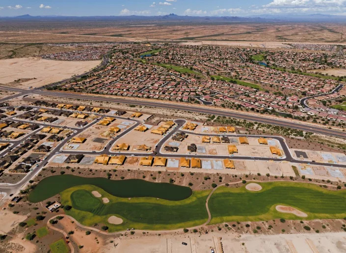
Thousands Will Live Here One Day (as Long as They Can Find Water)
Keith Schneider – December 27, 2022
A golf cart on a path at Verrado, an 8,800-acre planned community, in Buckeye, Ariz., Dec. 19, 2022. (Adriana Zehbrauskas/The New York Times)
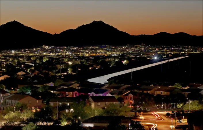
BUCKEYE, Ariz. — Surrounded by miles of creosote and ocotillo in the Sonoran Desert, state officials and business leaders gathered in October against the backdrop of the ragged peaks of the White Tank Mountains to applaud a plan to turn 37,000 acres of arid land west of Phoenix into the largest planned community ever proposed in Arizona.
The development, Teravalis, is expected to have 100,000 homes and 55 million square feet of commercial space. But to make it happen, the project’s developer, the Howard Hughes Corp., will need to gain access to enough water for its projected 300,000 residents and 450,000 workers.
Teravalis is seen by local and state leaders as a crowning achievement in a booming real estate market, but it also represents the intensifying challenge in Arizona and other fast-growing Southwestern states: to build huge mixed-use projects in an era of water scarcity.
“You can’t grow and grow on these far-flung lands and put industries anywhere you want,” said Kathleen Ferris, former director of the Arizona Department of Water Resources and a senior research fellow at the Kyl Center for Water Policy at Arizona State University. “You have to be smarter about where and how we grow.”
Persistent dry conditions are driving up the cost of water and prompting more resistance to new development. But the scarcity of water is also pushing developers to innovate with design and install expensive infrastructure to save fresh water and recycle more wastewater.
A deep drought has settled on the Southwest since 2000, exacerbated by climate change. Water flow has dropped precipitously in the Colorado River and other surface water supplies that serve Arizona and its neighboring states. That is putting more pressure to supply homes and businesses from finite water reserves held in aquifers.
The consequences are being felt across the West. A proposal for a new water pipeline to supply St. George, Utah, has become the focus of public opposition. Communities in Colorado and Utah have declared moratoriums on new developments. And water supply is one reason that rural residents are fighting a proposal to increase the density of homes in Washoe County, Nevada.
In Arizona, groundwater levels are falling so fast that thousands of residential wells all over the state are going dry. In 2021, the Arizona Department of Water Resources halted new-home construction in Pinal County, south of Phoenix, because groundwater pumping exceeded the supply.
In New Mexico, two proposals for big planned communities outside Albuquerque have languished because of concerns over water. At one project, Campbell Farming Corp. proposed building 4,000 homes, a commercial and retail center and two golf courses on 8,000 acres in the mountains east of the city more than two decades ago, according to planning documents, but it faced objections to groundwater use, which would total about 400 million to 500 million gallons annually. The Office of the State Engineer found that Campbell Ranch would not meet a New Mexico requirement for developers to demonstrate that their projects have a 70-year supply of water.
“It’s fundamental; you’re not doing that development without water,” said Kathy Freas, a co-founder of East Mountain Protection Action Coalition, a citizens’ group that opposed the plan.
Similar concerns are buffeting Santolina, a 13,700-acre planned development proposed in 2014 and still not under construction. Located between Albuquerque and the Rio Grande, Santolina is the focus of active public opposition because it would need 7.3 billion gallons of water a year to serve its projected 90,000 residents.
County officials may require Santolina’s developer, Western Albuquerque Land Holdings, to install expensive wastewater treatment and recycling infrastructure to reduce water use and waste. The company has submitted a plan that would convert hundreds of acres from housing to solar energy development, a change that would significantly reduce water consumption but could potentially require it to restart the planning process.
“In the West, water has always been an issue, right? People are just much more alert now,” said Enrico Gradi, deputy county manager for Bernalillo County, who is overseeing the review of the Santolina project.
Water scarcity is also changing the design of the Southwest’s planned communities, which no longer feature big lakes, irrigated lawns, golf courses or open drainage canals.
One example is Sterling Ranch near Littleton, Colorado, a development with roads and parks that are designed to collect and store stormwater for reuse. The 3,400-acre project will have a $350 million closed-loop water supply system that collects, treats and recycles wastewater for more than 12,500 residences, as well as commercial and retail spaces. The developers are also studying how to most efficiently collect and use rainwater from rooftops.
“Until there’s scarcity, most developers aren’t incentivized to conserve water,” said Brock Smethills, president of the site’s developer. “For us, the incentives were aligned on Day 1 to use less water and conserve as much as possible.”
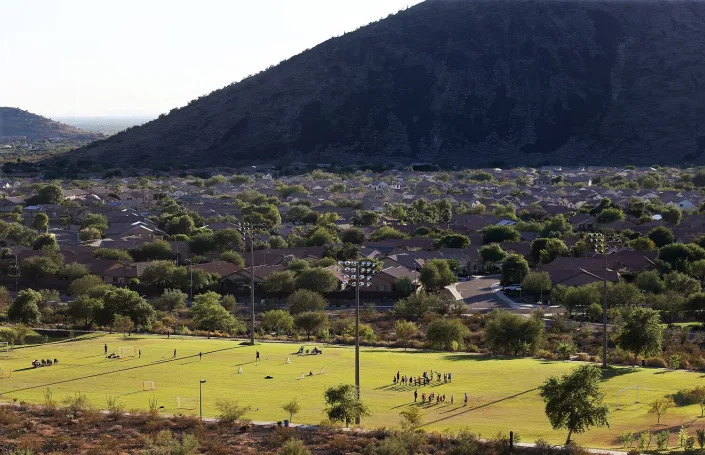
Another example is Verrado, an 8,800-acre planned community in Buckeye, Arizona, that houses 16,000 residents. Along with 30,000 trees for shade and to slow evaporation, Verrado features a water recycling system that collects all of the wastewater from homes and businesses and directs it to a treatment plant capable of recycling 1.5 million gallons a day that is stored and used to irrigate two golf courses.
“Every responsible developer in Arizona knows water is a constraint,” said Dan T. Kelly, chief operating officer and general manager for DMB Associates, the company behind Verrado. “It’s the first question you deal with.”
The intensifying attention to water supply is especially relevant to the Teravalis project. Hughes Corp. paid $600 million to purchase the property from its previous owners, who had proposed to use 3,000 acres for a planned community that would rely on the Hassayampa Basin, an aquifer beneath the project, to supply water. In 2006, the Arizona Department of Water Resources issued two certificates to supply and build 7,000 homes.
Those certificates are still valid, but Hughes Corp. does not have access to supply water to the remaining 34,000 acres — more than 90% of its property. The Department of Water Resources has put the Hassayampa Basin off limits to new development while it studies how much water the underground reserve actually holds.
Water supply options for Teravalis include tapping another aquifer and delivering water by pipeline. It could also lease water from one of Arizona’s Native American tribes that have extensive water rights.
Developers also could buy rights to Colorado River water. Queen Creek, a Phoenix suburb, secured state permission and is preparing to spend $27 million to draw from the river nearly 750 million gallons for its 66,000 residents.
The adage in the West that “water runs uphill to money” applies. This year, Arizona lawmakers approved a $1 billion, three-year appropriation, essentially a down payment to secure stable water supplies.
“We’re at the very start of a new era of innovation and investment,” said Greg Vogel, founder and CEO of Land Advisors Organization, a national brokerage and development consultancy in Scottsdale, Arizona. “Teravalis will be in the making for 50 years, maybe 70 years, until build-out. They’ll have enough water.”
By no means, though, is that a consensus view.
The city of Buckeye, where Teravalis is, uses nearly 3.5 billion gallons annually for its 115,000 residents. Water consumption by Teravalis’ 300,000 residents could amount to three times as much.
In 1980, Arizona enacted a groundwater conservation law that requires developers in the Phoenix metropolitan region to assure buyers that their homes and businesses have a 100-year water supply. The law also requires developers to replenish aquifers with the same amount of water that they withdraw.
Bruce Babbitt, a former governor of Arizona who signed the 1980 groundwater law while in office, said that Teravalis would not meet either requirement. “My conclusion, based on a lot of analysis, is the project is not viable on the scale they are talking about,” he said.
In Arizona, Colorado River crisis stokes worry over growth and groundwater depletion
Ian James – December 26, 2022
The Central Arizona Project Canal running through the desert in Arizona. (Albert Brave Tiger Lee / Los Angeles Times)
Kathleen Ferris stared across a desert valley dotted with creosote bushes, wondering where the water will come from to supply tens of thousands of new homes. In the distance, a construction truck rumbled along a dirt road, spewing dust.
This tract of open desert west of Phoenix is slated to be transformed into a sprawling development with up to 100,000 homes — a 37,000-acre property that the developers say will become Arizona’s largest master-planned community.
“It’s mind-boggling,” Ferris said. “I don’t think there is enough water here for all the growth that is planned.”
Water supplies are shrinking throughout the Southwest, from the Rocky Mountains to California, with the flow of the Colorado River declining and groundwater levels dropping in many areas. The mounting strains on the region’s water supplies are bringing new questions about the unrestrained growth of sprawling suburbs.
Ferris, a researcher at Arizona State University’s Kyl Center for Water Policy, is convinced that growth is surpassing the water limits in parts of Arizona, and she worries that the development boom is on a collision course with the aridification of the Southwest and the finite supply of groundwater that can be pumped from desert aquifers.
For decades, Arizona’s cities and suburbs have been among the fastest growing in the country. In most areas, water scarcity has yet to substantially slow the march of development.
But as drought, climate change and the chronic overuse of water drain the Colorado River’s reservoirs, federal authorities are demanding the largest reduction ever in water diversions in an effort to avoid “dead pool” — the point at which reservoir levels fall so low that water stops flowing downriver.
Already, Arizona is being forced to take 21% less water from the Colorado River, and larger cuts will be needed as the crisis deepens.
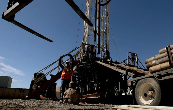
To deal with those reductions and access other supplies to serve growth, the state is turning more heavily to its underground aquifers. As new subdivisions continue to spring up, workers are busy drilling new wells.
Ferris and others warn, however, that allowing development reliant solely on groundwater is unsustainable, and that the solution should be to curb growth in areas without sufficient water.
“What we’re going to see is more and more pressure on groundwater,” Ferris said. “And what will happen to our groundwater then?”
Construction workers erect new homes in a residential development called Sun City Festival in Buckeye. Dwindling Colorado River water is delivered to central Arizona, one of the fastest growing metropolitan areas in the U.S., via the Central Arizona Project Canal. (Luis Sinco / Los Angeles Times)
One of the fastest-growing cities in the Phoenix area is Buckeye, which has plans to nearly triple its population by 2030. According to its 2020 water resources plan, 27 master-planned communities are proposed in Buckeye, which depends primarily on groundwater. If all the proposed developments are fully built, the city’s population, now 110,000, would skyrocket to about 872,000.
In the area Ferris visited, construction has begun on the giant development called Teravalis, where the developers plan to build the equivalent of a new city, complete with more than 1,200 acres of commercial development.
State water regulators have granted approvals to allow an initial portion of the project to move forward. But in other nearby areas of Buckeye, state officials have sent letters to builders putting some approvals on hold while they study whether there is enough groundwater for all the long-term demands.
The sun sets on the vast desert landscape along Sun Valley Parkway in Buckeye, Ariz. (Luis Sinco/Los Angeles Times)
“It’s hard for me to imagine wall-to-wall homes out here,” Ferris said, standing on the gravel shoulder of the Sun Valley Parkway, which runs across miles of undeveloped land. “This is the epitome of irresponsible growth. It is growing on desert lands, raw desert lands, where there’s no other water supply except groundwater.”
Nearby, the Central Arizona Project snakes through the desert, filled with Colorado River water. The CAP Canal was built between 1973 and 1993, bringing water that has enabled growth. But its supply came with low-priority water rights that made it vulnerable to cuts in a shortage.
The Phoenix metropolitan area’s population has more than doubled since 1990, expanding from 2.2 million to about 4.9 million people. Subdivisions have been built on former farmlands as development has expanded across the Salt River Valley, also called the Valley of the Sun.
Ferris, a lawyer and former director of the Arizona Department of Water Resources, helped draft the state’s 1980 Groundwater Management Act, which was intended to address overpumping and has since regulated groundwater use in urban areas.
Water from the CAP Canal has enabled cities to pump less from wells. For years, they have banked some of the imported Colorado River water underground by routing it to basins where it percolates down to aquifers.
The Central Arizona Project Canal runs beside a community in the suburbs of North Phoenix. Development projects envisioning thousands of new homes around Phoenix now are in question because of lack of water. (Luis Sinco / Los Angeles Times)
The state requires that new developments around Phoenix and other urban areas have a 100-year “assured water supply,” based on a calculation that allows for groundwater to be pumped down to a level 1,000 feet underground. Changes by the Legislature and regulators in the 1990s cleared the way for subdivisions to rely on groundwater as an assured water supply.
Since then, a groundwater replenishment district has been charged with securing water and using it to recharge aquifers, creating an accounting system. The problem with this system, Ferris said, is that groundwater has been overallocated, allowing for excessive pumping in some areas.
“We’ve got to learn to live within our means. Groundwater was always supposed to be a savings account, to be used only in times of shortages. Well, now those shortages look permanent,” Ferris said. “We ought to be saying, ‘How much growth can we really sustain?’ And put limits on how much water we’re going to use.”
The desert aquifers contain “fossil” water that has been underground for thousands of years.
“That water is not replenished. And so once it’s pumped, it’s pretty much gone,” Ferris said.
In recent years, Arizona has received about 36% of its water from the Colorado River. The river has long been severely overallocated, and its flows have shrunk dramatically during 23 years of megadrought intensified by global warming.
One of a growing number of developments in Buckeye, Ariz., that depend on groundwater. (Albert Brave Tiger Lee / Los Angeles Times)
The river’s largest reservoirs, Lake Mead and Lake Powell, now sit nearly three-fourths empty. Federal officials have warned there is a real danger the reservoirs could drop so low by 2025 that water would no longer flow past Hoover Dam to Arizona, California and Mexico.
Ferris said Arizona now needs to plan for years with little or no Colorado River water. She said she feels sad and angry that federal and state water managers, despite warnings by scientists, failed to act sooner to address the shortage.
“The Colorado River is dying,” Ferris said. “It is dying from overallocation, overuse, aridification, mismanagement.”
In the same way that tough decisions about the Colorado River were neglected for years, she said, “we’re not managing our groundwater well.”
“Either we do something about this now or we pay the consequences later. And we’re paying the consequences now with the Colorado River, because we didn’t deal with those problems soon enough,” Ferris said. “If we fail to plan for the idea that our groundwater will no longer be sufficient, then shame on us.”
Alongside the river’s decline, the Southwest is undergoing a parallel crisis of groundwater depletion. Scientists found in a 2014 study, using measurements from NASA satellites, that pumping depleted more than 40 million acre-feet of groundwater in the Colorado River Basin over nine years, about 1.5 times the maximum capacity of Lake Mead.
The sun sets on the vast desert landscape along Sun Valley Parkway in Buckeye, Ariz. (Luis Sinco / Los Angeles Times)
“Our research has shown that the groundwater in the lower basin has been disappearing nearly seven times faster than the combined water losses from Lakes Powell and Mead,” said Jay Famiglietti, a hydrology professor and executive director of the University of Saskatchewan’s Global Institute for Water Security. “Groundwater losses of that magnitude are literally an existential threat to desert cities like Phoenix and Tucson.”
Next year, Arizona’s allocation of Colorado River water delivered through the CAP Canal will be cut by more than a third. Some Arizona farmers are losing their CAP supplies, while irrigation districts are drilling new state-funded wells.
Arizona’s cities have yet to see major reductions. But that could soon change.
Ferris said she thinks growth should happen in areas where sufficient water is available, and from multiple sources.
A workman prepares a rig to drill for water in the suburbs of Phoenix. Colorado River flows are at historic lows due to warmer and drier conditions caused by climate change. (Luis Sinco / Los Angeles Times)
The city of Peoria, northwest of Phoenix, is one example of an area with a variety of sources, including the Colorado River, the Salt and Verde rivers and recycled wastewater. Since 1996, the city has been banking water underground, storing treated wastewater effluent and a portion of its Colorado River water.
The city is now drilling wells to pump out some of those supplies.
“Even if the Colorado River went away completely, we expect to have enough water banked underground to last us for years,” said Cape Powers, Peoria’s water services director. “We’ll continue to prepare for whatever comes our way.”
Nearby, a drilling crew was preparing to bore one of eight new wells for the city.
“Every drill rig that my company has is spoken for until May or June of next year,” said Ralph Anderson, the owner of Arizona Beeman Drilling. “The business in the next 3 to 5 years is going to just go through the roof.”
Some cities are maneuvering in other ways, reaching outside the Phoenix area to secure water.
The growing Phoenix suburb of Queen Creek recently won approval for a controversial $22-million deal to buy water rights from an investment company that will leave farmland dry in the community of Cibola, next to the Colorado River.
Queen Creek has also signed a 100-year contract to pay landowners $30 million to leave farmland fallow in the rural Harquahala Valley west of Phoenix, allowing them to pump groundwater and ship it to the suburbs.
Other cities are also looking to pump groundwater in the Harquahala Valley and other areas where they would be allowed to transport the water by canal.
Landscaped yards and green grassy playing fields typify the suburbs of North Phoenix. (Luis Sinco / Los Angeles Times)
Buckeye has a substantial amount of groundwater locally and plans to seek additional water that could be brought in from other areas, said Terry Lowe, the city’s director of water resources.
“It’s a hot market, the Phoenix metro area in general, and we’ve got to be able to have that water to meet that demand,” Lowe said. “And so we’re looking at working with others outside to find sources.”
For the planned 37,000-acre community Teravalis, the developers have two existing water approvals, called certificates of assured water supply, to build about 7,000 homes, and plan to seek additional approvals to build more. The developers plan to pump groundwater from the aquifer beneath the property, which lies in the Hassayampa River watershed.
“It’s one of the most plentiful aquifer basins in the state of Arizona. So we feel pretty good about that,” said Heath Melton, regional president for The Howard Hughes Corp. “We feel like we’re in a really good place.”
Melton said the community will conserve water by having low-water-use plants and fixtures, and will use recycled wastewater for outdoor irrigation and to recharge the aquifer.
Developers are also supporting the state government’s efforts to secure additional water from new sources.
Colorado River water flows into the Agua Fria groundwater recharge basins (or groundwater recharge facilities) in Peoria, Ariz. (Albert Brave Tiger Lee / Los Angeles Times)
Legislation signed this year by Gov. Doug Ducey established a new Water Infrastructure Finance Authority that will have about $1.4 billion for conservation projects and to secure additional supplies, including possibly bringing in water from outside the state. Arizona officials have been looking into a possible deal with Mexico to desalinate seawater at the Sea of Cortez and exchange that water for some of Mexico’s Colorado River water.
In the Hassayampa watershed in Buckeye, state water regulators have been working on an updated analysis of the groundwater basin. In letters to some other developers in the area, they have warned that although their report is not yet complete, they have “information indicating that the proposed subdivision’s estimated groundwater demand for 100 years is likely not met when considered with other existing uses and approved demands in the area.”
The Arizona Department of Water Resources similarly announced in 2019 that projections showed insufficient groundwater available for all the planned developments in Pinal County, between Phoenix and Tucson.
“The amount of groundwater we can allocate for these purposes is finite,” said Tom Buschatzke, the department’s director. He said in the Hassayampa basin, all the proposed developments won’t be able to grow on groundwater alone.
“They’ve got to find a different way to do business than what they’ve historically done,” he said. “They’ve got to find different pathways, more likely more expensive pathways.”
Buschatzke said the area still has options, such as bringing in water from other areas or using recycled water.
Even as the supply of Colorado River water shrinks, some researchers are optimistic about the state’s ability to adapt.
“The whole state is at an inflection point where we have to take some definite actions toward making sure of water supplies to serve the populations that are here now and into the future,” said Sarah Porter, director of ASU’s Kyl Center for Water Policy. “Arizona has a long history of meeting these water challenges, and I think Arizona will do that again.”
Ferris said she feels more pessimistic.
Homes are being built in a new community in Buckeye, Ariz. (Albert Brave Tiger Lee / Los Angeles Times)
Visiting a new development in Buckeye, Ferris drove past an entrance with flowing fountains. She watched workers building homes beside a golf course with ponds.
Nearby, new homes stood beside the open desert. On empty lots, flattened patches of dirt lay ready for the foundations to be poured.
“We have to stop growing these giant developments on groundwater. It is unsustainable,” Ferris said. “We need to limit the growth.”
Colorado River Basin policymakers stand at a critical juncture. They have an opportunity to avert more severe impacts of the crisis by implementing policy and management changes that go beyond the relatively incremental steps taken thus far.
How do we find long-term sustainability?
However, negotiating such major changes is extremely challenging, especially given the basin’s complex legal structure of water rights, its users’ diverse demands and uncertainty around how much water will be available in the future.
This raises the question: How can basin policymakers create transformational change that advances the long-term sustainability of the Colorado River amid this crisis?
A buoy sits high and dry on cracked earth previously under the waters of Lake Mead at the Lake Mead National Recreation Area near Boulder City, Nev., on June 28, 2022. Living with less water in the U.S. Southwest is the focus for a conference starting Wednesday, Dec. 14, 2022, in Las Vegas, about the drought-stricken and overpromised Colorado River.
First, policymakers must stabilize the Colorado River system, meaning that water use does not exceed water availability. However, because streamflow is expected to continue to decline as temperatures rise, any stabilization solution must be adaptable to changes in water availability as they occur.
One way to achieve this is to change the indicators of system-wide water availability that trigger water management actions. Basin managers currently use slow-responding reservoir levels (which may also be muddled by complex water accounting) for this purpose. A more responsive indicator, such as a 5-year rolling average of inflow, could be used in the short term to minimize reliance on dwindling storage.
In the longer term, Basin managers could also consider an adaptive approach used in other areas of the West that converts fixed-quantity water rights to shares of the total quantity of available water, with the allocation of shares tailored to account for the existing water rights priority structure. The total quantity of available water could be adjusted to slowly refill reservoirs, serving to mitigate large water cuts in dry years. This additional step would help the system move beyond stabilization and into longer-term recovery.
2. Prioritize ideas to reduce uncertainty
Moving to the type of management regime described above will likely mean painful cuts for water users throughout the Colorado River Basin in the coming years. However, it could create more predictability and reliability in the long term – values that Basin managers have previously signaled agreement around.
Managing for a smaller known quantity of water is often easier than managing for the unknown. Achieving this, however, requires that all water users, including historically marginalized tribes and environmental groups, have an equitable seat at the negotiating table in order to reduce uncertainty about future water uses and needs.
3. Think beyond ‘how to share water cuts’
Finally, policymakers must expand their conception of “water sustainability” in the Colorado River Basin. For thriving communities and economies, water is a means, not an end. Beyond water use directly for human, public and ecological health, water enables food production and energy generation.
Broadening our thinking from “how to share water reductions” to “how to maintain regional food and energy security” opens new opportunities for negotiation and collaboration beyond the traditional “zero-sum” mentality.
These could include investing recently allocated federal funds for drought mitigation in improving agricultural water use efficiency, supporting the clean energy transition and conserving ecosystems to achieve more holistic sustainability goals, rather than temporarily buying more time through short-term conservation measures.
Transforming Colorado River Basin management to mitigate the current water crisis and realize long-term water sustainability requires changing not only policies but also the way we think about water use and needs.
The three suggestions presented above can help policymakers to meet this moment of historic challenge and historic opportunity by moving beyond incremental change and fostering a new era of solutions for the Colorado River.
Margaret Garcia, Ph.D, is an assistant professor in the School of Sustainable Engineering and the Built Environment at Arizona State University. Elizabeth A. Koebele, Ph.D., is an associate professor of political science at the University of Nevada, Reno, where she researches the use and implications of collaborative approaches to governing water resources.
Arizona’s water crisis is manageable – if we actually do these 3 things
Grady Gammage, Jr. – December 22, 2022
Those of us who talk about Arizona’s water situation often point out that the challenge we face is less daunting than other dilemmas of climate change like sea level rise or an increasing frequency of hurricanes. A dramatic decline in water resources, we say, is manageable, and Arizona has a strong history of water management.
But there’s a catch: We have to actually manage it.
There are a lot of seemingly disconnected ideas floating around. It is important to fit these ideas into a context, and to give Arizonans a way to talk about how we will manage our way through.
Here are some thoughts on such a framework.
Conservation is a small yet critical need
We cannot conserve our way out of the looming shortages. Reducing turf, limiting lot sizes and increasing use of effluent are all good and important things. The reality is we could shut off all municipal use and not solve the problem.
Conservation is an important piece of reminding everyone how critical water is, and of making a statement that we are serious and we are all in this together. Conservation would involve some mandates (like prohibiting winter overseeding); incentives (paying to remove turf) and a lot of education.
The best way to achieve conservation is to create targets for municipal reductions in per-capita consumption. The best way of reaching those targets is to carefully raise water prices on amounts beyond a minimum quantity per household.
This represents action we can take immediately.
Shift water from agriculture to urban use
Arizona must incentivize farmers to increase efficiency and be more flexible in crop choices.
The biggest water use in Arizona by far is irrigated agriculture. Encouraging farming was the goal of public policy to settle the West. That worked, but today the policy should be to first preserve western economies and urban growth.
Agriculture does not need to disappear. But it needs to dramatically curtail use when there is not enough water to go around.
We must compensate farmers for such changes, and incentivize them to increase efficiency and be more flexible in crop choices. Farmers in Yuma have offered such a proposal, which can become the basis for negotiation. This should be the primary use of state dollars through the newly enhanced Water Infrastructure Financing Authority (WIFA). The Legislature put a billion dollars into WIFA in 2022. A good start, but there needs to be an ongoing revenue stream for these purposes.
Just as an example, a $500 surcharge per acre foot of municipal water use in Maricopa County would raise about half a billion dollars every year. That amounts to $.0015 per gallon. Carefully shifting water from farming to urban use can get us through the next 30-40 years.
Invest in new, long-term water sources
It is important to start working now on solutions in the distant horizon. This likely means ocean desalinization, but there may be other alternatives. What is important is that a plan for 50-plus years into the future begins to unfold.
The price tag will be high. The recent Build Back Better bill has about $4 billion earmarked for Western water projects. This is great, and we should thank our congressional delegation.
Federal participation in dealing with the cost of natural disasters is a bedrock purpose of the national government. It is a way of spreading the risk of hurricanes, floods and fires over a larger revenue base. It is also a way of protecting interstate commerce. New York City alone got $4 billion in federal money after “Superstorm” Sandy.
The federal government has averaged more than $30 billion per year in hurricane relief since 2000. Drought and aridification in the West are the same sort of challenge.
The Colorado River basin states should band together to make this point in Washington. Federal reclamation policy settled the West. That policy is now needed to sustain what reclamation built.
Confronting the challenge of a drying climate at different scales and in different time frames will help Arizona reassert its storied history of leadership in water management.
Grady Gammage, Jr. is a practicing lawyer and author.
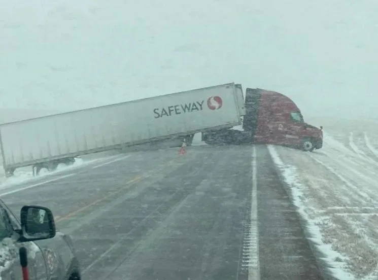
Thousands trapped on Pine Ridge burn clothes for warmth in wake of storm
Darsha Dodge – December 22, 2022
With a twinge of cold in her toes and a tone of concern tinted by exhaustion, Anna Halverson relayed the message: “We’re in a really extreme emergency down here.
Winter Storm Diaz blanketed the Pine Ridge Reservation in more than 30 inches of snow – incredible enough on its own – but it was amplified by intense winds that brought the area to a standstill under drifts of snow several feet high.
A semi truck and trailer blocking a major highway on the Pine Ridge Reservation during Winter Storm Diaz.
Halverson, who represents the Pass Creek District on the Pine Ridge Reservation, described their harrowing situation to the Journal on Thursday.
“It’s been really tough,” she said. “We don’t have the proper equipment here to handle what’s been going on. We have drifts as high as some houses that stretch 60, 70 yards at a time.”
More than 10 days since the storm began, Diaz has moved on and the skies have started to clear, but the recovery process is just beginning. Halverson didn’t get dug out of her house until eight days after the storm. Others are still trapped, reachable only by snowmobile.
It seems like every time we open the road, the snow just drifts it back over,” she said.
It’s an incredibly scary situation, she explained, as many of those snowed-in are missing dialysis treatments or dealing with other medical emergencies. One family ran out of infant formula, and spent four days drifted in before attempting to leave, Halverson said.
“We even talked about using drone drops to get the baby some Enfamil, because the baby was starving,” she said.
But Mother Nature wasn’t done yet.
If being trapped by formidable walls of ice and snow wasn’t enough, subzero temperatures, brought down by an Arctic front, took an already struggling region by the neck. Temperatures dropped into the negative teens and 20s this week, and the unkind Midwest wind shredded those figures with wind chills in the negative 40s and negative 50s.
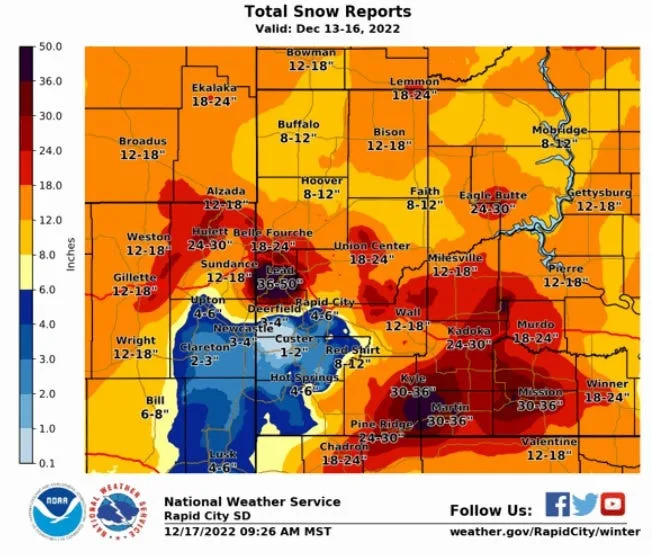
Total snow reports from Dec. 13 – 16 in Western South Dakota
Cold like that is deadly, just another blow to a reservation already crippled by conditions, Halverson said.
“Most of our members use wood stoves,” she said. “We’re not able to get them with deliveries because of the roads. A lot of our members across the reservation have no propane, because the propane companies can’t reach their tanks to fill. Even right now in my district, we haven’t had anybody able to deliver out to these members that have no propane since the storm started.”
Oglala-based service organization Re-Member provides firewood to families on all corners of the reservation, but the drifts of snow have rendered their wood stockpile inaccessible still – and it’ll be that way for the foreseeable future.
“Our wood pile remains inaccessible,” read a Facebook post on Dec. 20. “Our skid steer and plow are out-of-service. Given the conditions, it would be near impossible to operate our equipment and unsafe for our staff to work in the conditions we are facing. We appreciate the efforts being made by many to keep the Oyate safe during these challenging times.”
Those that can try to use electric heaters, which Halverson said isn’t keeping houses warm. Even her own furnace went out, blowing cold air in an already frigid atmosphere. She was able to travel to her mother’s house to keep her family warm.
Power went out in some places, once for 18 hours, she said. People with cars tried to use them to stay warm.
Reservation residents are resorting to last-ditch efforts to ward off the unimaginable cold.
“I’ve seen across the reservation some members were burning clothes in their wood stove because they couldn’t get access to wood,” Halverson said.
The conditions got so bad so quickly that Oglala Sioux Tribe President Frank Star Comes Out penned a proclamation declaring a state of emergency.
“These current blizzard conditions have caused closure of all BIA and tribal secondary roads on the reservation due to falling snow, high winds and snow drifts,” Star Comes Out wrote. “Such blizzard conditions pose an imminent threat to tribal government operations, to public safety and the health of tribal members who currently do not have access to medical care, such as dialysis, ambulance service for crisis intervention medical care such as heart attacks and delivering babies, and private transportation to secure food and other necessities of life.”
Halverson praised his efforts in trying to get help for the people of Pine Ridge. The exhaustion in her voice dissipated – for a brief second – calling her people “survivors.”
“We don’t live on our reservation,” she said. “We survive on our reservation. We’re in serious need of some help.”
What’s the coldest spot on Earth? NASA has pinpointed it — and the nights are deadly
Mark Price – December 19, 2022
NASA image
If you think a little cold air and snow might bolster your holiday spirits, NASA says it knows the perfect destination for frigid Christmas and New Year’s celebrations.
“Looking for the coldest place to spend the holiday season?” the space agency asked in a Facebook post.
“You won’t find anyone else there, but the coldest place we’ve found on Earth (with the help of NASA Earth satellites) is a high ridge on the East Antarctic Plateau.”
Just be sure to bundle up. Temperatures on the ridge “can drop to 135 degrees (Fahrenheit) below zero” on winter nights, NASA says.
NASA first reported finding the planet’s coldest spot in 2013, and the plateau has continued to hold the dubious honor every year since.
The National Snow and Ice Data Center concluded the East Antarctic Plateau was the coldest place in the world after analyzing 32 years of data from several satellites, NASA says. The hollows on the plateau are considered the coldest spots.
“Near a high ridge that runs from Dome Arugs to Dome Fuji, the scientists found clusters of pockets that have plummeted to record low temperatures dozens of times,” officials reported. “The lowest temperature the satellites detected – minus 136° F (minus 93.2° C), on Aug. 10, 2010.”
Scientists attribute the plateau’s dangerous temperatures to a combination of air that is “stationary for extended periods, while continuing to radiate more heat away into space.”
However, the plateau is not “the coldest permanently inhabited place on Earth,” experts say. That’s located in northeast Siberia, “where temperatures dropped to a bone-chilling 90 degrees below zero F (minus 67.8° C) in the towns of Verkhoyansk (in 1892) and Oimekon (in 1933).”
‘It could happen tomorrow’: Experts know disaster upon disaster looms for West Coast
Joel Shannon, USA TODAY – December 19, 2022
It’s the elevators that worry earthquake engineering expert Keith Porter the most.
Scientists say a massive quake could strike the San Francisco Bay Area at any moment. And when it does, the city can expect to be slammed with a force equal to hundreds of atomic bombs.
To escape, the survivors of the initial quake will need the help of firefighters with specialized training and tools.
But their rescuers won’t come – at least not right away. Firefighters will be battling infernos that could outnumber the region’s fire engines.
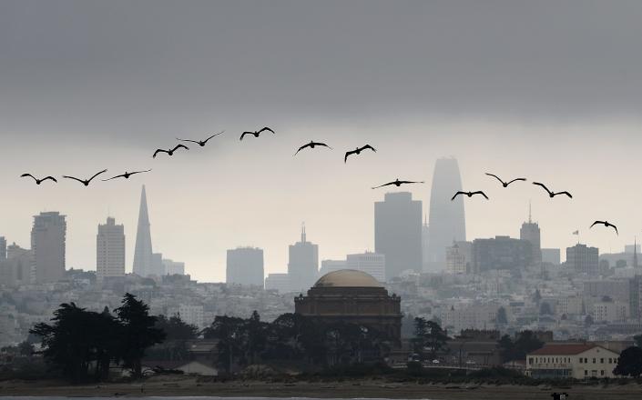
Brown pelicans fly in front of the San Francisco skyline Aug 17, 2018.
Running water will be in short supply. Cellphone service may not work at all. The aftershocks will keep coming.
And the electricity could remain off for weeks.
“That means people are dead in those elevators,” Porter said.
‘Problems on the horizon’
The situation Porter described comes from his work on the HayWired Scenario, a detailed look at the cascading calamities that will occur when a major earthquake strikes the Bay Area’s Hayward Fault, including the possibility of widespread power outages that will strand elevators.
The disaster remains theoretical for now. But the United States Geological Survey estimates a 51% chance that a quake as big as the one described in HayWired will occur in the region within three decades.
It’s one of several West Coast disasters so likely that researchers have prepared painstakingly detailed scenarios in an attempt to ready themselves.
The experts who worked on the projects are highly confident the West Coast could at any moment face disasters with the destructive power to kill hundreds or thousands of people and forever change the lives of millions more. They also say there’s more that can be done to keep individuals – and society – safer.
“We’re trying to have an earthquake without having one,” Anne Wein told USA TODAY. Wein is a USGS researcher who co-leads the HayWired earthquake scenario and has worked on several other similar projects.
Such disaster scenarios are massive undertakings that bring together experts from various fields who otherwise would have little reason to work together – seismologists, engineers, emergency responders and social scientists.
That’s important because “it’s difficult to make new relationships in a crisis,” Wein said.
Similar projects aimed at simulating a future disaster have turned out to be hauntingly accurate.
The Hurricane Pam scenario foretold many of the devastating consequences of a major hurricane striking New Orleans well before Hurricane Katrina hit the city.
More recently, in 2017, the authors of “The SPARS Pandemic” called their disaster scenario “futuristic.” But now the project now reads like a prophecy of COVID-19. Johns Hopkins University even issued a statement saying the 89-page document was not intended as a prediction of COVID-19.
“The SPARS Pandemic” imagined a future where a deadly novel coronavirus spread around the world, often without symptoms, as disinformation and vaccine hesitancy constantly confounded experts’ efforts to keep people safe.
The “SPARS scenario, which is fiction, was meant to give public health communicators a leg up … Think through problems on the horizon,” author Monica Schoch-Spana told USA TODAY.
At the time that SPARS was written, a global pandemic was thought of in much the same way experts currently describe the HayWired earthquake: an imminent catastrophe that could arrive at any time.
‘It could happen tomorrow’
Disaster scenario researchers each have their own way of describing how likely the apocalyptic futures they foresee are.
“The probability (of) this earthquake is 100%, if you give me enough time,” seismologist Lucy Jones will often say.
Earthquakes occurring along major faults are a certainty, but scientists can’t predict exactly when earthquakes will happen – the underground forces that create them are too random and chaotic. But researchers know a lot about what will happen once the earth begins to shake.
Earthquakes like HayWired are “worth planning for,” Porter said. Because “it could happen tomorrow.”
“We don’t know when,” Porter said. But “it will happen.”
Wein says we’re “overdue for preparedness.” You might say we’re also overdue for a major West Coast disaster.
The kind of earthquake described in HayWired historically occurs every 100-220 years. And it’s been more than 153 years since the last one.
Farther south in California, it’s difficult to pin down exactly how at risk Los Angeles is for The Big One – the infamous theoretical earthquake along the San Andreas fault that will devastate the city. But a massive magnitude 7.5 earthquake has about a 1 in 3 chance of striking the Los Angeles area in the next 30 years, the United States Geological Survey estimates.
Another scenario warns that a stretch of coast in Oregon and Washington state is capable of producing an earthquake much more powerful than the ones California is bracing for. Parts of coastline would suddenly drop 6 feet, shattering critical bridges, destroying undersea communication cables and producing a tsunami.
It too “could happen at any time,” the scenario says.
Earthquake scenarios often focus on major coastal cities, but West Coast residents farther inland also have yet another disaster to brace for.
“Megastorms are California’s other Big One,” the ARkStorm scenario says. It warns of a statewide flood that will cause more than a million evacuations and devastate California’s agriculture.
Massive storms that dump rain on California for weeks on end historically happen every few hundred years. The last one hit around the time of the Civil War, when weeks of rain turned portions of the state “into an inland sea.”
‘Decades to rebuild’
Whether the next disaster to strike the West Coast is a flood, an earthquake or something else, scenario experts warn that the impacts will reverberate for years or longer.
“It takes decades to rebuild,” Wein said. “You have to think about a decade at least.”
A major West Coast earthquake isn’t just damaged buildings and cracked roads.
It’s weeks or months without running water in areas with millions of people. It’s mass migrations away from ruined communities. It’s thousands of uninhabitable homes.
Depending on the scenario, thousands of people are expected to die. Hundreds of thousands more could be left without shelter. And those impacts will be a disproportionately felt.
California already has a housing and homelessness crisis, and Nnenia Campbell said the next disaster is set to magnify inequalities. Campbell is the deputy director of the William Averette Anderson Fund, which works to mitigate disasters for minority communities.
Campbell doesn’t talk about “natural disasters” because there’s nothing natural about the way a major earthquake will harm vulnerable communities more than wealthy ones.
Human decisions such as redlining have led to many of the inequities in our society, she said. But humans can make decisions that will help make the response to the next disaster more equitable.
Many of those choices need to be made by local leaders and emergency management planners. Investing in infrastructure programs that will make homes in minority communities less vulnerable to earthquakes. Understanding how important a library is to unhoused people. Making sure all schools are built to withstand a disaster. Keeping public spaces open, even during an emergency.
But individuals can make a difference as well, Campbell said. You can complete training that will prepare you to help your community in the event of an emergency. Or you can join a mutual aid network, a group where community members work together to help each other.
Community support is a common theme among disaster experts: One of the best ways to prepare is to know and care about your neighbors.
If everyone only looks out for themselves in the next disaster, “we are going to have social breakdown,” Jones said.
What you can do
Experts acknowledge you’ll want to make sure you and your family are safe before being able to help others. Fortunately, many disaster preparedness precautions are inexpensive and will help in a wide range of emergency situations.
Be prepared to have your access to electricity or water cut off for days or weeks.
For electricity, you’ll at least want a flashlight and a way to charge your phone.
While cell service will be jammed immediately after a major earthquake, communications will likely slowly come back online faster than other services, Wein said. (And when trying to use your phone, text – don’t call. In a disaster, text messages are more reliable and strain cell networks less.)
To power your phone, you can cheaply buy a combination weather radio, flashlight and hand-crank charger to keep your cell running even without power for days.
A cash reserve is good to have, too, Jones said. You’ll want to be able to buy things, even if your credit card doesn’t work for a time.
Preparing for earthquakes specifically is important along the West Coast, too, experts said. Simple things like securing bookshelves can save lives. Downloading an early warning app can give you precious moments to protect yourself in the event of a big quake. Buying earthquake insurance can protect homeowners. And taking part in a yearly drill can help remind you about other easy steps you can take to prepare.
There’s even more you could do to ready yourself for a catastrophe, but many disaster experts are hesitant to rely on individuals’ ability to prepare themselves.
Just as health experts have begged Americans to use masks and vaccines to help keep others safe during the pandemic, disaster scenario experts believe community members will need to look out for one another when the next disaster strikes.
Telling people to prepare as if “nobody is coming to help you” is a self-fulfilling prophesy, Jones said.
For now, policymakers hold the real power in how prepared society will be for the next disaster. And there are many problems to fix, according to Porter, including upgrading city plumbing, because many aging and brittle water pipes will shatter in a major earthquake, cutting off water to communities for weeks or months.
Catrin Einhorn and Lauren Leatherby – December 16, 2022
Animals Are Running Out of Places to Live
Wildlife is disappearing around the world, in the oceans and on land. The main cause on land is perhaps the most straightforward: Humans are taking over too much of the planet, erasing what was there before. Climate change and other pressures make survival harder.
This week and next, nations are meeting in Montreal to negotiate a new agreement to address staggering declines in biodiversity. The future of many species hangs in the balance.
“If the forest disappears, they will disappear,” said Walter Jetz, a professor of biodiversity science at Yale University who leads Map of Life, a platform that combines satellite imaging with ecological data to determine how species ranges are changing around the world. Map of Life shared data with The New York Times.
Biodiversity — or all the variety of life on the planet, including plants, invertebrates and ocean species — is declining at rates unprecedented in human history, according to the leading intergovernmental scientific panel on the subject. The group’s projections suggest that 1 million species are threatened with extinction, many within decades.
The meeting in Montreal is intended to chart a different path. Delayed two years because of the pandemic, delegations are working to land a new, 10-year agreement to tackle biodiversity loss under a United Nations treaty called the Convention on Biological Diversity.
“With our bottomless appetite for unchecked and unequal economic growth, humanity has become a weapon of mass extinction,” U.N. Secretary-General António Guterres said in his opening remarks last week in Montreal.
The last global biodiversity agreement failed to meet a single target at the global level, according to the Convention on Biological Diversity itself, and wildlife populations continue to plummet.
Take the Honduran white bat.
At first glance, they resemble a cluster of cotton balls stuck under a leaf. But each tiny mound of fluff possesses an even tinier yellow snout and ears. Honduran white bats work together to fashion leaves into tent homes and are known to nurse one another’s young. At night, they fly out in search of a specific species of fig, dispersing its seeds in return.
These bats offer potential benefits to people. Their cuteness makes them an ecotourism draw, and they have an ability that’s rare in mammals to store carotenoids in their skin, which could hold promise for unlocking treatment for conditions such as macular degeneration.
But in the past 20 years, Honduran white bats have lost about half their range in Central America as people clear rainforest for pasture, crops and homes. Not yet considered endangered, they are nevertheless in steep decline, one of countless examples in this worsening global crisis.
It’s not only wildlife that will suffer as a result. Biodiversity loss can trigger ecosystem collapse, scientists say, threatening humanity’s food and water supplies. Alarm is growing that the threat is comparable in significance to the climate crisis.
“Climate change presents a nearer-term threat to the future of human civilization,” said Katharine Hayhoe, a prominent climate change researcher who also focuses on biodiversity as chief scientist at the Nature Conservancy. “The biodiversity crisis presents a longer-term threat to the viability of the human species.”
Scientists emphasize that one can’t be solved without the other because they are interconnected.
What Is Driving the Loss
The human population has doubled since 1970. Although the rate of population growth is slowing, the sheer number of people continues to rise. Consumption levels in different parts of the world mean some people put more pressure on nature. In the United States, for example, each person uses the equivalent of 8 global hectares on average, according to the Global Footprint Network, a nonprofit research group. In Nigeria, it’s about 1 hectare per person.
All that is related to the causes of biodiversity loss, which scientists have ranked. First are changes in land and sea use. Then comes the direct taking of species via, for example, hunting, fishing and wildlife trafficking. Climate change is next, followed by pollution and invasive species. Unfortunately for wildlife, these pressures build on one another.
In the future, scientists expect climate change to become the main driver of biodiversity loss as changes in temperature, rainfall and other conditions continue to transform ecosystems. That shift is expected “some decades down the road,” Jetz said. “But we might already be looking at a much-reduced set of species at that point.”
For the best chance at adapting to climate change, plants and animals need robust populations and room to migrate. Instead, they are depleted and hemmed in.
Why are people taking over so much land? Mostly for agriculture. In many parts of the world, that means exports driven by booming global trade. In recent decades, for example, Southeast Asia has become a major supplier of coffee, timber, rice, palm oil, rubber and fish to the rest of the world.
“All of that economic expansion has come at the cost of biodiverse habitat,” said Pamela McElwee, an environmental anthropologist at Rutgers University who studies the region.
Some momentum is building for companies to ensure that their products are deforestation-free. Reducing meat consumption and food waste are key to freeing up land for other species, McElwee said.
In many places, poverty, powerful interests and a lack of law enforcement make habitat loss especially hard to address.
In Central America, illegal cattle ranching drives deforestation on protected state and Indigenous lands, said Jeremy Radachowsky, director for Mesoamerica and the Caribbean at the Wildlife Conservation Society. Wealthy individuals, often affiliated with drug cartels, grab land, sometimes through illegal payments. They raise beef, some of which ends up in the United States, he said.
Elsewhere in the region and beyond, desperation sometimes pushes people to find remote areas with little government presence where they can simply take land to make a living.
“They need land in order to feed their families,” said David López-Carr, a professor of geography at the University of California Santa Barbara who studies how people interact with tropical forests in Latin America.
Rainforest countries such as Brazil and Congo are known for widespread deforestation. But the species that have lost the largest portions of their habitats tend to be concentrated in places that are geographically isolated in some way, such as the isthmus of Central America and Madagascar. Because animals there often have smaller ranges to begin with, habitat loss hits them especially hard.
For example, 98% of lemurs, primates that only exist in Madagascar, are threatened. Almost one-third are on the brink of extinction. “I don’t want to lose my hope,” said Jonah Ratsimbazafy, a primatologist who leads a nonprofit group on the island that seeks to save lemurs while helping people. Madagascar is among the poorest countries in the world.
Recognition is growing that stanching biodiversity loss requires addressing the needs of local communities.
“There needs to be a way that the people that live close to the forests benefit from the intact forests, rather than clearing the forest for short term gain,” said Julia Patricia Gordon Jones, a professor of conservation science at Bangor University in Wales. “That’s the ultimate challenge of forest conservation globally.”
The High Cost of Inaction
While countries in the global south are experiencing the most dramatic biodiversity losses right now, Europe and the United States went through their own severe declines hundreds of years ago.
“We lost pretty much 100% of primary forest in most parts of Europe,” Jetz said.
Now, with negotiations underway in Montreal, countries that are poor economically but rich in biodiversity argue that they need help from wealthier countries if they’re going to take a different route.
Overall, the financial need is daunting: hundreds of billions per year to help poorer countries develop and implement national biodiversity plans, which would include actions such as creating protected areas; restoring degraded lands; reforming harmful agricultural, fishing and forestry practices; managing invasive species; and improving urban water quality.
On the other hand, failing to address biodiversity loss carries enormous financial risk. A report by the World Economic Forum found that $44 trillion of economic value generation is “moderately or highly dependent on nature and its services and is therefore exposed to nature loss.”
A vast source of funding could come from redirecting subsidies that presently support fossil fuels and harmful agricultural practices, said David Cooper, deputy executive secretary of the Convention on Biological Diversity.
“Currently, most governments spend far more on subsidies that actually are destroying nature than they do on financing conservation,” Cooper said. “So, certainly a change in that will be critical.”
The United States is the only country besides the Holy See that isn’t a party to the convention, so although the United States will attend the meeting, it will be participating from the sidelines.
“We can play a very constructive role from the outside,” said Monica Medina, an assistant secretary of state who is also special envoy for biodiversity and water resources. But she acknowledged that being a member would be better. “I hope that someday we will be,” she said.
Of the many targets being negotiated, the one that has gotten the most attention seeks to address habitat loss head on. Known as 30×30, it’s a plan to safeguard at least 30% of the planet’s land and oceans by 2030. More than 100 countries back the proposal. Although some Indigenous groups fear it will lead to their displacement, others support the plan as a means to secure stronger land rights.
But experts emphasize that action will have to go further than lines on a map.
“You can set up a protected area, but you’ve not dealt with the fact that the whole reason you had habitat loss in the first place is because of demand for land,” McElwee said. “You have to tackle the underlying drivers. Otherwise, you’re only dealing with like half the problem.”
Methodology
All estimates on habitat loss come from Map of Life and its Species Habitat Index. Habitat loss estimates since 2001 run through 2021 and are approximations, based on models of geographic range that incorporate remote sensing and expert research. Map of Life shared data for terrestrial vertebrate species for which the group’s methods can confidently ascertain habitat loss. The researchers estimate many more species are experiencing significant habitat loss than are in the group’s data.
Common names for species used in this article come from Map of Life. Data used in the accompanying graphics showing habitat loss also comes from Map of Life.
Map of Life is led by Walter Jetz, professor of ecology at Yale University and scientific chair at the E.O. Wilson Biodiversity Foundation. Other Map of Life contributors to the research shown in this story include Kalkidan Fekadu Chefira, John Wilshire, Ajay Ranipeta, Yanina Sica and Rohan Simkin.
‘It could happen tomorrow’: Experts know disaster upon disaster looms for West Coast
Joel Shannon, USA TODAY – December 16, 2022
Brown pelicans fly in front of the San Francisco skyline Aug 17, 2018.
It’s the elevators that worry earthquake engineering expert Keith Porter the most.
Scientists say a massive quake could strike the San Francisco Bay Area at any moment. And when it does, the city can expect to be slammed with a force equal to hundreds of atomic bombs.
To escape, the survivors of the initial quake will need the help of firefighters with specialized training and tools.
But their rescuers won’t come – at least not right away. Firefighters will be battling infernos that could outnumber the region’s fire engines.
Running water will be in short supply. Cellphone service may not work at all. The aftershocks will keep coming.
And the electricity could remain off for weeks.
“That means people are dead in those elevators,” Porter said.
‘Problems on the horizon’
The situation Porter described comes from his work on the HayWired Scenario, a detailed look at the cascading calamities that will occur when a major earthquake strikes the Bay Area’s Hayward Fault, including the possibility of widespread power outages that will strand elevators.
The disaster remains theoretical for now. But the United States Geological Survey estimates a 51% chance that a quake as big as the one described in HayWired will occur in the region within three decades.
It’s one of several West Coast disasters so likely that researchers have prepared painstakingly detailed scenarios in an attempt to ready themselves.
The experts who worked on the projects are highly confident the West Coast could at any moment face disasters with the destructive power to kill hundreds or thousands of people and forever change the lives of millions more. They also say there’s more that can be done to keep individuals – and society – safer.
“We’re trying to have an earthquake without having one,” Anne Wein told USA TODAY. Wein is a USGS researcher who co-leads the HayWired earthquake scenario and has worked on several other similar projects.
Such disaster scenarios are massive undertakings that bring together experts from various fields who otherwise would have little reason to work together – seismologists, engineers, emergency responders and social scientists.
That’s important because “it’s difficult to make new relationships in a crisis,” Wein said.
Similar projects aimed at simulating a future disaster have turned out to be hauntingly accurate.
The Hurricane Pam scenario foretold many of the devastating consequences of a major hurricane striking New Orleans well before Hurricane Katrina hit the city.
More recently, in 2017, the authors of “The SPARS Pandemic” called their disaster scenario “futuristic.” But now the project now reads like a prophecy of COVID-19. Johns Hopkins University even issued a statement saying the 89-page document was not intended as a prediction of COVID-19.
“The SPARS Pandemic” imagined a future where a deadly novel coronavirus spread around the world, often without symptoms, as disinformation and vaccine hesitancy constantly confounded experts’ efforts to keep people safe.
The “SPARS scenario, which is fiction, was meant to give public health communicators a leg up … Think through problems on the horizon,” author Monica Schoch-Spana told USA TODAY.
At the time that SPARS was written, a global pandemic was thought of in much the same way experts currently describe the HayWired earthquake: an imminent catastrophe that could arrive at any time.
‘It could happen tomorrow’
Disaster scenario researchers each have their own way of describing how likely the apocalyptic futures they foresee are.
“The probability (of) this earthquake is 100%, if you give me enough time,” seismologist Lucy Jones will often say.
Earthquakes occurring along major faults are a certainty, but scientists can’t predict exactly when earthquakes will happen – the underground forces that create them are too random and chaotic. But researchers know a lot about what will happen once the earth begins to shake.
Earthquakes like HayWired are “worth planning for,” Porter said. Because “it could happen tomorrow.”
“We don’t know when,” Porter said. But “it will happen.”
Wein says we’re “overdue for preparedness.” You might say we’re also overdue for a major West Coast disaster.
The kind of earthquake described in HayWired historically occurs every 100-220 years. And it’s been more than 153 years since the last one.
Farther south in California, it’s difficult to pin down exactly how at risk Los Angeles is for The Big One – the infamous theoretical earthquake along the San Andreas fault that will devastate the city. But a massive magnitude 7.5 earthquake has about a 1 in 3 chance of striking the Los Angeles area in the next 30 years, the United States Geological Survey estimates.
Another scenario warns that a stretch of coast in Oregon and Washington state is capable of producing an earthquake much more powerful than the ones California is bracing for. Parts of coastline would suddenly drop 6 feet, shattering critical bridges, destroying undersea communication cables and producing a tsunami.
It too “could happen at any time,” the scenario says.
Earthquake scenarios often focus on major coastal cities, but West Coast residents farther inland also have yet another disaster to brace for.
“Megastorms are California’s other Big One,” the ARkStorm scenario says. It warns of a statewide flood that will cause more than a million evacuations and devastate California’s agriculture.
Massive storms that dump rain on California for weeks on end historically happen every few hundred years. The last one hit around the time of the Civil War, when weeks of rain turned portions of the state “into an inland sea.”
‘Decades to rebuild’
Whether the next disaster to strike the West Coast is a flood, an earthquake or something else, scenario experts warn that the impacts will reverberate for years or longer.
“It takes decades to rebuild,” Wein said. “You have to think about a decade at least.”
A major West Coast earthquake isn’t just damaged buildings and cracked roads.
It’s weeks or months without running water in areas with millions of people. It’s mass migrations away from ruined communities. It’s thousands of uninhabitable homes.
Depending on the scenario, thousands of people are expected to die. Hundreds of thousands more could be left without shelter. And those impacts will be a disproportionately felt.
California already has a housing and homelessness crisis, and Nnenia Campbell said the next disaster is set to magnify inequalities. Campbell is the deputy director of the William Averette Anderson Fund, which works to mitigate disasters for minority communities.
Campbell doesn’t talk about “natural disasters” because there’s nothing natural about the way a major earthquake will harm vulnerable communities more than wealthy ones.
Human decisions such as redlining have led to many of the inequities in our society, she said. But humans can make decisions that will help make the response to the next disaster more equitable.
Many of those choices need to be made by local leaders and emergency management planners. Investing in infrastructure programs that will make homes in minority communities less vulnerable to earthquakes. Understanding how important a library is to unhoused people. Making sure all schools are built to withstand a disaster. Keeping public spaces open, even during an emergency.
But individuals can make a difference as well, Campbell said. You can complete training that will prepare you to help your community in the event of an emergency. Or you can join a mutual aid network, a group where community members work together to help each other.
Community support is a common theme among disaster experts: One of the best ways to prepare is to know and care about your neighbors.
If everyone only looks out for themselves in the next disaster, “we are going to have social breakdown,” Jones said.
What you can do
Experts acknowledge you’ll want to make sure you and your family are safe before being able to help others. Fortunately, many disaster preparedness precautions are inexpensive and will help in a wide range of emergency situations.
Be prepared to have your access to electricity or water cut off for days or weeks.
For electricity, you’ll at least want a flashlight and a way to charge your phone.
While cell service will be jammed immediately after a major earthquake, communications will likely slowly come back online faster than other services, Wein said. (And when trying to use your phone, text – don’t call. In a disaster, text messages are more reliable and strain cell networks less.)
To power your phone, you can cheaply buy a combination weather radio, flashlight and hand-crank charger to keep your cell running even without power for days.
A cash reserve is good to have, too, Jones said. You’ll want to be able to buy things, even if your credit card doesn’t work for a time.
Preparing for earthquakes specifically is important along the West Coast, too, experts said. Simple things like securing bookshelves can save lives. Downloading an early warning app can give you precious moments to protect yourself in the event of a big quake. Buying earthquake insurance can protect homeowners. And taking part in a yearly drill can help remind you about other easy steps you can take to prepare.
There’s even more you could do to ready yourself for a catastrophe, but many disaster experts are hesitant to rely on individuals’ ability to prepare themselves.
Just as health experts have begged Americans to use masks and vaccines to help keep others safe during the pandemic, disaster scenario experts believe community members will need to look out for one another when the next disaster strikes.
Telling people to prepare as if “nobody is coming to help you” is a self-fulfilling prophesy, Jones said.
For now, policymakers hold the real power in how prepared society will be for the next disaster. And there are many problems to fix, according to Porter, including upgrading city plumbing, because many aging and brittle water pipes will shatter in a major earthquake, cutting off water to communities for weeks or months.