‘Worst drought conditions we’ve had since 2002’: Alberta farmers struggle to feed cattle, grow crops
Kellen Taniguchi August 28, 2021
Hay bales are seen in field near Highway 37 and Highway 2 north of Edmonton, on Wednesday, Aug. 25, 2021. As historic drought conditions have destroyed crop yields across the Prairies, hay prices have skyrocketed. Photo by Ian KucerakPHOTO BY IAN KUCERAK /Postmedia
A summer of heat waves and little rainfall has Alberta farmers struggling to make it through the season.
Crops aren’t making enough feed for some cattle farms and Shelby Blosky, owner of Double S Ranch Cattle Co., said farmers like herself are having to buy extra hay bales at steeper prices due to limited supply.
“Typically, we pay around $50 for a round bale of hay and this year there’s prices out there upwards of $300 a bale,” said Blosky, whose farm is about 107 kilometres southwest of Edmonton near Breton. “There’s going to be a lot of farms that are just going to say they are done with it and that’s really heartbreaking to see.”
Blosky said the increased prices of hay and other crops are forcing some farmers to sell off their cattle at auctions, and it’s hard for her to see because farmers don’t farm to be rich.
“We do it because we love it. I can’t imagine family farms that have had the same cattle bloodline for 100 years and they’re being forced to sell their cows — it just makes me sick, to be honest,” said Blosky, adding she still thinks about the cows she had to sell six to seven years ago to avoid going into debt.
Melanie Wowk, chair of Alberta Beef Producers, which represents over 18,000 cattle farmers and ranchers in the province, confirmed that some farmers are being forced to sell their cows.“We’ve definitely heard from the auction markets that cattle numbers are up,” said Wowk. “So, there’s a lot higher numbers going through right now than there typically is at this time of year.”
On July 9, Wowk said she got several calls from producers in the area who said their crops were starting to turn early due to the extreme heat and they were worried the crops would deteriorate to the point that they wouldn’t be worthwhile to turn into feed.
The hotter-than-average summer has been detrimental to the condition of crops and just 18.2 per cent were considered to be in good to excellent condition as of Aug. 10, according to the province’s crop report. The report noted that the 10-year average has seen 69.9 per cent of crops in good to excellent condition.
“In the cropping sector in Alberta, these are the worst drought conditions we’ve had since 2002 when thanada,” said Tom Steve, general manager of the Alberta Wheat and Barley Commissions. “It’s definitely going to take its toll on a number of farmers.”Steve said prices for a lot of crops are very strong due to the drought reaching many regions, however, he said farmers have no or very little crop to sell and are unable to take advantage of the strong prices.“It’s going to cost the same amount of money to harvest that crop. Whether it’s a four bushel per acre yield or a 50 bushel per acre yield, it still costs you the same for fuel, labor and wear and tear on your equipment.”
Regions south of the Trans-Canada Highway have seen the biggest impact due to the drought, he said.
Blosky, Wowk and Steve all said the extreme heat has also brought more grasshoppers.
“It was pretty disheartening to go walk out into the pasture when we turned the cows out and the grasshoppers had already eaten a very large amount of the grass,” said Blosky. “There’s nothing you can do about it. It’s just another thing this year.”
Hay bales are seen in a field near Highway 37 and Highway 2 north of Edmonton, on Wednesday, Aug. 25, 2021. As historic drought conditions have destroyed crop yields across the Prairies, hay prices have skyrocketed. Photo by Ian KucerakPHOTO BY IAN KUCERAK /Postmedia
What if it’s too late to save our planet without geoengineering?
Moira Donegan
Photograph: Phil Noble/Reuters
The realities of climate change are front-page news every day. Temperature records are being smashed. Wildfires are raging. There is no sign of things going back to “normal”. If anything, they will only get worse.
Last year, when the planet was convulsing with the arrival of a pandemic, we pinned our hopes on technology – in the form of an mRNA vaccine – getting us out of our crisis. The vaccine was a technological intervention, injected into the arms of billions of people. Could we (should we?) look to technological solutions to our climate crisis, too?
This is the question posed by Holly Jean Buck in her 2019 book After Geoengineering: Climate Tragedy, Repair, and Restoration. Zooming with me from Buffalo, New York, where she’s a professor of environment at the University of Buffalo, Buck is blunt in her assessment. The pace of climate change, and the insufficiency of humanity’s current response, have effectively already made the choice for us: mankind will have to engage in some kind of “geoengineering” – an umbrella term for various methods of intentional, planetary-scale climate intervention – whether we like it or not.
Geoengineering refers to any number of ways that humans can change our climate through interventions. The two main types of geoengineering are carbon engineering, which aims to suck carbon out of the atmosphere, and solar engineering, which aims to reflect solar energy away from Earth.
“We’re in a climate crisis,” she tells me. “Mitigation isn’t going fast enough. Adaptation needs far more support than it’s getting. It’s clear that we need to remove some amount of carbon from the atmosphere.”
How much? “Hundreds of billions of gigatons,” Buck says. “We have emitted so much, and now we have so much legacy carbon. The challenge isn’t just cutting emissions.” The second challenge is “removing the carbon that’s up there. It’s this massive cleanup operation that we need to undertake this century.”
The idea of deliberately altering the climate can be frightening and distasteful, including to many environmentalists. But Buck argues that climate engineering is coming whether we like it or not. “If people on the environmental left – people who care about climate change – just reject all of these approaches out of hand, then we lose the ability to shape them, which would be a grave mistake,” she says.
The simplest form of geoengineering is the kind of carbon removal many of us learned about in school: planting trees. “Land-based solutions are really important, especially in the next decade or so, because they can be implemented quickly – and we know how to plant forests,” Buck says. She points to other kinds of land-based climate interventions that show promise. Changing agricultural practices can be used to store more carbon in the dirt. Other strategies include storing carbon in wetlands, ocean iron fertilization, or different approaches involving rock weathering.
But land-based solutions, though a helpful beginning, probably won’t be enough, Buck says. To plant enough trees to soak up enough carbon to sufficiently cool our planet, we would have to fundamentally change the way we use land in ways that would make our economy and many of our lives unrecognizable. And there are other risks to relying too heavily on land-based techniques.
“A lot of land-based approaches are vulnerable to climate change itself,” Buck explains. “You don’t want a wildfire to wipe out these removals that you’ve been banking on, right?” Massive reforestation efforts could go up in smoke.
But land-based solutions are not the only option. Carbon removal can also be accomplished with industrial technologies. Buck points to a carbon mitigation strategy called geological carbon capture, which is already widely used to reduce the emissions of heavily polluting industries. “You could outfit, well, scrubbers basically, on a factory, and these collect carbon dioxide. Then you inject [the carbon] underground, into a cavern, and keep it there, under the rock, for a very long time. You keep monitoring it, to make sure it stays where you want it to be.”
There are risks to injecting large amounts of carbon into rock; Buck laments the under-regulated “wild west atmosphere” of fracking, which caused earthquakes in some parts of the US. But scientists have learned from that experience, and technologies exist to keep underground carbon in place. And new techniques may make geological carbon capture safer. “There’s a lot of new research about how to get carbon dioxide to turn into rock quicker once you inject it” underground, Buck says.
This is a carbon mitigation technique that has proved efficient in reducing emissions at an industrial scale, and it has been in use for decades, meaning that the safety and science of the technique are well understood. Buck’s hope is that this technology could advance and be used not just for mitigating carbon emissions, but for removing carbon.
“It becomes carbon removal” – as opposed to mitigation – “if you’re removing the carbon just from the ambient air,” Buck says. There are now machines that can “scrub” carbon out of the air; the carbon can then be transported and stored underground. Without these machines, the technique can also be used to create bioenergy, which involves “producing biomass” – say, a very carbon-dense type of plant – “and combusting it at a power plant, and separating out the carbon and storing it underground again”.
This strategy – using a spectrum of carbon-engineering techniques to inject carbon deep beneath rock – is the most effective and safest, Buck believes. But unless humanity gets its act together soon, we may forced to entertain much riskier climate mitigation strategies. “If we don’t remove carbon, and decarbonize, and reform how we use land, and rework our transportation systems, and change industrial systems fast enough,” Buck says, “then there’s the possibility that people will pitch the idea of solar geoengineering.”
Solar geoengineering is a kind of climate mitigation – thus far theoretical – that involves “blocking a fraction of incoming sunlight and sending it back out into space, which has a cooling effect”. Most solar-engineering techniques involve using special planes to inject gas into the stratosphere. The gas particles would reflect sunlight away, changing both the quantity and the quality of sunlight that reaches earth.
This kind of geoengineering would certainly cool the planet, at least for a while. But it would not solve the fundamental problem of too much carbon in the atmosphere. “It doesn’t get to the root,” says Buck. “It doesn’t remove emissions. It’s just a blanket of intentional pollution that cools things down.”
And solar geoengineering might create other problems, Buck says. What would a different kind of sunlight do to humankind, or to other living creatures? What would it do to agriculture, and our food supply? We don’t know. Would there be food shortages? Would the sky still be blue? We don’t have those answers, and solar geoengineering remains a risky proposition until we do.
How optimistic is Buck that humanity will attain a livable future without having to resort to solar geoengineering? More than I expected. The vision that she articulates is ambitious. It would require international cooperation and vast overhauls of infrastructure. It would also mean that the United States and other capitalist countries would have to reorient themselves to a more centrally planned economy, devoted less to maximizing growth than to minimizing carbon. It would mean overcoming vast political differences and competing incentives the world over in order to unite in global common cause.
But Buck thinks that the incentives for cooperation in the existential climate intervention project are great enough to ensure at least some success.
“I do think that if people share a common goal, they might disagree about how to reach that goal, but maybe just having the common goal is enough,” she says.
The greatest cleanup operation of history – the cleanup of carbon in our atmosphere – may well happen within our lifetimes. And, if Buck is right, there is no better time to start it than right now.
With wildfire threatening, Lake Tahoe prepares for emergency
Sam Metz and Brian Melley
A firefighter tries to extinguish the flames at a burning house as the South Fire burns in Lytle Creek, San Bernardino County, north of Rialto, Calif., Wednesday, Aug. 25, 2021. (AP Photo/Ringo H.W. Chiu)
A U.S. Forest Service bulletin board displays information about closures and evacuations at the Lake Valley Fire District Headquarters in Meyers, Calif., on Thursday, Aug. 26, 2021. California weather is heating up and winds are shifting as more than 14,000 firefighters battled wildfires up and down the state, including a major blaze they hoped to keep out of the Lake Tahoe resort region. (AP Photo/Sam Metz)
Flames from the French Fire consume a cabin on Highway 155 in Sequoia National Forest, Calif., on Wednesday, Aug. 25, 2021. (AP Photo/Noah Berger)
The French Fire burns along Highway 155 in Sequoia National Forest, Calif., on Wednesday, Aug. 25, 2021. (AP Photo/Noah Berger)
A firefighter works on a burning house as the South Fire burns in Lytle Creek, San Bernardino County, north of Rialto, Calif., Wednesday, Aug. 25, 2021. (AP Photo/Ringo H.W. Chiu)
A firefighter tries to extinguish the flames at a burning house as the South Fire burns in Lytle Creek, San Bernardino County, north of Rialto, Calif., Wednesday, Aug. 25, 2021. (AP Photo/Ringo H.W. Chiu)
Homeowners Jose Lamas, center, his wife, Maria Covarrubias, right, and his daughter Astrid Covarrubias walk through the smoke after visiting their burned-out home from the South Fire in Lytle Creek, San Bernardino County, north of Rialto, Calif., Wednesday, Aug. 25, 2021. (AP Photo/Ringo H.W. Chiu)
Vehicles are seen burning as the South Fire burns in Lytle Creek, San Bernardino County, north of Rialto, Calif., Wednesday, Aug. 25, 2021. (AP Photo/Ringo H.W. Chiu)
Homeowner Jose Lamas, right, and his daughter Astrid Covarrubias survey the charred debris left in his burned-out home from the South Fire in Lytle Creek, San Bernardino County, north of Rialto, Calif., Wednesday, Aug. 25, 2021. (AP Photo/Ringo H.W. Chiu)
Homeowner Maria Covarrubias reacts after seeing her home burn down from the South Fire in Lytle Creek, San Bernardino County, north of Rialto, Calif., Wednesday, Aug. 25, 2021. (AP Photo/Ringo H.W. Chiu)
Firefighters watch as a helicopter drops water at the South Fire burning in Lytle Creek, San Bernardino County, north of Rialto, Calif., Wednesday, Aug. 25, 2021. (AP Photo/Ringo H.W. Chiu)
A firefighter tries to extinguish the flames at a burning house as the South Fire burns in Lytle Creek, San Bernardino County, north of Rialto, Calif., Wednesday, Aug. 25, 2021. (AP Photo/Ringo H.W. Chiu)
A firefighter tries to extinguish the flames at a burning house as the South Fire burns in Lytle Creek, San Bernardino County, north of Rialto, Calif., Wednesday, Aug. 25, 2021. (AP Photo/Ringo H.W. Chiu)
A sculpture is seen at a burning house as the South Fire burns in Lytle Creek, San Bernardino County, north of Rialto, Calif., Wednesday, Aug. 25, 2021. (AP Photo/Ringo H.W. Chiu)
Firefighters watch as the South Fire burns in Lytle Creek, San Bernardino County, north of Rialto, Calif., Wednesday, Aug. 25, 2021. (AP Photo/Ringo H.W. Chiu)
Flames from the French Fire consume a structure on Highway 155 in Sequoia National Forest, Calif., Wednesday, Aug. 25, 2021. (AP Photo/Noah Berger)
A fire truck moves to a safer position as the French Fire jumps Highway 155 near Alta Sierra in Sequoia National Forest, Calif., on Wednesday, Aug. 25, 2021. (AP Photo/Noah Berger)
Animals stand near a fence while a firefighter works to extinguish flames from the South Firea, at a farm in Lytle Creek, near Rialto, Calif., in San Bernardino County on Wednesday, Aug. 25, 2021. (AP Photo/Ringo H.W. Chiu)
Smoke rises from the mountains as the South fire burns in San Bernardino County north of Rialto, Calif., seen from Fontana, Calif., Wednesday, Aug. 25, 2021. In Southern California, an unknown number of remote homes and outbuildings burned after a fire broke out Wednesday afternoon and quickly ran through tinder-dry brush in mountains northeast of Los Angeles. Evacuations were ordered, and crews mounted an air attack to keep the South Fire from the tiny communities of Lytle Creek and Scotland near the Cajon Pass in San Bernardino County. (AP Photo/Ringo Chiu)
A firefighter is silhouetted while extinguishing hotspots from the South Fire in Lytle Creek, near Rialto, Calif., in San Bernardino County on Wednesday, Aug. 25, 2021. (AP Photo/Ringo H.W. Chiu)
Firefighters take a rest while working against the South Fire in Lytle Creek, near Rialto, Calif., in San Bernardino County on Wednesday, Aug. 25, 2021. (AP Photo/Ringo H.W. Chiu)
A small fire burns in the shell of a vehicle near a burning house at the South Fire in Lytle Creek near Rialto, Calif., in San Bernardino County on Wednesday, Aug. 25, 2021. (AP Photo/Ringo H.W. Chiu)
Retired Lake Valley Fire District Captain Scott Swift, right, shows a photo of long branches left out in Meyers, Calif., Thursday, Aug. 26, 2021. The small town south of Lake Tahoe is under an evacuation warning as the Caldor Fire nears the alpine resort.on Thursday, Aug. 26, 2021. California weather is heating up and winds are shifting as more than 14,000 firefighters battled wildfires up and down the state, including a major blaze they hoped to keep out of the Lake Tahoe resort region. (AP Photo/Sam Metz)
Drivers wash the inside and outside of their vehicle as ash and smoke rains down from the Caldor Fire in South Lake Tahoe, Calif., Thursday, Aug. 26, 2021. California weather is heating up and winds are shifting as more than 14,000 firefighters battled wildfires up and down the state, including a major blaze they hoped to keep out of the Lake Tahoe resort region. (AP Photo/Sam Metz)
SOUTH LAKE TAHOE, Calif. (AP) — The decision to flee their home Thursday in the mountains above Lake Tahoe became clear when Johnny White and Lauren McCauley could see flames on the webcam at their local ski resort.
Even as ash rained down under a cloud of heavy smoke, the couple wasn’t panicked because they had an early warning to leave their home near Echo Summit, about 10 miles (16 kilometers) south of the lake, and wanted to avoid last-minute pandemonium if the wildfire continued its march toward the tourist destination on the California and Nevada border.
“You don’t want everyone in the basin panicking and scrambling to try and leave at the same time,” McCauley said.
Firefighters were facing changing weather conditions that could push the fire closer to the Tahoe Basin, a home to thousands and recreational playground for millions of tourists who visit the alpine lake in summer, ski at the many resorts in winter and gamble at its casinos year-round.
Winds and temperatures were expected to pick up in coming days while humidity drops, said Daniel Berlant, assistant deputy director of the state firefighting agency.
“That’s what’s closing the window of opportunity we’ve had to make progress and really get hold of the fire,” Berlant said.
Echo Summit, a mountain pass where cliff-hanging U.S. Route 50 begins its descent toward Lake Tahoe, is where firefighters plan to make their stand if the Caldor Fire keeps burning through dense forest in the Sierra Nevada.
“Everything’s holding real good along Highway 50,” said Cal Fire Operations Section Chief Cody Bogan. “The fire has been backing down real slowly … we’ve just been allowing it to do it on its own speed. It’s working in our favor.”
The fire is one of nearly 90 large blazes in the U.S. There were more than a dozen big fires in California, including one that destroyed 18 homes in Southern California, which has so far escaped the scale of wildfires plaguing the north all summer.
A new fire broke out Thursday in the Sierra foothills forcing evacuations near the historic Gold Rush town of Sonora, just dozens of miles from Yosemite National Park.
Fires in California have destroyed around 2,000 structures and forced thousands to evacuate while also blanketing large swaths of the West in unhealthy smoke.
Climate change has made the West warmer and drier in the past 30 years and will continue to make the weather more extreme and wildfires more destructive, according to scientists.
The Caldor Fire has been the nation’s top firefighting priority because of its proximity to Lake Tahoe, where its tourist economy should be in full swing this time of year.
“This is the week before Labor Day weekend — a busy weekend, normally,” South Lake Tahoe City Manager Joe Irvin said. “That is not going to be the case this year.”
The Federal Emergency Management Agency noted in a report on the fire that “social, political, and economic concerns will increase as the fire progresses toward the Lake Tahoe Basin.” The agency did not immediately respond to a request to elaborate beyond that statement.
Visitors are still crowding the highway that loops the massive lake and riding bikes and walking the beaches, but many are wearing masks. The lake, known for its water clarity and the granite peaks that surround it, has been shrouded in dense smoke that has reached hazardous levels.
The Lake Tahoe Visitors Authority reversed its advice from earlier in the week and recommended tourists postpone their travel. Previously the group that promotes tourism on the south side of the lake advised letting visitors decide whether to cancel their trips amid smoke and approaching fire.
Carol Chaplin, the president and CEO, said hotels and lodges were in lockstep with public safety officials.
“They understand that this is not the experience that their guests are used to or look forward to,” she said.
Irvin issued an emergency proclamation Thursday so the city that’s home to Heavenly Ski Resort can be better prepared if evacuation orders come and be reimbursed for related expenses.
The last time the city declared a wildfire emergency was during the 2007 Angora Fire, which destroyed nearly 250 homes in neighboring Meyers and was the last major fire in the basin.
Not far from the neighborhood that was largely wiped out in that fire, residents hurried to clear pine cones and needles from their roofs and gutters to prepare for the possibility of fire.
The Angora Fire, which was driven by strong winds and took residents by surprise, burned just 3,100 acres, fewer than 5 square miles.
The Caldor Fire has burned over 136,000 acres — or 213 square miles (552 square kilometers) — and was only 12% contained Thursday.
Retired fire district captain Joe McAvoy, who lost his own home in the fire, said wildfires larger than 100,000 acres were once-in-a-lifetime events in his career. Not anymore.
“Now it seems like they’re all 100,000 acres,” McAvoy said. It’s way more extreme. … Now (fires) are 100,000 acres and it’s like, ‘Oh, yeah, big deal.’ You know, it’s every fire.”
___
Melley reported from Los Angeles. Associated Press reporter John Antczak contributed from Los Angeles.
___
Sam Metz is a corps member for the Associated Press/Report for America Statehouse News Initiative. Report for America is a nonprofit national service program that places journalists in local newsrooms to report on undercovered issues.
Heather Kingdon fights back the flames of the Dixie fire as the enormous blaze reaches her family’s home in Genesee, Calif., on Saturday, Aug. 21, 2021. (Christian Monterrosa/The New York Times)
TAYLORSVILLE, Calif. — Summers in the tiny towns of Indian Valley did not used to bring megafires. The hottest weeks of the year were for checking cattle, searching for newborn calves, herding the mamas and babies across the fields on horseback. They were for swimming in the creeks of the Feather River amid the cottonwood trees. They were for counting down the days until the Fourth of July rodeo and the Plumas County Fair.
But this summer, the rodeo campgrounds have been covered with the tents of National Guard troops, and the fairgrounds have become the base camp for hundreds of firefighters.
For those residents who have stayed as the Dixie fire has swept across the mountain forests of Northern California for six weeks, hoping to protect their homes and herds and way of life, it is hard to avoid a sense of despair.
“They just want to let us burn,” said Butch Forcino, repeating a common refrain heard among the valley’s weary residents, who have watched fire crews appear and disappear. He lost his home in Indian Falls to the fire and, like many of those displaced, has been living in a trailer in a friend’s field.
Many of the people who are still hanging on I have known since childhood. This valley has been my family’s home since about 1950, when my grandparents settled near the tiny enclave of Genesee, a former stagecoach stop about five miles from Taylorsville. My grandfather built a racehorse ranch that doubled as a summer camp for children from Hollywood. My mother moved away but returned with me after her divorce, when I was 4.
My aunt, uncle and cousins are now among the dozen or so ranchers who call the valley home. Most have stayed despite evacuation orders, tending to their hundreds of head of cattle even as the largest wildfire burning in the United States bears down.
Some officials have tried to encourage them to leave, saying they put themselves and firefighting crews at risk. But at a time when about 100 large blazes are burning across the West, stretching federal and state resources to the limit, they fear that if they do not protect their homes, no one will.
“It’s so daunting when you look at that huge, monster fire,” my aunt, Heather Kingdon, 70, told me when I visited Indian Valley last week to report on the blaze. “But people don’t understand. This is our livelihood.”
The Dixie fire wiped out the valley’s largest town, Greenville — whose main street dated back to the California gold rush — on Aug. 4 after flames jumped a containment line and flew down from the mountainside. Homes in other, smaller communities succumbed in the following weeks.
Now Taylorsville is the largest town left standing here, about 150 miles north of Sacramento, the state’s capital. Its few hundred residents have been winnowed down to a few dozen, as the fire has reduced nearby forests to blackened trunks, and authorities have issued mandatory evacuation orders and set up checkpoints on the roads.
On the covered porch of the town’s only store last week, the few remaining residents stopped to peer at a map showing the fire’s progress, as emergency alerts bleated from their phones, signaling the latest evacuation orders.
Wildfires flared up from time to time during my childhood here, but they were nothing like the enormous Dixie fire, now the second-largest on record in California. The summer skies were reliably clear back then, and we could lie on cots under the Ponderosa pines and watch as the night sky — now as blank as the light-polluted expanse above New York City — filled with stars.
My grandfather’s summer camp, the Walking G Ranch, closed years ago, but the lilac bushes I remember smelling after evening chores are still there, though parched. So are the mossy ponds that fill the air with the scent of watercress and mint.
My aunt and uncle’s house stands on a nearby wooded hill. It had already been a bad year, my aunt told me last week. There was the drought, which meant they could not harvest their own hay and had to buy bales to feed the cattle all winter. Then there was a plague of grasshoppers, which swarmed so thick they covered the cows.
Like many in the valley, my relatives have packed their most important belongings into horse trailers, then parked the trailers in the middle of irrigated fields — where they too plan to go, they told me, as a last resort.
To protect their homes, Indian Valley’s residents have cleared brush and chopped down beloved trees as fire breaks. They have repurposed irrigation equipment to beat back the flames and rigged pumps to draft water from ponds. They have watched fire engines arrive and depart, moving in and out of the valley as the blaze advances or retreats.
Even before the recent threat, the valley had seen its population decline sharply over the last several decades, as its mines and lumber mills shut down. Many of those who remain are older, some from families going back generations.
Monroe White, a veteran and a onetime gold miner and logger, is 85. He would only leave, he said while sitting on the porch of the Taylorsville store, “when I can read by the firelight and see it come over that hill.”
Last week, flames shot up over the ridges near Genesee and my family’s old ranch. Police officers patrolled through the night, blasting sirens and commanding, “Please evacuate the area!” My aunt texted her son, asking — as she finished packing — if he wanted a framed print hanging in his childhood bedroom.
People in Taylorsville stalked back and forth to the firehouse, eager for updates. By the next day, the familiar yellow fire engines began to reappear, speeding in from another front on the enormous blaze. Then came the bulldozers and helicopters.
As crews spread out over the forest, digging trenches, the blaze reached the Walking G. My family rushed the animals — the horses and sheep, the chickens and dogs — into stalls and pens in the barn it planned to defend alongside a volunteer firefighter.
As ash rained from the sky, they shot down embers with fire hoses. Then the engines came, too, spilling dozens of firefighters from all over the state.
Finally, the fire moved on, racing over a hillock and down into the valley, where it jumped a creek and started burning in another forest. But the flames have returned in the days since. My relatives remain as planned, beating them back, as water-dumping helicopters thump through the once tranquil air.
In the ridges all around, the Dixie fire continues to burn.
Drought worsens in Southern California, with Ventura County in worst category
Melissa Hernandez
An aerial view of Lake Casitas near Ojai in Ventura County shows a receding waterline on June 22. (Brian van der Brug / Los Angeles Times)
As sweltering drought conditions continue to worsen throughout California, Ventura and other Southern California counties have shifted from “extreme” to “exceptional” drought conditions, according to the U.S. Drought Monitor Report.
Along with Ventura County, northwest Los Angeles County, most of Kern County and the eastern portion of San Bernardino County are also in the federal report’s highest range, signifying “exceptional drought.” Almost all of California is facing detrimental drought conditions, with 50 of the state’s 58 counties under a state of emergency amid excessive drought conditions.
In Ventura County, Calleguas Municipal Water District officials have declared a water shortage, continuing their call to residents to conserve water.
“The board’s action urges residents, businesses and agencies in Metropolitan’s 5,200-square-mile service area to lower the region’s water demand to stave off more severe actions in the future, which could include restricting water supplies to Metropolitan’s 26 member agencies,” officials said in a statement Tuesday.
Officials at the Metropolitan Water District of Southern California, which supplies imported water to Calleguas Municipal Water District, said the state’s water supply has been “increasingly stressed by the extreme drought.”
Last week, the MWD issued a supply alert, calling on all of Southern California to conserve water amid the continued drought, a move that brings the state’s largest population center closer to tough water restrictions that have been imposed on communities elsewhere.
The alert came one day after U.S. officials declared the first-ever water shortage on the Colorado River, a key source of water for the region and one that supplies the Calleguas Municipal Water District, which serves approximately 75% of Ventura County.
In a statement released by MWD, board member Gloria D. Gray said the water management district has needed to begin tapping into its stored reservoirs, and continued to urge residents to conserve water.
“We don’t know what next year will bring. We must all find ways we can save even more so we have the water we need if this drought continues,” Gray said.
Metropolitan General Manager Adel Hagekhalil echoed Newsom’s call to residents to save water, stressing the need for California to come together to solve its water crisis.
“We are working with the governor’s office and water agencies throughout California to maximize available supplies,” Hagekhalil said. “We encourage Southern California to step up again, just as we have in the past, to do our part to reduce our region’s water use.”
Climate change made catastrophic flood more likely, study finds
Jeff Berardelli
One of the worst disasters in a summer full of extreme weather events — the Western European flooding in July — was made significantly more likely and more intense due to the impact of human-caused climate change, new research shows. More than 200 people lost their lives when rivers overflowed and roared through towns in Germany, Belgium and the Netherlands, washing away structures that had been standing for hundreds of years.
A Belgian government minister described the flood as “one of the greatest natural disasters our country has ever known.” As much as two months’ worth of rainfall fell in just two days, with some locations picking up nearly 8 inches.
The new study from a team of international scientists at World Weather Attribution has found that the European flooding event — even in today’s heated climate — would only be expected to occur once every 400 years in that part of the world. The study also found that the flood event was between 1.2 times and 9 times more likely than it would have been without climate change, and our warmer climate made it up to 19% more intense.
And the researchers warn, “these changes will continue in a rapidly warming climate.”
Rainfall totals from the mid-July European flood event in millimeters. / Credit: World Weather Attribution
The factors the study takes into account involve fairly straightforward science. For instance, it’s well understood that a warmer atmosphere can hold more water vapor and dump more rain. The relationship is simple: for every 2 degrees Fahrenheit increase in global temperature, atmospheric water vapor increases by 8%.
In addition, the attribution study uses climate models to analyze local effects like the impact on convection (downpours) due to a warmer atmosphere. The study can then use computer modeling to compare heavy precipitation in today’s heated atmosphere with what they call a counter-factual world — one with cooler, pre-industrial-level temperatures. The difference between the heated and not-heated world tells scientists how impactful climate change has become.
While these numbers are impressive in their own right, they don’t tell the whole story. That’s because assessments like these focus on statistical and climate model analysis, which do not take into account the climate change impact on large scale weather patterns, like atmospheric steering currents known as the jet stream.
Climate change and the jet stream
The jet stream is a narrow river of air in the upper atmosphere which is responsible for steering storms around the globe and also separating cold air masses from warm air masses. In the case of the European floods there’s no debate that a very abnormal jet stream was a significant factor.
The jet stream at the time, from July 12 to 15, was so elongated, wavy and unstable that a piece of it broke off, forming what is called a cut-off low. These type of lows move very slowly, often dumping heavy precipitation over the same areas for a prolonged period of time.
You often hear us talk about the wavy jet stream. Here’s a good illustration of how this manifests in extreme weather, connecting the Europe flooding to the Heat Dome in the US West. Some scientists have found a connection between climate change and a more amp’d – wavy jet 1/…. pic.twitter.com/4rEZNHL3mg
Cut-off lows like the one in Europe can and do happen naturally. But they are made more likely when the jet stream is slower and more wavy. Many climate scientists believe that a warmer climate is indeed making the jet stream slower.
In 2018, Penn State climate scientist Dr. Michael Mann published a paper about changes in persistent extreme summer weather events, coining the rather technical term quasi-resonant amplification (QRA), which refers to large scale weather patterns that are more likely to be semi-stationary due to a warmer climate.
In an email to CBS News, Mann says although he doesn’t see evidence that QRA contributed to this flood event, “There’s no question that the overall slowing down of the summer jet stream did play a role.”
Mann calls attribution studies like this one “extremely conservative” and says that since its modeling doesn’t appear to have taken this factor into account, “it is likely understating the role climate change likely played here.”
Why was the impact of warming on the jet stream not included in the World Weather Attribution analysis? Simply put, jet stream dynamics are extremely complicated and hard to replicate in climate models. The jet stream also exhibits tremendous day-to-day and year-to-year variability in terms of its location, speed and degree of waviness. This makes determining the impact of climate change on the jet stream extremely challenging, especially for a rapid study like this.
The extent to which climate change is causing the jet stream is become slower and more “wavy” is one of the hottest debates in the climate community. There’s one camp of scientists who buy into a concept called the wavy jet stream — the idea that because the temperature contrast from the poles to the tropics is lessening, the jet stream slows down and becomes more meandering and curvy. There’s another camp, just as big, who disagree.
Although there is still no clear winner in this climate debate yet, there is one study, coincidentally published just two weeks before the European floods, which seems to be especially applicable. In their research, the authors not only take into account changing rain rates due to increased moisture and convection, but also the change in steering currents in the atmosphere.
Using extremely high resolution climate simulations, the authors were able to show that a future increase in precipitation extremes across Europe happens not only because of more moisture, but also due to slower storm movement of storms, which increases their duration in a given location. What they describe bears a striking resemblance to what happen in mid-July.
“Our results suggest such slow-moving storms may be 14x more frequent across land [in Europe] by the end of the century,” the study concludes. The authors say the main reason seems to be a reduced temperature difference between the poles and tropics, which weakens upper-level winds, especially in the fall.
But this impact of a slower, more amplified jet stream reverberates all around the globe. This past weekend in the U.S., record-breaking rainfall occurred both near the path of Henri in the New York City area and to a much larger degree in western Tennessee, where more than 17 inches of rain fell in 24 hours — a new state record.
Following a weekend of record-breaking rain after #Henri made landfall, @WeatherProf breaks down how climate change is intensifying these naturally occurring weather patterns. pic.twitter.com/iDNtam1OA8
The Tennessee flooding, which claimed at least 22 lives, was not caused by a large weather system. Rather, it was caused by a very narrow band of heavy rain which got stuck over one small area for an extended period of time.
The result was an extremely rare event — one that would be expected to happen less than once every 1,000 years.
As seen in the graphic below, this can be blamed on a blocked weather pattern — a bumper-to-bumper traffic jam in the atmosphere — which extended well into the Atlantic Ocean and even Greenland. When nothing can move, heavy rain bands persist in the same spot.
This summer has featured a very amplified and wavy jet stream across the globe. One aspect of this type of pattern is a blocked flow, in which systems get stuck for extended periods of time. / Credit: CBS News
While the connection between climate change and extreme weather is still hard for science to put an exact number on, what this summer has made abundantly clear is that greenhouse warming from the accumulation of carbon emissions is amplifying extreme weather all over the globe. These extremes will only increase at a faster rate as the climate continues to warm.
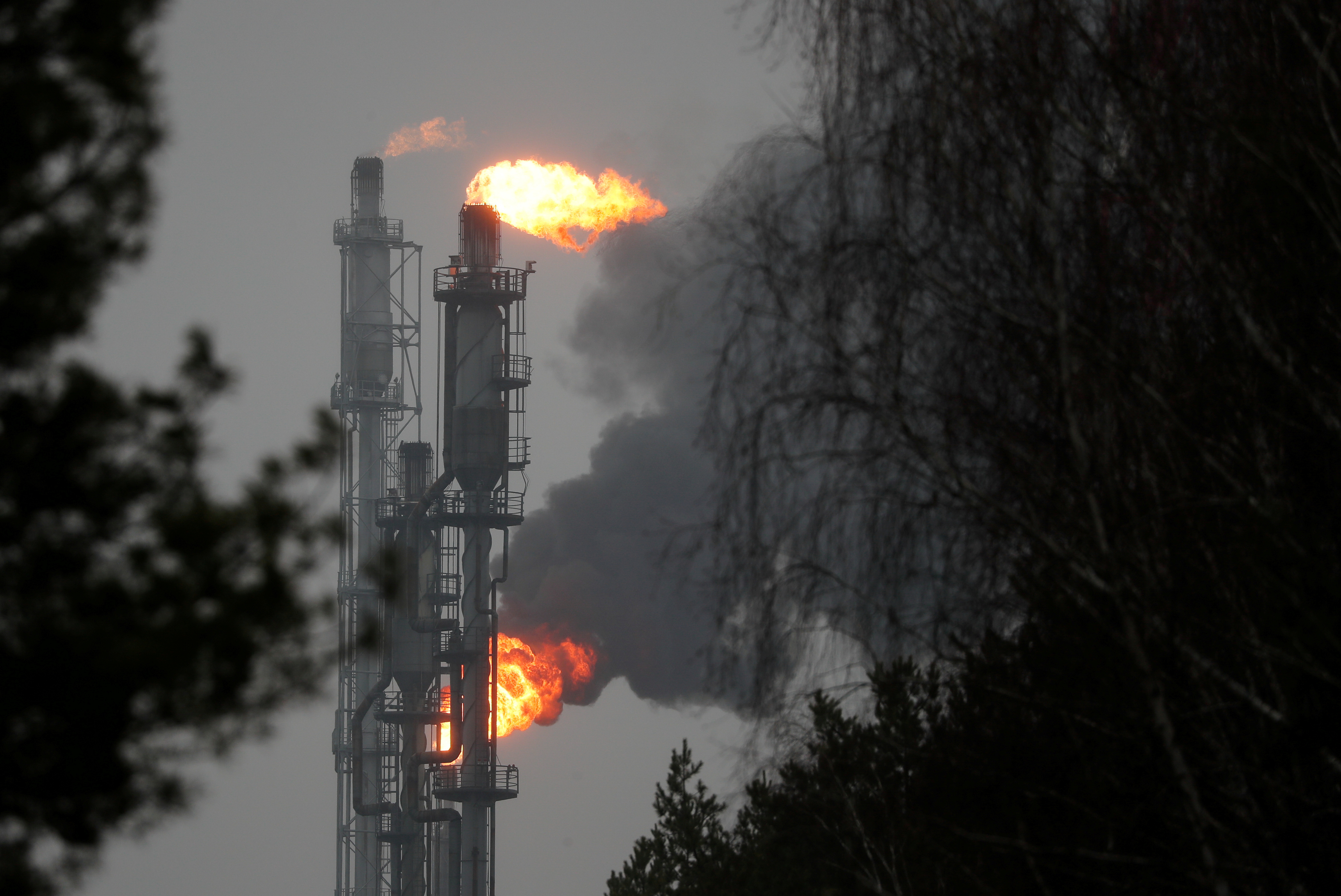
Denmark, Costa Rica seek alliance to speed up the end of oil and gas
By Kate Abnett and Stine Jacobsen August 25, 2021
A flame burning natural gas is seen at the Joint stock company “Mozyr oil refinery” near the town of Mozyr, Belarus January 4, 2020. REUTERS/Vasily Fedosenko/File Photo
BRUSSELS/COPENHAGEN, Aug 25 (Reuters) – Denmark and Costa Rica are trying to forge an alliance of countries willing to fix a date to phase out oil and gas production and to stop giving permits for new exploration, government ministers said and documents showed.
Burning fossil fuels is the main source of the greenhouse gas emissions heating the planet, but so far there has been no collective government action to end oil and gas production.
“Restricting domestic oil and gas production in line with what is required to live up to the Paris Agreement goals will be the core focus for BOGA,” a draft of the rules for the alliance said, referring to the group’s name – the Beyond Oil and Gas Alliance (BOGA).
Industry and governments are moving too slowly to meet the Paris Agreement’s goal of limiting temperature rises to 1.5 degrees Celsius (2.7° Fahrenheit), which scientists say requires the world to reach net zero emissions by 2050. read more
The International Energy Agency has said there should be no new investments in fossil fuel supply projects anywhere in the world if the Paris targets are to be met. read more
The draft document seen by Reuters said a core task for the BOGA would be to establish a deadline for developing and developed countries to phase out existing oil and gas production that would align them with the Paris goals.
To become a full member of the alliance, countries must promise to end new licensing rounds for oil and gas production on their territories, as well as to phase out existing production, the draft said. The draft could change before the expected launch of the BOGA at the U.N. climate summit in November in Glasgow, Scotland.
Countries could become second-tier members if they have taken some steps to limit oil and gas output, such as ending public financing of it abroad or reforming fossil fuel subsidies.
LEVEL OF SUPPORT UNCLEAR
Danish climate and energy minister Dan Jorgensen told Reuters Denmark, which is co-leading the initiative with Costa Rica, was talking to many countries, but it was too early to say how many would join the alliance.
One of the largest European oil and gas producers, Denmark last year banned new North Sea oil and gas exploration and committed to ending its existing production by 2050.
“Very few countries have taken such steps and we hope that this alliance will be something that will be noticed and hopefully inspire others to join,” Jorgensen said.
Costa Rica has never extracted oil, but is considering a bill to permanently ban fossil fuel exploration to ensure no future governments do so.
“Costa Rica represents the commitment and decision of a developing country that has the possibility to explore, makes a brave decision and decides to go for another development model and rides into the economy of the future,” Costa Rica’s environment minister Andrea Meza said.
New Zealand, which banned new permits for offshore oil in 2018, told Reuters it had been approached by Denmark and was “in the process of learning more about this initiative”.
Costa Rica’s Meza said the countries the alliance had approached included Portugal and Spain. Spain did not respond to Reuters’ requests for comment, while Portugal said it had not applied for membership of the alliance yet.
The United Kingdom, which is hosting the U.N. climate summit December and has not committed to phase out its oil and gas production or halt exploration, declined to comment on its involvement.
A UK government source, speaking on condition of anonymity, told Reuters the government is engaging with Denmark on the alliance.
However, some large producers – including Norway, western Europe’s top oil and gas producer, are not yet involved.
“We’ve not been contacted in this regard,” Norwegian deputy energy minister Tony Tiller told Reuters.
PARADOXIAL SITUATION
As a coalition of the willing, BOGA is unlikely to touch major oil and gas producers, such as Saudia Arabia or Russia, whose economies depend on fossil fuels, and which have shown no interest in curbing production.
But part of BOGA’s aim is to redefine what counts as climate leadership from governments. Large countries’ climate change targets tend to focus on reducing emissions from burning fossil fuels, but rarely limit the production of the fuels themselves.
“We are in a paradoxical situation right now where many countries have pledged to become carbon neutral but are actually still planning to produce oil and gas after that date,” Jorgensen said.
The United States, the world’s largest producer of both oil and gas, this year pledged to halve its emissions by 2030, from 2005 levels. The U.S. government did not respond to a request for comment on whether it is involved in BOGA.
Of the few countries that have taken action to ban fossil fuel exploration and production, France has committed to do so by 2040, and Spain by 2042.
Reports earlier this year had confirmed that 2020 was Europe’s warmest on record and one of the three hottest globally.
This new data shows that Europe’s temperature margin over previous years was significantly greater than previously thought.
Not only was the year 1.9C above the long-term average, it was more than 0.5C greater than the previous high mark.
“This level of difference to the previous long-term average, which is a large difference, is something that is concerning,” said Dr. Robert Dunn, a senior climate scientist at the UK Met Office.
“It is something to sit up and take notice of, but it’s not just the temperatures that are increasing, the extreme events, the heat waves we’re seeing this year, and last year as well. We’re seeing these responses across the world.”
Other researchers agreed that the scale of the record-breaking heat in Europe was troubling.
“The amount by which the previous record has been exceeded should worry us all,” said Prof Gabi Hegerl, professor of climate system science at the University of Edinburgh, who was not involved with the study.
“European temperatures are well measured and can be tracked back to the beginning of industrialization and beyond, using documentary evidence and proxy records. This long-term context emphasizes how unusual this warmth is.”
River. The warmth across Europe brought huge temperature differences from the long-term average in some countries with Estonia, Finland and Latvia all recording anomalies of 2.4C.
Overall, Europe has seen its five warmest years on record all occur since 2014.
One other area of the world experiencing rapid warming is the Arctic.
Temperatures over land reached worrying new heights, getting to 2.1C above the 1981-2010 average. This was the highest since the series of records began 121 years ago.
It was also the seventh year in succession with an annual average temperature more than 1C above the average.
“The Arctic, we see warming incredibly rapidly. It was the warmest average surface temperature in the Arctic in a series going back 121 years, in 2020,” said Dr Dunn.
“That, of course feeds down into places nearby, which includes Europe to some level. But we’re seeing these effects throughout the world.”
Key findings from the State of the Climate 2020
Earth’s greenhouse gases were the highest on record. Despite the global pandemic that slowed economic activity, the major atmospheric greenhouse gas concentrations including carbon dioxide (CO2), methane and nitrous oxide rose to a new record high in 2020.
CO2 levels were the highest in both the modern 62-year record and in ice cores dating back as far as 800,000 years.
Global sea level was the highest on record. For the ninth consecutive year, global average sea level rose to a new record high and was about 91.3mm higher than when satellite observations began.
Earth’s warming trend continued. The year 2020 was among the three-warmest years since records began (around 1850) and was the warmest year on record without an El Niño event (a warming climate pattern in the Pacific).
The last seven years (2014-20) were the seven warmest years on record.
While rainfall around the world wasn’t exceptionally high during 2020, the authors say that there’s a clear response from the hydrological cycle to sustained heating.
Total atmospheric water vapor was well above average. The extra moisture adds to the impact of higher temperatures on humans.
Dry conditions were seen in many parts of Europe in 2020
Taken together, the indicators show what one of the study’s editors calls “our new normal”.
“This report follows closely on the latest [UN] IPCC [climate] report which could not be clearer in its messaging,” said Dr. Kate Willett, from the Met Office.
“Our climate has changed and is likely to continue changing unless the key driver, greenhouse gases, are curbed, and what we’re seeing now is already straining our society and our environment.”
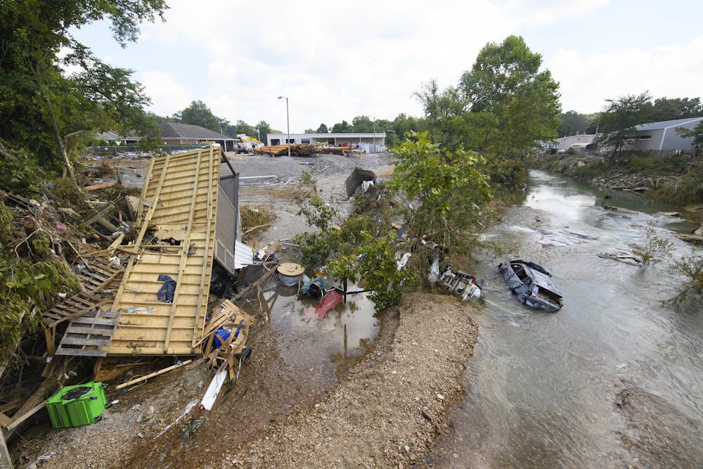
Extreme rainfall and flooding left paths of destruction through communities around the world this summer. The latest was in Tennessee, where preliminary data shows a record-shattering 17 inches of rain fell in 24 hours, turning creeks into rivers that flooded hundreds of homes and killed at least 18 people.
A lot of people are asking: Was it climate change? Answering that question isn’t so simple.
A decade ago, scientists weren’t able to confidently connect any individual weather event to climate change, even though the broader climate change trends were clear. Today, attribution studies can show whether extreme events were affected by climate change and whether they can be explained by natural variability alone. With rapid advances from research and increasing computing power, extreme event attribution has become a burgeoning new branch of climate science.
The latest attribution study, released Aug. 23, 2021, looked at the rainfall from the European storm that killed more than 220 people when floods swept through Germany, Belgium, Luxembourg and the Netherlands in July 2021.
A team of climate scientists with the group World Weather Attribution analyzed the record-breaking storm, dubbed Bernd, focusing on two of the most severely affected areas. Their analysis found that human-induced climate change made a storm of that severity between 1.2 and 9 times more likely than it would have been in a world 1.2 degrees Celsius (2.1 F) cooler. The planet has warmed just over 1 C since the industrial era began.
An overturned trailer and flooded car were washed into a creek by flash flooding during heavy rainfall in Tennessee.
Similar studies haven’t yet been conducted on the Tennessee storm, but they likely will be.
So, how do scientists figure this out? As an atmospheric scientist, I have been involved in attribution studies. Here’s how the process works:
How do attribution studies work?
Attribution studies usually involve four steps.
The first step is to define the event’s magnitude and frequency based on observational data. For example, the July rainfall in Germany and Belgium broke records by large margins. The scientists determined that in today’s climate, a storm like that would occur on average every 400 years in the wider region.
The second step is to use computers to run climate models and compare those models’ results with observational data. To have confidence in a climate model’s results, the model needs to be able to realistically simulate such extreme events in the past and accurately represent the physical factors that help these events occur.
The third step is to define the baseline environment without climate change – essentially create a virtual world of Earth as it would be if no human activities had warmed the planet. Then run the same climate models again.
The differences between the second and third steps represent the impact of human-caused climate change. The last step is to quantify these differences in the magnitude and frequency of the extreme event, using statistical methods.
For instance, we analyzed how Hurricane Harvey in August 2017 and a unique weather pattern interacted with each other to produce the record-breaking rainstorm in Texas. Two attribution studies found that human-caused climate change increased the probability of such an event by roughly a factor of three, and increased Harvey’s rainfall by 15%.
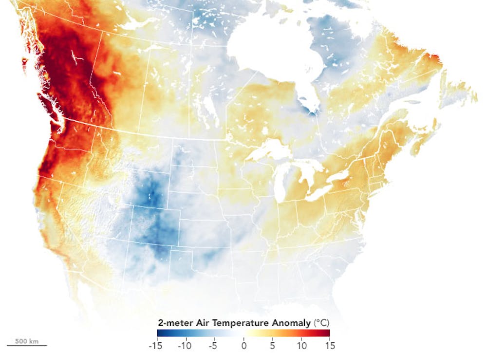
Another study determined that the western North American extreme heat in late June 2021 would have been virtually impossible without human-caused climate change.
US Map showing strong temperature anomalies from Oregon through British Columbia.
How good are attribution studies?
The accuracy of attribution studies is affected by uncertainties associated with each of the above four steps.
Some types of events lend themselves to attribution studies better than others. For instance, among long-term measurements, temperature data is most reliable. We understand how human-caused climate change affects heat waves better than other extreme events. Climate models are also usually skillful in simulating heat waves.
Even for heat waves, the impact of human-caused climate change on the magnitude and frequency could be quite different, such as the case of the extraordinary heat wave across western Russia in 2010. Climate change was found to have had minimal impact on the magnitude but substantial impact on the frequency.
There can also be legitimate differences in the methods underpinning different attribution studies.
However, people can make decisions for the future without knowing everything with certainty. Even when planning a backyard barbecue, one does not have to have all the weather information.
Xubin Zeng receives funding from NASA, DOE, NOAA, the US Army Corps of Engineers and the California Department of Water Resources. He is a fellow of both the American Meteorological Society and the American Association for the Advancement of Science, and is a member of the American Geophysical Union.