Forest Service officials confirm all California national forests to temporarily close
Gregory Yee
Heavy smoke from the Caldor fire hangs over Highway 50 near South Lake Tahoe last week. (Jason Armond / Los Angeles Times)
All of California’s national forests will be closed beginning late Tuesday.
The closures will go into effect at 11:59 p.m. Tuesday and stay in place until the same time on Sept. 17, according to an announcement by the U.S. Department of Agriculture Forest Service’s Pacific Southwest Region.
“We do not take this decision lightly, but this is the best choice for public safety,” said Regional Forester Jennifer Eberlien. “It is especially hard with the approaching Labor Day weekend, when so many people enjoy our national forests.”
The order doesn’t affect the Humboldt-Toiyabe National Forest, which is not in the Pacific Southwest Region, officials said.
Officials said they hope to reduce the number of people visiting national forests to prevent anyone from being trapped during an emergency such as a wildfire.
Having fewer people on national forest lands also decreases the likelihood of new fires starting and will help keep firefighters and the community safer by limiting possible COVID-19 exposure, officials said.
While California has seen massive wildfires, forestry officials said they worry about the “record level” conditions for fires and dry fuels, fires behaving “beyond the norm” of experience, “significantly limited” resources to fight fires, and no predicted relief from weather conditions into the late fall, according to Monday’s announcement.
“More than 6,800 wildfires have burned 1.7 million acres across all jurisdictions in California, and the National Wildfire Preparedness Level … has been at PL5 since July 14, 2021, only the third time in the past 20 years that the nation has reached PL5 by mid-July — indicating the highest level of wildland fire activity,” officials said.
Monday’s announcement comes weeks after the Forest Service closed nine national forests in Northern California.
Miami-Dade rejects coastal walls. It’s back to drawing board for hurricane protection.
Alex Harris
A proposal to protect coastal Miami-Dade from hurricanes by running a tall concrete wall though Biscayne Bay and waterfront neighborhoods is — unsurprisingly — dead.
The county on Monday formally rejected the plan, part of an instantly controversial $4.6 billion proposal from the Army Corps of Engineers that also included elevating thousands of private homes, flood-proofing thousands of businesses, planting mangroves and installing flood gates at the mouths of rivers and canals. Instead, the county will work with the Corps to come up with a new plan over the next year or so.
While the public and political leaders liked many of the Corps’ original ideas to address the rising risks of storm surge, there was little support for the walls.
In a March meeting with the village of Miami Shores, where the latest proposal called for an eight-foot wall along the east side of Biscayne Boulevard, which would have left hundreds of homes unprotected, the entire council came out against the walls.
“I haven’t heard anything but panicked cries for help about this, not even the slightest bit of support,” said then-councilman Sean Brady. “People are more interested in natural solutions or things that allow us to live with the flooding.”
Members of Miami’s Downtown Development Agency worried the up-to-20-foot walls would destroy property values and drive away investment in the wealthy downtown and Brickell neighborhoods. The agency even commissioned renderings of the wall — complete with graffiti and trash floating in the murky brown water — to drive home their point.
Other advocates for climate action in the community called the plan “a $5 billion Band-Aid” because the wall is only designed to protect against storm surge, not sea level rise. Other parts of the plan, like elevating and flood-proofing properties, serve double duty.
In February, politicians in Miami-Dade and Miami offered the Corps another, more politically palatable vision for coastal protection: a mangrove-covered and oyster bed-ringed island surrounding the coast, paired with shorter concrete walls on the mainland.
The concept, conceived and paid for by major Miami developer Swire Properties, did not go into the same detail as the Corps’ three-year, $3 million study. It also didn’t offer estimates on how much the alternate would cost or how high the walls would be.
For the last six months, Miami and Miami-Dade officials have worked to convince the Army Corps that this alternate vision was viable and worth paying for completely, but they were unable to reach an agreement with the wording of the original plan.
In a statement, Miami-Dade Mayor Daniella Levine Cava said Monday the county has “listened closely” to resident concerns throughout the process.
“Based on the feedback of residents and stakeholders, we are moving forward with our storm resilience efforts through a ‘Locally Preferred Plan’ to focus our readiness strategy on nature-based features and to continue working directly with impacted residents and cities,” she said.
As part of that, the county formally requested the Corps extend the study and add extra federal funding so Miami-Dade can work out a new plan.
Jim Murley, the county’s chief resiliency officer, said this extension will allow the county to get more input from the community and help find a solution that “strikes the right balance between protection from storm surge and that quality of life that we want in our community.”
“It’s a tough one to strike when there’s not much to look at for examples,” he said.
City of Miami Commissioner Ken Russell, who represents the majority of Miami’s bay front, said he supported the mayor’s decision to seek a locally preferred plan and pointed to the state of New Orleans’ levee system after Hurricane Ida a lesson for Miami.
While a concrete wall around our city is not a viable option, significant storm surge infrastructure in Miami is a must,” he said. “We cannot afford to simply reject the wall and send them away.”
Niklas Hallberg, project manager for the Back Bay study and Army Corps engineer, said his team will work with the county to figure out how much money and time they need to study a different solution. Once they submit it, he said, it usually takes about six to eight months for the Assistant Secretary of the Army for Civil Works in Washington to approve the request and then however long the engineers need to come up with a new strategy.
The extension will kick off another round of public comment, official meetings and more chances to review drafts of the plan.
This delay will likely cause the county to miss the next federal appropriation bill in 2022 that would get the ball rolling on design and development. The next available bill for this kind of project will be in 2024, which Halberg called “a reasonable goal.”
Halberg said it’s up to the county to ask for what kind of solution it wants the Corps to model. It does have to meet some critical federal standards, like passing a cost-benefit analysis that shows a project will prevent more property damage and losses than it costs to build.
“As far as what the county can do, they can tell us to remove the structures or they can request a much smaller plan,” he said. “The trade-off could be that there’s a lot more residual risk with that.”
Halberg said he believes the final version of the plan will include some type of structural element, but that it’s too soon to know for sure.
Under Corps rules, the federal government picks up 65% of the tab for any project approved by both the Corps and the local sponsor, in this case, Miami-Dade. Anything the county asks for in addition to the agreed-upon plan (like landscaping along the walls, or park benches) would be considered a “betterment” and fall on Miami-Dade to pay for.
“The Corps looks forward to continuing the relationship with the county on a locally preferred plan and getting a solution that everyone can be pleased with and get the storm protection Miami needs,” Halberg said.
There was a report of one fatality in Prairieville after a victim was apparently struck by a falling tree, the Ascension Parish Sheriff’s Office said.
A man passes by a section of roof that was blown off of a building in the French Quarter by Hurricane Ida winds on Aug. 29, 2021, in New Orleans. (Eric Gay / AP)
Jefferson Parish President Cynthia Lee Sheng told reporters earlier Sunday that the only road into Grand Isle, a barrier island south of New Orleans that is home to less 1,000 people, was under six feet of water. The local fire station was flooded, she said, and a few dozen people appeared to have disregarded a mandatory evacuation order.
“The conditions are very, very bad,” she said. “They are really getting beaten up right now.”
Images posted on Facebook by someone who appeared to be riding out the storm in Grand Isle showed roads topped with white-capped waves and a parking lot submerged in water.
“Pray for us all,” the person wrote.
The National Hurricane Center described Ida’s storm surge as “catastrophic” and said it could measure as much as 16 feet at Port Fourchon, where it made landfall shortly before noon.
Elsewhere in southern Louisiana, the quick rise in sea level was expected to be less, the center said. But security camera video from a fire station in St. Bernard Parish, east of New Orleans, showed what was still a dramatic surge of water.
The storm made landfall with maximum sustained winds of 150 mph, and video and photos from areas in and around New Orleans showed roofs that had been ripped from buildings and, in one case, tossed down the road into a power line.
In Galliano, southwest of New Orleans, top sections of the Lady of the Sea Hospital could also be seen getting hurled from the building.
In St. Rose, just west of downtown New Orleans, a boat collision was captured on camera. A barge crashed into a bridge in Jefferson Parish, making it structurally unsafe, officials there said. It was one of more than a dozen examples in the region of what a spokesman with the U.S. Coast Guard’s local office described as “breakaway barges.”
In one instance, the regional transit authority told the station that the vessel had detached from a barge and run aground.
In St. Bernard Parish, where the Chalmette ferry could be seen floating upriver, parish president Guy McInnis told the station: “Nothing we can do at this point.”
A New Breed of Crisis: War and Warming Collide in Afghanistan
Somini Sengupta
Somalian refugees displaced by drought wait for rations in Dadaab, Kenya, July 14, 2011. (Tyler Hicks/The New York Times)
Parts of Afghanistan have warmed twice as much as the global average. Spring rains have declined, most worryingly in some of the country’s most important farmland. Droughts are more frequent in vast swaths of the country, including a punishing dry spell now in the north and west, the second in three years.
Afghanistan embodies a new breed of international crisis, where the hazards of war collide with the hazards of climate change, creating a nightmarish feedback loop that punishes some of the world’s most vulnerable people and destroys their countries’ ability to cope.
And although it would be facile to attribute the conflict in Afghanistan to climate change, the impacts of warming act as what military analysts call threat multipliers, amplifying conflicts over water, putting people out of work in a nation whose people largely live off agriculture, while the conflict itself consumes attention and resources.
“The war has exacerbated climate change impacts. For 10 years, over 50% of the national budget goes to the war,” said Noor Ahmad Akhundzadah, a professor of hydrology at Kabul University, said by phone Thursday. “Now there is no government, and the future is unclear. Our current situation today is completely hopeless.”
A third of all Afghans face what the United Nations calls crisis levels of food insecurity. Because of the fighting, many people haven’t been able to plant their crops in time. Because of the drought, the harvest this year is certain to be poor. The World Food Program says 40% of crops are lost, the price of wheat has gone up by 25%, and the aid agency’s own food stock is due to run out by the end of September.
Afghanistan is not the only country to face such compounding misery. Of the world’s 25 nations most vulnerable to climate change, more than a dozen are impacted by conflict or civil unrest, according to an index developed by the University of Notre Dame.
In Somalia, pummeled by decades of conflict, there has been a threefold increase in extreme weather events since 1990, compared with the previous 20-year period, making it all but impossible for ordinary people to recover after each shock. In 2020, more than 1 million Somalis were displaced from their homes, about a third because of drought, according to the United Nations.
In Syria, a prolonged drought, made more likely by human-made climate change, according to researchers, drove people out of the countryside and fed simmering anti-government grievances that led to an uprising in 2011 and, ultimately, a full-blown civil war. This year again, drought looms over Syria, particularly its breadbasket region, the northeastern Hassakeh province.
In Mali, a violent insurgency has made it harder for farmers and herders to deal with a succession of droughts and flood, according to aid agencies.
Climate change cannot be blamed for any single war, and certainly not the one in Afghanistan. But rising temperatures, and the weather shocks that come with it, act as what Marshall Burke, a Stanford University professor, calls “a finger on the scale that makes underlying conflict worse.” That is particularly true, he argued, in places that have undergone a long conflict and where government institutions have all but dissolved.
“None of this means that climate is the only or the most important factor in conflict,” said Burke, co-author of a 2013 paper looking at the role of climate change in dozens of conflicts across many years. “But based on this evidence, the international community would be foolish to ignore the threat that a warming climate represents.”
The combination of war and warming compounds the risks facing some of the world’s most vulnerable people: According to the U.N. children’s agency, Afghanistan is the 15th-riskiest country in the world for children, because of climate hazards, including heat and drought, and a lack of essential services, including health care. Two million Afghan children are malnourished.
That is in sharp contrast to Afghanistan’s part in global warming. An average Afghan produces 0.2 metric tons of carbon dioxide emissions per year, compared with nearly 16 metric tons of the average American.
The collapse of the government has also made Afghanistan’s participation in the next international climate talks entirely uncertain, said one of its members, Ahmad Samim Hoshmand. “Now I don’t know. I’m not part of any government. What government I should represent?” he said.
Until recently, he had been the government official in charge of enforcing the country’s ban on ozone-depleting substances, including refrigerants used in old air-conditioners and that are banned by the Montreal Protocol, an international agreement that Afghanistan had ratified. Just days before the Taliban seized Kabul, he fled to Tajikistan. The traders of illegal substances whom he helped arrest are now out of prison, keen to exact revenge. He says they will kill him if he returns.
Hoshmand is now scrambling to emigrate elsewhere. His visa in Tajikistan expires in a matter of weeks. “My only hope is the ozone community, the Montreal Protocol community, if they can support me,” he said.
Afghanistan’s geography is a study of extreme hazard, from the glacier-peaked Hindu Kush mountains in the north to its melon farms in the west to the arid south, stung by dust storms.
Climate data is sparse for Afghanistan. But a recent analysis based on what little data exists suggests that a decline in spring rains has already afflicted much of the country, but most acutely in the country’s north, where farmers and herders rely almost entirely on the rains to grow crops and water their flocks.
Over the past 60 years, average temperatures have risen sharply, by 1.8 degrees Celsius since 1950 in the country as a whole and by more than 2 degrees Celsius in the south.
“Climate change will make it extremely challenging to maintain — let alone increase — any economic and development gains achieved so far in Afghanistan,” the United Nations warned in a 2016 report. “Increasingly frequent and severe droughts and floods, accelerated desertification, and decreasing water flows in the country’s glacier-dependent rivers will all directly affect rural livelihoods — and therefore the national economy and the country’s ability to feed itself.”
This is the country’s biggest risk, Akhundzadah argued. Three-fourths of his compatriots work in agriculture, and any unpredictable weather can be calamitous, all the more so in a country where there hasn’t been a stable government and no safety net to speak of.
The Taliban, for their part, appear more exercised by the need to scrub women’s pictures from billboards than addressing climate hazards.
But climate change is a threat multiplier for the Taliban, too. Analysts say water management will be critical to its legitimacy with Afghan citizens, and it is likely to be one of the most important issues in the Taliban’s relations with its neighbors as well.
Already on the Afghan battlefield, as in many battlefields throughout history, water has been an important currency. The Taliban, in their bid for Herat, a strategic city in the west, repeatedly attacked a dam that is critical for drinking water, agriculture and electricity for the people of the region. Likewise, in Kandahar province in the south, one of the Taliban’s most critical victories was to seize control of a dam that holds water for drinking and irrigation.
Climate change also stands to complicate the Taliban’s ability to fulfill a key promise: the elimination of opium poppy cultivation. Poppies require far less water than, say, wheat or melons, and they are far more profitable. Poppy farming employs an estimated 120,000 Afghans and brings in an estimated $300 million to $400 million a year, according to the United Nations, and has, in turn, enriched the Taliban.
Areas under poppy cultivation grew sharply in 2020.
Analysts said the Taliban would seek to use a poppy ban to gain legitimacy from foreign powers, such as Qatar and China. But it is likely to face pushback from growers who have few alternatives as the rains become less reliable.
“It’s going to be a gigantic political flashpoint,” said Vanda Felbab-Brown, who studies the region at the Brookings Institution in Washington, D.C.
The last drought, in 2018, left 4 million Afghans in need of food aid and forced 371,000 people to leave their homes, many of whom haven’t returned.
“The effects of the severe drought are compounded by conflict and the COVID-19 pandemic in a context where half the population were already in need of aid,” U.N. humanitarian coordinator Ramiz Alakbarov said by email from Kabul on Thursday. “With little financial reserves, people are forced to resort to child labor, child marriage, risky irregular migration exposing them to trafficking and other protection risks. Many are taking on catastrophic levels of debt and selling their assets.”
Akhundzadah, a father of four, is hoping to emigrate, too. But like his fellow academics, he said he has not worked for foreign governments and has no way to be evacuated from the country. The university is closed. Banks are closed. He is looking for research jobs abroad. For now, there are no commercial flights out of the country.
“Till now, I’m OK,” he said on the phone. “The future is unclear. It will be difficult to live here.”
COVID and wildfires gave us an education instead of a vacation. We’ll never be the same.
Jill Lawrence, USA TODAY
Smoke from the Caldor Fire in California covers Lake Tahoe in the Incline, Nev., area on Aug. 24, 2021.
The last time we tried for a two-week vacation, in 1993, a Hurricane Emily evacuation forced us to leave after six days. Nearly three decades later, we decided to try again. We left early this time, too, after close encounters with COVID-19 and wildfires.
This is not a first-world rant against the inconvenience of climate change and a virus we can’t seem to beat. Rather, it’s a look at lessons learned and not learned – about the folly of betting against nature, science and, in particular, the frightening fires that seem remote on the East Coast but often dictate life in the West. It’s about the friction between a husband and wife with different tolerances for masking, crowds and indoor vs. outdoor dining, as they traveled through a patchwork of pandemic regulations in three states.
And it’s about a family that keeps trying against the odds to celebrate, together in person, two birthdays four days apart in August – prime hurricane and wildfire season and, in 2020 and 2021, prime COVID season as well.
Smoke and COVID on Day One
We should have known from the start that the trip was going to be problematic. The weather app on my phone showed a solid gray sky in Seattle, our first destination, and the forecast was “Smoke.” Those were firsts in my East Coast experience. Friends had arranged a dinner out on our first night. But the restaurant had a COVID outbreak and was closed all three nights we were there.
Our next adventure was a road trip down the Oregon coast, staying in five towns over five nights. We were in Cannon Beach four days after Gov. Kate Brown reinstated a mask mandate for indoor gatherings. There were posters on store doors all over town announcing the mandate. And, in what could be interpreted as simple fact or passive aggression, they offered Brown’s office number and told people with questions to call her.
“Any questions please call Oregon Governor Kate Brown’s office”: Mask mandate signs on store doors in Bandon, Ore., on Aug. 18, 2021.
Each town brought new reasons to study COVID responses. In Newport, a motel clerk was behind plastic but not masked (fine with me, but not my husband). In Fortuna, motel clerks were masked and so was our waiter at a brewery where we ate outdoors. The inevitable happened at a Bandon bakery, as we waited with a dozen others to order or pick up breakfast: An unmasked young man walked in, an employee offered him a mask, he looked annoyed and he stalked back out the door.
Our first stop in California was Crescent City in Del Norte County, the hottest COVID hotspot on the West Coast. We picked a table far from other diners in a large airy restaurant, and my husband noted to our waiter that he was unmasked. The adorable teenager offered to wear one, but he also reminded us of what we had forgotten: We were no longer in Oregon, so there was no mandate.
Halfway through our meal, we heard an older server tell our waiter that a party of 14 was expected in 15 minutes. Unnerved by the prospect of 14 unmasked strangers at tables the staff was pushing together right next to ours, we gulped a few last bites, paid up and fled.
A second try for Lake Tahoe
Lake Tahoe has been on my bucket list for years, thanks to raves from friends and family. Last year we rented a house there, but COVID forced us to cancel. This year we rented the same house and crossed our fingers. But as we started a 6.5-hour drive, the fire danger snapped into focus. We saw smoke haze for most of the trip. In the parking lot of a Tahoe City supermarket, we slapped on our COVID masks to filter out the smoky air. At the rental house, two big cinders flew by my face as I stepped onto the driveway. Welcome to Tahoe.
Sun through smoke at 11 a.m. PT in Tahoe City, Calif., on Aug. 23, 2021.
I immediately started following @CAL_FIRE on Twitter and checking several times a day on the Caldor Fire, which had destroyed nearly 500 homes and commercial buildings: 98,000 acres and 0% contained. 106,000 and 5% contained. The air quality was hazardous. Then very unhealthy. Then back to hazardous. We had lists of best walks, hikes and places to see sunsets, but we couldn’t go outside. Government agencies advised everyone to stay inside and limit activities. The haze was so thick that there was nothing to see, anyway.
The saving grace was that our sons were coming. One of them was flying into Reno, Nevada, on Aug. 23, the day before his birthday. But wildfire smoke diverted the flight to San Francisco, and then it was canceled. He returned home to Los Angeles the same night. His older brother, driving from Salt Lake City, had been waiting in Reno to pick him up. He continued on to Tahoe alone.
Lake Tahoe’s Emerald Bay is shrouded in smoke from the Caldor Fire, near South Lake Tahoe, Calif., on Aug. 24, 2021.
When the Tahoe air improved to simply “unhealthy,” my first reaction was wow, that’s great. My second was, it’s actually not great when “unhealthy” seems great. “I don’t think it’s healthy to be here,” I told my husband late Monday night. We ended up leaving two days early, on Wednesday. Our Reno-Denver flight was canceled early that morning for visibility reasons, but the airline rebooked us. We walked in our front door in Washington, D.C., about 2 a.m.
Our decision was prescient. By last Tuesday, as it advanced toward Tahoe and closed Reno schools, the Caldor Fire was the No. 1 priority for national firefighting resources. On Wednesday, as we drove away, Tahoe City and South Lake Tahoe had the worst air pollution in the nation. By Thursday, Tahoe basin evacuations had started and tourists were being asked to stay home. By Friday, the fire had grown to 225 square miles and weather conditions were getting worse. On Saturday, a fire that began 70 miles from Lake Tahoe on Aug. 14 was about 8 miles away.
John Martin and Jill Lawrence at Redwood National Park in northern California on Aug. 21, 2021.
This was not quite the trip we had planned. We did reunite with friends in Seattle, and the Oregon coast did live up to its spectacular billing, as did the redwoods. As far as I know, we avoided catching plague from chipmunks at Lake Tahoe. And so far, we are coronavirus-free. But our Pacific Northwest sojourn was not so much an escape as an immersion in two clear and present dangers: COVID and climate change.
The active life we’ve avoided for so long at home exposed us to more COVID risk on the road and more diverse views on how and whether to reduce risk. The challenges of figuring out appropriate restrictions and precautions were never more clear. As for climate change, as an East Coast lifer, I am familiar with its role in making hurricanes more destructive, but until now I could only imagine its impact in the increasingly dry and hot West. This firsthand experience with drought and fire made the climate crisis real and urgent, and our strange, sobering “vacation” unforgettable.
‘Our future might not look the same’: wildfires threaten way of life in California’s mountain towns
Dani Anguiano in Concow
Photograph: Eugene García/AP
Megan Brown’s family has stewarded several ranches in and along California’s northern Sierra Nevada for six generations.
But in the last four years, the Browns have faced unprecedented challenges. Four different wildfires have touched the family’s ranches in Oroville and Indian Valley. Smoke has killed some of their animals. Years of drought have ravaged their lands.
The disasters have threatened the family’s livelihood, and forced them to question whether life in this region can continue as it has as the climate crisis intensifies.
“If I want our family to continue this lifestyle, it might not look the same as it always has,” said Brown. “Trying to come to terms with that is really hard. I feel like I have to grieve and I don’t know what the future’s going to look like. I don’t know what I should be doing.”
Deadly fires have battered this part of northern California almost annually since 2018, destroying entire communities, killing dozens and covering the area in smoke for weeks at a time.
This year, the region is threatened by the Dixie fire, California’s largest ever single wildfire, and the biggest blaze currently burning in the United States. The fire has already scorched more than 750,000 acres, burning across the mountain range and destroying much of the small hamlet of Greenville.
“I should have been a firefighter instead of a cowboy,” said Brown on a recent afternoon as she glanced down at her phone for updates on the fire, which was raging around one of the ranches.
The fire risk in this part of California goes hand in hand with its abundance of natural beauty: river canyons with emerald green water, rolling foothills of the Sierra Nevada that grow thick in the spring with wildflowers, and vast swaths of trees. In some areas, such as the remote settlement of Concow, Ponderosa pines and Douglas firs cover the landscape – their branches sometimes arch over the roads like a canopy.
This stretch of land, from the Feather River in Oroville up to Lake Almanor, is particularly conducive to flames thanks in part to its steep canyons and seasonal winds. Severe drought has only exacerbated the fire risk.
There is no indication that these extreme wildfires will diminish in the coming years without dramatic steps to reintroduce fire into the landscape to reduce fuels in the forest and tackle the climate emergency.
“California is going to fundamentally change,” said Marshall Burke, an associate professor in the department of earth system science at Stanford. “All evidence would suggest a business as usual scenario where we keep warming the climate and we don’t rapidly scale up our efforts to get fuels out of the forest we’re going to see a lot more wildfire and a lot more extreme wildfire. The science is clear on that.”
Sierra Nevada communities, like the town of Greenville that burned earlier this month, were already struggling with population decline, largely due to economic issues, said Jesse Keenan, a climate adaptation expert at Tulane University. The climate crisis will probably accelerate that decline.
Insurers have become reluctant to cover homes and businesses in the region, raising questions about the ability to rebuild. Kimberly Price, a Greenville resident, said she lost insurance coverage for her home because she was in a fire zone, and her partner lost coverage on his store, which burned down in the Dixie fire, for the same reason.
“This is a problem in the state of California. If you can’t get your house insured, people aren’t going to move here,” she said.
Intensifying wildfires also means the region will continue to see severe smoke lingering for weeks at a time, including in more densely populated cities such as Chico and Oroville. This week, air quality in the Lake Tahoe region ranked among the worst in the world because of smoke from the Caldor fire.
Smoke at the levels seen this year and last year are likely to be normal going forward, Burke said. “Instead of a few days or a week or two of smoke exposure it’s going to look more like 2020 and 2021 where we have months of bad air,” he said. “The science suggests 2020 is a historical anomaly looking backwards but looking forward it’s not going to be.”
That is particularly bad for vulnerable populations such as elderly people and those suffering from pre-existing health conditions, but the effects extend far beyond. A recent study from Stanford University, of which Burke is an author, found breathing wildfire smoke during pregnancy increases the risk of premature birth. Research also shows an increase in the rate of heart attacks, increased susceptibility to Covid-19 and decreased test scores among children exposed to smoke.
Wildfire smoke has killed several of Brown’s animals in recent years, she said, and there’s nothing she can do to protect them. “They all sound like they’re pack-a-day smokers. And it’s like, are they sick? No, they’ve been out in the smoke for a month.”
At the same time, the drought brought a swarm of grasshoppers to the land and forced Brown to reduce her herd. “Our cattle herd is decimated. Our ranches are on fire. I don’t have water.”
One of the keys to combating the state’s deadly megafires involves restoring fire’s role in the landscape with prescribed burns, said Don Hankins, a pyrogeographer and Plains Miwok fire expert at California State University, Chico. Prescribed burns help clear fire-fueling vegetation, and can prevent larger, more extreme blazes.
“If people were able to practice the way indigenous cultures have done so since the beginning of time, that would be the way to change the way fires move with the landscape,” he said. Prescribed burning creates less smoke than the megafires California is seeing today, Hankins said, and gives people a say in when and how smoke is dealt with.
Rather than abandoning these areas, people must learn to change the way they live with fire, Hankins said.
“There is no no-fire solution,” he said. “Fire has to be part of this landscape. It has to be, so we should be the ones directing it.”
To Concow residents Pete and Peggy Moak, prescribed burns are an important tool to live in a remote part of California prone to burning. The couple has survived several wildfires, each time staying behind in their home to battle the encroaching flames.
Their expansive property is pristinely manicured and watered – Pete, a former logger, manages the trees – with a large vegetable garden, a fire break and paths free of debris and vegetation so that if a fire does burn they can defend their home. This time of year, the risk is ever present.
“We’ve got a lot of PTSD,” said Pete, whose family has lived in the area since the 19th century. “It’s unexplainable how the tension is, but there’s never a dull moment.”
Jennifer Whitmore sprays her home with water as the Caldor fire burns near White Hall, California, on 17 August.Photograph: Ethan Swope/AP
Fire will surely scorch this area again, the couple says, and living here requires constantly maintaining their land and the lots around them by felling dead trees, clearing needles and dead leaves and using prescribed burns. It also means they’ve all but stopped traveling in the summer and fall, so that they are here to save their home if necessary.
“It’s hard to understand for folks that live in town and sell their house every five years and move somewhere else,” Pete said.
“Pete and folks like us, we have deep roots in the land,” Peggy said.
Brown, too, can’t see herself leaving the land her family has tended for decades or the animals she loves. “That ranch, this land is my passion and I will die defending it. I’ve been here too long. I love it too much,” she said.
But she wonders whether local elected officials will take the necessary steps to prevent these sorts of devastating fires and assist those affected by them.
“Either we’re going to pull it together and we’re going to be better and more resilient and able to protect ourselves. Or we’re just going to be in this cycle of rebuilding and burning, rebuilding and burning,” she said.
Between hot weather and uneven moisture, tomato growing is tough. These tips may help
Dennis Patton
Ice cream, sweet corn and tomatoes are some of the best flavors of summer. More than any other vegetable, tomatoes have a wide variety of home remedies to grow the best-tasting fruit or produce higher yields. Some of these recommendations shared have validity, while others have no effect.
Midwest summer conditions make tomato harvest unpredictable. Heat and uneven moisture will decrease fruit set and quality. Managing weather patterns is a challenge, but here are some research-based tips to make sure you enjoy tasty tomatoes this summer and into fall.
Fluctuation of water
Uneven moisture slows plant growth, reducing flowering and fruit set. Tomatoes produce best when actively growing. Starting and stopping the growing process due to lack of water disrupts the plants’ ability to produce flowers.
When the fruits split or crack before harvesting, it is often a result of uneven moisture. An influx of water after stress results in the rapid growth of the fruit, causing the splits.
New hybrids are bred to be more crack resistant. Heirloom varieties tend to be prone to cracking because of their less firm skin and meat, which many people desire. Mulching around the plant to conserve moisture as well as timely watering are the recommendations.
Lack of fruit
Tomato plants set fruit best with nighttime temperatures in the 60s and daytime highs in the 80s. Temperatures like these are not as common in Kansas City.
Temperatures over 95 degrees, which frequently occur in our area during the summer, hinder pollination. Hot, windy days dry the pollen before it has time to fertilize the fruits. Tomatoes are wind pollinated, and drying winds kill the pollen, which lowers pollination.
Controlling weather patterns like these is not possible. The best recommendation is to continue to provide good care and even moisture. A healthy plant will recover more rapidly as the stressful periods come and go.
Slow to ripen
Temperatures in the 90s also affect fruit ripening. Tomatoes maturing under hot weather fail to develop the deep beautiful red color. Instead, tomatoes ripening under heat are more orange-red in color. The flavor is the same, just not the color.
Achieving red fruit in a hot summer can be accomplished by picking at the breaker stage. This stage occurs when the fruit has reached about half green, half pinkish-red in color.
At this point, the plant forms a layer of cells across the stem, stopping the movement of sugars, which creates the flavor. In other words, all the flavor compounds are inside the fruit at this point.
Pick the partially red tomato and ripen it indoors under home temperatures. Once fully ripe and deep red, the color is more appetizing and the flavor is the same.
Indoor ripening is controlled by temperature, not exposure to light or dark. The optimum ripening temperature is in the mid 80s.
Picking at the breaker stage may help protect the fruit from the neighborhood squirrels as well. They have a knack for getting the bounty a day or two before you.
Dennis Patton is a horticulture agent with Kansas State University Research and Extension. Have a question for him or other university extension experts? Email them to garden.help@jocogov.org.
As Colorado River Basin states confront water shortages, it’s time to focus on reducing demand
Robert Glennon, Regents Professor and Morris K. Udall Professor of Law & Public Policy, University of Arizona
Water flows into a canal that feeds farms in Casa Grande, Ariz.AP Photo/Darryl Webb
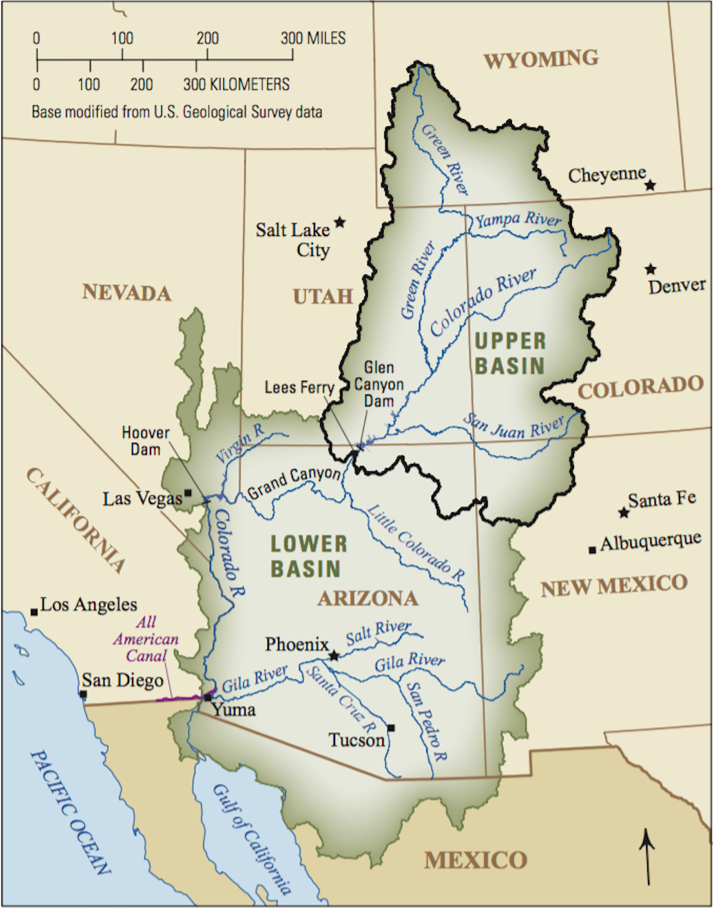
The U.S. government announced its first-ever water shortage declaration for the Colorado River on Aug. 16, 2021, triggering future cuts in the amount of water states will be allowed to draw from the river. The Tier 1 shortage declaration followed the U.S. Bureau of Reclamation’s forecast that the water in Lake Mead – the largest reservoir in the U.S., located on the Arizona-Nevada border – will drop below an elevation of 1,075 feet above sea level, leaving less than 40% of its capacity, by the end of 2021.
The declaration means that in January 2022 the agency will reduce water deliveries to the Lower Colorado River Basin states of Arizona and Nevada and to Mexico, but not to California – yet.
Map of Colorado River Basin.
Arizona will lose the most water: 512,000 acre-feet, nearly a fifth of its total Colorado River allocation of 2.8 million acre-feet. Nevada will lose 21,000 and Mexico 80,000. An acre-foot is enough water to cover an acre of land, which is roughly the area of a football field, to a depth of one foot – about 326,000 gallons.
Central Arizona farmers are the big losers in this first round of cuts. The cities are protected because they enjoy the highest priority in Arizona for water delivered through the Central Arizona Project, a 330-mile canal from the Colorado River. From my experience analyzing Western water policy, I expect that this declaration won’t halt growth in the affected states – but growth can no longer be uncontrolled. Increasing water supply is no longer a viable option, so states must turn to reducing demand.
Conservation remains the low-hanging fruit. Water reuse – treating wastewater and using it again, including for drinking – is also viable. A third option is using pricing and trading to encourage the reallocation of water from lower-value to higher-value uses.
Interstate collaboration
The Colorado River Basin states have formally negotiated who can use how much water from the Colorado River since they first inked the Colorado River Compact in 1922. In 2007 they negotiated interim shortage guidelines that specified how much each state would reduce its use depending on the elevation of Lake Mead. A series of subsequent agreements included Mexico, increased the scale of reductions and authorized the secretary of the Interior, ultimately, to impose truly draconian cuts.
California does not take a cut until the level in Lake Mead drops even lower. But that could happen as soon as 2023. The water level is dropping partly because of the Western drought but also because of the shape of Lake Mead, which was created by damming Boulder Canyon in 1936.
Like most Western river canyons, Boulder Canyon is wide at the rim and narrow at its base, like a martini glass. As its water elevation drops, each remaining foot in the lake holds less water.
Lake Mead feeds Hoover Dam, one of the largest hydroelectric generating facilities in the country. The plant produces electricity by moving water through turbines. When Lake Mead is high, Hoover Dam’s generating capacity is more than 2,000 megawatts, which produces enough electricity to supply some 450,000 average households in Nevada, Arizona and California.
But the plant has lost 25% of its capacity as Lake Mead has dropped. If the water level declines below about 950 feet, the dam won’t be able to generate power.
Sending water south
The Upper Basin states – Colorado, Wyoming, Utah and New Mexico – will also suffer.
That’s because the Colorado River Compact obligates the Bureau of Reclamation to release an annual average of 8.23 million acre-feet from Lake Powell, the nation’s second-largest reservoir, which extends from southern Utah into northern Arizona.
The Bureau of Reclamation predicted in mid-July that runoff into Lake Powell for 2021 will total just 3.23 million acre-feet, or 30% of average. To make up for this shortfall, the bureau will release more water from three Upper Basin reservoirs: Flaming Gorge in Utah, Blue Mesa in Colorado and Navajo on the Colorado-New Mexico border.
The ultimate problem facing the Colorado River Basin states is simple. There are more water rights on paper than there is water in the river. And that’s before considering the impact of climate change and evaporation loss from Lakes Mead and Powell.
The urgency of the Tier 1 shortage declaration has generated wild-eyed proposals to import water from far-flung places. In May 2021, the Arizona legislature passed a bipartisan resolution calling on Congress to study a pipeline from the Mississippi River that would augment the Colorado River. Space does not permit me to elaborate all the obstacles to this idea, but here’s a big one: the Rocky Mountains.
Similarly, the city of St. George in southwest Utah has proposed building a 140-mile pipeline from Lake Powell to augment its supply. St. George has some of the highest water consumption and lowest water prices in the country.
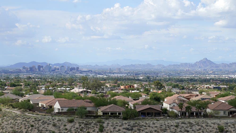
Downtown Phoenix with suburban homes in foreground.
The gospel of growth still motivates some cities. Buckeye, Arizona, on the west side of Phoenix, has a planning area of 642 square miles, which is larger than Phoenix. The city has approved 27 housing developments that officials project will increase its population by 800,000 people by 2040. Yet its water supply depends on unsustainable groundwater pumping.
Other communities have faced reality. In early 2021 Oakley, Utah, east of Salt Lake City, imposed a construction moratorium on new homes, sending shivers up the spines of developers across the West.
Enabling farmers to be more efficient
The Tier 1 declaration gives states and local communities reason to remove barriers to transferring water. Market forces are playing an increasingly critical role in water management in the West. Many new demands for water are coming from voluntary transfers between willing sellers and desperate buyers.
Water markets threaten rural communities because farmers cannot hope to compete with cities in a free market for water. Nor should they have to. Water remains a public resource. I believe the states need a process to ensure that transfers are consistent with the public interest – one that protects the long-term viability of rural communities.
As the West enters an era of water reallocation, most of the water will come from farmers, who consume more than 70% of the region’s water. Cities, developers and industry need only a tiny fraction of that amount for the indefinite future.
What if municipal and industrial interests created a fund to help farmers install more efficient irrigation systems instead of simply flooding fields, a low-tech approach that wastes a lot of water? If farmers could reduce their water consumption by 5%, that water would be available to cities and businesses. Farmers would continue to grow as much food as before, thus protecting the stability of rural communities. This could be a win-win solution to the West’s water crisis.
Many California farmers have water cut off, but a lucky few are immune to drought rules
Ari Plachta
Kim Gallagher in one of her rice fields in Knights Landing. (Max Whittaker / For The Times)
Driving between her northern Central Valley rice fields with the family dog in tow, fifth-generation farmer Kim Gallagher points out the window to shorebirds, egrets and avocets fluttering across a thousand-acre sea of green flooded in six inches of water.
“People say agriculture uses so much water, but if you knew who lived in these areas and if you saw the animals taking advantage of it, you’d think there’s a lot more going on here,” Gallagher said. “This is where you’re going to find a Great Blue Heron. If you don’t want that type of bird then we shouldn’t be growing rice.”
The nearly 500,000 acres of sushi rice grown in the Sacramento Valley each year serve as the wetland habitat for thousands of migrating birds along the Pacific Coast. Yet the crop also uses more water than most, and about half of the product is exported to countries including Japan and South Korea.
Since the 1920s, farmers have grown rice in the Sacramento Valley, where old hands fly crop duster planes and rice emblems mark the county buildings. Now, due to decades-old agreements with the federal government, rice farmers like Gallagher are going relatively unscathed by unprecedented emergency water cuts to farmers this month as others fallow fields, wells go dry and low water levels imperil Chinook salmon, the native cold-water fish that play critical ecological roles and support a billion-dollar fishing industry.
A handful of districts supplying farmers including Gallagher are receiving nearly 2 million acre feet of water this drought year, enough to supply the city of Los Angeles for roughly four years. Their seniority is a function of the state’s complicated water rights system, which some experts say is ripe for reform as extreme drought magnifies the inequities within it.
Developed in the 19th century by miners who used water to blast gold out of the Sierra foothills, California water rights are based on a concept known as “first in time, first in right.”
An irrigation canal that feeds rice fields in Knights Landing. (Max Whittaker / For The Times)
The principle, which remains central to state water law today, roughly translates to “first come, first served” to a quantity of water from a natural source. During drought, rights are curtailed by state regulators from newest to oldest to protect water for residential use and human health and safety essentials.
Most farmers across the state who rely on the Central Valley Project, the nearly two dozen dams and hundreds of canals that make up the federal water allocation system, are getting 5% or less of their usual water supply this year.
The state water board’s most recent emergency order barred thousands of farmers, landowners and others from diverting water from the massive Sacramento-San Joaquin Delta watershed that stretches from Fresno to the Oregon border, forcing many to turn to groundwater pumping.
Some of them with rights claims predating 1914, the year California enacted its water rights law, say the State Water Resources Control Board lacks authority to curtail them and sued over the issue during the last punishing drought.
Meanwhile, districts like Gallagher’s that have contracts with the water project based on those rights, called the Sacramento and San Joaquin River Settlement Contractors, have never been cut off by more than 25% — even in the driest years.
The fish screen at the Glenn Colusa Irrigation District pumping station in Orland, which supplies water to rice farmers like Kim Gallagher. (Max Whittaker / For The Times)
The largest of this group is Glenn-Colusa Irrigation District, 260 square miles of land best known for rice growing. Its multistory pump station sits on a bend in the Sacramento River near where, in 1883, future state legislator Will S. Green nailed a paper notice to an oak tree claiming millions of gallons per minute of the river’s natural flow.
When the federal government was building the Central Valley Project in the 1940s, irrigators such as Glenn-Colusa sued, settling after nearly 20 years of negotiations for contracts to stored water from Shasta Lake, the state’s largest man-made reservoir.
Regardless of conditions, federal officials operating Shasta Dam are now obliged to fulfill those contracts to rice farmers and others along the San Joaquin River, with the expectation that there will be legal action if they don’t.
‘An unprecedented year’
Built by the federal government in the 1940s in the wake of the Great Depression, Shasta Lake is the cornerstone of the Central Valley Project.
Shasta Dam is operated by the federal Bureau of Reclamation, which is responsible for distributing water to farms and communities while protecting the watershed’s fish and wildlife. (Max Whittaker / For The Times)
The dam is operated by the federal Bureau of Reclamation, which is responsible for distributing water to farms and communities while protecting the watershed’s fish and wildlife. Although the two obligations are equal in the eyes of the law, they often conflict when there’s not enough water to go around.
Over the years, the impact of the perennial tug-of-war between competing interests has been felt in the increasing die-off of Chinook salmon, one of California’s most iconic fish species.
In April, just as rice farmers in the Sacramento Valley received water to flood their fields, record evaporation of snowpack on the Sierra Nevada mountains meant some 800,000 acre feet of water didn’t melt into reservoirs as expected.
Soon after, the State Water Resources Control Board told the Bureau of Reclamation that it violated requirements to keep water flowing through the watershed, in part by allocating too much to agriculture and failing to adequately prepare for drought after a dry 2020.
The bureau had initially aimed to preserve enough cold water in the reservoir to keep nearly half of this year’s young winter-run Chinook class alive. By July, it said those initial cold storage benchmarks could no longer be met and now expects a death rate of 80%.
According to Bureau of Reclamation Regional Director Ernest Conant, providing water to settlement contractors like Glenn-Colusa impacts storage levels. But predictions changed because of unexpectedly high rates of depletion downriver — evaporation and potentially unlawful diversions directly from waterways that are difficult to track.
“We started this year with a higher storage level than in previous critical years, certainly higher than 2015,” Conant said. “So, I mean, I think we have prudently planned. This is just an unprecedented year.”
Conant said the agency plans to take a critical look at the way it approaches weather forecasting as water managers throughout the West face record snowpack evaporation. This week, federal officials declared the first-ever shortage from the Colorado River as its largest reservoir, Arizona’s Lake Mead, fell to record lows.
‘An indicator from the ocean to the rivers’
The Centimudi boat ramp on a receded Shasta Lake with Shasta Dam in the background. (Max Whittaker / For The Times)
Shasta Lake is currently at 29% capacity and falling. And without enough cold water in the reservoir, state officials are warning of a near complete loss of young Chinook salmon in warm waters of the Sacramento River, which runs from the Klamath mountains out to the San Francisco Bay.
Fall-run Chinook salmon, which aren’t endangered but support California’s commercial salmon fishing industry, stand to be adversely affected by drought conditions as well, with the potential for lasting effects on future populations that could raise retail prices in the long run.
Jordan Traverso, a spokesperson for the California Department of Fish and Wildlife, said that the mortality of adult endangered salmon that hadn’t had the chance to spawn was more than 20% higher than average this year due to dry river conditions and high water temperatures.
“The greater challenge for winter-run Chinook salmon in 2021 is ensuring that suitable water temperatures can be maintained in the Sacramento River for the developing eggs and embryos that must remain in the gravel before hatching,” she said in an email.
The winter-run Chinook salmon native to the Sacramento River are born in freshwater rivers, journey to sea and live in the Pacific for two to three years before coming back as adults to spawn the next generation.
The fish historically swam high into the mountains to spawn in cold water, but since the construction of Shasta Dam, they have adapted to breed in front of it.
Cold water releases into the Sacramento River are meant to preserve water temperatures at or below 56 degrees, keeping eggs and young salmon from dying in the warm river. Dwindling cold water in the reservoir means less is available for the fish.
“Winter-run Chinook is a species that’s teetering on the verge of extinction, so losing a whole year class really does not help,” said Andrew Rypel, a fish ecologist at UC Davis.
In the 1960s, adult spawning classes were more than 100,000 large, he said. Now that number is 10,000 in a good year.
Winnemem Wintu tribal chief Caleen Sisk on the shore of a receded Shasta Lake. (Max Whittaker / For The Times)
Unlike rice farmers who benefit from a water rights system that prioritizes seniority, the ancestors of Winnemem Wintu tribe leader Caleen Sisk, who fished Chinook out of the same river for thousands of years, were dispossessed by it.
Construction of Shasta Dam flooded the tribe’s lands, blocking access to ritual sites and breaking what the tribe sees as a covenant with the fish that once swam miles up their native McLoud River into the mountains.
Salmon are a critical part of the ecosystem, transferring nutrients from the sea to freshwater habitats along their journey, said Sisk, but she fears that message falls mostly on deaf ears among government agencies tasked with managing water.
“Can we do without salmon? Some people think we can. We believe we can’t,” she said. “They’re an indicator from the ocean to the rivers. It’s like miners going down into the mines without a canary. They can do it, but there’s gonna be a whole lot more problems.”
A photo of the Winnemem Wintu tribe in the 1890s whose tribal land was flooded by the Shasta Dam. (Caleen Sisk)
History repeating
A similar chain of events played out in California’s punishing 2014 drought, when only 5% of the year’s juvenile Chinook survived after the Bureau of Reclamation cited inaccurate computer models for underestimating the amount of cold water storage needed.
“We’re repeating that disaster and it’s very frustrating to watch,” said Doug Obegi, an attorney with the Natural Resources Defense Council in San Francisco.
“Drought makes the challenges much harder, but we have contracts that promise so much water that you have to drain the reservoirs to be able to meet them in a year like this,” he said, pointing to the Bureau of Reclamation’s legal obligations to districts including those that serve Sacramento Valley rice farmers.
If water rights can’t be fulfilled during drought years without letting close to an entire class of endangered Chinook die, Obegi thinks those districts’ contracts need to be reconsidered.
But Glenn-Colusa Irrigation District General Manager Thad Bettner said growers shouldn’t be forced to conserve unless urban areas are doing the same. Measures such as voluntary reductions, which he said the district implemented this year, or selling more water down south by fallowing fields, could help avoid disaster in the next drought.
“This is the water rights system that we inherited from our forefathers. All people say is ‘Well, maybe it’s not working.’ But it’s like, then what do you want to change it to?” Bettner said. “Until we have that sort of conversation, I think this is a system we know we can make work.”
Kim Gallagher stands in a rice field she’s fallowed due to a lack of water in Knights Landing. (Max Whittaker / For The Times)
Asked whether flooding fields like hers could have played a role in depleting the cold water pool for salmon, Gallagher said the answer is above her pay grade. She had hoped that letting one of her rice fields fallow and selling the water down south later in the season was doing her part to maintain storage.
“I don’t know how it could be my fault, and I don’t know how it could be [the bureau’s] fault. I just think we don’t have a system that’s working well in a drought year and we’re just doing our best to try and make it through,” she said.
Settlement contractors are one part of the legal battle over the state’s authority to regulate California’s longest-standing water users that makes its water rights system “wholly unsuited to the modern state and even more wholly unsuited to a region facing climate change,” said Michael Hanemann, environmental economist and former UC Berkeley professor.
After studying water rights for 30 years, he said the big question is whether the state can legislate structural changes to the system and extend the authority of regulating agencies to the most senior rights.
The state water board is currently “muddling through” with emergency regulations similar to those that Gov. Jerry Brown empowered the state water board to enact for the first time in 2014, Hanemann said.
“Up to now, legislation that was far reaching enough to change the system could never pass because the vested interests were too powerful,” Hanemann said. “All of this is good, but it’s not doing much without passing legislation.”
A program that pays farmers not to farm isn’t saving the planet
Tatyana Monnay
President Joe Biden wants to combat climate change by paying more farmers not to farm. But he’s already finding it’s hard to make that work.
His Agriculture Department is far behind its goal for enrolling new land in one program that has that goal, with participation being the lowest it’s been in more than three decades.
Even though the USDA this summer more than doubled key incentive payments for the program that encourages farmers and ranchers to leave land idle, high commodity prices are keeping it more worthwhile for growers to raise crops.
On top of that, the plan, known as the Conservation Reserve Program, takes land out of production for only 10 to 15 years — so those acres could release carbon into the atmosphere if the land is planted again and thus cancel out its environmental benefit.
The slow pace of enrollment and the temporary nature of the program raise questions about whether it will ever contribute significantly to efforts to reduce carbon emissions. It also shows how difficult it is for government programs to voluntarily draw in the farm industry to combat pollution.
“I guess my bottom line is, it’s not a great climate solution,” said agriculture and environment consultant Ferd Hoefner, who was the founding policy director for the nonprofit National Sustainable Agriculture Coalition.
Zach Ducheneaux, administrator of USDA’s Farm Service Agency, which oversees the conservation program, acknowledges that participation this year has been lower than hoped for, but he is still optimistic that the additional money the administration is providing will spur more landowners to join.
“Our position at the Farm Service Agency is that we have to start to talk about working lands and conservation in the same breath,” Ducheneaux said in an interview.
The added incentives the USDA has introduced “definitely made the program more attractive than it was last year,” said Cristel Zoebisch, policy specialist at the National Sustainable Agriculture Coalition.
But she noted that high commodity prices this year could be more lucrative than any additional money the Biden administration is offering. “It’s a trend that we’ve seen time and time again that whenever commodity prices are good, CRP enrollments go down,” Zoebisch said.
Even last week, when the USDA announced the low enrollment, it touted the added benefits to the environment from the program. By participating in the decades-old initiative, USDA noted that farmers agree to undertake conservation measures such as planting trees or grass that prevent soil erosion, improve water quality or provide habitat for wildlife. In exchange, FSA pays farmers rent for the 10 to 15 years the land is enrolled and shares in the costs of making the conservation changes.
But it’s not clear how USDA measures whether the program is a good conservation effort. Ducheneaux said that the department relies on independent analysis from universities and environmental nonprofits to help quantify the program’s success.
USDA asserts the program has prevented more than 12 million tons of carbon dioxide from entering the atmosphere. Still, that’s a pittance compared with how much of the greenhouse gas the USDA said the ag industry releases each year (698 million metric tons in 2018).
Environmentalists praise certain aspects of the program, which doles out about $2 billion each year to farmers and ranchers. For instance, they have commended other conservation benefits that come from sign-ups, such as improved water quality.
Currently, there are nearly 21 million acres of farmland enrolled in CRP, but the program can enroll up to 25 million acres this year. Ducheneaux attributed the lower enrollment to the fact the program had been cut and ignored for years, even in times when commodity prices were suffering and farmers could have benefited from the added revenue.
“As it was being implemented in the past, folks weren’t being drawn to it,” Ducheneaux said. “The incentives clearly weren’t enough to get folks to even step out of the volatile commodity markets and engage in these conservation practices.”
The program also has supporters including many members of Congress and powerful ag interests that prefer voluntary incentives over mandatory regulations to slash emissions.
Rep. Cheri Bustos (D-Ill.), a House Agriculture Committee member, is among them and noted that CRP isn’t the only tool the Biden administration will use to fight climate change.
“This is a complex problem, and we have got to basically be able to look at what we’re going to be able to do together,” Bustos said. “Bring farmers to the table and figure out how we’re gonna have the most comprehensive approach possible.”
Bustos, who has 10,000 family farms in her Northwest Illinois district, also said she hoped the added financial incentives the administration has introduced will draw in more farmers.
“We can be part of the solution. We want to be part of the solution,” Bustos said. “But we’ve got to connect all those dots as far as being financially healthy, and being able to make a living and helping the environment.”
The American Farm Bureau Federation, the large farm lobby, also backs CRP, because it can help farmers and ranchers stay profitable.
Regions battling wildfires, extreme temperatures and drought such as the Pacific Northwest and the broader Western U.S. might have higher rates of enrollment this year, said Shelby Myers, an economist at the Farm Bureau.
Environmental groups, like the Theodore Roosevelt Conservation Partnership, are also backing the administration’s efforts to attract more farmers to the program.
But some conservationists are worried that FSA will take land that scores low on the environmental benefits index to meet the goal of enrolling more acres, simply to prove that the program fares better under Biden than it did under former President Donald Trump.
The quality of land enrolled in the program is a constant worry, Zoebisch said. She added that taking in land that scores low would be a waste of taxpayer dollars.
“There’s definitely a benefit to having certain parts of agricultural fields taken out of production and protected with permanent grasses and cover,” Zoebisch said. “But we also don’t want to be just allowing any land into the CRP general sign-up. We want it to be of high environmental benefit.”


 Photograph: Eugene García/AP