
Chicago Tribune
As Lake Michigan beaches erode, millions of dollars have been poured into temporary solutions

LUDINGTON, Mich. – As the wind whipped across the top of the Big Sable Point lighthouse, one of the most famous and beloved on the Great Lakes, Jim Gallie pointed to the disappearing beach: “It’s been progressively getting worse.”
Every few seconds, a wave slammed into the break-wall protecting the base of the lighthouse, sending a silver splash high into the air, much to the delight of the photographers and young families there to take in the sights.
Hikers and beachcombers who trekked along the shoreline to the remote, historic lighthouse at Ludington State Park once had ample room between the pulsating waves and the metal break-wall.
Now the Michigan Department of Natural Resources is spending $130,000 to recap the seawall and place new stone barriers at its base. The hope is that the reinforcements will slow erosion, save the beach, protect the base of the lighthouse and preserve the low-lying dunes.
“If it wasn’t for that seawall,” said Gallie, the park manager in Ludington, “those dunes would be gone.”
From 112 feet above the beach on the deck of the 1867 lighthouse, the effects of a changing climate and a lake near historically high levels are clear: Increased precipitation, rising temperatures and human development across the Great Lakes basin have changed Lake Michigan and the lives of the millions who live, work and play along the coast in Michigan, Indiana, Illinois and Wisconsin.
“It’s a system that’s really been whipsawed in many ways by a variety of factors, from climate change to non-native species, to the legacy of contaminants,” said J. Val Klump, dean and professor at the School of Freshwater Sciences at the University of Wisconsin at Milwaukee.
As part of the series “Great Lakes, High Stakes,” the Chicago Tribune visited and reported from each of the lakes, exploring the environmental issues and how coastal communities are adapting to a warming world.
While Illinois is home to one of the most intensely engineered coastlines across the Great Lakes, Lake Michigan still has the sandiest shores and therefore draws the most visitors, experts say. Michigan alone has 275,000 acres of sand dune formations, the vast majority of which are on the shores of Lake Michigan.
The third largest Great Lake by surface area (second by volume) is an eclectic mix of dune bluffs, sandy beaches, rugged rocks, major Midwestern cities, tourist towns and marshlands. But it is also emblematic of the myriad issues facing all of the Great Lakes as the climate continues to change. Surging water levels have collapsed bluffs, swamped coastal dune lands, erased beaches and damaged homes, businesses, docks, trails, campgrounds and sewer systems.
Residents and officials are scrambling to find new solutions as stone barriers and beach replenishment are often too costly and ineffective over the long-term.

In Illinois, environmental officials, engineers and scientists are experimenting with offshore reefs and shoals with the idea of blunting the force of storm surges before they eat away at the sand, dunes and marshland habitats. Meanwhile in Chicago, residents have dealt with submerged beaches and waterlogged trails as officials pour millions into shoreline protections.
In Wisconsin, cities and towns up and down the coast are spending millions on projects such as stormwater sewer upgrades and pier stabilization. In Indiana, shoreline protection has been contentious, including a federal lawsuit filed by residents and officials of Ogden Dunes who claim dunes, roads and private homes are “in danger of total destruction” if current protections fail.
Back at Big Sable Point, the landscape looks a lot different today than it did several years ago. The water, and the wind, have been eroding so much of the near dunes, Gallie said, that rangers and visitors have been uncovering a trove of treasures once buried.
A picnic table believed to be from Wisconsin “suddenly emerged from a dune that was eroding,” Gallie said. More troubling, an abandoned Dow Chemical pipeline buried near the shore also became exposed.
“I didn’t see it changing so drastically in such a short period of time,” said Gallie, who has worked at the park for a decade. “I expected to just be managing sand, cleaning the parking lots, cleaning the paths. But I didn’t expect the water levels to be way up like they’ve been.”
CONTROLLED RETREAT
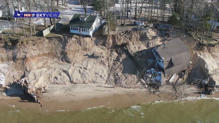
As more precipitation falls on the upper Midwest and temperatures continue to rise, communities all around Lake Michigan have been hunting for solutions for how to deal with a changing climate and an altered lakeshore. On the western shores of Michigan, houses have begun to slip into the lake because of eroding coastal dunes, leading homeowners to stabilize their structures, build waterfront barriers or move altogether. Last winter, a home in Muskegon County tumbled into the lake. In Chicago, city and federal officials have battled lakefront flooding with boulders and trail repairs. To the north in Wisconsin, homes, piers and sewer systems need reinforcements from an encroaching lake.
In Orchard Beach State Park, north of Manistee, Michigan, park officials are planning to relocate the historic pavilion building that overlooks the lake because of the danger of erosion.
Doug Barry, unit supervisor at the park, described moving the entire structure, a massive 400-ton limestone building with a concrete foundation, two fireplaces, a picnic area and a protected hall, as “controlled retreat.”
The shoreline at the park has been losing 6 inches of soil per year, Barry said.
“There’s a lot of different erosion going on,” Barry said. “Wind, rainfall, the waves.”
With the 70-foot bluff eroding at a rapid rate, Barry and the park staff had a difficult decision to make regarding the historic pavilion with sweeping lake vistas that hosts weddings, picnics and parties. Ultimately, Barry said they decided to completely relocate the building, built by the Civilian Conservation Corps and opened in the 1940s.
Barry said DNR officials and consultants considered shoreline stabilization, including 5-ton boulders, but ultimately believed those were not only going to change the character of the beach, the park’s most popular attraction, but provide only brief relief.
“It’s a temporary fix,” Barry said, pointing to the beach and the bluff from the stairs that lead down to the lake, its entrance closed off for the year because high water levels have made it unsafe. “Lake Michigan is going to win.”
Barry saw an episode of “This Old House” in which crews relocated a house, and he began to explore the idea of moving the pavilion. While the process has taken three years of planning and the approval of federal and state agencies, he said, it “provides a long-term solution.”
“What’s the alternative?” Barry asked. “Let history fall into the lake? We’d still have to clean it up.”
CREATIVE SOLUTIONS
The movement of sand, and its effects on the shoreline and the underwater environment, is the focus of offshore projects at Illinois Beach State Park in Zion and the Fort Sheridan Forest Preserve in Lake County, north of Chicago.
There, a consortium of agencies, including the U.S. Army Corps of Engineers, the Illinois Department of Natural Resources, private researchers and the Lake County Forest Preserves, is working to install a series of offshore reefs and underwater natural breakwalls. The goal is to protect the shoreline, including the popular beaches at the state park, but also study whether reducing the flow of sand, sediment and crashing waves along the shore will alter the character of the lake itself, the nearshore habitat, the beaches and the unique marshlands beyond.
The Army Corps, working with the Lake County Forest Preserve District and other local partners, has nearly finished a large-scale project at the Fort Sheridan Forest Preserve in Lake Forest.
The project is focused on coastal restoration and underwater habitat improvement. Out in the water, the underwater reefs, made of large limestone blocks, tree roots, small cobblestones and sand, may end up having two benefits: improving the aquatic habitat for fish and state-threatened mudpuppies while also protecting the shoreline and the nearshore lakeshore bed, said Jim Anderson, director of natural resources for the Lake County Forest Preserve District.
“We’re really hoping for them to break the power of the waves a little so when they hit the shoreline, they’re not as destructive,” Anderson said.
The reefs, constructed parallel to the shore about 100 to 300 feet out, were designed so that when the lake levels subside, they will still be underwater.
On land, preservation work on 1.5 miles of coastal bluffs, dunes and beach has involved the eradication of invasive plant species and seeding the soil, dunes and ravines with native plants.
“A lot of these areas suffered from development that depleted habitat,” said Nicole Toth, project manager with the Army Corps’ Chicago District. “The goal of the project is to bring that back, to improve the habitat and to get these areas into more of a natural state.”
The project, authorized under the Great Lakes Fishery and Ecosystem Restoration program, costs an estimated $14 million, shared between the federal government, the Lake County Forest Preserve District, Openlands, the city of Lake Forest and Lake Forest Open Lands Association. Most of the federal share, about $9.1 million, was funded with Great Lakes Restoration and Initiative funds received from the U.S. Environmental Protection Agency.
The Army Corps’ Chicago District has been working on more than a dozen similar projects, mostly in urban areas along Illinois’ North Shore.
A few miles to the north, scientists are studying how the lake is interacting with the shore and exploring nature-based solutions to help protect the beach and the nearshore habitats; blunt the force of the waves, especially in record-high levels; and slow the movement of sediment and sand.
Jack Cox, a coastal engineer with Edgewater Resources who is a scientific consultant for lakeshore projects, including at Illinois Beach State Park, has been studying how waves act and react to the lake bed and the shore. Cox is using a giant physical model of the Lake Michigan coast at a facility in Wallingford, England. Cox and others built a model — so large you can enter it with waders — of the shoreline so they could see how waves form, react as they crash into the shore and affect the movement of sand.
But waves, even if people cannot see them from the shore, are also busy churning under the surface, scouring the lake bed when the water becomes shallow near the shore and carrying sand along with it.
Weather patterns have pushed sand and sediment southward for years. But as people built more harbors, piers, docks, breakwaters and paved over sections of the shoreline, sand has become trapped along the way by all of these structures, Cox said.
“Sand wants to move in one direction or the other,” Cox said. “All the sand or sediment wants to move south toward Gary. If we had never settled all of this, Gary, Indiana, would be the world’s greatest beach.”
Cox said it can be helpful to imagine a zigzag pattern, where a wave comes in at an angle toward the shore, recedes, then zags back to land. At developed sections of the lake, with hardened landscapes of structures like Chicago, the waves bounce back more forcefully and can scour more powerfully.
At Illinois Beach, where there is 5 to 6 miles of natural shoreline, the goal of offshore, underwater barriers is to slow the scouring and the damage that waves can do to the beach and the unique marshlands beyond.
“And we want this to be as natural or as invisible as it can be,” Cox said.
The ideas range from underwater reefs, like to the south at Fort Sheridan, to offshore islands to underwater breakwaters. Success, Cox said, is a project that holds the shoreline so it does not retreat any farther. It may also have the added benefit of protecting onshore bird habitats and nesting grounds, and underwater fish habitats.
“It may be even able to cause a beach to be self-healing,” Cox said.
LAKE VS. HUMANS
In some communities like Saugatuck, Michigan, and the North Shore in Illinois, homeowners have put up their own barriers of boulders or breakwalls to hold back the lake. But officials are increasingly opposed to this piecemeal approach because it merely pushes erosion problems to neighboring properties or blocks public access to the lake.
With cotton clouds hanging low in the sky, whitecaps churned toward the shore of Oval Beach near Saugatuck, the southwestern Michigan town popular with many Chicagoans. The beach attracts tourists, walkers and bodysurfers to the white sand and sandy bluffs covered in dune grass.
Here, the tug between nature and human protection efforts is on full display. To the south of the public beach, dozens of expensive homes have prime lakefront property. As the lake rises and the waves do their work, the beaches and bluffs have been eroding, forcing some homeowners to seek remedies such as seawalls or stone barriers.
At the spot where the public land ends and private property begins, a sign was staked into the ground with a notice from the Michigan Department of Environment, Great Lakes and Energy, permitting 213 feet of large stones “to protect against lakeshore erosion.”
A steady stream of visitors gawked, some shaking their heads, and took photos of the sign and the giant boulders at the water’s edge.
Among them was Kathleen Johnson, a retired teacher who has lived in Saugatuck for 40 years.
“It looks terrible,” Johnson said. “It’s brutal. It changes the way the lake reacts.”
The new structures and breakwalls also prevent people from being able to walk along the beach, since Michigan law allows the public to access the lakeshore as long as they are right along the water’s edge.
Johnson’s beach-walking route has been altered by seawalls and stabilization efforts.
“That’s impossible now,” she said.
To the north, on the other side of the Kalamazoo River, a battle is ongoing over the future of land near Saugatuck Dunes State Park. Developers are eager to build homes and a marina on the riverbank, at a protected inlet not far from the lake. Others aren’t keen on the idea, including David Swan, president of the Saugatuck Dunes Coastal Alliance.
“The only thing wrong with Saugatuck Dunes State Park: It’s too small,” Swan said.
The coronavirus pandemic, he said, has only underscored the benefits of outdoors parks and preserves, as people search for safe places for exercise, fresh air and space away from other people.
“Our public lands are being threatened up to the line by proposed development,” Swan said. “We need these natural areas more than ever.”
AN UNCERTAIN FUTURE
At an Environmental Law and Policy Center virtual event in early September, Chicago Mayor Lori Lightfoot acknowledged that high lake levels, shoreline flooding and access to clean water are continual challenges for city officials as they look to a more sustainable future.
Lightfoot said the city needs to rethink how it approaches the lakefront, work with federal partners to secure funding for projects and make sure residents understand the dangers and risks of shoreline flooding.
Millions of dollars have been spent and allocated for beach repair, revetment work and shoreline protections along the city’s lakefront, from Juneway, Howard and Rogers beaches in the north to Promontory Point near Hyde Park and the shoreline to the south.
A group of Great Lakes mayors has estimated that in the last year alone, high water, flooding and erosion has caused $500 million worth of damage in cities throughout the region.

In January, Gov. J.B. Pritzker issued a state disaster proclamation for Cook and Lake counties that helped municipalities apply for federal funding.
Lake Michigan set a monthly high mean record for each month in 2020 from January through August. The lake was nearly 3 feet higher than usual for early summer, and levels came close to reaching the all-time high, recorded in October 1986, according to the U.S. Army Corps of Engineers, which maintains the official records. This fall, lake levels have fallen, and the Army Corps forecasts that they will remain flat or drop until the spring, when levels typically rise during the thaw.
However, in the National Oceanic and Atmospheric Administration’s winter forecast for the Great Lakes, there is an increased chance for above-normal precipitation and snow accumulation. If that occurs, it increases the chances for more runoff and flooding. NOAA also notes that the potential for more ice on the lake later in the winter, caused by colder than normal temperatures, may result in less evaporation from surface water, keeping lake levels high. When you combine those factors, Lake Michigan may be on the path to high lake levels again next year.
Last year was the second-wettest year on record in the United States, according to NOAA’s National Centers for Environmental Information. Chicago was pelted by 49.54 inches of precipitation, which ranks as the third wettest year on record and more than 12 inches greater than normal, according to the National Weather Service. Since Illinois meteorologists began collecting precipitation records in 1871, four of the top five wettest years in Chicago have occurred in the last decade.
Air temperatures are also on the rise. Last year was the second warmest year since records began to be collected in 1880, NOAA reported. The warmest was 2016, aided by El Nino events. Rising temperatures and increased precipitation are linked, scientists said.
OUT OF BALANCE
As climate change contributes to the warming of Lake Michigan’s more shallow waters, scientists across the Midwest are studying how changes in air and water temperature are altering the water, aquatic life and the proliferation of invasive species.
Joel Petersen, a fourth-generation commercial fisherman and captain of the “Joy,” which uses Fishtown, the historic and functional fishing village in Leland, Michigan, as its home port, said invasive species like the quagga mussel have upset the bottom food chain, altering the fish species at the higher end. With tiny snails and shrimp populations dwindling, he said, chubs have vanished and whitefish are scarce.
“With the food web all screwed up, it takes the whitefish a lot longer to grow,” Petersen said. “It’s been decimated from top to bottom. The whole thing’s out of balance.”
University of Minnesota researchers Tedy Ozersky and Sergei Katsev have been studying the effect of the quagga mussels on the biology and chemistry of the lake.
What they have found is that the quagga mussels, an aquatic mollusk native to Ukraine that arrived in ballast water from transoceanic vessels in the early 1990s, have outcompeted zebra mussels — which two decades ago were the more prolific invasive mussel — in the deep, offshore regions of the lake bottom.
Their impact stretches beyond changing the bottom of the food web. Their proliferation has filtered the water and changed the chemistry of the sediment. When the researchers lowered a camera into the water, they were surprised at not just how many mussels they saw, but also how active they were.
“It looked like they were having a party,” Ozersky said.
The invasives, he said, can filter 200 meters of lake in a matter of days, pulling the nutrients from the water, stealing them from other creatures that need them to survive.
For Petersen, the upending of that underwater interdependence has had a direct connection to how many fish he is able to catch. Peterson once caught 250 pounds of fish in the waters surrounding the Manitou islands, to the west of Leland. Now, it’s down to about 30 pounds a week.
“We don’t get very many,” he said.
The fish Petersen does catch he sells to Carlson’s Fishery, the popular shop in Fishtown. On an early fall weekday, the coronavirus a constant worry, the shop still had a line out the door during lunchtime.
Petersen is not sure how much longer he will be able to make a living out on the lake.
“You don’t want to stop,” he said. “But there might be a time when you have to. You never know what next year might look like.”
HISTORY ENDURES
The recent high water levels also have ravaged Fishtown, where on a blustery autumn day people bundled up in windbreakers and sweatshirts still flocked to the village on the fingertip Leelanau Peninsula. In bad weather, storm surges cause short-term flooding, swamping the wooden shanties, shops, pier, docks and walkway along the Leland River near where it empties into the lake.
The Fishtown Preservation Society has been working to raise the buildings and docks, many of which have been around since the early 20th century. The cost of all of the work will be at least $500,000, said Amanda Holmes, the society’s executive director.
“We keep having to add new projects,” Holmes said.
But while high lake levels and river flooding have led to changes, Fishtown’s unique northern Michigan location is part of its appeal.
“It can be so mesmerizing to be in a place where you are able to be one with the weather,” Holmes said.
The effort, and cost, is worth it, Holmes said. The society receives donations from people in 46 states, and many of those who stroll the docks and check out the shops at Fishtown are repeat visitors from across the Midwest. One of the recent catchphrases is “Save Our Shanties.”
“This is a place,” Holmes said, “that people have loved for a very long time.”
The challenge, she said, is to protect the buildings while maintaining and preserving their character.
“You just endure,” Holmes said.
–––
(This story received financial support from the Pulitzer Center’s Connected Coastlines initiative.)