
USA Today
It’s everywhere: Sea-level rise’s surprising reach damaging more than East Coast shoreline
Kelly Powers and Dinah Voyles Pulver – February 5, 2023
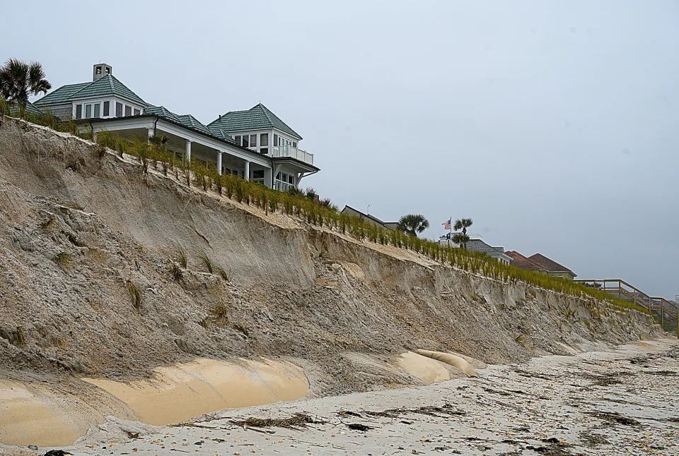
A walk down this 6-mile stretch of Florida beach might feel different than others.
Some things are the same. Rolling waves reach into smooth sheets, polishing the beach. Seaweed and shells tumble and settle, tumble and settle.
Look to the land, and the view is unexpected. Dunes have been carved into jagged cliffs. Strange canvas tubing pokes out of eroding sand mounds.
Keep walking and the view changes again. Newly imported plants grip a rebuilt dune, the result of an expensive human project.
Ponte Vedra Beach is just one place that provides a firsthand view of all the problems storm surge and high tides and sea-level rise bring in with them.
Seawalls jut from the sand, blamed by some for additional erosion elsewhere. Residents installed over 2,000 feet of geotextile tubing along the beaten dunes, with mixed results.
Meanwhile, their homes peer over a sand cliff’s edge.
“People are trying to beat Mother Nature,” said Nancy Condron, who built a home on this beach with her husband in 2008. “And what they really need to do is move their structures back and have a natural dune.”
Condron has been vocal in her opinions, having built west of the state’s coastal construction limits, but debates persist.
“It’s depressing.”
Sea-level rise is deeper than tides, more than the beach
This slice of Florida nearly captures sea-level rise in its full scope.
The sea advances on St. Johns County with a deadly combination of naturally higher tides, empowered storms and saltwater intrusion. It will impact generations of businesses, deeply historic neighborhoods, freshwater public supply wells, sparkling new subdivisions and oceanfront mansions alike.
But accelerated sea-level rise isn’t just a beachfront problem.
From threatened heritage to salty forests, oyster farms and inland flooding, voices across the region show this threat and its mitigation are far more complex than higher tides.
The rising sea reaches places you would not expect.
One tide gauge in the nation broke its record for high-tide flood days over the past year.
It was far inland, just outside Delaware City along Delaware Bay and about 20 miles from Wilmington, Delaware.
Places up and down the entire East Coast are menaced by sea-level rise’s impacts compounding the force of tides and storms: centuries of Black history, generations of businesses on Philadelphia’s Schuylkill River, headstones in colonial New England cemeteries, millennia of indigenous Florida heritage.
One of the oldest Black American communities feels current turning against them
She raised all the air conditioners 18 inches.
Lincolnville Museum and Cultural Center’s executive director Gayle Phillips in St. Augustine doesn’t have the budget to approach large mitigation projects, so she makes hands-on fixes. “We didn’t want to invest in AC units that were just going to be subjected to flooding,” Phillips said.
The effort came after Hurricane Matthew. Across much of Lincolnville’s east and south sides, flooding occurs during high tide and heavy rain.
Phillips is no stranger to taking her shoes off to get to work.
The museum, cradled by its historically Black neighborhood of Lincolnville, is devoted in part to celebrating the history of those taken involuntarily over this ocean centuries ago.
St. Augustine is the oldest continuously occupied European settlement in the country. Tourists come for its history, architecture and the white quartz sand of its beaches.
Now St. Augustine is fighting the sea to preserve indigenous artifacts, colonial Spanish antiquity and modern Black history. Newly freed slaves established the now-historic district of Lincolnville inside a city already more than 450 years old.
In 1964, Lincolnville hosted a famed Martin Luther King Jr. sit-in. Not only would King be arrested in St. Augustine that June, he would be in the city to learn the Civil Rights Act had passed.
History is baked into these 45 blocks of southwest peninsula.
The Lincolnville museum finds itself in competition with historical settlements, buildings and landmarks all around it for precious funds to preserve its own piece of heritage — in a place where there’s almost as much history as there is water.
Water’s winning.
But Lincolnville is just one neighborhood, and competition for funding is already steep. Phillips is not alone in her concern that the history she safeguards will be sacrificed for something more popular.
She said the Lincolnville museum cannot afford drainage improvements to its parking lot right now. It could be hard to imagine visitors taking off their shoes, wading through frequent flood waters, to reach her doors.
Lincolnville didn’t rank as highly as the Castillo de San Marcos fort, among other sites, in a recent city assessment of archaeological value. Historic tourism is worth $2.9 billion.
Pennsylvania brewpub fights back against storms, tides and sea-level rise
Up and down East Coast states, impact reaches well inland of the high tide line.
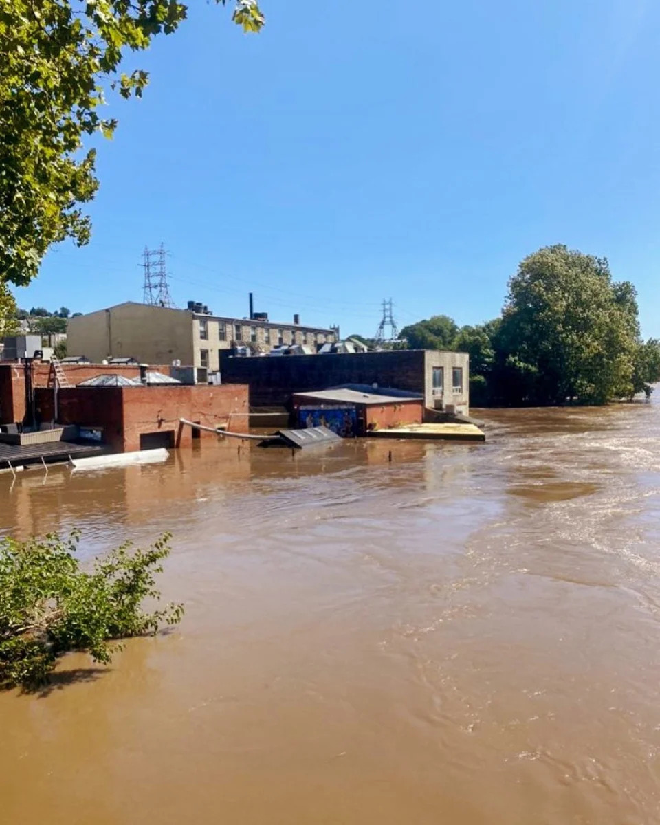
Mike Rose watched the damage unfold under a clear sky.
After the raging storm commanded attention all night, Pennsylvania officials continued to warn of a Schuylkill River surge near Philadelphia. More than 17 feet was expected by 8 a.m. It crested just short of that.
Rose watched from an off-site monitor as the cameras streamed the destruction until the power went out. The 66-year-old is used to occasional flooding, but this was different.
He returned to nearly three feet of mud.
Gelled between toppled equipment, saturated walls and debris, brown slime coated the guts of his restaurant. Massive brewpub tanks had been lifted and dropped. Remains blocked any path to Manayunk Brewing Company’s back patio, typically overlooking a quietly flowing river, several yards below.
“Did I think I was going to open up this time? I didn’t think so,” Rose recalled, perched at the bar. “I said: ‘I don’t know if I want to do this. I’m stripped. I’m just stripped of strength.”
He swiped through photos on his phone. Employees shoveled mud. Ruined wiring ripped from the walls. Pieces of kitchen equipment were shoved in a heap against the iron street gate.
From the Chesapeake to Massachusetts bays, Ida brought surges several feet above typical high tide levels.
Rising seas can spell problems for inland communities. High tides and strengthened storm surges push water higher in nearby rivers during extreme storms, and into floodplains.
Rivers across Pennsylvania and New Jersey broke record levels.
Higher tides also push back on rivers, preventing flow back into the sea. Meanwhile, fresh water from extreme rainfall can start stacking up.
If it can’t drain into watersheds, it will find new routes.
Charged by climate change, stronger storms expose weaknesses
“Hurricanes have multiple elements or drivers or mechanisms here,” said Ning Lin, associate professor of civil and environmental engineering with Princeton University. “Sea-level rise is one piece.
“Looking at the joint probability between rainfall and surge, with sea-level rise, we found that extreme joint hazards can become much more frequent in our future climate.”
The strongest drivers for this, Lin said, are more intense rainfall — as a warming planet draws more water into the atmosphere, contributing to heavier storms — and a rising sea.
She said more research is needed to model for these impacts, together. Ida already exposed mid-Atlantic infrastructure shortcomings.
Rose may feel too busy for all the science. He has his third restaurant to run.
Nearly $2 million in Ida repairs later, the brewpub reopened in February. Repairing beer tanks proved too expensive. “We’re not making our own beer anymore,” Rose said. “That’s devastating to us.”
Kitchen equipment sits on wheels. Newly polished floors replace any carpeting. Electric panels were moved to the second floor.
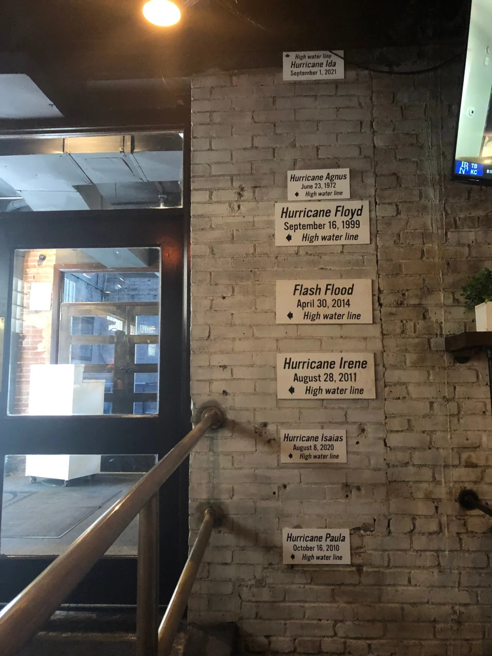
Over Rose’s shoulder, small signs climb the gray bricks. Markers for Hurricane Irene, Hurricane Isaias, an unnamed flash flood in 2014, Agnes in 1972 — the various high-water lines stretch back to the building’s time as a wool mill. Black arrows mark floodwater peaks.
The edge of Ida’s small, white sign meets the ceiling. And it points up.
Underground, another waterline snakes its way inland.
Saltwater seeps underground into critical freshwater wetlands
Only the notes of historians remain to tell the story of the Pamlico people.
They lived along the Albemarle and Pamlico sounds for thousands of years, on the now-North Carolina coast, gliding dugout canoes through wetland forest threaded with teeming creeks and rivers.
This is “TaTaku” — where land and sea meet the sky — but the Pamlico vanished within 150 years of European settlers’ arrival. Men, women and children were decimated by smallpox and absorbed into other tribes.
Scientists fear the Albemarle-Pamlico Peninsula could follow a similar path. Freshwater wetland forests and shrubby evergreen bogs could be decimated by rising seas and absorbed by advancing coastal marsh.
Wildlife refuges protect more than 450,000 acres, hosting migratory birds, rare pocosin peat bogs and the sole wild population of red wolves in the nation. Today, fewer than two dozen remain.
With no escape, the cedars, pines and pocosin bogs starve under an onslaught of rising water. On this peninsula, Atlantic white cedars have virtually disappeared.
Sea water presses forward into the estuary, past Outer Banks barrier islands. Salinity levels creep higher, pushing into groundwater supplies and washing overland during high tides and storm surges.
These rolling pulses already arrive more often.
Once the sea water arrives, trapped by roads and other changes in elevation, it can stay for weeks, or even months — saturating the roots of the trees.
Forests could be completely overtaken, said Elliott White Jr., assistant professor at Stanford University. Satellite photos show the landward march. A dense, brown fringe “gets thicker and thicker year after year.”
If the losses documented over 25 years continue without widespread restoration, White said, the wetland forests could disappear by the end of this century.
The insidious flow of salts below ground also threatens freshwater wells and agriculture across the region. Farmers on the peninsula, who raise corn, soybeans, wheat, potatoes and cotton, have seen salt in their fields, said Rebekah Martin, Coastal NC National Wildlife Refuges Complex project leader.
Ghost forests appear and spread almost invisibly
When sea level rises and salt water floods coastal forests, it kills the trees. What’s left behind is called a ghost forest: https://oceanservice.noaa.gov/facts/ghost-forest.html…#OceanMonthNOAA
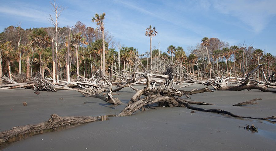
“Ghost forests” can grow almost slowly enough to miss. Yet these dying woods appear from Maine to Miami, bending back along the Gulf of Mexico.
Stripped of their leaves and bark, trees become gaunt skeletons. Gradually forests and bogs give way to more salt-tolerant thickets.
“I’ve seen palm tree ghost forests in Florida and red spruce ghost forests in Canada,” said Matt Kirwan, associate professor with Virginia Institute of Marine Science. “They all share a similar origin.”
A group of University of South Florida researchers concluded the Big Bend’s coastal forest is dying at “an unprecedented rate.”
Hurricane Sandy left a ghost forest of white cedar in New Jersey.
In the Chesapeake Bay region, more than 80,000 acres of forest have turned to marsh in the last 150 years. That number could increase fivefold by 2100, Kirwan predicts.
New corridors would have to be considered for wildlife to retreat, Martin said. And more people and places could be exposed to intensifying storms typically buffered by marsh.
On the Albemarle-Pamlico Peninsula, once-vital forests could be lost to history.
Unwitting oysters part of a plan to fortify shorelines
Rolling between Scott Budden’s fingers, a baby oyster resembles a grain of sand. Its tiny shell, still translucent in the gray morning, is already the perfect shape.
Its life with Budden begins here on Kent Island, Maryland. Farmers must tailor the crop’s controlled life cycle with the whims of changing waters, rising tides and shifting salinity.
After outgrowing land tanks, having savored algae and phytoplankton, the adolescent oyster will eventually move north to the Chester River. Waves will crash through hundreds of similar surface floats, transferring energy to the bundled mollusks lining several acres.
The oyster will return to Eastern Bay to finish. The water is saltier down here.
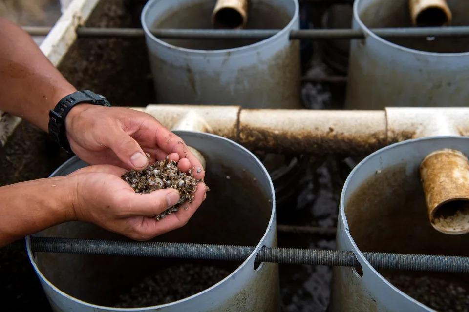

Today, his prize crop joins a growing list of natural tools to fight against the very waters that foster it. Experts say even these oysters raised for a plate can also help fortify shorelines, like millions once did on their own.
“Growing the shellfish aquaculture industry can benefit the entire ecosystem,” said Joseph Gordon, U.S. East Coast project director with Pew Charitable Trusts. His group co-sponsored an initiative to buy millions of oysters from farmers like Budden, who were lacking the usual restaurant demand, and re-establish them in the bay.
The initiative’s reach extended to shellfish growers up the mid-Atlantic and New England, following an idea that has established itself to grow much like the oysters themselves: Mitigating climate change can mimic the natural world.
What’s a living shoreline?
One farm offers a payoff Budden doesn’t often consider.
On a stretch of coast, he notices an exposed beach has slowly washed away. But the same erosion, near Eastern Neck Island, Maryland, isn’t seen on his side.
“I’ve noticed there’s some dampening effect,” said the 36-year-old. “Basically, as waves come through, the energy is transferred to the floats, the floats then transfer that energy to the oyster. Which, actually, makes a better oyster.”
His casual observations echo the experts and other projects. Mitigations have been moving “from gray to green” to combat the effects of rising sea.
“For a long time, when we needed to stop erosion along the shoreline, we put in a hard structure,” said Molly Mitchell, a research assistant professor with the Virginia Institute of Marine Science. Think bulkheads, riprap, seawalls.
“They don’t provide good habitat for animals, and they don’t have the other benefits of natural beaches and marshes, like actually reducing wave energy.”
“Living shorelines” — from adding marsh and grass, to building shellfish breakwaters — have been growing in popularity as an alternative to shoreline hardening.
Oyster reefs once thrived on Eastern shores, before humans decimated populations in the early 1800s. Oysters built on top of one another as others died, creating a solid structure.
“Rocks and seawalls aren’t going to evolve as the water gets steeper,” Mitchell said. “If you use an oyster reef, the oysters will actually grow on it — and the structure will get taller and taller as sea level rises.”
It can’t work everywhere. These solutions take best to systems with more moderate wave energy, like the Chesapeake Bay, or rivers and sounds.
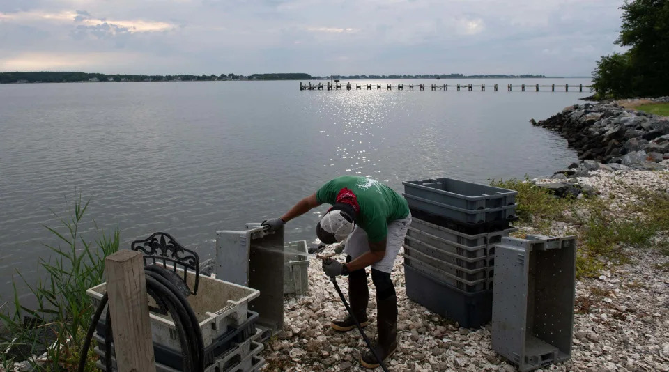
Back at the dock, Budden and his team watch saltwater drizzle through a churning tumbler, cleaning their harvest. Those measuring too small plunk back to the bay below.
His crop has always had a role to play in protecting the coast, but today shoreline communities may need to get more creative.
“We’ve got a couple million market oysters in the water, another three or four million have been put through the nursery this year,” he said. “Still, just a drop in the bucket.”
This article is part of a USA TODAY Network reporting project called “Perilous Course,” a collaborative examination of how people up and down the East Coast are grappling with the climate crisis. Journalists from more than 35 newsrooms from New Hampshire to Florida are speaking with regular people about real-life impacts, digging into the science and investigating government response, or lack of it.