50% of U.S. Lakes and Rivers Are Too Polluted for Swimming, Fishing, Drinking
Olivia Rosane – March 29, 2022
A steel mill on Indiana’s Grand Calumet River. Cavan Images / Getty Images
Fifty years ago, the U.S. passed the Clean Water Act with the goal of ensuring “fishable, swimmable” water across the U.S. by 1983.
Now, a new report from the Environmental Integrity Project (EIP) finds the country has fallen far short of that goal. In fact, about half of the nation’s lakes and rivers are too polluted for swimming, fishing or drinking.
“The Clean Water Act should be celebrated on its 50th birthday for making America’s waterways significantly cleaner,” EIP Executive Director Eric Schaeffer said in a press release announcing the report. “However, we need more funding, stronger enforcement, and better control of farm runoff to clean up waters that are still polluted after half a century. Let’s give EPA and states the tools they need to finish the job – we owe that much to our children and to future generations.”
The report was based on reports that states are required to submit under the Clean Water Act on the pollution levels of their rivers, streams, lakes and estuaries. According to the most recent reports, more than half of the lakes and rivers are considered “impaired,” meaning that they fall short of standards for fishing, swimming, aquatic life and drinking.
Specifically, around 51 percent of rivers and streams and 55 percent of lake acres are considered impaired, The Hill reported. Further, 26 percent of estuary miles are also impaired.
The Clean Water Act was a landmark legislative achievement when it was passed in 1972. It promised to end the discharge of all pollutants into navigable waters by 1985, according to the press release. However, it has fallen short of that goal for several reasons, according to the report.
The act has strong controls for pollution pumped directly into waterways from factories or sewage plants but not for indirect pollution such as agricultural runoff from factory farms.
The Environmental Protection Agency (EPA) has dragged its feet in updating industry-specific technology-based limits for water pollution control systems. By 2022, two-thirds of these industry-specific limits had not been updated in more than 30 years.
Budget cuts have hampered the ability of the EPA and state agencies to enforce the law.
Permit requirements are poorly enforced.
Total Maximum Daily Loads, a kind of pollution control plan, are insufficient.
There are problems effectively managing watersheds that cover two or more states.
The report also broke down pollution by state. Indiana has the most miles of rivers and streams too impaired for swimming and recreation.
“Indiana’s waters have benefited from the Clean Water Act, but unfortunately, they also illustrate some of the gaps in the law,” Dr. Indra Frank, Environmental Health & Water Policy Director for the Hoosier Environmental Council, said in the press release. “We have seen persistent, unresolved impairments, especially for E coli bacteria in our rivers and streams, in part from industrial agricultural runoff. And we have also seen examples of Clean Water Act permits used to send water contaminated with coal-ash into our rivers. We need to halt pollution like this.”
Florida, meanwhile, had the most lake acres impaired for swimming and aquatic life.
“Florida’s toxic-algae crisis is the direct result of lax enforcement of phosphorus and nitrogen pollution limits in cleanup plans required by the Clean Water Act,” Friends of the Everglades Executive Director Eve Samples said in the press release. “Because these limits rely on voluntary ‘best management practices’ and a presumption of compliance, agricultural polluters regularly exceed phosphorus runoff limits while dodging responsibility — leading to harmful algal blooms in Florida’s lakes, rivers, estuaries, and even on saltwater beaches.”
The report did propose several solutions that range from making sure that the EPA and other agencies carry out their duties under the existing law to strengthening the act with new legislation to control runoff pollution.
This last is particularly important because agricultural runoff and other indirect pollution sources are the leading causes of waterway pollution.
“Factory-style animal production has become an industry with a massive waste disposal problem and should be regulated like other large industries,” the study authors wrote.
German farmers in Ukraine press ahead in defiance of war
Sophie Makris – March 25, 2022
German farmers Tim Nandelstädt (centre) and Torben Reelfs (right) push ahead with their crop planting in Ukraine despite Russia’s invasion (AFP/Tim NANDELSTAEDT)
War has come to Ukraine but German farmers Torben Reelfs and Tim Nandelstaedt are planting the first sugar beets of the season on their plot of land in western Ukraine (AFP/Tim NANDELSTAEDT)
Every year in early spring, German farmers Torben Reelfs and Tim Nandelstaedt turn the soil and plant the first sugar beets of the season on their plot of land in western Ukraine.
But this year, the ritual has taken on a new meaning.
“It’s very symbolic. When the machine turns over the land, it’s a different feeling than in previous years,” said Reelfs, 41, speaking to AFP by phone from the farm about 60 kilometres (37 miles) from Lviv.
When Russian troops invaded Ukraine on February 24, Reelfs and Nandelstaedt immediately fled to Germany to “get away from the missiles, to be on the territory of the EU, of NATO”, according to Nandelstaedt, 43.
“At first I thought that Russia would get to the Polish border very quickly,” he said.
But three weeks later, both of them were back in Derzhiv, their adopted home for the last 10 years.
“What we are seeing here, the solidarity on a military and a humanitarian level, is inspiring and gives you hope,” said Reelfs.
– ‘Poker game’ –
With the west of Ukraine so far largely spared from the deadly fighting raging in the south and east, the two men decided to go ahead and start sowing their crops.
The pair had already managed to secure the fuel, fertiliser and seeds they needed.
They began by sowing the sugar beets, which will be followed by corn in around two weeks’ time and soybeans in around two months.
It’s too early to tell whether the crops will ever be harvested, but for now, Reelfs is sure it was “the right decision”.
He also feels “a certain responsibility” to “reduce the risk of catastrophic famines” around the world as a result of the war.
Before the Russian invasion, Ukraine was the world’s fourth largest exporter of corn and was on its way to becoming the third largest exporter of wheat behind Russia and the United States.
Corn, wheat and sunflower oil prices have already soared in recent weeks and the situation looks set to worsen if the “breadbasket of Europe” is unable to keep up with the usual supplies.
The two German farmers know that going ahead with the harvest is a huge risk — a “poker game”, according to Reelfs.
“What will happen in six months, when we harvest, I honestly have no idea,” said Nandelstaedt. “Some farms have already been hit by missiles or attacked by ground troops. Fields are burning. If that happens here, it will be over.”
– ‘Adventure’ –
Reelfs and Nandelstaedt have spent the last decade building up their farm in Ukraine, which covers 1,900 hectares of land and employs 25 people.
The business partners, who have been friends for over a decade, were among a wave of farmers who took up leases on land in Ukraine after the fall of the Soviet Union, attracted by the cheap prices and fertile soil.
They liked the idea of an “adventure” and the chance to build everything from scratch, according to Reelfs.
Between 2008 and 2009, “we visited almost 50 villages and there was still available land everywhere”, he said.
“When we started out, you could rent a hectare of land for 17 euros ($18.70) and could even pay in kind, with wheat or sugar. Today, we pay well over 100 euros here and it is more than 200 euros in many regions.”
It’s a sign of how much Ukraine has changed over the years, he said: “Corruption has greatly decreased… and the standard of living has got better and better.”
Reelfs believes it has been a surprise to the Russian forces to see that “people are not at all unhappy with their government, they want to support the army and defend their country”.
During their stay in Germany, Reelfs and Nandelstaedt collected 130,000 euros in donations for Ukraine and helped to arrange accommodation for around about 170 people in villages around Berlin.
“Even though they all feel welcome there, they want to return to Ukraine as soon as possible,” said Reelfs.
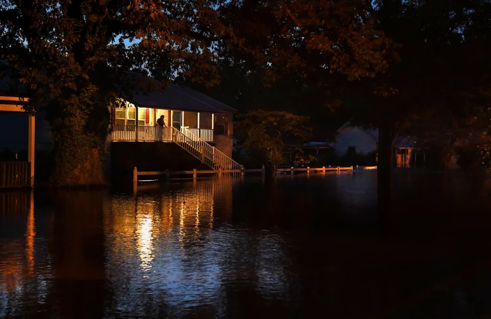
When Miyuki Hino bought a house in Chapel Hill, N.C., in 2020, she checked an online map that showed the damage caused by Hurricane Matthew in 2016 to evaluate the neighborhood.
“We wanted to know our flood risk before buying, although we’re aware that every storm is different and they can be hard to predict,” says Hino, an assistant professor of city and regional planning at the University of North Carolina at Chapel Hill. “We had to make an offer quickly, so we looked at the map and we asked neighbors about which houses nearby had flooded. We found out that our street is on a slight hill and the homes at the bottom of the hill had more trouble from that hurricane.”
Hino purchased flood insurance, which costs about $300 annually, even though it isn’t required for her home.
“Our first concern is for the safety of everyone in the house,” says Hino. “Our second concern is about property damage in case of a storm. But we’re also concerned about the long-term impact of extreme events on the value of our property.”
Not every buyer is as diligent about evaluating the potential risk of a weather-related disaster, but that may change in the future. Violent storms, wildfires, floods, droughts and extreme heat are among the increasingly visible signs of climate change. While safety issues associated with these events are of prime importance, the frequency and intensity of dramatic natural disasters are beginning to have an impact on property values and the cost of homeownership in some locations. Researchers are analyzing data to help buyers, homeowners, lenders, insurance companies and appraisers evaluate what the future may hold and how that could impact the housing market.
“Most homeowners should care about climate change and the potential impact on their families and property,” says John Berkowitz, CEO and founder of OJO Labs, a real estate technology firm that owns the Movoto listing site in Austin. “Unfortunately, the people who are most likely to be hurt are already disadvantaged in the housing market, such as first-time buyers and minority buyers who are focused on affordability now. They don’t have the luxury of time or money to think about what their property value will be in 2050.”
Lack of knowledge about climate risk makes it difficult for buyers to recognize that their home could be more costly to maintain, more expensive to insure, and more exposed to damage and possible destruction from a storm or fire. All those possibilities could also contribute to a decline in a property’s value or the inability to sell the home in the future. Yet few consumers consider these issues when buying a home.
Fires, floods and home values
Numerous studies have recently looked at the current impact of hazards on property values. For example, Redfin researchers found that homes in areas prone to wildfires sold for an average of 3.9 percent less compared with homes in areas with lower wildfire risk in California, Oregon and Washington state in 2020. Between 2012 and 2020, the median sales price of homes in low-risk areas increased 101 percent compared with an 88 percent increase in the median sales price for homes in areas with a high risk for wildfire, according to the study.
But home values don’t always correlate with climate risks. Hino co-wrote a report with Marshall Burke, an associate professor in the department of Earth system science at Stanford University, titled “The Effect of Information About Climate Risk on Property Values,” that focused on flood risk.
“Our research looked at the impact of regulatory flood plain maps, which are used to determine whether a home needs flood insurance, on home prices,” says Hino. “We expected to see that homes that require flood insurance would be less costly than similar homes that don’t require flood insurance, but that’s not happening.”
The main culprit is lack of information, says Hino.
“I read one study that found that less than 10 percent of buyers know that a house is in a flood plain before they make an offer,” says Hino. “They find out later when their lender checks the [Federal Emergency Management Agency] map to see if flood insurance is required.”
Homes in coastal areas that are prone to flooding are desirable to many buyers for their water views, which keeps their prices high. A 2021 study by Redfin researchers found that homes with a high risk for flooding sold for a premium of 13.6 percent more than homes with a low risk for flooding during the first quarter of 2021, an increase in that premium over both 2020 and 2019.
Unfortunately, FEMA maps have been found to underestimate flood risk. A study by the nonprofit First Street Foundation found that more than 23.5 million properties are at risk of flooding over the next 30 years. First Street Foundation’s Flood Factor tool, which is available to consumers, includes flood risk from urban storm water flooding, storm surge and future conditions such as rising seas.
Mortgage lenders and insurance companies rely on FEMA maps to evaluate flood risk and to inform consumers about the requirement or recommendation for flood insurance. Flood damage is not covered by regular homeowners insurance policies and therefore requires a separate policy. The Research Institute for Housing America (RIHA) at the Mortgage Bankers Association released a study earlier this year – “The Impact of Climate Change on Housing and Housing Finance” – that concluded that the housing industry lacks an accepted indicator to assess climate risk.
“There’s lots of work to do in the industry because there’s no single test for climate projections that lenders can use for risk management,” says Eddie Seiler, executive director of RIHA in D.C. “There are private companies working to build models to understand the risks to homeowners and the financial risks to lenders. Freddie Mac and Fannie Mae are working to come up with climate scenarios, too.”
Seiler says he believes that eventually climate risk may become part of the mortgage underwriting process. The report found that, in addition to increased flood risk and property damage, climate change may increase mortgage default rates, increase the volatility of house prices and possibly produce climate-related migration patterns. If people choose to move away from areas with high risks from fires, floods and storms, that could reduce property values in those communities.
“After Hurricane Katrina, the mortgage industry didn’t know whether borrowers would default on their loans,” says Seiler. “The FEMA maps were way out of date, so people who were at high risk for floods didn’t know it and didn’t have flood insurance. In that case, the federal government stepped in. But we know that when people are underwater on their loans, they default more often.”
Another risk is that if insurance rates skyrocket, the cost of having a home would be so high that owners would be unable to repay their loans, Seiler says.
“Insurance companies raise rates as much as 20 or 30 percent in high-risk areas compared to low-risk areas,” says Brian O’Connell, a senior insurance analyst at InsuranceQuotes.com in Bucks County, Pa. “Buyers should expect to see rates increase as we see more floods, fires and heat waves. Alternatively, some insurance companies may simply get out of the business, which could also increase costs because of the lack of competition for customers.”
Some insurance companies also raise the deductible for specific events such as hurricanes, which leaves homeowners responsible for thousands of dollars of repair costs, according to O’Connell.
Consumers and climate risk
The unpredictability of climate change makes it difficult to evaluate the risk for a specific event to occur at any particular property. Even wildfires sometimes skip over some homes. Hurricanes and tornadoes have uneven impacts on homes within the same neighborhood.
Another obstacle for home buyers is that seller disclosure rules vary by jurisdiction. Sellers are not always required to share information about risks associated with natural disasters or previous damage.
“We found that in states with stricter disclosure laws there was a higher correlation between pricing and flood insurance,” says Hino. “In states such as Louisiana, Texas, Oklahoma and South Carolina, home prices are lower on homes that carry a risk of floods because buyers are aware of the risk.”
One solution is to provide data about possible future increases in storms and extreme heat directly to buyers and to real estate agents who can share that information with house hunters, says Berkowitz. Movoto includes information on climate risk for each listing on their site from ClimateCheck.
“Consumers can look now at listings on sites such as Redfin and Realtor.com for flood risk scores and climate scores,” says Seiler. “That helps to get people thinking earlier about the potential risk from floods, fires and storms.”
Consumers can also go directly to sites such as ClimateCheck, Flood Factor, Attom Data Solutions Home Disclosure Report and CoreLogic’s RiskMeter to review hazard risks that include storms, floods and wildfires.
“We’re working with climate scientists to develop analytics on what climate change means, such as whether there will be more hurricanes or stronger hurricanes and whether the issue will be storm surges or high winds,” says Tom Larsen, principal for insurance and spatial solutions at CoreLogic, a data analytics firm based in Irvine, Calif. “The challenge with these perils is that you don’t see identical damage to each house. So we use our spatial modeling to look on a granular level at every house. We can look at the elevation above the sea level of the first floor of a house and follow wildfire patterns property by property.”
Since CoreLogic primarily provides analytics to industry professionals such as insurance companies and lenders, its focus is on what it would cost to repair or rebuild a property. Mortgage and insurance companies need the information because of their financial commitment to the property.
“Consumers want to know if their home will lose value, but it’s tough to evaluate the market price of a property versus the physical cost of rebuilding,” says Larsen. “But consumers also need to know their total cost to live in a home. Eventually, I think predicting insurance costs based on climate risk will become part of the mortgage process because it’s part of the cost of ownership.”
For buyers today, assessing the potential cost from climate risk is one more thing to pay attention to and is challenging to evaluate, says Larsen.
“Eventually, we’ll get to the point where people can see an average score that demonstrates what the risk is now, the expected cost of possible damages and a prediction of future potential costs,” says Larsen. “That’s not necessarily to tell someone not to buy someplace, but to help them understand the risk they’re accepting by buying in certain locations.”
O’Connell recommends hiring a good buyers’ agent who will warn consumers about high insurance costs or elevated risk for natural disasters.
“Buyers should do their due diligence and check insurance premiums ahead of time for different areas, so they understand what they’re getting into if they choose to buy near water, for example,” says O’Connell. “They should also read their insurance policy, so they know what happens if there’s a weather event and to make sure they’re covered for a wildfire or wind damage. If they’re not comfortable reading it, they should ask a lawyer to review it or talk to an insurance expert.”
Buyers may want to factor in costs related to adapting their homes for climate change, says Berkowitz.
“For example, homeowners in places that are beginning to see more severe winters need to consider the cost of winterizing their homes with more insulation and better windows,” Berkowitz says. “Homeowners in traditionally cooler climates like Seattle are finding themselves investing in air conditioning now that the summers are hotter there.”
Climate awareness has received a low level of attention so far, but that won’t last forever, especially as climate risk increases, Berkowitz asserts.
However, Berkowitz acknowledges, it’s hard to predict whether climate change will decrease the desirability of homes in some areas because of safety issues or because of the higher cost of ownership. It could just mean that homes in some areas appreciate less over the next 30 years than they did over the previous 30 years.
“Home buyers and owners need to recognize the value of their house today and understand how it could change in the future,” says Berkowitz. “They need to be aware of the full cost of ownership, including maintenance and insurance and how those costs could rise.”
How to evaluate climate risk when house hunting
Check all listings on sites such as Realtor.com, Movoto and Redfin for information about climate-related risks such as floods and fires.
Ask neighbors about recent storms and damage.
Ask your real estate agent for information about floods, fires and storms in the area.
Check the address of a property on sites such as ClimateCheck, Flood Factor, Attom Data Solutions Home Disclosure Report and CoreLogic’s RiskMeter.
Depending on the local disclosure laws, ask the seller and listing agent for information about previous flood or fire damage.
Request a homeowners insurance estimate as early as possible to determine affordability.
Ask a home inspector to look for evidence of previous storm or fire damage.
Find out if storm-resistant features have been added to the house, such as hurricane shutters, stronger windows and mesh coverings for vents in fire-prone areas. If not, ask for a cost estimate to add those features.
Ask if the community is taking steps to mitigate storm risk.
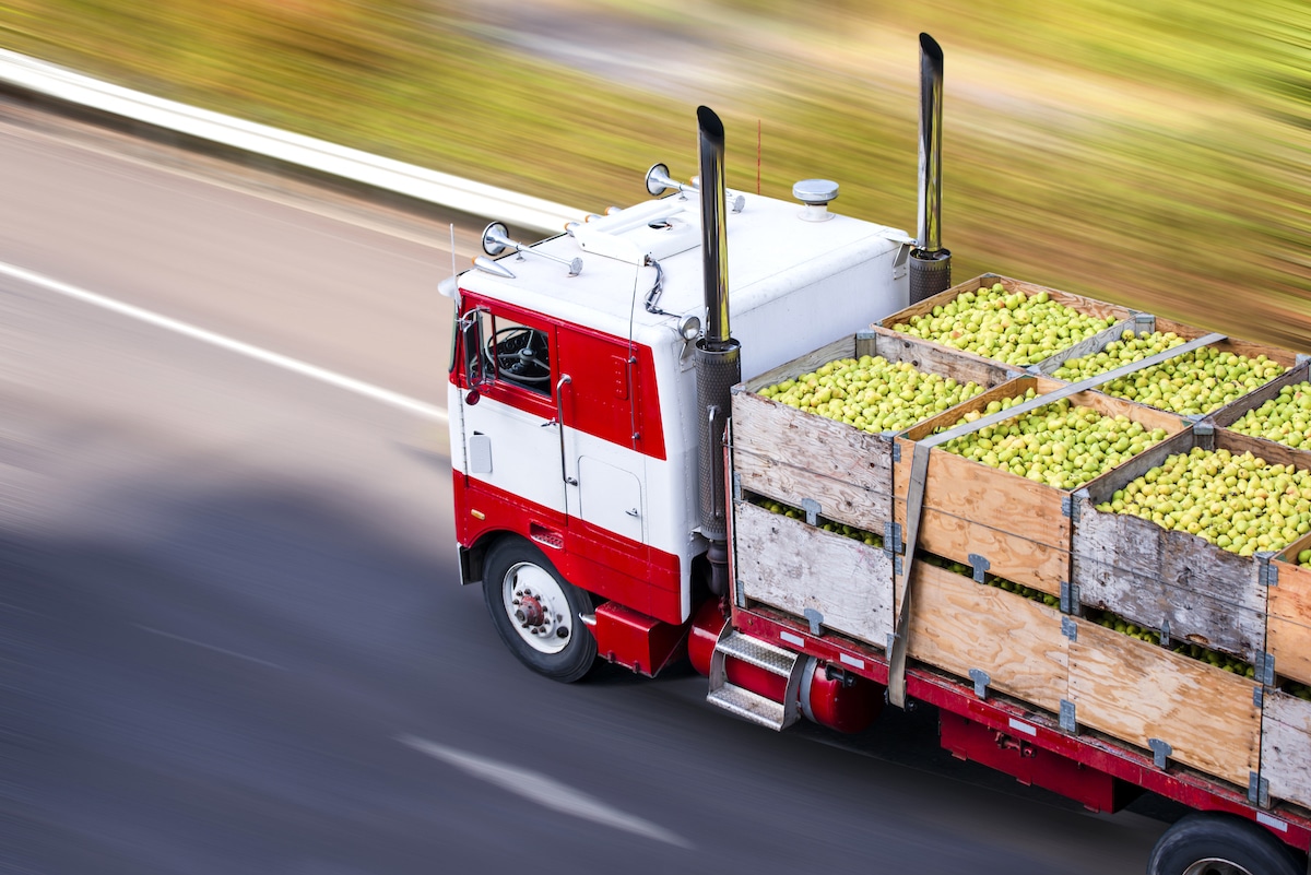
A big rig semi truck transports boxes of pears. vitpho / iStock / Getty Images Plus
Food travels long distances – sometimes hundreds or thousands of miles – to reach our plates. Mapping the trajectory of many processed foods is to draw zig-zags across the globe, connecting faraway fields, factories, distribution centers, and store shelves.
The concept of “food miles” was created in the 1990s to warn consumers of the connection between long-distance food transportation and mounting global carbon emissions. Recent estimates figure that, in the U.S., processed food typically travels over 1,300 miles and fresh produce over 1,500 miles before it’s consumed. Ultimately, the further food travels, the more fossil fuels are needed, which in turn results in more greenhouse gas emissions that fuel climate change.
Just 10 companies – among them Nestlé, Mondolez, and Unilever – control almost all large food and beverage companies in the world. This concentration of food suppliers has left less room for small, local farmers, and means more and more of our food is transported across the country – or the globe – before being eaten. Take Iowa, for example: in 1870, 100% of all apples consumed in the state were also produced there. By the end of the 20th century, however, only 15% of apples consumed were produced by Iowa farmers.
The globalization of our food supply has also allowed consumers to become accustomed to foods grown only in other regions – think of coffee, which isn’t grown anywhere in the contiguous U.S. – or out-of-season foods that must be transported from warmer climates. Strawberries bought at a local farmers market during their summer growing season, for example, will have a lower food mileage than those shipped from California and purchased at a grocery store in December.
Different methods have been employed over time to calculate food miles. The Weighted Average Source Distance (WASD) formula was developed by Annika Carlsson-Kanyama in 1997, and considers the weight of the transported food and the distance it travels from the place of production to the place of sale. To analyze foods with multiple ingredients – including many processed foods, like bread, packaged desserts, snacks, etc. – The Leopold Center for Sustainable Agriculture developed the Weighted Total Source Distance (WTSD) formula, which calculates the weight and distance traveled of each individual ingredient.
How Are Food Miles Calculated?
The WASD and WTSD are helpful formulas, but the Weighted Average Emissions Ratio (WAER) formula – developed in 2004 by the nonprofit LifeCycles – also takes into account the greenhouse gas emissions associated with the mode of transportation employed. So, it’s not just the literal miles traveled that matters, but the means by which it’s transported.
The Impact of Faraway Food
Both transportation and agriculture are major culprits in human-caused climate change. In the U.S., transportation accounts for the largest share of national greenhouse gas emissions, and, according to the IPCC, agriculture accounts for one-fifth of all global CO2 emissions. The U.S. food system alone consumes more energy than all of France annually.
Within the food system itself, transportation comprises 14% of all energy used, but greenhouse gas emissions are also related to where the food was produced: The Leopold Center found that conventionally-sourced food uses 4 to 17 times more fuel than local food, and produces 5 to 17 times more CO2. For processed foods, the impact is even larger. Think of a frozen lasagna: the wheat for the pasta might be grown in Kansas, the tomatoes and spinach for the sauce in California, the beef raised in Texas, and the cheese made in Wisconsin. Some of these materials might even need to be transported from the farm to another location to be processed – like the wheat to be made into sheets of lasagna noodles – then to the factory to be assembled, packaged, and finally shipped to grocery stores.
Food miles also take into account the mode of transportation used – by water, road, rail, or air, in order of efficiency – which are not all created equal; transporting food by plane creates 50% more greenhouse gas emissions than food transported by sea. A 2005 study found that while air transportation only accounts for 1% of food transportation in the UK, it is responsible for 11% of the country’s emissions.
Food mileage should also include how the food is procured by the customer. In our car-based society, where car-ownership rates by household have remained above 90% for a decade, many shoppers drive to a store to purchase their groceries. In 2015, researchers found that the median distance to the nearest food store for Americans was 0.9 miles, and that 40% of the population lived further than 1 mile from a food store, necessitating a car for many people in order to do their shopping.
Debate Over Food Miles
Climate and agricultural scientists don’t all agree on the benefits or accuracy of food miles when determining the environmental impact of food products.
Many argue that this metric doesn’t take into account the whole carbon footprint of an item, or its non-emissions-related environmental impacts during production, like pesticide use, water pollution, or farmers’ rights. “Working out carbon footprints is horribly complicated,” said African agriculture expert professor Gareth Edwards-Jones of Bangor University in an interview with The Guardian. “It is not just where something is grown and how far it has to travel, but also how it is grown, how it is stored, how it is prepared.”
Local food is often espoused as the greener option, but this isn’t always true. For example, the energy needed to heat a greenhouse in the Northeast to grow tomatoes in the winter might actually be a more carbon-intensive process than shipping the tomatoes from California. A Swedish study found that tomatoes imported to Sweden from Spain were actually less energy-intensive than those grown locally in greenhouses.
Some companies and organizations have instead begun using the Life Cycle Assessment (LCA) method to analyze the impact of their product. This method takes into account all stages in the life cycle of the product, from production, to processing, to packaging, to transportation, to disposal. The analysis goes beyond carbon emissions and considers other environmental factors like air and water pollution, use of natural resources, and impacts on human health.
How to Reduce Food Miles
While the benefit of food miles might be contested, lowering your environmental impact with your food choices is always beneficial.
To find the food miles of your favorite products, use this food miles calculator, or research where the product comes from. It might be unrealistic to expunge all faraway foods from your diet – given expense and convenience – but some items might be replaceable with local alternatives. Consider joining a CSA to get fresh produce from nearby farms at regular intervals, or shopping from local producers at a farmers market. Better yet, grow your own food! The only food miles to calculate will be the distance from your backyard or front stoop to your kitchen.
Eating seasonal produce will also ensure that your produce wasn’t shipped across the country to reach your plate. While you can’t always know if something was transported by plane, many perishables that need to be eaten quickly after harvesting are – like berries – so refraining from eating these products until they’re in season will cut down on air transport.
Beyond food miles, minimize your impact by cutting down on food-related emissions in other ways. Limiting or cutting out meat and dairy is among the most impactful of changes, as 57% of emissions from food production are attributed to animal-based food (including the production of livestock feed). Going fully vegan or vegetarian is great, but not imperative; just reducing animal products in your diet makes a difference. Lastly, instead of tossing food scraps in the trash, compost them at home to keep organic waste out of landfills.
THIS Is the Safest Place to Live in the US as the Climate Changes
United Nations: Climate change refers to long-term shifts in temperatures and weather patterns, mainly caused by human activities, especially the burning of fossil fuels.
Ocean’s Largest Dead Zones Mapped by MIT Scientists
Olivia Rosane – January 26, 2022
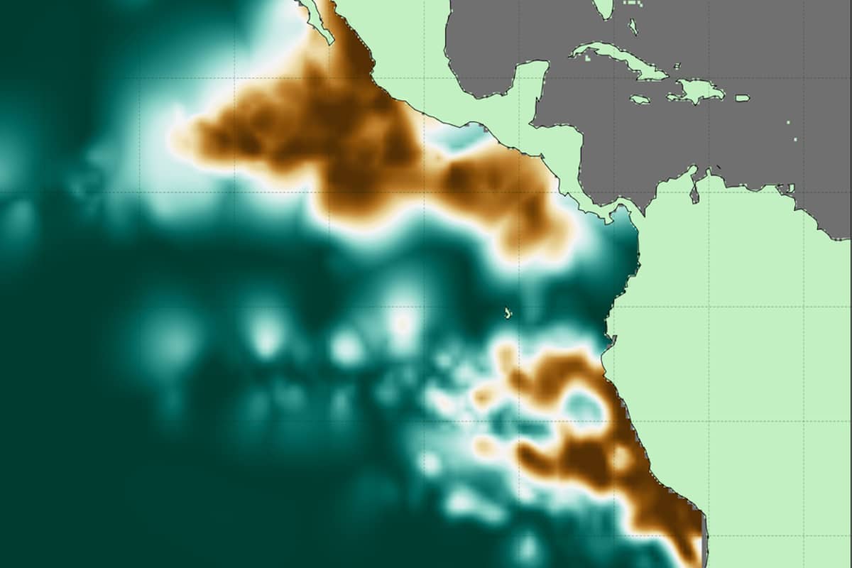
Oxygen-deficient zones intensity across the eastern Pacific Ocean, where copper colors represent the locations of consistently lowest oxygen concentrations and deep teal indicates regions without sufficiently low dissolved oxygen. Jarek Kwiecinski and Andrew Babbin
When you think of the tropical Pacific, you might picture a rainbow of fish ribboning their way between pinnacles of coral, or large sea turtles swimming beneath diamonds of sunlight. But there are two mysterious zones in the Pacific Ocean where life like this cannot survive.
That is because they are the two largest oxygen-deficient zones (ODZ) in the world, which means they are a no-go zone for most aerobic (oxygen-dependent) organisms. Two Massachusetts Institute of Technology (MIT) scientists recently succeeded in making the most detailed atlas to date of these important oceanic regions, revealing crucial new facts about them in the process. The new high-resolution atlas was described last month in the journal Global Biogeochemical Cycles.
“We learned just how big these two zones in the Pacific are, reducing the uncertainty in the measurement, their horizontal extent, how much and where these zones are ventilated by oxygenated waters, and so much more,” Andrew Babbin told EcoWatch in an email. Babbin is one of the atlas’s two developers and Cecil and Ida Green Career Development Professor in MIT’s Department of Earth, Atmospheric and Planetary Sciences. “Being able to visualize in high resolution the low oxygen zones really is a necessary first step to fully understanding the processes and phenomena that lead to their emergence,” he said.
Natural Dead Zones
Oxygen-deficient zones can also be referred to as hypoxic zones or dead zones, as the National Oceanic and Atmospheric Administration explains. They can be caused by human activity, especially nutrient pollution. For example, the world’s second-largest dead zone is in the Gulf of Mexico, and is largely caused by the runoff of nitrogen and phosphorus from cities and factory farms.
The new atlas focuses on two naturally-occurring ODZs in the tropical Pacific, however. One is located off the coast of South America and measures about 600,000 cubic kilometers (approximately 143,948 cubic miles), or the equivalent of 240-billion Olympic swimming pools, MIT News reported. The second is around three times larger and located in the northern hemisphere, off the coast of Central America.
Both natural and anthropogenic ODZs have something in common: too many nutrients. In the case of the Pacific ODZs, Babbin said, those nutrients build up because of wind patterns that push water offshore.
“Deeper water then upwells to fill in this void, bringing higher nutrients to the surface,” Babbin told EcoWatch. “Those nutrients stimulate a massive amount of growth of phytoplankton, akin to how we fertilize crop lands and even our potted plants at home. When those phytoplankton then sink, heterotrophic bacteria act to decompose the organic material, consuming oxygen just like humans do to respire our food.”
However, because of where these zones are located, it takes a long time for oxygen-rich waters to reach the area and replenish what the bacteria gobble up.
“In essence, the biological demand of oxygen outpaces the physical resupply,” Babbin concluded.
While these specific zones aren’t caused by human pollution, understanding them is still important in the context of human activity. ODZs can emit the greenhouse gas nitrous oxide, and there is a concern that the climate crisis may cause them to expand.
John Oliver explains the U.S. power grid and the challenge of upgrading it for America’s electric future
Peter Weber, Senior editor – November 8, 2021
“Electricity is such an integral part of modern life it is hard to believe that we used to have to sell people on the idea of electric appliances,” John Oliver said on Sunday’s Last Week Tonight, showing a TV ad from 1959. “Specifically tonight we’re going to talk about the power grid, the system of generators that produce electricity and the vast latticework of wires that get it to our homes. The grid is probably something that you probably don’t think much about until it goes down — which, unfortunately, has been happening more and more in recent years.”
“While things are bad now, they could get a lot worse in the future, because the U.S. has a goal of net-zero carbon emissions by 2050 — which we absolutely must meet,” Oliver said. “But one study estimates that’s going to require a 40-60 percent in peak electricity consumption,” with the shift to electric cars and heating, and “all that electricity is going to have to come from somewhere.”
The U.S. power grids — 600,000 miles of transmission lines and 5.5 million miles of local distribution lines — have been called the “supreme engineering achievement of the 20th century,” Oliver said. But most power lines are long past their 50-year life expectancies, and climate change has made them more vulnerable.
Upgrading the grid will require lots of little changes, but “our shift to renewable energy is going to require a fundamental shift in what our grid looks like,” Oliver said. You can build coal plants near large coastal cities, but most wind farms will need to be in middle America, and it may be an “uphill battle” to convince “a Midwestern farmer ‘We need to build something in your backyard so someone in California can power their electric car.'” Luckily, “the physical generation of renewable energy isn’t really the problem here,” he said. “The key issue is the transmission of it.” And there are fixes for that, too, though not easy or cheap ones.
“For far too long, whenever we’ve experience blackouts, we’ve tended to think of it as the power grid failing,” Oliver said, “but the truth is, it’s not failing us — we are failing it by asking it to do something it was not designed to do in conditions that it was not designed to handle.” He ended his show with a bang, then a slight whimper.
Climate change reshaped Earth with extreme weather this year
Seth Borenstein October 30, 2021
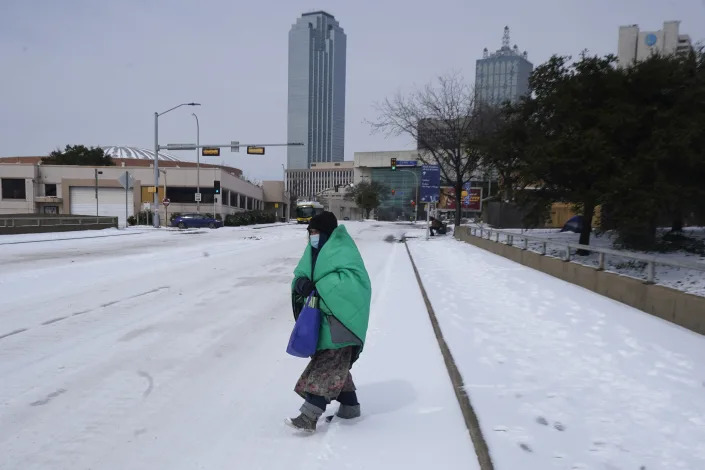
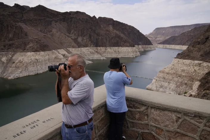
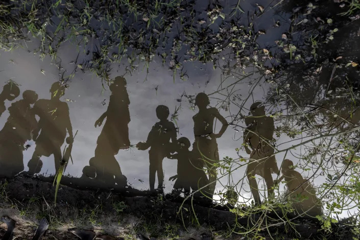
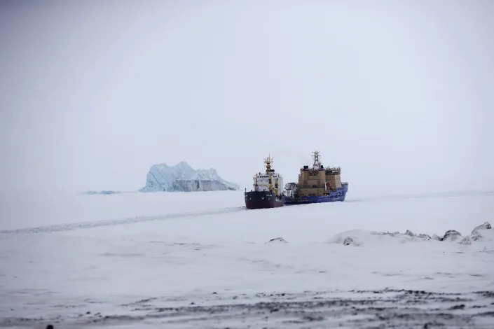
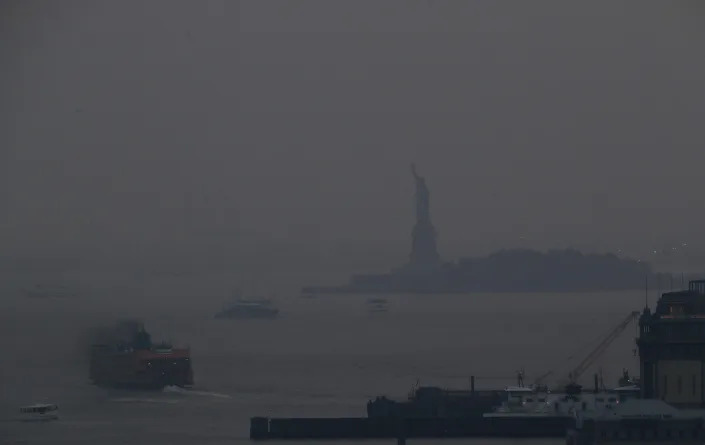
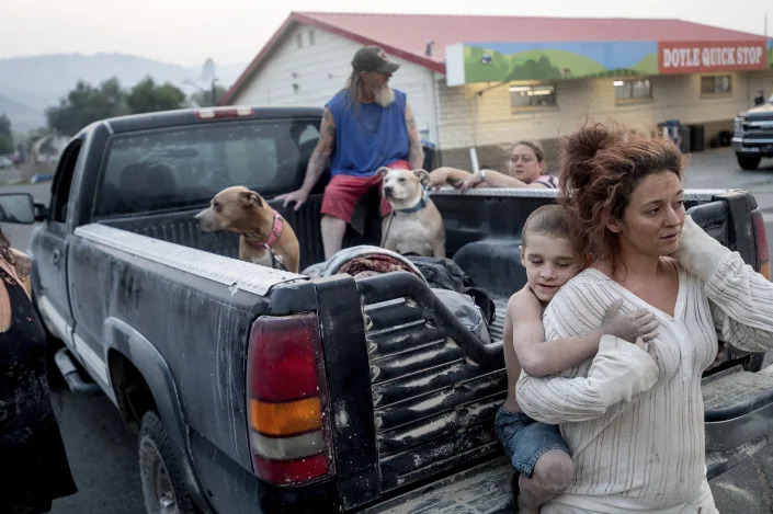
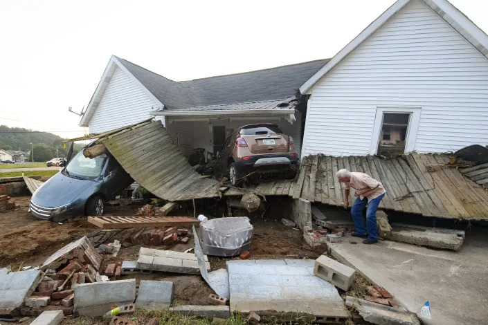
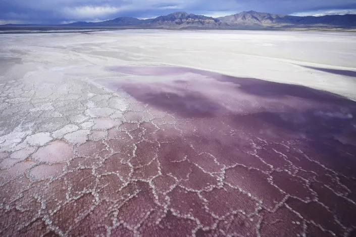
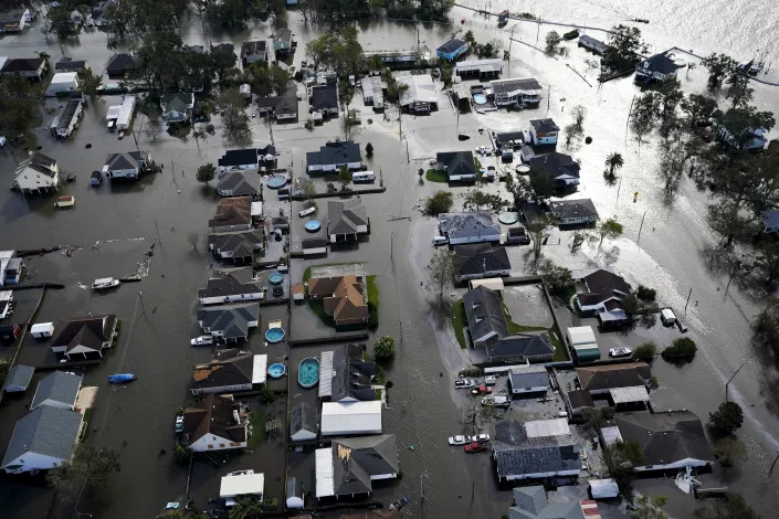
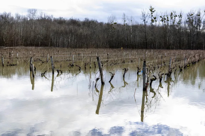
A train passes a railroad crossing surrounded by floodwaters from rain and melting snow in Nidderau near Frankfurt, Germany, Wednesday, Feb. 3, 2021. (AP Photo/Michael Probst)A man watches as wildfires approach Kochyli beach near Limni village on the island of Evia, about north of Athens, Greece on Aug. 6, 2021. (AP Photo/Thodoris Nikolaou)A woman wrapped in a blanket crosses the street near downtown Dallas, Tuesday, Feb. 16, 2021. Temperatures dropped into the single digits as snow shut down air travel and grocery stores. (AP Photo/LM Otero)People take pictures of Lake Mead near Hoover Dam at the Lake Mead National Recreation Area, Friday, Aug. 13, 2021, in Arizona. The bathtub ring of light minerals shows the high water mark of the reservoir which has fallen to record lows. (AP Photo/John Locher)Children standing on a small mud dyke are reflected in the stagnant water, in Langic, Northern Bahr el Ghazal State, South Sudan, Wednesday, Oct. 20, 2021. This is the third straight year of extreme flooding in South Sudan, further imperiling livelihoods in the world’s youngest country. A five-year civil war, hunger and corruption have all challenged the nation. Now climate change, which the United Nations has blamed on the flooding, is impossible to ignore. (AP Photo/Adrienne Surprenant)An Icebreaker making the path for a cargo ship with an iceberg in the background near a port on the Alexandra Land island near Nagurskoye, Russia, Monday, May 17, 2021. (AP Photo/Alexander Zemlianichenko)People walk on salt flats in Badwater Basin, Sunday, July 11, 2021, in Death Valley National Park, Calif. Death Valley, in southeastern California’s Mojave Desert, reached 128 degrees Fahrenheit (53 Celsius) a day earlier, according to the National Weather Service’s reading at Furnace Creek. The shockingly high temperature was actually lower than the previous day, when the location reached 130 F (54 C). (AP Photo/John Locher)People ride a canoe through “sea snot” in Turkey’s Marmara Sea by the Caddebostan shore, on the Asian side of Istanbul, Tuesday, June 8, 2021. Sea snot is a huge mass of marine mucilage, a thick, slimy substance made up of compounds released by marine organisms. (AP Photo/Kemal Aslan)The Staten Island Ferry departs from the Manhattan terminal through a haze of smoke with the Statue of Liberty barely visible, Tuesday, July 20, 2021, in New York. Wildfires in the American West, including one in Oregon created hazy skies as far away as New York. (AP Photo/Julie Jacobson)Destiney Barnard holds Raymond William Goetchius while stranded at a gas station near the Dixie Fire on Tuesday, Aug. 17, 2021, in Doyle, Calif. Barnard was helping Goetchius and his family evacuate from Susanville when her car broke down. (AP Photo/Noah Berger)Birds fly over a man taking photos of the exposed riverbed of the Old Parana River, a tributary of the Parana River during a drought in Rosario, Argentina, Thursday, July 29, 2021. Parana River Basin and its related aquifers provide potable water to close to 40 million people in South America, and according to environmentalists the falling water levels of the river are due to climate change, diminishing rainfall, deforestation and the advance of agriculture. (AP Photo/Victor Caivano)The Dixie Fire burns down a hillside towards Diamond Mountain Rd. near Taylorsville in Plumas County, Calif., on Friday, Aug. 13, 2021. (AP Photo/Noah Berger)Ernest Hollis looks for items at his granddaughter’s house that was devastated by floodwaters, Monday, Aug. 23, 2021, in Waverly, Tenn. Heavy rains caused flooding in Middle Tennessee days ago and have resulted in multiple deaths, and missing people as homes and rural roads were also washed away. (AP Photo/John Amis)Bare trees stand in a destroyed forest near the Kemerkoy Power Plant, a coal-fueled power plant, in Milas, Mugla in southwest Turkey, Thursday, Aug. 5, 2021. A wildfire reached the compound of a coal-fueled power plant in southwest Turkey and forced evacuations by boats and cars. (AP Photo)Keeping cool in record setting temperatures, Beau Jess and daughter River, 3, reach for falling water as they play at the Splash Pad in Haller Park on Monday, June 28, 2021, in Arlington, Wash. (Andy Bronson/The Herald via AP)A house is surrounded by flood waters in Londonderry on the outskirts of Sydney, Australia, Tuesday, March 23, 2021. Hundreds of people have been rescued from floodwaters that have isolated dozens of towns in Australia’s most populous state of New South Wales and forced thousands to evacuate their homes as record rain continues to inundate the countries east coast. (AP Photo/Mark Baker)A woman throws away rubbish in the center of Bad Neuenahr-Ahrweiler, Germany, Monday July 19, 2021. More than 180 people died when heavy rainfall turned tiny streams into raging torrents across parts of western Germany and Belgium. (AP Photo/Bram Janssen)Boats languish over the last pools of water available on the Payagua stream that reaches the Paraguay river amid a historic drought that is affecting its levels, in Chaco-i, Paraguay, Monday, Sept. 20, 2021. (AP Photo/Jorge Saenz)Ice coats a cave in the Eagle Glacier on Sunday, Feb. 14, 2021, in Juneau, Alaska. The glacier is remote, and one way to access it involves a 5.5 mile hike on a rugged trail to a public use cabin followed by lake crossings. (AP Photo/Becky Bohrer)Residents walk along a dirt road in the Urus del Lago Poopo indigenous community, which sits along the salt-crusted former shoreline of Lake Poopo, in Punaca, Bolivia, Monday, May 24, 2021. Bolivia’s second-largest lake dried up about five years ago, victim of shrinking glaciers, water diversions for farming and contamination. (AP Photo/Juan Karita)A man carries goods on his bicycle as he walks out of the Yubei Agricultural and Aquatic Products World in Xinxiang in central China’s Henan Province on July 26, 2021. (AP Photo/Dake Kang)Pink water washes over a salt crust on May 4, 2021, along the receding edge of the Great Salt Lake. The lake has been shrinking for years, and a drought gripping the American West could make this year the worst yet. (AP Photo/Rick Bowmer)A woman is carried through a flooded street in Angleur, Province of Liege, Belgium, July 16, 2021. Severe flooding in Germany and Belgium has turned streams and streets into raging torrents that have swept away cars and caused houses to collapse. (AP Photo/Valentin Bianchi)Homes are flooded in the aftermath of Hurricane Ida, Monday, Aug. 30, 2021, in Jean Lafitte, La. (AP Photo/David J. Phillip)A kayaker fishes in Lake Oroville as water levels remain low due to continuing drought conditions in Oroville, Calif., Aug. 22, 2021. (AP Photo/Ethan Swope)A child cools off with the water to the fountain during a heatwave in Pamplona, northern Spain, Aug. 13, 2021. Stifling heat gripped much of Spain and Southern Europe. (AP Photo/Alvaro Barrientos)Floodwaters submerge vineyards near Cognac, southwestern France, Sunday, Feb. 7, 2021. Scientists say damaging frost that caused significant economic loss to France’s central wine-growing region this year was made more likely by climate change. (AP Photo/Yohan Bonnet)People travel through a torrential downpour caused from the remnants of Hurricane Ida, near Columbus Circle on Sept. 1, 2021. As weather becomes more extreme and unpredictable caused by climate change, transit officials say that more needs to be done to prepare the East Coast’s vital transit systems. (AP Photo/Craig Ruttle)
Fires raged. Rivers flooded. Ice melted. Droughts baked. Storms brewed. Temperatures soared. And people died.
Climate change in 2021 reshaped life on planet Earth through extreme weather.
World leaders are gathering in Scotland to try to accelerate the fight to curb climate change. So far, it’s not working, as the world keeps getting hotter and its weather more extreme, scientists and government officials say. They don’t have to point far back in time or far off for examples.
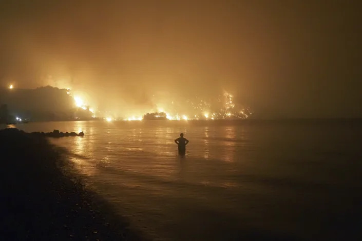
There have been deadly floods in Belgium, Germany, China and Tennessee. Fire blazed in parts of the U.S. West, Greece and even the Arctic.
Heat waves proved deadly and unprecedented, pushing temperatures in the Northwest and even reaching 116 degrees Fahrenheit (47 degrees Celsius) in Portland, Oregon, a city known for its mild climate. Hurricane Ida paralyzed New York City with record-breaking, deadly rain.
“These events would have been impossible without human-caused climate change,” U.N. Secretary-General Antonio Guterres said.
In just the United States, there have been 18 weather or climate disasters this year with losses exceeding $1 billion a year, according to the National Oceanic and Atmospheric Administration. Those 18 disasters caused 538 deaths and nearly $105 billion in damage. In the 1980s, the average year only saw three such disasters.
A report from AIR Worldwide, a global risk modeling firm, estimates that now each year extreme weather is costing $320 billion around the world, with only about one-third of it insured.
“We now have five times the number of recorded weather disasters than we had in 1970, and they are seven times more costly,” Guterres said, speaking about global totals. “Even the most developed countries have become vulnerable.”
The Tarbaby’s Blog was hacked about 6 weeks ago. Our webhost IONOS has been trying to correct the problems, but have still been unable to fix the posting issues, so please be patient. I’m way behind in posting and will try to catch up in the next few weeks.
Whether posting and debating about the coronavirus and public health, the environment and the catastrophic consequences of global warming and climate change, the threats to America’s Democratic institutions, politics, voter suppression and intimidation, Veterans advocacy, fair labor practices or a long list of vital social and economic issues, truth tellers become a target for those who would like to silence public debate and speaking truth to power. We will not be silenced. Please stay tuned.
“The 360” shows you diverse perspectives on the day’s top stories and debates. What is COP26 and how will it affect the future of climate change? Glasgow, Scotland called COP26.
What’s happening
The Biden administration on Wednesday released a report that predicts climate change will force “tens of millions” of people around the world to be displaced in the next few decades. The report echoes the findings of a number of previous studies that suggest worsening climate impacts — sudden disasters like fires and storms, plus more gradual problems like rising seas and drought — could displace as many as 200 million people before 2050.
Climate change affects the whole world, but the citizens of certain low-income countries everywhere from Central America to sub-Saharan Africa are especially vulnerable to climate-related displacement. Beyond the harm of millions of people being forced from their homes, climate migration could threaten the stability of resource-strained countries and increase the risk of conflict between nations, according to a separate national security assessment released this week.
While estimates paint a particularly dire picture of the future, some of the effects of climate displacement are already being felt around the world. The United Nations estimates that an average of 21.5 million people worldwide are displaced by sudden disasters every year. Droughts and storms in Central America are believed to be one of many reasons for an influx of migrants heading to the U.S.-Mexico border in recent years. The Syrian civil war, which has created a devastating humanitarian crisis and displaced more than 13 million people over the past 10 years, has been partially attributed to a drought that forced rural farmers to flood into urban areas.
Why there’s debate
As worrying as some forecasts of the future are, a range of experts say that with the right preparation and investment, climate migration can be managed to limit suffering and prevent countries from falling into chaos.
A key step, most experts argue, is for rich countries like the U.S. to do everything within their power to prevent people from being forced to migrate in the first place. That starts with limiting greenhouse gas emissions that cause global warming. Doing so would reduce the potential severity of storms, droughts and other factors that drive people from their homes. Rich countries also need to offer aid to poorer countries to adapt to climate change — for example, helping low-income countries build infrastructure to handle higher sea levels and stronger storm surges and dealing with major population shifts within their borders, since most climate migrants relocate to new areas of their home countries.
Many also argue the U.S. will need to update its immigration system to prepare for the unique challenges of managing climate migration. Some immigrant rights activists say climate displacement should be added to the list of reasons a person can qualify for refugee status. That’s controversial on both the left and the right. There’s broad agreement among experts, though, that a more permissive immigration system — with less focus on aggressive border enforcement and more pathways to enter the country legally — could not only prevent unnecessary suffering, but also create benefits for the U.S. economy.
What’s next
Climate migration is expected to be one of many important issues discussed by world leaders at the upcoming U.N. Climate Change Conference in Glasgow, Scotland. Representatives from nearly 200 countries will meet over the course of two weeks in hopes of reaching an agreement on an emissions reduction strategy to avert the worst potential impacts of climate change.
Perspectives
Strict immigration enforcement isn’t the answer
“States that have grown addicted and accustomed to solving problems with walls and weapons are acting to news of climate-linked mobility by trying to repel people, hoping to insulate themselves. … Not only will this cause ever more human suffering, it will fail on its own terms.” — Todd Miller, Independent
Fear-inducing rhetoric about the threat of climate migration must end
“When most people think of ‘climate’ and ‘immigration,’ they think at the global scale — which can be scary. The idea that a changing, increasingly inhospitable climate will drive mass migration is frightening. … But migration is, and has always been, a form of adaptation — and it can be a major benefit to receiving communities.” — Claire Elise Thompson, Grist
Immigration laws need to be updated to recognize climate displacement
“A lack of lawful migration opportunities forces many of those moving for climate-related reasons to do so without authorisation and at risk of exploitation and abuse. But solutions are within our grasp.” — Tamara Wood and Edwin Abuya, Thomson Reuters Foundation
With the right planning, climate migrants can help the U.S. thrive
“Migration can bring great opportunity not just to migrants but also to the places they go. As the United States and other parts of the global North face a demographic decline, for instance, an injection of new people into an aging work force could be to everyone’s benefit.” — Abrahm Lustgarten, New York Times
The U.S. must provide extensive support for vulnerable countries
“The best deterrent to migration is hope. We must provide the leadership that allows the people
in our own hemisphere the chance to survive and prosper at home.” — Cecilia Muñoz, The Hill
Climate shouldn’t be treated as the only reason people leave their homes
“In general, illegal border crossings can be traced to any number of factors: job opportunities, drug trafficking, political shifts, and, yes, climate change. There’s nothing wrong with bringing attention to these issues by examining them in print. But to solve a problem, you have to properly define it first. We can and should address the border crisis and climate change at the same time. But conflating the two only makes that task more difficult.” — Sean-Michael Pigeon, National Review
Limiting climate change will reduce the need for climate migration in the first place
“The most useful thing that the developed countries of the West can do to help endangered societies elsewhere is to rapidly limit our own carbon emissions — for if we fail to do so and temperatures rise uncontrollably, then weak states around the world will assuredly fail.” — Anatol Lieven, Foreign Policy
We should start helping people relocate before their situation becomes desperate
“Real change — like relocating entire neighborhoods and communities out of harm’s way — would be far better handled not in times of crisis, when the displaced must weigh complex decisions in the midst of chaos and loss, but before a crisis hits.” — Alexandra Tempus, New York Times
Climate migrants can be an enormous asset if given the right opportunities
“The easier we make it for the young to move to places where they can contribute productively, such as by building more sustainable housing and irrigation systems, the better our odds during the turbulent decades ahead.” — Parag Khanna, National Geographic
Is there a topic you’d like to see covered in “The 360”? Send your suggestions to the360@yahoonews.com.
Photo illustration: Yahoo News; photos: Joe Raedle/Getty Images

 German farmers Tim Nandelstädt (centre) and Torben Reelfs (right) push ahead with their crop planting in Ukraine despite Russia’s invasion (AFP/Tim NANDELSTAEDT)
 War has come to Ukraine but German farmers Torben Reelfs and Tim Nandelstaedt are planting the first sugar beets of the season on their plot of land in western Ukraine (AFP/Tim NANDELSTAEDT)