Natural disasters, boosted by climate change, displaced millions of people in U.S. in 2022
Lucas Thompson – February 12, 2023
Ricardo Arduengo
Natural disasters forced an estimated 3.4 million people in the U.S. to leave their homes in 2022, according to Census Bureau data collected earlier this year, underscoring how climate-related weather events are already changing American communities.
The overwhelming majority of these people were uprooted by hurricanes, followed by floods, then fires and tornados. Nearly 40% returned to their homes within a week. Nearly 16% have not returned home (and may never do so), and 12% were evacuated for more than six months.
The Census Bureau count is based on 68,504 responses it received as part of the Household Pulse Survey conducted Jan. 4-Jan. 16. The data collection is one of the few federal efforts to track displaced people, starting only in 2020. The bureau does note that the data is “experimental,” and is extrapolated based on its sample data.
“These numbers are very distressing,” said Michael Gerrard, director of the Sabin Center for Climate Change Law at Columbia University, who was not involved in the data collection. “These numbers are what one would expect to find in a developing country. It’s appalling to see them in the United States. … They’re only going to get worse in the years to come because climate change is making extreme weather events more frequent and more severe.”
Some states experienced far more of an impact than others. Florida had more than 888,000 people displaced. Louisiana had more than 368,000 displaced.
The U.S. was hit by a series of major disasters in 2022. The National Oceanic and Atmospheric Administration said that 18 extreme weather events had each caused at least $1 billion in damage. Climate experts have warned for years to expect more intense weather disasters as global temperatures rise.
The Census Bureau estimate, almost 1.4% of the U.S. adult population, is higher than other estimates. Data from the Internal Displacement Monitoring Center, part of the humanitarian organization The Norwegian Refugee Council, previously estimated that disasters displaced an average of 800,000 U.S. residents a year from 2008 through 2021.
“The United States is not in the least prepared for this,” Garrard said. “Our settlement patterns have not reflected the emerging risks of climate change to the habitability of some parts of the country.”
The data showed that the more than half a million people who never returned home experienced multiple hardships, including lack of housing, food, water, sanitation and child care.
“These are all things that we take for granted in a modern society,” Gerrard added. “Its absence is deeply disruptive to physical and emotional health as well as to child development.”
The data also showed disparities between people of different economic status, race and identities. Those earning less than $25,000 a year had the highest evacuation rate of any economic group, and Black and Hispanic residents had slightly higher evacuation rates than white residents.
According to the data, adults who identify as LGBTQ were disproportionately affected — 4% of LGBTQIA+ adults had to leave their homes compared with 1.2% of straight, cisgender people.
“It’s important to note that a lot of these individuals that are LGBTQ are often also considered to be socially vulnerable, and really putting a strong intersectional lens to disaster response preparedness and recovery,” said Michael Méndez, a professor of environmental policy and planning at the University of California, Irvine.
“Much of the LGBT community that’s vulnerable, and most socially vulnerable to disasters, are those that are African American, transgender and low income,” he said. “Oftentimes, that’s why they’re rendered invisible in the context of disaster policy and planning and preparedness. People write them off as not needing to provide extra resources for this community.”
Imperial Valley has made enough sacrifices already in the water rights war
Craig William Morgan – February 12, 2023
There is an old saying in the water world that it is better to be upstream with a shovel than downstream with a law book, which is the position California finds itself in as it stands apart from its neighbors on the Colorado River in negotiations over the use of the river’s water.
On Jan. 31, representatives for the six other basin states submitted a proposal to the Bureau of Reclamation describing the measures by which the supply deficit on the Colorado River should be closed in the near term. Not surprisingly, the other basin states have asked that California reduce its water use beyond that which the state had previously proposed last fall. California was right to decline its neighbors’ new proposal notwithstanding its position on the river.
As many readers know, California water users have priority rights to Colorado River water that allow them to receive water first in times of drought. These rights are derived under the appropriative rights doctrine known as “first in time, first in right” that has been a mainstay of western water law for more than a century and a half. Those without such rights are legally bound to reduce their use.
Not surprisingly, those without such rights have developed a new theory of law that effectively says the priority system of water allocation is no longer applicable because of climate change.
The new buzzword describing this change is “aridification.” The terms “shortage” and “drought” that have historically been used they claim are no longer relevant to describing water conditions. The reason for this change in nomenclature is because existing law is very clear that water is apportioned based on priority during times of shortage and drought.
They argue that aridification is somehow different. It is not.
If state and federal courts were to interpret a distinction in such terms, water law would not only be upended along the Colorado River system, but indeed across the entire United States.
The Upper Basin states of Colorado, Wyoming, Utah and New Mexico have joined the chorus of Nevada and Arizona in arguing that aridification demands the priority system be ignored. They also argue that the requirement under the 1922 Colorado River Compact among the basin states guaranteeing a fixed quantity of water be delivered to the Lower Basin states should be ignored on the same grounds. Their fears are that such a requirement will limit their existing and proposed future diversions of Colorado River water. To date, these states’ diversions have been well below their junior allotment. The imbalance on the Colorado River they argue is a Lower Basin concern, not an Upper Basin concern.
But such a position is inconsistent and self-serving. If in fact, aridification demanded that the priority system be ignored along the river, wouldn’t it make sense that all water users within the Colorado River basin take a reduction, not just those in the Lower Basin as Upper Basin users have proposed? It is noteworthy that Upper Basin states thus far have not meaningfully participated in reducing demands on the Colorado River. Yet they should.
Why haven’t Arizona and Nevada looked harder at the Upper Basin states to reduce their water use to balance demands instead of focusing on California? Perhaps they are hoping that California’s Imperial Valley will once again come to the rescue of the river’s water users as was done in 2003 when the Imperial Irrigation District signed the Quantification Settlement Agreement (QSA) and reduced its water use by more than 15 %. As the river’s biggest water user (and least politically potent), surely, they must have more water to spare.
The residents of Imperial Valley are right to be concerned about the future of their community. In 2003, the Imperial Irrigation District, despite holding senior water rights to the river for the benefit of its farming community, succumbed to the political pressures within California and from other basin states to reduce their demands on the Colorado River.
The argument made at the time by the river’s other water users was that the district was wasting water. However, the fact of the matter was that the district’s water use was no different than that of other irrigation districts across the west. The QSA water transfers have created significant hardships on the local communities and an ecological nightmare for the Salton Sea.
As the basin states and federal government move forward in crafting solutions to the water shortage problem on the Colorado River, they must consider the sacrifices that have already been made by those living in Imperial Valley: Sacrifices that have been made by those holding senior water rights. They must also consider the damage that would be done to the legal structure governing water use across the west if the priority system is to be ignored.
Craig William Morgan is a water resources engineer who served as consultant to farmers opposing the QSA. He is the author of the recently published book about the QSA and the fight for Imperial Valley’s water called “The Morality of Deceit.”
Amsterdam plans to ban weed from Red Light District streets
Hannah Sampson – February 10, 2023
Amsterdam, Netherlands – October 1, 2012: Amsterdam’s red-light district at night. There are about three hundred cabins rented by prostitutes in the area. (sborisov via Getty Images)
In their latest effort to rein in carousing visitors, Amsterdam officials announced plans this week to tamp down disruptive behavior in the city’s Red Light District, including barring pot-smoking on the streets, reducing hours for restaurants and brothels, and tightening some alcohol restrictions.
The rules are meant to ease the impact of hordes of sometimes-rowdy tourists on people who live in the area. An announcement from the city council referenced an alcohol- and drug-fueled atmosphere at night that makes the neighborhood unsafe and prevents residents from sleeping.
Officials are taking public comments on many of the proposed measures for the next four weeks before finalizing amendments to municipal bylaws.
Under the measures announced Thursday, the smoking ban would go into effect in mid-May. The city could take more action if the ban doesn’t go far enough to reduce nuisance behavior.
Also under consideration: banning to-go sales of drugs at coffee shops at certain times and potentially restricting smoking on cafe terraces.
The Netherlands has a tolerance policy for weed, meaning people will not be prosecuted for buying up to five grams of cannabis, which is classified as a “soft drug” and sold in coffee shops. Only visitors 18 and older can enter cannabis cafes, which are not allowed to sell alcohol. While weed can be consumed in coffee shops, most clubs or bars do not allow people to smoke pot on-site.
The city issues permits for brothels and sex clubs to operate. Under rules that had already been decided, brothels will only be able to stay open until 3 a.m., not the 6 a.m. closing time in place now. Restaurants and sex establishments with catering licenses will have to close at 2 a.m. on Fridays and Saturdays, rather than 3 or 4 a.m.
No new visitors would be allowed into businesses with a catering license after 1 a.m., the English-language publication NL Times reported. The time changes would go into effect April 1, the publication said.
Officials also want to close terraces at 1 a.m. in the summer, a change from the previous closing time of 2 a.m.
Alcohol sales at stores and cafeterias in the district will continue to be blocked starting at 4 p.m. from Thursday through Sunday. The city says alcohol displays must also be removed from the shops or hidden from view. Visitors are already not allowed to drink on the streets.
Amsterdam has tried for years to address overtourism concerns, restricting some tours of the historic Red Light District before the pandemic and voting to move sex workers to an erotic center outside of the district in 2021. According to a November story in the Guardian, however, residents of the proposed neighborhoods for relocation don’t want the businesses – and the workers also don’t want to move.
Late last year, authorities said they planned to take steps to combat tourism problems, including limiting river cruises, curbing rowdy bachelor parties, cracking down on organized pub crawls and taking other measures. Part of the plan included some of the rules announced this week, such as reducing hours for sex businesses and catering establishments and banning smoking in some parts of the city.
A campaign is expected to start this year discouraging global visitors who want to party hard in the city.
“Amsterdammers live in every neighborhood, including the Red Light District and Leidseplein,” the official visitor information site I amsterdam says. “Limit noise and drunkenness, clean up your mess and don’t pee in the canals. Keep in mind the locals and they will welcome you with open arms.”
The Colorado River should really be named the California River
Joe Mathews – February 9, 2023
Why do we still call it the Colorado?
Sure, the river begins in the Colorado Rockies. But in law and practice, the waterway making headlines is clearly the California River. And the first provision of any deal to save the river should rename it accordingly.
This condition wouldn’t be about Golden State pride. Instead, a name change would more accurately reflect the imperial role California plays out in the movement of water, people and power in the American West.
Right now, the Grand Canyon-sized divide over how to reduce the amount of water drawn from the rapidly diminishing river is being portrayed as a dispute between states. On one side, six states that rely on California-nee-Colorado water — Arizona, Colorado, Nevada, New Mexico, Utah and Wyoming — have come together to demand cuts in water use that would fall heaviest on California.
In response, California water officials have produced a plan emphasizing how our state’s rights to the water are more senior than those of our Southwest neighbors. Their newly released plan would cut less from California’s take, and more from Arizona and Nevada. In the Wild West of Water, this argument — We stole it first! We stole it fair and square! — is a strong legal position.
But such descriptions of the fight fail to capture the true dynamics of the situation — that California is less a state than an empire, and the six states challenging it over water are California colonies. California is by far the richest and most dynamic area in this half of North America. California has more residents and a bigger economy than all the other western states of the U.S. put together.
In recent generations, California, like other great empires through history, has grown so much that it has exported people, money, and culture to nearby territories. California’s investment has helped make the intermountain West the nation’s fastest-growing region.
Many of the greater West are native Californians, or immigrants who came through the Golden State. Nevada is the most Californian state; with nearly as many California natives (20%) as Nevada natives (25%), and more than 90% of its population living within 50 miles of the California border. But Californians have also provided sizable percentages of new residents to Utah, Colorado, and Arizona, where one out of every 10 residents was born here.
Are these transplanted Californians grateful for our largesse? Of course not. Colonists don’t freely thank their emperors, which is why every so often, the L.A. Times or New York Times interviews some real estate agent in Phoenix or Las Vegas or Denver, who whines about how the California ex-pats are driving up housing prices.
Oh, you denizens of western deserts and mountains, please forgive us Californians for making you wealthier!
With water, our successful colonization policies create headaches for us. We seized the water of the Western wilderness to build the world’s fourth-largest economy. But that wilderness is now full of former Californians and their communities, which now mercilessly seek a bigger share of the water.
Alas, the patently strong argument that Californians should keep the water because we do more things with it is not politically palatable in our colonies. Nor should we expect the president, from the tiny corporate tax haven of Delaware, to choose the needs of our great empire over the demands of those swing state deserts, Arizona and Nevada.
Instead, we have little choice but to behave like wise empires, and do for our colonies what they won’t do for themselves. “The price of greatness,” Winston Churchill observed, “is responsibility.”
California must develop and finance a water plan not just for itself but for the West — with more water recycling, more capture of stormwater, more desalination, and more water for everyone — so that our empire is no longer dependent on that workhorse river.
In return, everyone should start calling our river by its proper name.
Climate change contributing to spread of antibiotic-resistant ‘superbugs’: UN report
Zack Budryk – February 7, 2023
Climate change is heightening the risk posed by antibiotic-resistant viruses, according to research published Tuesday by the United Nations Environment Program.
The report found so-called superbugs have been exacerbated by climate change due to increased bacterial growth caused by warmer temperatures and pollutants that have increased the spread of antibiotic-resistance genes.
The analysis notes that overuse of antimicrobials and pollutants can spread resistance, while contact with resistant microorganisms can create resistance in bacteria already present in air, water and soil. Pollution associated with wastewater, particularly from hospitals, is a major factor, as well as runoff from pharmaceutical production and agriculture, according to the report.
The risk is particularly great for historically polluted waterways, which are more likely to provide shelter for microorganisms that foster antibiotic resistance. A combination of increased pollution and decreased resources for pollutant management has made the problem worse in combination with resistance in health care and agriculture settings.
Meanwhile, 2021 research published in the journal Sci Total Environ suggests urban flooding is also increasing the threat from antibiotic resistance due to disruptions of soil, with the risk possibly lingering for up to five months after major floods or hurricanes.
“While the relationship between environmental pollution and AMR [antimicrobial resistance] and the reservoir of resistance genes in the environment has been established, the significance and its contribution to AMR globally is still unclear,” researchers wrote. “Even so, there is enough knowledge to implement measures to reduce the factors that influence AMR from an environmental perspective; this will also address the triple planetary crisis by addressing sources, sinks and waste.”
The report calls for stronger regulatory frameworks to address the spread of AMR, as well as increased incorporation of environmental factors into National Action Plans for antimicrobial resistance and international standards for signs of antimicrobial resistance.
Policymakers should also develop stronger water sanitation standards, U.N. Environment Program researchers wrote.
Worried about having a gas stove? Here’s how to limit risks.
Allyson Chiu, The Washington Post – February 7, 2023
Note: This article has been updated to include additional safety information about using induction hot plates.
The raging gas stove debate might have you reassessing how you cook. But replacing a gas stove with an induction stove – a commonly recommended alternative – isn’t always feasible.
Renters are often limited in what they can do. For homeowners, swapping out a gas range can be expensive and complicated, especially if it involves electrical updates.
Still, even if you cannot get rid of your gas stove, you can take several steps to help protect your health and the planet:
Get reacquainted with your other appliances
A whole world of versatile and convenient cooking devices exist outside of your gas stove.
“There’s a lot of appliances available that can address different things you might need to do in the kitchen, and so you can go a long way toward electrifying all of your cooking,” said Talor Gruenwald, a research associate at Rewiring America, a nonprofit group focused on electrification.
Beyond the trusty microwave, you might have one or more of the following appliances taking up space in your kitchen: toaster oven, air fryer, Instant Pot (or some other multicooker), or an electric kettle or hot water heater.
Using them more, particularly for smaller meals, can help reduce the amount of pollutants, such as nitrogen dioxide, released into your home when you turn on your gas burners. Research has linked nitrogen dioxide to increased risk of childhood asthma and worsening asthma symptoms. A recent peer-reviewed study estimated that about 12.7 percent of childhood asthma cases nationwide could be attributed to gas cooking.
Here are some creative ways you can use your appliances:
– Microwaves: They can do much more than just zap cold leftovers. You can bake (remember mug cakes?), steam vegetables and in some situations even toast, fry or caramelize food. For more detailed tips on how you can make the most out of your microwave, read this article from my colleague Becky Krystal.
– Toaster ovens: Reheating leftovers, such as pizza or fries, that you don’t want to eat soggy? Broiling seafood, vegetables or a cheesy open-face sandwich? Baking savory casseroles or sweet desserts? Most modern toaster oven models can likely do it all. Read more here.
– Air fryers: You can make entire balanced and healthy meals in an air fryer in less than 30 minutes with inexpensive ingredients and minimal cleanup afterward, as my colleague Anahad O’Connor writes. You can also bake in air fryers.
– Instant Pots or multicookers: Aside from its handy pressure cooker feature, they can serve as effective steamers and slow cookers, and are even “equipped with a sauté or sear function, meaning you can use them as you would a pot or skillet on a traditional stovetop,” Krystal writes.
Pay attention to ventilation
If you do need to use your gas stove or oven, it can help to turn on your range hood while cooking, Gruenwald said.
Brady Seals, a manager in the carbon-free buildings program at RMI, a clean-energy think tank, recommends using the rear burners on your stovetop where the range hood can be more effective.
If your hood isn’t vented outside or you don’t have one, you should open your windows, experts said.
“You just want to try to move air and bring in clean air,” Seals said, noting that people can try turning on a bathroom fan. “Even opening a window for five minutes can sometimes be helpful in removing some of the pollutants.”
And don’t forget to maintain your gas stove. Some research has found that unused stoves can still leak methane, a powerful greenhouse gas, as well as other hazardous air pollutants, such as benzene. If you’re concerned about leaks, consider having a professional examine the fittings on your stove, Gruenwald said.
Experiment with induction
You can also buy a low-cost induction hot plate that plugs in to a regular outlet. Models are available with single or double burners.
What’s more, experts say you can turn your gas stove into a makeshift induction cooktop by first closing the gas valve behind the stove and then placing an electric hot plate on top. Make sure to double check that no gas is coming out of your burners and that all the knobs are also turned off. It may be helpful to use a butcher block or other sturdy flat surface to provide a firm footing for the hot plate.
“If you are curious about induction but aren’t able to make the switch because you’re a renter or other reasons, it’s a good way to try out the speed and see all the other benefits,” Seals said.
Death toll climbs as 7.8 magnitude earthquake rocks Turkey and Syria: Here’s everything we know
Photos show the devastation and desperate search for survivors after an earthquake hit the border of Turkey and Syria.
Dylan Stableford and Yahoo News Photo Staff – February 6, 2023
Rescuers carry out a girl from a collapsed building following an earthquake in Diyarbakir, Turkey February 6, 2023. (Sertac Kayar/Reuters)
At least 2,300 people were killed after a 7.8 magnitude pre-dawn earthquake rocked the border of Turkey and Syria early Monday, toppling thousands of buildings and leaving hundreds of people trapped under rubble.
The quake, which was centered on Turkey’s southeastern province of Kahramanmaras, could be felt as far away as Cairo and Beirut, as powerful aftershocks continued to rattle the region.
Here’s everything we know about the earthquake and its aftermath.
This aerial view shows residents searching for victims and survivors amidst the rubble of collapsed buildings following an earthquake in the village of Besnia near the twon of Harim, in Syria’s rebel-held northwestern Idlib province on the border with Turkey, on February 6, 2022. (Omar Haj Kadour/AFP via Getty Images)
The U.S. Geological Survey measured the 7.8 magnitude quake at a depth of 17.9 km, or about 11 miles, at 4:17 a.m. local time.
“On both sides of the border, residents jolted out of sleep by the pre-dawn quake rushed outside on a cold, rainy and snowy night. Buildings were reduced to piles of pancaked floors,” the news service reported. “Rescue workers and residents in multiple cities searched for survivors, working through tangles of metal and concrete. A hospital in Turkey collapsed, and patients, including newborns, were evacuated from facilities in Syria.”
An infographic titled “Impact area of earthquakes in Turkey” created in Ankara, Turkiye on February 06, 2023. (Yasin Demirci/Anadolu Agency via Getty Images)
Dozens of aftershocks followed. Hours later, a 7.5 magnitude quake struck more than 60 miles away. An official from Turkey’s disaster management agency said it was a new earthquake, not an aftershock, the AP said.
Death toll climbs
In Turkey, officials said the death toll had risen to almost 1,500, with at least 8,500 injured.
In Syria, the death toll in government-held areas was at least 430 with more than 1,200 injured, the Syrian Health Ministry reported. In rebel-held areas, more than 380 people were killed, according to the Syrian Civil Defense unit, also known as the White Helmets.
Search and rescue operations continue after 7.7 magnitude earthquake hits Elazig, Turkiye on February 06, 2023. (Ismail Sen/Anadolu Agency via Getty Images)
Turkish President Recep Tayyip Erdogan warned that the death toll will undoubtedly rise.
“Because the debris removal efforts are continuing in many buildings in the earthquake zone, we do not know how high the number of dead and injured will rise,” Erdogan said. “Hopefully, we will leave these disastrous days behind us in unity and solidarity as a country and a nation.”
Winter weather complicates recovery efforts
Bitterly cold temperatures and worsening conditions were complicating the search and rescue efforts, Reuters reported.
Civil defense workers and security forces search through the wreckage of collapsed buildings in Hama, Syria, Monday, Feb. 6, 2023. (SANA via AP)
“Temperatures in some areas were expected to fall to near freezing overnight, worsening conditions for people trapped under rubble or left homeless,” the news service said. “Rain was falling on Monday after snowstorms swept the country at the weekend.”
What’s more, “poor internet connections and damaged roads between some of the worst-hit cities in Turkey’s south, homes to millions of people, hindered efforts to assess and address the impact.”
Quake struck war-torn region
The earthquake struck a region that has been battered on both sides of the border by more than a decade of civil war in Syria.
Rescue teams search for victims in the rubble following an earthquake in northwestern Syrian Idlib in the rebel-held part of Idlib province, on February 6, 2023. (Syria Civil Defense/UPI/Shutterstock)
“On the Syrian side, the region is divided between government-held territory and the country’s last opposition-held enclave, which is surrounded by Russian-backed government forces. Turkey is home to millions of refugees from that conflict. About 4 million people live in the opposition-held regions in Syria, many of them displaced from other parts of the country by the fighting. Many of the residential buildings were already unsafe because of bombardments.”
Mehmet Emin Ataoglu rescued under the rubble of 6-storey-building after 7.7 magnitude earthquake hits Iskenderun district of Hatay, Turkiye on February 06, 2023. (Murat Sengul/Anadolu Agency via Getty Images)
The region also sits on top of major fault lines. In 1999, a string of earthquakes struck northwest Turkey, killing nearly 18,000 people.
Erdogan called Monday’s quake the biggest disaster since the 1939 Erzincan earthquake, which killed more than 30,000.
Biden vows support
Civil defense workers and security forces search through the wreckage of collapsed buildings in Hama, Syria, Monday, Feb. 6, 2023. (Omar Sanadik/AP)
In a statement, President Biden said he was “deeply saddened by the loss of life and devastation caused by the earthquake” and has directed his administration to provide any and all needed assistance.
“Our teams are deploying quickly to begin to support Turkish search and rescue efforts and address the needs of those injured and displaced by the earthquake,” Biden said in a statement. “U.S.-supported humanitarian partners are also responding to the destruction in Syria. Today, our hearts and our deepest condolences are with all those who have lost precious loved ones, those who are injured, and those who saw their homes and businesses destroyed.”
More images from the devastation
Rescue teams evacuate a victim pulled out of the rubble following an earthquake in northwestern Syrian Idlib in the rebel-held part of Idlib province, on February 6, 2023. (Syria Civil Defense/UPI/Shutterstock)People gather as rescuers search for survivors under the rubble, following an earthquake, in rebel-held town of Jandaris, Syria February 6, 2023. (Khalil Ashawi/Reuters)A rescuer carries an injured child away from the rubble of a building following an earthquake in rebel-held Azaz, Syria February 6, 2023 in this still image taken from video. Reuters TV/via Reuters)Rescuers search for survivors under the rubble, following an earthquake, in rebel-held town of Jandaris, Syria February 6,2023. (Khalil Ashawi/Reuters)Firefighters carry the body of a victim in Diyarbakir, in southeastern Turkey, Monday, Feb. 6, 2023. (Mahmut Bozarsan/AP)Syrian civil defense members search for people under the rubble of a destroyed building in Afrin, Syria, Monday, Feb. 6, 2023. (Zana Halil/DIA images via AP)People and emergency teams rescue a person on a stretcher from a collapsed building in Adana, Turkey, Monday, Feb. 6, 2023. (IHA agency via AP)People search for survivors under the rubble following an earthquake in Diyarbakir, Turkey February 6, 2023. (Sertac Kayar/Reuters)People carry a victim as rescuers search for survivors under the rubble, following an earthquake, in rebel-held town of Jandaris, Syria February 6, 2023. (Khalil Ashawi/AP)Rescuers work at the site of a collapsed building following an earthquake in Adana, Turkey February 6, 2023. (Cagla Gurdogan/Reuters)A man carries a girl following an earthquake, in rebel-held town of Jandaris, Syria February 6, 2023. (Khalil Ashawi/Reuters)People gather as rescuers search for survivors under the rubble, following an earthquake, in rebel-held town of Jandaris, Syria February 6, 2023. (Khalil Ashawi/Reuters)Earthquake victims receive treatment at the al-Rahma Hospital in the town of Darkush, Idlib province, northern Syria, Monday, Feb. 6, 2023. (Ghaith Alsayed/AP)
EXPLAINER – Why was the Turkey-Syria earthquake so bad?
Gloria Dickie – February 6, 2023
Earthquake in IskenderunAftermath of an earthquake in Aleppo
LONDON (Reuters) – The magnitude 7.8 earthquake that struck Turkey and Syria on Monday is likely to be one of the deadliest this decade, seismologists said, with a more than 100 km (62 miles) rupture between the Anatolian and Arabian plates.
Here is what scientists said happened beneath the earth’s surface and what to expect in the aftermath:
WHERE DID THE EARTHQUAKE ORIGINATE?
The epicentre was about 26 km east of the Turkish city of Nurdagi at a depth of about 18 km on the East Anatolian Fault. The quake radiated towards the northeast, bringing devastation to central Turkey and Syria.
During the 20th century, the East Anatolian Fault yielded little major seismic activity. “If we were going simply by (major) earthquakes that were recorded by seismometers, it would look more or less blank,” said Roger Musson, an honorary research associate at the British Geological Survey.
Only three earthquakes have registered above 6.0 on the Richter Scale since 1970 in the area, according to the U.S. Geological Survey. But in 1822, a 7.0 quake hit the region, killing an estimated 20,000 people.
HOW BAD WAS THIS EARTHQUAKE?
On average, there are fewer than 20 quakes over 7.0 magnitude in any year, making Monday’s event severe.
Compared with the 6.2 earthquake that hit central Italy in 2016 and killed some 300 people, the Turkey-Syria earthquake released 250 times as much energy, according to Joanna Faure Walker, head of the University College London Institute for Risk and Disaster Reduction.
Only two of the deadliest earthquakes from 2013 to 2022 were of the same magnitude as Monday’s quake.
WHY WAS IT SO SEVERE?
The East Anatolian Fault is a strike-slip fault.
In those, solid rock plates are pushing up against each other across a vertical fault line, building stress until one finally slips in a horizontal motion, releasing a tremendous amount of strain that can trigger an earthquake.
The San Andreas Fault in California is perhaps the world’s most famous strike-slip fault, with scientists warning that a catastrophic quake is long overdue.
The initial rupture for the Turkey-Syria earthquake kicked off at a relatively shallow depth.
“The shaking at the ground surface will have been more severe than for a deeper earthquake of the same magnitude at source,” David Rothery, a planetary geoscientist at the Open University in Britain, said.
WHAT KIND OF AFTERSHOCKS CAN BE EXPECTED?
Eleven minutes after the initial quake, the region was hit by a 6.7-magnitude aftershock. A 7.5-magnitude quake came hours later, followed by another 6.0 spasm in the afternoon.
“What we are seeing now is the activity is spreading to neighbouring faults,” said Musson. “We expect seismicity to continue for a while.”
After the deadly 1822 event, aftershocks carried on into the following year.
WHAT MIGHT THE FINAL DEATH TOLL BE?
Earthquakes of similar magnitudes in populated areas have killed thousands of people. Nepal’s 7.8-magnitude earthquake in 2015 claimed nearly 9,000 lives.
“It’s not going to be good,” said Musson. “It will be in the thousands, and could be in the tens of thousands.”
Cold winter weather, he added, means that people trapped under rubble have less chance at survival.
(Reporting by Gloria Dickie; Editing by Andrew Cawthorne)
Colorado River crisis is so bad, lakes Mead and Powell are unlikely to refill in our lifetimes
Rong-Gong Lin II, Ian James – February 5, 2023
Boaters are dwarfed by a white bathtub ring around Lake Mead. (Luis Sinco/Los Angeles Times)
The snowpack in the Sierra Nevada is the deepest it’s been in decades, but those storms that were a boon for Northern California won’t make much of a dent in the long-term water shortage for the Colorado River Basin — an essential source of supplies for Southern California.
In fact, the recent storms haven’t changed a view shared by many Southern California water managers: Don’t expect lakes Mead and Powell, the nation’s largest reservoirs, to fill up again anytime soon.
“To think that these things would ever refill requires some kind of leap of faith that I, for one, don’t have,” said Brad Udall, a water and climate scientist at Colorado State University.
Lake Mead, located on the Arizona-Nevada border and held back by Hoover Dam, filled in the 1980s and 1990s. In 2000, it was nearly full and lapping at the spillway gates. But the megadrought over the last 23 years — the most severe in centuries — has worsened the water deficit and left Lake Mead about 70% empty.
Even with this winter’s above-average snowpack in the Rocky Mountains, water officials and scientists say everyone in the Colorado River Basin will need to plan for low reservoir levels for years to come. And some say they think the river’s major reservoirs probably won’t refill in our lifetimes.
“They’re not going to refill. The only reason they filled the first time is because there wasn’t demand for the water. In the 1950s, ’60s, ’70s and ’80s, there was no Central Arizona Project, there was no Southern Nevada Water Authority, there was not nearly as much use in the Upper [Colorado River] Basin,” said Bill Hasencamp, manager of Colorado River resources for the Metropolitan Water District of Southern California. “So the water use was low. So that filled up storage.”
Demand for Colorado River water picked up in the late 1990s and early 2000s. The Central Arizona Project, a 336-mile-long water delivery system, brings water from the Colorado River to Arizona’s most populous counties and wasn’t completed until the 1990s. The Southern Nevada Water Authority was created in 1991.
Arizona began starting to take its full apportionment of river water in the late 1990s, and Nevada in the early 2000s. California continues using the single largest share of the river.
“Now the water use is maxed out. Every state is taking too much, and we have to cut back. And so there’s just not enough. You would need wet year after wet year, after wet year after wet year, after wet year. Even then, because the demand is so high, it still wouldn’t fill,” Hasencamp said in an interview.
Climate change has dramatically altered the river. In the last 23 years, as rising temperatures have intensified the drought, the river’s flow has declined about 20%.
Scientists have found that roughly half the decline in the river’s flow has been caused by higher temperatures, and that climate change is driving the aridification of the Southwest. With global warming, average temperatures across the upper watershed — where most of the river’s flow originates — have risen about 3 degrees since 1970.
Research has shown that for each additional 1 degree Celsius (1.8 degrees Fahrenheit), the river’s average flow is likely to decrease about 9%.
In multiple studies, scientists have estimated that by the middle of this century, the average flow of the river could decline by 30% or 40% below the average during the past century.
“The last 23 years are the best lessons we have right now, and they should scare the pants off of people,” said Udall, who has been a co-author of research showing how warming is sapping the river’s flows.
Based on the low levels of Lake Mead and Lake Powell, Udall said, he would estimate that refilling the reservoirs would take roughly six consecutive extremely wet years, with water flows similar to those in 2011.
“We’d need six years like that to refill this system, in a row, based on current operating rules,” Udall said. “And I just don’t see that even being remotely possible.”
The Colorado River Basin very well could get a few wet years, he said.
“We might even get a wet decade. But, boy, the long-term warming and drying trend seems super clear to me,” Udall said. “And a bet on anything other than that seems like water management malpractice, that we have got to plan for something that looks like a worst-case future.”
The Colorado River supplies water to seven states, tribal nations and Mexico. The states are under pressure from the federal government to agree on cuts to prevent reservoirs from dropping to dangerously low levels.
California and the six other states are at odds over how to make the cuts, and have submitted separate proposals to the federal government, with some disagreements centering on the legal system that governs how the river is managed.
In a 2008 study, scientists Tim Barnett and David Pierce examined the likely flow declines with climate change and estimated there was a 50% chance the usable water supply in Lake Mead and Lake Powell would be gone by 2021. They titled their study “When Will Lake Mead Go Dry?” In research published in 2009, they wrote that based on projections with climate change or even the long-term average flows, “currently scheduled future water deliveries from the Colorado River are not sustainable.”
“Climate change is reducing the flow into the Colorado River system, so the agreements are divvying up more water than exists,” said Pierce, a climate scientist at Scripps Institution of Oceanography. “This drop in reservoir levels is happening because we are abiding by agreements that do not account for changes in water inflow into the system due to climate change.”
There is always the chance of a few extremely wet years with the potential to refill reservoirs, Pierce said.
“It’s just that in the coming decades that likelihood decreases. Our work has estimated that the chance of the reservoirs refilling decreases from about 75% today to about 10% by 2060 if no changes in [water] delivery schedules are made,” Pierce said. “We should be planning for the situation where the hotter temperatures decrease the river flow in the future.”
The capacity of lakes Mead and Powell is gargantuan compared with the capacity of California’s two largest reservoirs, Shasta Lake and Lake Oroville. Lake Mead can store more than 27 million acre-feet of water, and Lake Powell 25 million acre-feet. By contrast, Shasta Lake can hold about 4.6 million acre-feet, and Lake Oroville 3.5 million acre-feet.
The Colorado River supplies, on average, about 25% of the water supplies in coastal Southern California, while the region also gets water from Northern California through the State Water Project, and other sources.
California’s Sierra Nevada snowpack is now about 200% of average at this point in the season, while the snowpack in the Upper Colorado River Basin so far stands at about 140% of the median over the last 30 years.
The bigger snowpack could help the Colorado’s reservoir levels this year somewhat. How much won’t be clear for a few months.
“Absolutely this snow is welcomed. The cold weather is welcome. The real question will be in the spring,” Hasencamp said.
In recent years, hot, dry conditions have led to reduced flows in the river. “That’s what’s been the killer the last few years, is a hot dry spring has taken the snow that’s been there, and it doesn’t make it to the reservoirs,” Hasencamp said.
Daniel Swain, a UCLA climate scientist, said an exceptionally wet decade might someday change things.
“But the problem is, it doesn’t just have to be wetter than average, it would have to be dramatically wetter than the long-term average,” Swain said. And for many years.
Scientists say higher temperatures effectively make the atmosphere “thirstier,” causing more moisture to evaporate off the landscape. Vegetation also takes up more water as temperatures rise, leaving less runoff flowing in streams.
“There is no question that there will be an ongoing downward trend in inflows, but extreme high events are also more likely to occur in the context of climate change, according to the U.S. National Climate Assessment,” said Kathy Jacobs, director of the University of Arizona’s Center for Climate Adaptation Science and Solutions.
Jacobs noted that researchers project atmospheric rivers will become more intense with rising temperatures, and scientists expect more intense extreme storms and periodic flooding.
“I strongly suspect that the dams on the Colorado will be needed for flood control in the future as well as for water supply,” Jacobs said.
As for the future, Jacobs said a great deal depends on whether greenhouse gas emissions are reduced “to net zero in the near term.”
There are workable ways of managing reduced water supplies from the river, she said. “The longer we wait to build more flexible future management schemes, the harder it will be.”
It’s everywhere: Sea-level rise’s surprising reach damaging more than East Coast shoreline
Kelly Powers and Dinah Voyles Pulver – February 5, 2023
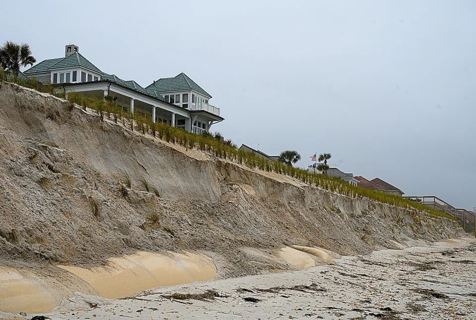
Sections of 2,200 feet of geotextile tubes installed in 2019 behind 13 private lots on Ponte Vedra Beach have been uncovered by erosion from a recent storm.
A walk down this 6-mile stretch of Florida beach might feel different than others.
Some things are the same. Rolling waves reach into smooth sheets, polishing the beach. Seaweed and shells tumble and settle, tumble and settle.
Look to the land, and the view is unexpected. Dunes have been carved into jagged cliffs. Strange canvas tubing pokes out of eroding sand mounds.
Keep walking and the view changes again. Newly imported plants grip a rebuilt dune, the result of an expensive human project.
Ponte Vedra Beach is just one place that provides a firsthand view of all the problems storm surge and high tides and sea-level rise bring in with them.
Seawalls jut from the sand, blamed by some for additional erosion elsewhere. Residents installed over 2,000 feet of geotextile tubing along the beaten dunes, with mixed results.
Meanwhile, their homes peer over a sand cliff’s edge.
“People are trying to beat Mother Nature,” said Nancy Condron, who built a home on this beach with her husband in 2008. “And what they really need to do is move their structures back and have a natural dune.”
Condron has been vocal in her opinions, having built west of the state’s coastal construction limits, but debates persist.
“It’s depressing.”
Sea-level rise is deeper than tides, more than the beach
This slice of Florida nearly captures sea-level rise in its full scope.
The sea advances on St. Johns County with a deadly combination of naturally higher tides, empowered storms and saltwater intrusion. It will impact generations of businesses, deeply historic neighborhoods, freshwater public supply wells, sparkling new subdivisions and oceanfront mansions alike.
But accelerated sea-level rise isn’t just a beachfront problem.
From threatened heritage to salty forests, oyster farms and inland flooding, voices across the region show this threat and its mitigation are far more complex than higher tides.
The rising sea reaches places you would not expect.
One tide gauge in the nation broke its record for high-tide flood days over the past year.
It was far inland, just outside Delaware City along Delaware Bay and about 20 miles from Wilmington, Delaware.
Places up and down the entire East Coast are menaced by sea-level rise’s impacts compounding the force of tides and storms: centuries of Black history, generations of businesses on Philadelphia’s Schuylkill River, headstones in colonial New England cemeteries, millennia of indigenous Florida heritage.
One of the oldest Black American communities feels current turning against them
She raised all the air conditioners 18 inches.
Lincolnville Museum and Cultural Center’s executive director Gayle Phillips in St. Augustine doesn’t have the budget to approach large mitigation projects, so she makes hands-on fixes. “We didn’t want to invest in AC units that were just going to be subjected to flooding,” Phillips said.
The effort came after Hurricane Matthew. Across much of Lincolnville’s east and south sides, flooding occurs during high tide and heavy rain.
Phillips is no stranger to taking her shoes off to get to work.
The museum, cradled by its historically Black neighborhood of Lincolnville, is devoted in part to celebrating the history of those taken involuntarily over this ocean centuries ago.
St. Augustine is the oldest continuously occupied European settlement in the country. Tourists come for its history, architecture and the white quartz sand of its beaches.
Now St. Augustine is fighting the sea to preserve indigenous artifacts, colonial Spanish antiquity and modern Black history. Newly freed slaves established the now-historic district of Lincolnville inside a city already more than 450 years old.
In 1964, Lincolnville hosted a famed Martin Luther King Jr. sit-in. Not only would King be arrested in St. Augustine that June, he would be in the city to learn the Civil Rights Act had passed.
History is baked into these 45 blocks of southwest peninsula.
The Lincolnville museum finds itself in competition with historical settlements, buildings and landmarks all around it for precious funds to preserve its own piece of heritage — in a place where there’s almost as much history as there is water.
Water’s winning.
But Lincolnville is just one neighborhood, and competition for funding is already steep. Phillips is not alone in her concern that the history she safeguards will be sacrificed for something more popular.
She said the Lincolnville museum cannot afford drainage improvements to its parking lot right now. It could be hard to imagine visitors taking off their shoes, wading through frequent flood waters, to reach her doors.
Lincolnville didn’t rank as highly as the Castillo de San Marcos fort, among other sites, in a recent city assessment of archaeological value. Historic tourism is worth $2.9 billion.
Pennsylvania brewpub fights back against storms, tides and sea-level rise
Up and down East Coast states, impact reaches well inland of the high tide line.
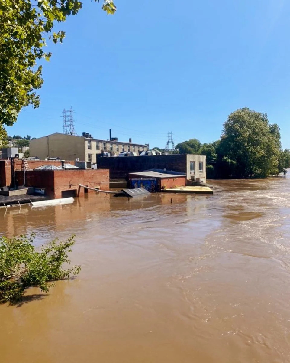
Mike Rose watched the damage unfold under a clear sky.
After the raging storm commanded attention all night, Pennsylvania officials continued to warn of a Schuylkill River surge near Philadelphia. More than 17 feet was expected by 8 a.m. It crested just short of that.
Rose watched from an off-site monitor as the cameras streamed the destruction until the power went out. The 66-year-old is used to occasional flooding, but this was different.
He returned to nearly three feet of mud.
Gelled between toppled equipment, saturated walls and debris, brown slime coated the guts of his restaurant. Massive brewpub tanks had been lifted and dropped. Remains blocked any path to Manayunk Brewing Company’s back patio, typically overlooking a quietly flowing river, several yards below.
“Did I think I was going to open up this time? I didn’t think so,” Rose recalled, perched at the bar. “I said: ‘I don’t know if I want to do this. I’m stripped. I’m just stripped of strength.”
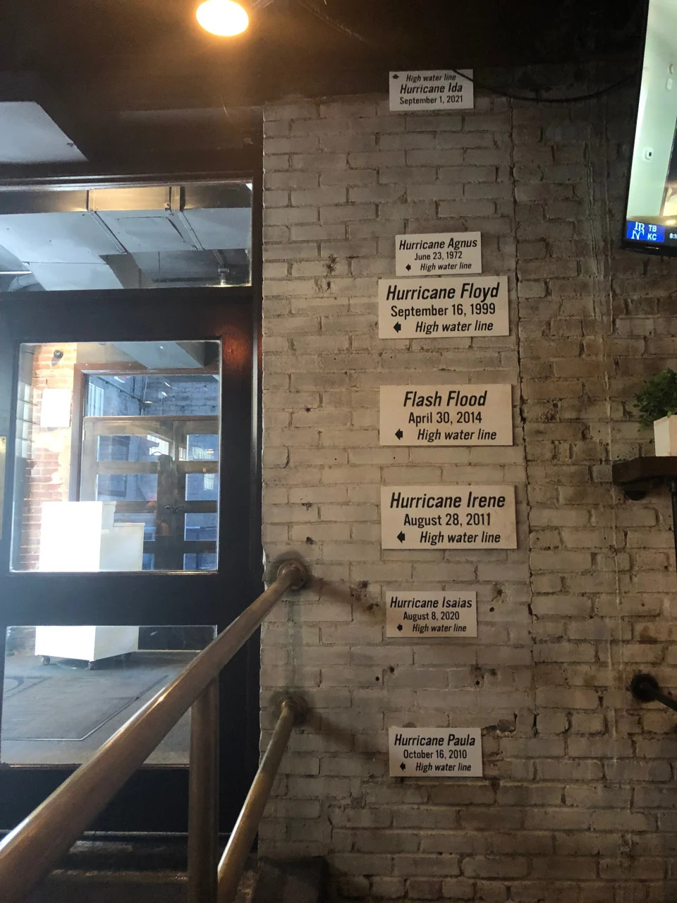
Remnants of Hurricane Ida brought a Schuylkill River surge that near-completely engulfed Manayunk Brewing Restaurant and Bar on Sept. 2, 2021, in northwest Philadelphia. The brewpub, having made hundreds of its own craft beers since 1996, reopened after six months of repairs as a restaurant and bar.Hurricane Irene, Hurricane Isaias, an unnamed flash flood in 2014, Agnes from 1972 — various high-water lines climb the wall in Manayunk Brewing Restaurant and Bar, in Philadelphia, on July 22, 2020. Black arrows mark each floodwater peak.
He swiped through photos on his phone. Employees shoveled mud. Ruined wiring ripped from the walls. Pieces of kitchen equipment were shoved in a heap against the iron street gate.
From the Chesapeake to Massachusetts bays, Ida brought surges several feet above typical high tide levels.
Rising seas can spell problems for inland communities. High tides and strengthened storm surges push water higher in nearby rivers during extreme storms, and into floodplains.
Rivers across Pennsylvania and New Jersey broke record levels.
Higher tides also push back on rivers, preventing flow back into the sea. Meanwhile, fresh water from extreme rainfall can start stacking up.
If it can’t drain into watersheds, it will find new routes.
Charged by climate change, stronger storms expose weaknesses
“Hurricanes have multiple elements or drivers or mechanisms here,” said Ning Lin, associate professor of civil and environmental engineering with Princeton University. “Sea-level rise is one piece.
“Looking at the joint probability between rainfall and surge, with sea-level rise, we found that extreme joint hazards can become much more frequent in our future climate.”
The strongest drivers for this, Lin said, are more intense rainfall — as a warming planet draws more water into the atmosphere, contributing to heavier storms — and a rising sea.
She said more research is needed to model for these impacts, together. Ida already exposed mid-Atlantic infrastructure shortcomings.
Rose may feel too busy for all the science. He has his third restaurant to run.
Nearly $2 million in Ida repairs later, the brewpub reopened in February. Repairing beer tanks proved too expensive. “We’re not making our own beer anymore,” Rose said. “That’s devastating to us.”
Kitchen equipment sits on wheels. Newly polished floors replace any carpeting. Electric panels were moved to the second floor.
Over Rose’s shoulder, small signs climb the gray bricks. Markers for Hurricane Irene, Hurricane Isaias, an unnamed flash flood in 2014, Agnes in 1972 — the various high-water lines stretch back to the building’s time as a wool mill. Black arrows mark floodwater peaks.
The edge of Ida’s small, white sign meets the ceiling. And it points up.
Underground, another waterline snakes its way inland.
Saltwater seeps underground into critical freshwater wetlands
Only the notes of historians remain to tell the story of the Pamlico people.
They lived along the Albemarle and Pamlico sounds for thousands of years, on the now-North Carolina coast, gliding dugout canoes through wetland forest threaded with teeming creeks and rivers.
This is “TaTaku” — where land and sea meet the sky — but the Pamlico vanished within 150 years of European settlers’ arrival. Men, women and children were decimated by smallpox and absorbed into other tribes.
Scientists fear the Albemarle-Pamlico Peninsula could follow a similar path. Freshwater wetland forests and shrubby evergreen bogs could be decimated by rising seas and absorbed by advancing coastal marsh.
Wildlife refuges protect more than 450,000 acres, hosting migratory birds, rare pocosin peat bogs and the sole wild population of red wolves in the nation. Today, fewer than two dozen remain.
With no escape, the cedars, pines and pocosin bogs starve under an onslaught of rising water. On this peninsula, Atlantic white cedars have virtually disappeared.
Sea water presses forward into the estuary, past Outer Banks barrier islands. Salinity levels creep higher, pushing into groundwater supplies and washing overland during high tides and storm surges.
These rolling pulses already arrive more often.
Once the sea water arrives, trapped by roads and other changes in elevation, it can stay for weeks, or even months — saturating the roots of the trees.
Forests could be completely overtaken, said Elliott White Jr., assistant professor at Stanford University. Satellite photos show the landward march. A dense, brown fringe “gets thicker and thicker year after year.”
If the losses documented over 25 years continue without widespread restoration, White said, the wetland forests could disappear by the end of this century.
The insidious flow of salts below ground also threatens freshwater wells and agriculture across the region. Farmers on the peninsula, who raise corn, soybeans, wheat, potatoes and cotton, have seen salt in their fields, said Rebekah Martin, Coastal NC National Wildlife Refuges Complex project leader.
“Ghost forests” can grow almost slowly enough to miss. Yet these dying woods appear from Maine to Miami, bending back along the Gulf of Mexico.
Stripped of their leaves and bark, trees become gaunt skeletons. Gradually forests and bogs give way to more salt-tolerant thickets.
“I’ve seen palm tree ghost forests in Florida and red spruce ghost forests in Canada,” said Matt Kirwan, associate professor with Virginia Institute of Marine Science. “They all share a similar origin.”
A group of University of South Florida researchers concluded the Big Bend’s coastal forest is dying at “an unprecedented rate.”
Hurricane Sandy left a ghost forest of white cedar in New Jersey.
In the Chesapeake Bay region, more than 80,000 acres of forest have turned to marsh in the last 150 years. That number could increase fivefold by 2100, Kirwan predicts.
New corridors would have to be considered for wildlife to retreat, Martin said. And more people and places could be exposed to intensifying storms typically buffered by marsh.
On the Albemarle-Pamlico Peninsula, once-vital forests could be lost to history.
Unwitting oysters part of a plan to fortify shorelines
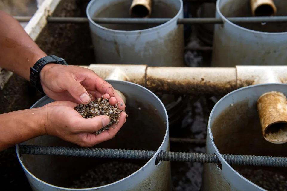
Rolling between Scott Budden’s fingers, a baby oyster resembles a grain of sand. Its tiny shell, still translucent in the gray morning, is already the perfect shape.
Its life with Budden begins here on Kent Island, Maryland. Farmers must tailor the crop’s controlled life cycle with the whims of changing waters, rising tides and shifting salinity.
After outgrowing land tanks, having savored algae and phytoplankton, the adolescent oyster will eventually move north to the Chester River. Waves will crash through hundreds of similar surface floats, transferring energy to the bundled mollusks lining several acres.
The oyster will return to Eastern Bay to finish. The water is saltier down here.
Scott Budden with a handful of seed oysters on July 26, 2022, destined for oyster reefs. In term of broader restoration, Joseph Gordon of Pew says the Chesapeake Bay is already the most massive shellfish restoration project in the world, central to a life system stretching from Maine to Florida. “It’s the beating heart of the Atlantic coast,” he said.Oyster tattoos on the arm of Scott Budden on July 26, 2022. He escaped his Washington, D.C., finance job in 2012 to come work on Kent Island.
Today, his prize crop joins a growing list of natural tools to fight against the very waters that foster it. Experts say even these oysters raised for a plate can also help fortify shorelines, like millions once did on their own.
“Growing the shellfish aquaculture industry can benefit the entire ecosystem,” said Joseph Gordon, U.S. East Coast project director with Pew Charitable Trusts. His group co-sponsored an initiative to buy millions of oysters from farmers like Budden, who were lacking the usual restaurant demand, and re-establish them in the bay.
The initiative’s reach extended to shellfish growers up the mid-Atlantic and New England, following an idea that has established itself to grow much like the oysters themselves: Mitigating climate change can mimic the natural world.
What’s a living shoreline?
One farm offers a payoff Budden doesn’t often consider.
On a stretch of coast, he notices an exposed beach has slowly washed away. But the same erosion, near Eastern Neck Island, Maryland, isn’t seen on his side.
“I’ve noticed there’s some dampening effect,” said the 36-year-old. “Basically, as waves come through, the energy is transferred to the floats, the floats then transfer that energy to the oyster. Which, actually, makes a better oyster.”
His casual observations echo the experts and other projects. Mitigations have been moving “from gray to green” to combat the effects of rising sea.
“For a long time, when we needed to stop erosion along the shoreline, we put in a hard structure,” said Molly Mitchell, a research assistant professor with the Virginia Institute of Marine Science. Think bulkheads, riprap, seawalls.
“They don’t provide good habitat for animals, and they don’t have the other benefits of natural beaches and marshes, like actually reducing wave energy.”
“Living shorelines” — from adding marsh and grass, to building shellfish breakwaters — have been growing in popularity as an alternative to shoreline hardening.
Scott Budden washes a bin by the dock on July 26, 2022. Today, his prize crop joins a growing list of natural tools to help the very waters that foster it. “Adding oysters can even help other interconnected habitats, like salt marsh and underwater seagrass — and together, these can increase the integrity and resilience of the coast by stabilizing shorelines to better withstand storms and storm surge,” said Joseph Gordon, U.S. East Coast project director with Pew Charitable Trusts.
Oyster reefs once thrived on Eastern shores, before humans decimated populations in the early 1800s. Oysters built on top of one another as others died, creating a solid structure.
“Rocks and seawalls aren’t going to evolve as the water gets steeper,” Mitchell said. “If you use an oyster reef, the oysters will actually grow on it — and the structure will get taller and taller as sea level rises.”
It can’t work everywhere. These solutions take best to systems with more moderate wave energy, like the Chesapeake Bay, or rivers and sounds.
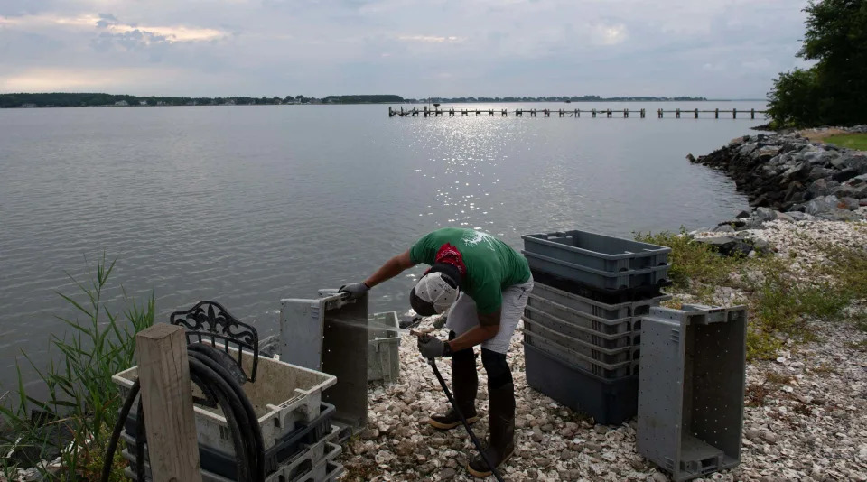
Back at the dock, Budden and his team watch saltwater drizzle through a churning tumbler, cleaning their harvest. Those measuring too small plunk back to the bay below.
His crop has always had a role to play in protecting the coast, but today shoreline communities may need to get more creative.
“We’ve got a couple million market oysters in the water, another three or four million have been put through the nursery this year,” he said. “Still, just a drop in the bucket.”
This article is part of a USA TODAY Network reporting project called “Perilous Course,” a collaborative examination of how people up and down the East Coast are grappling with the climate crisis. Journalists from more than 35 newsrooms from New Hampshire to Florida are speaking with regular people about real-life impacts, digging into the science and investigating government response, or lack of it.