Real estate: US homeowners have lost $2.3 trillion since June: Redfin data
Dylan Croll – February 22, 2023
U.S. homeowners have lost $2.3 trillion since June, according to a new report from the real-estate brokerage Redfin. The total value of U.S. homes was $45.3 trillion at the end of 2022, down 4.9% from a record high of $47.7 trillion in June. That figure signifies the largest June-to-December percentage decline since 2008.
The report comes amid increased mortgage rates as the Fed tries to curb inflation. The 30-year fixed mortgage rate sat at 6.36% in December, about twice what it was at the start of 2022. Though rates fell in early February, they’ve since risen back to December levels to the dismay of buyers.
Consequently, Americans find themselves more reluctant to buy homes and prices have dropped. The median U.S. home sale price was $383,249 in January, which was up just 1.5% from the previous year, according to the report.
Redfin highlighted the Bay Area, noting that the region had seen the biggest drop in real-estate value compared to other parts of the country. For instance, the total value of San Francisco homes fell 6.7% in December, to $517.5 billion, a $37.3 billion decline year over year.
“Three of my listings recently went under contract after sitting on the market for more than a month,” said Ali Mafi, a Redfin real estate agent in San Francisco featured in the note. “They all had a few showings here and there in the fall, but no buyer wanted to pull the trigger. And then suddenly in the new year, we had 10 or 15 people touring each property.”
Meanwhile, the report pointed out, the Florida housing market has remained robust, with the largest increase in real-estate value compared to other parts of the country. The total value of homes in Miami rose 19.7% year over year ($77 billion) to $468.5 billion in December.
“Florida’s housing market is being sustained by folks moving in from the North and as of recently, the West Coast,” said Elena Fleck, Florida real estate agent featured in the report. “People are pouring in from New Jersey and New York, in large part because Florida has relatively affordable homes and no income tax. They can get a lot more bang for their buck here.”
The report noted that U.S. cities are doing much worse than U.S. suburbs. While the value of urban homes increased 2.5% to $10.8 trillion year over year, the value of suburban properties jumped 6.4% year over year, to $25.4 trillion, in December.
“The housing market has shed some of its value, but most homeowners will still reap big rewards from the pandemic housing boom. The total value of U.S. homes remains roughly $13 trillion higher than it was in February 2020, the month before the coronavirus was declared a pandemic,” said Redfin Economics Research Lead Chen Zhao in the report.
“Unfortunately, a lot of people were left behind. Many Americans couldn’t afford to buy homes even when mortgage rates hit rock bottom in 2021, which means they missed out on a significant wealth building opportunity,” Zhao added.
Dylan Croll is a reporter and researcher at Yahoo Finance.
San Francisco holds its breath to find out how much it will cost to protect its waterfront from sea level rise
David Knowles, Senior Editor – February 22, 2023
San Francisco’s waterfront. (Getty Images)
SAN FRANCISCO — On a brisk February morning, a portable orange traffic sign set up near the intersection of Mission Street and Embarcadero shuddered in the wind, blinking a warning to passing drivers: “Caution: King tides.”
Waves from San Francisco Bay now regularly breach the pier and spill into the streets at this spot during tidal surges and helped convince city officials that sea level rise caused by climate change is no longer a problem that can be ignored.
“It was into my second year that I realized that my whole job and the organization was going to do this work,” Port of San Francisco executive director Elaine Forbes, who was appointed to her position in 2016 by then-Mayor Ed Lee, said beneath the Ferry Building’s broken clock tower, its hands fixed to either high noon or midnight as it undergoes repairs. “You’re on the line of defense.”
A semi-independent entity, the port oversees 7.5 miles of the city’s coastal facilities along the bay, leasing out a wide array of properties, including landmarks like Fisherman’s Wharf, Pier 39, the Ferry Building, a cruise ship terminal and Oracle Park, where the Giants play baseball. Its revenues are crucial to the city’s bottom line, and in 2018 Forbes mobilized her office to help ensure the passage of Prop A, a voter initiative that raised $425 million in taxpayer funds to begin addressing repairs and seismic upgrades to a 3-mile section of the city’s crumbling, more-than-100-year-old sea wall in anticipation of sea level rise.
“We said at the time, this is really a down payment for the problem,” Forbes recounted.
Since then, projections for how bad that problem will get have only become more dire. In 2020, the Legislative Analyst’s Office, the nonpartisan fiscal and policy adviser to the California Legislature, issued a report stating that under a scenario of continued high greenhouse gas emissions, San Francisco could see as much as 7 feet of sea level rise by 2100.
A graphic from a 2020 report by California’s Legislative Analyst’s Office.
In response to that grim new estimate, Forbes and the port’s commissioners announced last fall that they were partnering with the U.S. Army Corps of Engineers to conduct a comprehensive yearlong study examining how best to protect the vulnerable waterfront. Doing nothing, everyone seemed to agree, was not an option.
“The increased frequency of flooding that you’ll see as the bay comes up and you have more frequent tidal flooding, the numbers are in the billions in terms of the damages that will accumulate from that,” Brian Harper, a director of planning with the Army Corps, told Yahoo News.
But just as significant increases in sea level will result in monumental damages, adequately protecting communities from the additional rise will also become much more expensive. Complicating San Francisco’s efforts, the pandemic has badly diminished revenues from tourism and financial district foot traffic, forcing port officials to go hat-in-hand to city, state and federal entities in search of money to use to harden the coastline against rising waters.
“We’re not even at a scale to pretend to be able to pay for this project,” Forbes said. “We have a $114 million balance sheet, maybe a little higher. If we’re lucky, we have a $25 million capital budget that we squeeze out of our net revenues.”
While noting that any estimate on how much a fix will cost depends on what the Army Corps recommends in its report, Forbes speculates that the range could end up between $10 billion and $30 billion. Other experts, however, believe that guess could be too low.
Pier 14 in the Embarcadero district of San Francisco. (Getty Images)
“Projects like this have never, ever been built for the initial cost estimate,” said Peter Gleick, a climate scientist and the founder of Oakland’s Pacific Institute, which in 1990 conducted California’s first-ever report on how sea level rise would impact the Bay Area. “It’s not just sea level rise. It’s the big storm in addition to sea level rise that’s the issue. Seven feet of sea level rise is devastating, and then on top of that you have the extreme storm and then the king tides on top of 7 feet. That’s when the real damages are felt, and they’re felt long before they reach 7 feet.”
While many Americans still doubt the existence of climate change or whether climate change represents a threat serious enough to spend billions to address, coastal communities across the country have already begun heeding the wake-up call issued by scientists. San Francisco is just one of several U.S. cities to seek help from the Army Corps of Engineers in recent years. Others include Charleston, S.C., Miami and Boston. As the reality of the situation and the costs associated with it continue to sink in, more and more cash-strapped communities will no doubt seek federal assistance.
“Our standard cost sharing for flooding coastal projects is 65% federal, 35% local,” Harper said.
But federal money for projects designed and proposed by the Army Corps is by no means guaranteed.
A king tide washes up along the Embarcadero in San Francisco on Jan. 3, 2022. (Brontë Wittpenn/The San Francisco Chronicle via Getty Images)
“Each step of the way, we need an authorization from Congress and we need appropriation of funding to move to the next step,” Harper said. “Our steps are: Study it, design it, construct it and then operate it. So in each of those stages we would be going back to the Congress with an updated status of where we are and request for appropriation to move to the next stage.”
With the GOP back in the majority in the House of Representatives, it’s unclear how future requests for climate adaptability from the Corps will be received. Not a single Republican, after all, voted in favor of the Inflation Reduction Act, and many lawmakers who abhor large federal outlays have already begun looking for ways to kill its climate provisions. Yet much of the funding for hardening ports and waterfronts was allocated in the bipartisan Infrastructure Investment and Jobs Act, and Harper notes that the Corps continues to get approval for large projects.
“The administration incorporated authorization for all federal infrastructure agencies to specifically address climate resilience across the country, but [also] in urban settings like San Francisco and other large cities,” Harper said. “Some of this is still evolving and developing as federal agencies and their local and state counterparts figure out how to make those partnerships come together. The climate resilience aspect is continually evolving.”
Seeing the future
Kevin Costner in the 1995 movie “Waterworld.” (Ben Glass/Universal/Kobal/Shutterstock)
Of all the consequences of climate change, sea level rise has so far remained something of an abstraction for many in the general public. While the oceans have indeed risen by an average of 8 to 9 inches since the 1880s, that difference can seem laughable when compared with Hollywood’s dystopian portrayal of what the future will look like. “Waterworld,” set in the year 2500, envisioned a world in which the polar ice caps and glaciers have completely melted away and sea levels have risen by 24,000 feet.
Since the 1995 debut of that film, the U.S. Geological Survey has released its own estimate of what an ice-free world would mean, concluding that “global sea level would rise approximately 70 meters (approximately 230 feet), flooding every coastal city on the planet.”
Given the swift transition to renewable sources of energy over the past few years, that outcome may also turn out to be too pessimistic. But until we dramatically slow the burning of fossil fuels, the planet will almost certainly continue to warm, causing the seas to keep rising. Though today’s 8 to 9 inches of sea level rise may not seem headline-worthy, almost half of the amount (3.8 inches) has occurred since 1990, according to the National Oceanic and Atmospheric Administration (NOAA). The pace of that rise, scientists predict, is poised to increase dramatically in the coming decades.
To better understand what multiple feet of additional sea level rise will mean for the nation’s coastlines, NOAA created its Sea Level Rise Viewer tool. When one toggles up to 7 feet of rise in San Francisco, Pier 39, Fisherman’s Wharf, Oracle Park and the $1.4 billion Chase Center, where the Golden State Warriors play basketball, are all shaded light blue, meaning they will be submerged in water. Forbes’s office on Pier 1, the Ferry Building next door and a good chunk of the financial district would also be permanently flooded, with access to multiple underground BART and Muni stations needing to be sealed off.
A screengrab from NOAA’s Sea Level Rise Viewer tool showing the San Francisco area with 10 feet of sea level rise.
But how seriously should people take the Legislative Analyst’s Office upper-end prediction?
“It’s based on very sophisticated model assumptions,” Gleick said. “There’s a range of estimates. We don’t know how fast the big ice masses on Greenland and Antarctica are going to destabilize, but 1 to 2 meters by 2100 is not out of the bounds of reality and what we can expect.”
The same year San Francisco voters passed Prop A with 82.7% of the vote in order to “protect $100 billion of assets and economic activity,” a poll from the University of California, Santa Barbara, found that 84% of area residents said they believed global temperatures were rising and would continue to do so, the highest number of any community in the U.S.
“It does help when they’re able to see the change. With flooding during a king tide they say, ‘Hey, this is different,’” Harper acknowledged. “But that doesn’t really capture the severity of what they’re going to see over a longer time frame.”
Like NOAA, the Army Corps has turned to visual aids to help residents understand what they will be up against, posting its own sea level rise viewer that overlays flooding depictions onto photos of urban areas.
“Here’s your downtown area. Here are buildings you should recognize because they’re in your community, and here’s what that future tidal event is going to look like,” Harper said.
If “Waterworld” was too fantastical, another sci-fi film, “Blade Runner 2049,” offered viewers a glimpse of something less abstract in scenes that featured a massive sea wall that shields Los Angeles from the encroaching ocean. That kind of utility-over-aesthetics approach has, despite the obvious drawbacks, been suggested in San Francisco to replace and dwarf the existing sea wall.
“We don’t just want to build a vertical wall. We could do that and just solve it, but that’s not good for anybody,” saidKevin Conger, president and founding partner of CMG Landscape Architecture, a San Francisco firm the port has hired to begin drawing up ideas for what a fortified sea wall would look like. “In order to adapt and hold the water back we need to elevate portions of the waterfront, but that causes another problem, which is inland flooding, because all the stormwater that’s running down by gravity is no longer going to be able to run out to the coast because you’ve elevated that edge.”
An aerial view of the Port of San Francisco shrouded in fog. (Getty Images)
Conger, Forbes and Harper all agree that whatever the final plan that emerges following the release of the Army Corps report, it should prioritize community access to the waterfront while preparing it for what’s ahead. To address the varying needs and limitations of the waterfront, the designs will include a mixture of solutions, including reinforcing and raising the existing sea wall; creating new parks that will help channel floodwaters; adding pumping stations; upgrading stormwater systems; elevating roadways, light rail tracks and even some buildings, and floodproofing the lower floors of many others; and, quite possibly, retreating from some areas altogether.
“Fundamentally, it’s looking at maintaining the line of defense, managing water, adapting with water or allowing water,” Forbes said. “There’s various alternatives that will work best in different locations along the waterfront.”
Despite the immense scale of the project, Conger stresses the long view.
“We get so sort of locked into a fear of change. But we’re always tinkering with our cities and changing things. For us to work on these projects, it’s not like we build them and walk away and we’re done, especially as landscape architects,” he said. “Our designs change constantly.”
In November, the Army Corps will present its draft to the public, inviting comments from a range of stakeholders before incorporating that feedback. Assuming congressional authorization follows suit, Harper said, the budgeting for design could come as soon as 2026.
“Depending on what the project is, design can be two to five years. Construction, again, can be two to five years. It will depend on what the specific project recommendation is coming out of the report, and it’s all subject to congressional action and administration support,” Harper said.
Calculating the final costs could itself be a years-long project. In surveys conducted by the port, for instance, San Francisco residents have prioritized elevating the 1898 Ferry Building to keep it above the rising waters. But lifting a three-story building that contains more than 200,000 square feet of office and commercial space and a 15-story clock tower won’t be cheap. Nor will be addressing possible groundwater contamination at Hunters Point Naval Shipyard, now an 866-acre federal Superfund site. Last June, a civil grand jury released a report that stated, “As the sea level rises, shallow groundwater near the shore rises with it, and can cause flooding, damage infrastructure, and mobilize any contaminants in the soil.” While the cleanup of buried radioactive soils is being overseen by the Environmental Protection Agency and state officials, the city is “poorly prepared,” the report said, for how sea level rise could cause the problem to spread into nearby lower-income neighborhoods.
San Francisco’s Ferry Building. (Getty Images)
All the coastal challenges facing San Francisco could become much more difficult depending on the precarious fate of the Thwaites Glacier in Antarctica. In 2021, a study was published that concluded that the Florida-size glacier was at risk of collapse in the following five years. Already, Thwaites accounts for roughly 4% of global sea level rise annually, and its collapse would, in the short term, translate into 2 more feet of rise. Because Thwaites helps hold other glaciers in place, however, its destruction would result in a cascading catastrophe resulting in an additional 10 feet of sea level rise.
Of course, the contiguous 7.5-mile stretch operated by the Port of San Francisco is just one small part of the Bay Area coastline that will be impacted by sea level rise.
“You’re going to have to build sea walls around the Oakland airport, the San Francisco airport, and sea walls around San Jose,” Gleick said. “When we did our study there were 29 wastewater treatment plants that were vulnerable to a meter of sea level rise.”
Though Gleick notes that San Francisco has plenty of options when it comes to combating rising seas, many poorer and less well-situated places aren’t as lucky.
“I guess the whole point is, this is just a little hint of the huge costs that are going to be associated with climate change in general and sea level rise in particular if we don’t slow these [temperature] changes,” he added.
The housing market correction has already caused homeowners to lose $2.3 trillion
Lance Lambert – February 22, 2023
For 124 consecutive months, spanning the bottom of the housing crash in February 2012 through the top of the Pandemic Housing Boom in June 2022, U.S. home prices posted positive month-over-month growth. That streak, of course, came to an abrupt end last year as the Fed’s inflation fight set off a correction in home prices.
On one hand, since their peak, national home prices have only fallen by a few percentage points through November, according to the seasonally adjusted Case-Shiller National Home Price Index. On the other hand, the ongoing housing correction is already starting to have a financial, and psychological, impact on homeowners.
On Wednesday, Redfin published a report finding that the total value of U.S. homes has fallen $2.3 trillion since the start of the home price correction.
“The total value of U.S. homes was $45.3 trillion at the end of 2022, down 4.9% ($2.3 trillion) from a record high of $47.7 trillion in June. That’s the largest June-to-December drop in percentage terms since 2008,” writes Redfin researchers.
Let’s be clear: While there’s certainly a home price correction rolling through many markets nationwide, most homeowners are still up big-time since the pandemic’s onset.
“The housing market has shed some of its value, but most homeowners will still reap big rewards from the Pandemic Housing Boom,” Redfin researchers said in the report. “The total value of U.S. homes remains roughly $13 trillion higher than it was in February 2020, the month before the coronavirus was declared a pandemic.”
Is this home price correction almost over? It depends on who you ask.
Among the 29 major real estate forecasters, six firms think national home prices will either rise or remain flat in 2023. Meanwhile, 23 major real estate forecasters think national home prices will fall further this year.
On Wednesday, minutes released from the recent FOMC meeting showed that Federal Reserve officials believe “valuations in both residential and commercial property markets remained high” and “that the potential for large declines in property prices remained greater than usual.”
Whenever a group like Redfin says “U.S. home prices,” it means a national aggregate. On a regional level, this home price correction (or lack thereof) continues to vary.
Among the country’s 400 largest housing markets tracked by Zillow, 276 have seen local home prices fall from their seasonally adjusted 2022 peak. Another 124 markets remain at their 2022 peak price.
The markets with the biggest declines, including places like Bend, Ore. (down 9.2%) and Phoenix (down 6.3%), are disproportionately located across the Pacific Coast and Southwest.
“On a regional basis, we project larger declines across the Pacific Coast and Southwest regions—which have seen the largest increases in inventory on average—and more modest declines across the Mid-Atlantic and Midwest—which have maintained greater affordability over the past couple years,” wrote Goldman Sachs in a recent report.
Climate change is making disasters like hurricanes more devastating and frequent, and Floridians are already being forced to flee.Getty; Marianne Ayala/Insider
The state’s climate exodus has already begun
As many residents will be proud to tell you, the thousand-odd islands that make up the Florida Keys are one of a kind: there is no other place in the world that boasts the same combination of geological, ecological, and sociological characteristics. The islands have a special, addictive quality about it, an air of freedom that leads people to turn their backs on mainland life.
The Keys are also the first flock of canaries in the coal mine of climate change. Over the past few years, the residents of these islands have been forced to confront a phenomenon that will affect millions of Americans before the end of the century. Their present calamity offers a glimpse of our national future.
Nature is changing. Today’s hurricanes tend to be stronger, wetter, and less predictable than those of the last century. They hold more moisture, speed up more quickly, and stay together longer. It’s difficult to tell for certain what role climate change plays in any individual storm, but in the case of Hurricane Irma — which slammed the Keys in September 2017 — there is little doubt that the warmth of the Caribbean Sea made the storm more powerful, allowing the vortex to regain strength overnight as it barreled toward the islands. As global warming continues to ratchet up the temperature of our oceans, we can expect more storms like Irma. The danger to the Keys doesn’t end with hurricane season, either: a slow but definite rise in average sea levels over the past decade has contributed to an increase in tidal flooding, leaving some roads and neighborhoods inundated with salt water for months at a time.
In the five years since Irma, the bill has come due. The hurricane made undeniable what previous floods had only suggested: that climate change will someday make life in the archipelago impossible to sustain. The storm was the first episode in a long and turbulent process of collapse, one that will expand over time to include market contraction, government disinvestment, and eventually a wholesale retreat toward the mainland. Irma may not have destroyed the Keys in one stroke, but the storm ran down the clock on life on the islands, pushing conches (the Keys’ unique name for residents) into a future that once seemed remote. The impulse to stay, which once bespoke a conch’s devotion to his or her adopted home, now looks a little more like denial. The decision to leave, on the other hand, which once signified surrender, now looks more like acceptance of the inevitable.
Florida’s Great Displacement
The term “climate migration” is an attempt to explain why people leave one place in favor of another; it assigns motivation to movements that may be voluntary or involuntary, temporary or permanent. Yet even if the primary cause for migration is clear, there are still countless other factors that influence when, where, and how someone moves in response to a disaster. It’s this messiness that is reflected in the word “displacement”: the migratory shifts caused by climate change are as chaotic as the weather events that cause them.
For some families the decision to depart the Keys was easy. The storm was a traumatic event, more than enough to convince many people that life on the islands was too dangerous to accept. They came back home, fixed up their houses, and got out. That was the case for Connie and Glenn Faast, who left the island city of Marathon for the mountains of North Carolina after spending almost 50 years in the Keys. “It was pretty much immediate,” Connie told me. “It’s just too hard to start over when you get older. We couldn’t risk it.”
The Faasts had lived the kind of life you can only live in the Keys: Connie worked on commercial fishing boats and in a local aquarium, while Glenn owned a boat maintenance company and raced Jet Skis in his spare time. They had stuck it out in the Keys through several major storms, including 2005’s Hurricane Wilma, which brought five feet of water to their little island and totaled three of their cars; Connie still shudders when she remembers the image of her husband wading through the water around their house with snakes climbing all over him, clinging to him for shelter from the flood. The Faasts had second thoughts after that storm, but the Keys were paradise, and besides, they didn’t know where else they would go.
When Irma came 12 years later, though, the choice was much easier. During the evacuation, it took the Faasts a week to find a decaying hotel in Orlando where they could wait out the storm. As the hurricane passed over the center of the state, it knocked out their power, leaving them and their pets to spend the night in 100-degree heat without air conditioning. “That was it for us,” she said. They had to get out — not just out of the Keys, but out of Florida altogether.
When they returned to Marathon, they discovered that their home was the only one in the neighborhood with an intact roof. They put the house on the market as soon as they could, but it took a year for the place to sell, in part because property values had risen so steeply that most people in the area couldn’t afford to buy.
The storm had scared many people off, but it had also destroyed a quarter of the Keys’s housing stock, which drove up prices for the homes that survived. In the meantime, the Faasts saw their friends start to leave as well: one moved to Sarasota, another to Orlando, and a third friend, who had been the first-ever mayor of Marathon, talked about moving to central Florida.
“We thought it would be devastating when we left,” Connie said, “because we love the Keys. But when we pulled out of there, we were so, so relieved.”
No more housing
Hundreds of people like the Faasts left the Keys of their own volition in the years after Irma, deciding one way or another that the risks of staying there outweighed the benefits. But perhaps the more turbulent phenomenon after the storm was the involuntary displacement caused by the shortage of affordable housing on the islands. The storm destroyed not only the massive mobile home parks on islands like Big Pine, but also hundreds of so-called downstairs enclosures, small apartment-style units that sat beneath elevated homes.
It also wiped out dozens if not hundreds of liveaboard boats and older apartment complexes in island cities like Marathon. These trailer parks and apartment complexes had been havens for resort waiters, boat buffers, and bartenders, allowing them to get a foothold in an archipelago that had long ago become unaffordable for anyone who wasn’t rich. Now all that housing was gone, and FEMA’s 50% rule — which prohibits improvements to structures that cost more than 50% of its market value — prohibited most trailers and downstairs enclosures from being rebuilt.
Many of those who had been lucky enough to own small homes or campers hadn’t been able to afford insurance, which meant they missed out on the payouts that went to wealthy homeowners and part-time vacationers. To make matters worse, the government of the Keys couldn’t build enough new homes to fill the gap created by the storm: the state had long ago imposed a de facto cap on the number of building permits Monroe county — which encompasses the islands — could issue, an attempt to make sure the population did not grow too large to evacuate the islands in a single day. Thus it was impossible for most residents either to rebuild their old homes or to buy new ones.
Some of those who lost their homes were able to crash with friends and family, and others got by living in tents or trailers, but others resorted to a forest homeless encampment. The lack of housing made the storm survivors feel as though they were stuck in a permanent limbo: life on the islands became a game of musical chairs, in which only the highest bidders could end up with a seat.
Delaying the inevitable
Debra Maconaughey, the rector at St. Columba Episcopal Church in Marathon, spent the years after Irma trying to forestall this involuntary displacement. When the storm hit, Maconaughey and much of her congregation were in Ireland, retracing the steps of the original St. Columba, and by the time they returned to the Keys it was clear that housing would be the defining challenge of the next few years. “Everybody’s house was destroyed. That’s what people would need the most.”
We were speaking in the church’s open-air pavilion, where Maconaughey had been delivering outdoor sermons even before the coronavirus pandemic. Irma had weakened the timbers that supported the roof of the central chapel, forcing the church to move worship outside.
The Great Displacement: Climate Change and the Next American Migration by Jake BittleSimon & Schuster
In the first week Maconaughey was back, she helped transform St. Columba’s campus into a massive shelter for boaters who had lost their homes in the storm, cramming two dozen air mattresses into a loft that had previously been used for an after-school program. The next week, Maconaughey and her congregation installed approximately two dozen trailers around Marathon, giving the boaters a long-term place to stay.
Maconaughey knew there was no chance the county government would restore all the housing that had been lost in the storm, but after a year went by, she found herself shocked at how little had been rebuilt. A nonprofit land trust had erected only a handful of new cottages and a $50 million state program called Rebuild Florida had repaired only two homes, a pittance compared to the thousands of dwellings that had been swept away.
So Maconaughey called up the nonprofits who were funding St. Columba’s relief efforts and made an unconventional proposal: the church, she proposed, would buy some derelict housing and fix it up. She had her eyes set on a leaky, mold-filled apartment complex in Marathon that had been condemned for sewage issues a few years earlier. The apartment complex finally opened in the summer of 2020, providing cut-rate housing to 16 families who had been staying on couches or in trailers since the day the storm hit.
Never coming back
But for every person who found permanent shelter, there were more who could not afford to wait for the islands to recover. This wasn’t only because people didn’t want to return, but also because there were no homes to which they could return. Maconaughey told me with distaste that in several places along Marathon’s beachfront, developers have built single large mansions on lots that once contained three or four small homes each.
The lack of affordable housing in turn created a labor shortage: fire and police departments couldn’t find enough officers to fill their shifts, boat maintenance companies struggled to locate buffers and repairmen, and many hotels went shorthanded through the on-season rush. When employers exhausted their hiring options on the islands, Maconaughey said, they started to hire workers from the mainland towns of Homestead and Florida City, who take a two-hour bus ride in either direction to work for minimum wage.
“I think people are really struggling, and it’s just below the surface,” she said. “We’re a tourist area, so it’s in our best interests to make it look nice from the highway, but there’s hidden pain.”
Maconaughey told me about the church sexton, Mike, who was driven out of the Keys by Irma. Mike showed up after the recession in a homeless shelter in Marathon. He was blind, and when he first arrived at the shelter he couldn’t take a shower or put on clothes without assistance. After a year in the shelter, Mike started attending services at St. Columba, and soon displayed a great talent for weaving wooden canes and chairs, a craft he often practiced on the church pavilion after sermons. He also taught the kids in the after-school program how to play chess.
Mike was on the Keys as the storm approached, not with the congregation in Ireland. He first sought refuge in the massive Miami hurricane shelter, but by the time he got there, that shelter was full. As shelters in Florida all reached capacity, emergency officials herded evacuees from the Keys up toward Georgia, North Carolina, and Virginia, offering them bus transportation as far as they were willing to go. Mike was unsure when he would be able to return to the Keys, so he asked for a ticket to Minnesota, where he grew up. He was never able to get back.
“We kind of lost him,” Maconaughey said. “He got on a bus to evacuate and now he’s gone. He was a huge part of our community … You have to ask yourself, do you ever recover from something like this?”
Jake Bittle is a climate reporter and staff writer for Grist.
How Climate Change Is Making Tampons (and Lots of Other Stuff) More Expensive
Coral Davenport – February 18, 2023
Cotton left over after the harvest in Meadow, Texas, Jan. 19, 2023. (Jordan Vonderaar/The New York Times)
When the Agriculture Department finished its calculations last month, the findings were startling: 2022 was a disaster for upland cotton in Texas, the state where the coarse fiber is primarily grown and then sold around the globe in the form of tampons, cloth diapers, gauze pads and other products.
In the biggest loss on record, Texas farmers abandoned 74% of their planted crops — nearly 6 million acres — because of heat and parched soil, hallmarks of a megadrought made worse by climate change.
That crash has helped to push up the price of tampons in the United States 13% over the past year. The price of cloth diapers spiked 21%. Cotton balls climbed 9%, and gauze bandages increased by 8%. All of that was well above the country’s overall inflation rate of 6.5% in 2022, according to data provided by the market research firms NielsonIQ and The NPD Group.
It’s an example of how climate change is reshaping the cost of daily life in ways that consumers might not realize.
West Texas is the main source of upland cotton in the United States, which in turn is the world’s third-biggest producer and largest exporter of the fiber. That means the collapse of the upland cotton crop in West Texas will spread beyond the United States, economists say, onto store shelves around the world.
“Climate change is a secret driver of inflation,” said Nicole Corbett, a vice president at NielsonIQ. “As extreme weather continues to impact crops and production capacity, the cost of necessities will continue to rise.”
Halfway around the world in Pakistan, the world’s sixth-largest producer of upland cotton, severe flooding, made worse by climate change, destroyed half that country’s cotton crop.
There have been other drags on the global cotton supply. In 2021, the United States banned imports of cotton from the Xinjiang region of China, a major cotton-producing area, out of concerns about the use of forced labor.
But experts say that the impact of the warming planet on cotton is expanding across the planet with consequences that may be felt for decades to come.
By 2040, half of the regions around the globe where cotton is grown will face a “high or very high climate risk” from drought, floods and wildfires, according to the nonprofit group Forum for the Future.
Texas cotton offers a peek into the future. Scientists project that heat and drought exacerbated by climate change will continue to shrink yields in the Southwest — further driving up the prices of many essential items. A 2020 study found that heat and drought worsened by climate change have already lowered the production of upland cotton in Arizona and projected that future yields of cotton in the region could drop by 40% between 2036 and 2065.
Cotton is “a bellwether crop,” said Natalie Simpson, an expert in supply chain logistics at the University at Buffalo. “When weather destabilizes it, you see changes almost immediately,” Simpson said. “This is true anywhere it’s grown. And the future supply that everyone depends on is going to look very different from how it does now. The trend is already there.”
Return of the Dust Bowl
For decades, the Southwestern cotton crop has depended on water pumped from the Ogallala Aquifer, which stretches underneath eight western states from Wyoming to Texas.
But the Ogallala is declining, in part because of climate change, according to the 2018 National Climate Assessment, a report issued by 13 federal agencies. “Major portions of the Ogallala Aquifer should now be considered a nonrenewable resource,” it said.
That is the same region that was abandoned by more than 2 million people during the Dust Bowl of the 1930s, caused by severe drought and poor farming practices. John Steinbeck famously chronicled the trauma in his epic “The Grapes of Wrath,” about a family of cotton farmers driven from their Oklahoma home. Lately, the novel has been weighing on the mind of Mark Brusberg, a meteorologist at the Agriculture Department.
“The last time this happened, there was a mass migration of producers from where they couldn’t survive any longer to a place where they were going to give it a shot,” Brusberg said. “But we have to figure out how to keep that from happening again.”
In the years since, the farmland over the Ogallala once again flourished as farmers drew from the aquifer to irrigate their fields. But now, with the rise in heat and drought and the decline of the aquifer, those dust storms are returning, the National Climate Assessment found. Climate change is projected to increase the duration and intensity of drought over much of the Ogallala region in the next 50 years, the report said.
Barry Evans, a fourth-generation cotton farmer near Lubbock, Texas, doesn’t need a scientific report to tell him that. Last spring, he planted 2400 acres of cotton. He harvested 500 acres.
“This is one of the worst years of farming I’ve ever seen,” he said. “We’ve lost a lot of the Ogallala Aquifer, and it’s not coming back.”
When Evans began farming cotton in 1992, he said, he was able to irrigate about 90% of his fields with water from the Ogallala. Now that’s down to 5% and declining, he said. He has been growing cotton in rotation with other crops and using new technologies to maximize the precious little moisture that does arrive from the skies. But he sees farmers around him giving up.
“The decline of the Ogallala has had a strong impact on people saying it’s time to retire and stop doing this,” he said.
Kody Bessent, the CEO of Plains Cotton Growers Inc., which represents farmers who grow cotton across 4 million acres in Texas, said that land would produce 4 or 5 million bales of cotton in a typical year. Production for 2022 is projected at 1.5 million bales — a cost to the regional economy of roughly $2 billion to $3 billion, he said.
“It’s a huge loss,” he said. “It’s been a tragic year.”
From Cotton Fields to Walmart Shelves
Upland cotton is shorter and coarser than its more famous cousin, Pima cotton. It is also far more widely grown and is the staple ingredient in cheap clothes and basic household and hygiene products.
In the United States, most cotton grown is upland cotton, and the crop is concentrated in Texas. That’s unusual for a major commodity crop. While other crops such as corn, wheat and soybeans are affected by extreme weather, they are spread out geographically so that a major event afflicting some of the crop may spare the rest, said Lance Honig, an economist at the Agriculture Department.
“That’s why cotton really stands out, with this drought having such a big impact on the national crop,” Honig said.
Sam Clay of Toyo Cotton Co., a Dallas trader that buys upland cotton from farmers and sells it to mills, said the collapse of the crop had sent him scrambling. “Prices have gone sky-high, and all this is getting passed on to consumers,” he said.
Clay said he is experiencing the impacts himself. “I bought six pairs of Wranglers a year and a half ago for $35 a pair. I’m paying $58 a pair now.”
At least 50% of the denim in every pair of Wrangler and of Lee jeans is woven from U.S.-grown cotton, and the cost of that cotton can represent more than half the price tag, said Jeff Frye, the vice president of sustainability for Kontoor Brands, which owns both labels.
Frye and others who deal in denim did point out, however, that other factors have driven up price, including the ban on imports of Xinjiang cotton, high fuel costs and the complicated logistics of moving materials.
Among the cotton products most sensitive to the price of raw materials are personal care items like tampons and gauze bandages, since they require very little labor or processing like dying, spinning or weaving, said Jon Devine, an economist at Cotton Inc., a research and marketing company.
The price of Tampax, the tampon giant that sells 4.5 billion boxes globally each year, started climbing fast last year.
In an earnings call in January, Andre Schulten, chief financial officer for Procter & Gamble, which makes Tampax, said the costs of raw materials “are still a significant headwind” for the company across several products, forcing the company to raise prices.
On a recent Sunday at a Walmart in Alexandria, Virginia, several shoppers said they had noticed rising prices.
“The price of a regular box of Tampax has gone up from $9 to $11,” said Vanessa Skelton, a consultant and the mother of a 3-year-old. “That’s a regular monthly expense.”
Make Way for Polyester
Cotton farmers say that Washington can help by increasing aid in the farm bill, legislation that Congress is renewing this year.
Taxpayers have sent Texas cotton farmers an average of $1 billion annually over the past five years in crop insurance subsidies, according to Daniel Sumner, an agricultural economist at the University of California, Davis.
Farmers say they’d like expanded funding for disaster relief programs to cover the impact of increasingly severe drought and to pay farmers for planting cover crops that help retain soil moisture. They also say they hope that advances in genetically modified seeds and other technologies can help sustain Texas cotton.
But some economists say it may not make sense to continue support a crop that will no longer be viable in some regions as the planet continues to warm.
“Since the 1930s, government programs have been fundamental to growing cotton,” Sumner said. “But there’s not a particular economic argument to grow cotton in West Texas as the climate changes. Does it make any economic sense for a farm bill in Washington, D.C., to say, ‘West Texas is tied to cotton?’ No, it doesn’t.”
In the long run, it could just mean that cotton is no longer the main ingredient in everything from tampons to textiles, said Sumner, “and we’re all going to use polyester.”
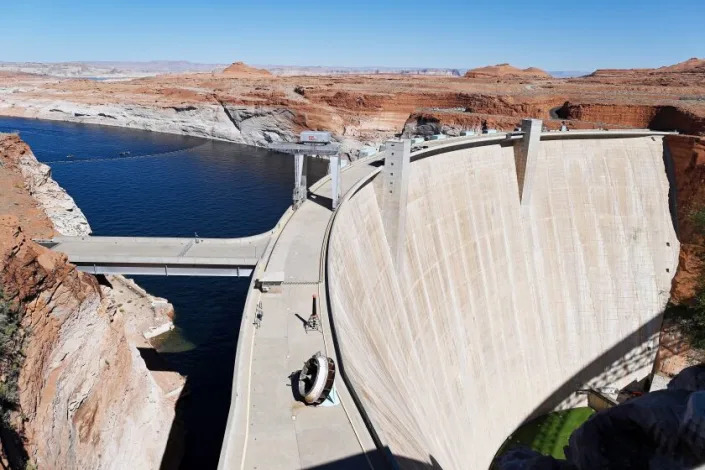
As the Colorado River shrinks, federal officials consider overhauling Glen Canyon Dam
Ian James – February 18, 2023
The Colorado River’s decline threatens hydropower at Glen Canyon Dam. Now, officials are looking at retooling the dam to deal with low water levels. (Joshua Lott / Washington Post)
The desiccation of the Colorado River has left Lake Powell, the country’s second-largest reservoir, at just 23% of capacity, its lowest level since it was filled in the 1960s.
With the reservoir now just 32 feet away from “minimum power pool” — the point at which Glen Canyon Dam would no longer generate power for six states — federal officials are studying the possibility of overhauling the dam so that it can continue to generate electricity and release water at critically low levels.
A preliminary analysis of potential modifications to the dam emerged during a virtual meeting held by the federal Bureau of Reclamation, which is also reviewing options for averting a collapse of the water supply along the river. These new discussions about retooling the dam reflect growing concerns among federal officials about how climate change is contributing to the Colorado River’s reduced flows, and how declining reservoirs could force major changes in dam management for years to come.
Among the immediate concerns is the threat of the reservoir dropping below the dam’s power-generating threshold. If that were to occur, water would only flow through four 8-foot-wide bypass tubes, called the outlet works, which would create a chokepoint with reduced water-releasing capacity.
“There is now an acknowledgment, unlike any other time ever before, that the dam is not going to be suited to 21st century hydrology,” said Kyle Roerink, executive director of the environmental group Great Basin Water Network, who listened to the meeting. “They’re not sugarcoating that things have to change there, and they have to change pretty quickly.”
Those who participated in the Feb. 7 meeting included dozens of water mangers, representatives of electric utilities, state officials and others. They discussed proposals such as penetrating through the dam’s concrete to make new lower-level intakes, installing a new or reconfigured power plant, and tunneling a shaft around either side of the dam to a power plant, among other options.
The Interior Department declined a request for an interview, but spokesperson Tyler Cherry said in email that the briefing was part of broader conversations with state officials, tribal leaders, water managers and others “to inform our work to improve and protect the short-term sustainability of the Colorado River System and the resilience of the American West to a changing climate.”
Roerink and two other people who listened to the webinar told The Times that cost estimates for several alternatives ranged from $500 million to $3 billion. The agency will need congressional approval and will have to conduct an environmental review to analyze options.
The Bureau of Reclamation’s presentation, given by regional power manager Nick Williams, included some additional alternatives that wouldn’t require major structural modifications of the dam. Those options included adjusting operations to maximize power generation at low reservoir levels, studying ways of using the existing intakes at lower water levels, and making up for the loss of hydroelectric power by investing in solar or wind energy.
Glen Canyon Dam stands 710 feet tall, anchored to the canyon’s reddish sandstone walls in northern Arizona, about 320 miles upstream from Lake Mead, the nation’s largest reservoir. The dam has been controversial since its inception, with environmental activists and others arguing the reservoir was unnecessary and destroyed the canyon’s pristine ecosystem.
Lake Powell and Lake Mead have declined over the last 23 years during the most severe drought in centuries. Federal officials have sought to boost Powell’s levels in recent months by reducing the amount of water they release downstream until the spring runoff arrives. They’ve said they may need to further cut water releases.
A central concern is that if the water drops below minimum power pool — 3,490 feet above sea level under the current operating rules — the main intakes would need to be shut down and water would instead flow through the dam’s lower bypass tubes. Because of those tubes’ reduced capacity, that could lead to less water passing downstream, shrinking the river’s flow in the Grand Canyon and accelerating the decline of Lake Mead toward “dead pool” — the point at which water would no longer pass through Hoover Dam to Arizona, California and Mexico.
Federal officials prepared the initial studies of alternatives for Glen Canyon Dam using $2 million that the Bureau of Reclamation secured as part of $200 million for drought response efforts.
According to a slide presentation shown at the meeting, officials see potential hazards in some of the six alternatives. Piercing the dam’s concrete to create new low-level or mid-level intakes, for example, would entail “increased risk from penetration through dam,” the presentation says.
They also describe risks due to possible “vortex formation,” or the creation of whirlpools above horizontal intakes as the water level declines. Their formation could cause damage if air is pulled into the system. The presentation says one alternative would involve lowering the minimum power pool limit and possibly installing structures on the intakes to suppress whirlpools, but it said this still would not allow for the water level to go much lower.
One of the possible fixes includes installing a new power plant that would generate electricity with water flowing from the bypass tubes, or taking a similar approach using existing infrastructure. Another would involve excavating a tunnel to the left or right side of the dam, and installing a power plant underground or in the riverbed.
Other options include changing operations at both Glen Canyon and Hoover dams “to maximize power generation under low flow conditions using existing infrastructure.”
“Any of the options are going to be very expensive and they’re going to be very time-consuming,” said Leslie James, executive director of the Colorado River Energy Distributors Assn., who participated in the meeting.
James praised the Bureau of Reclamation for “starting the processes to look at structural options like this.”
“I see what they’re doing here as getting an early start and at least evaluating everything that they can to look and see what may be feasible,” James said. She said she hopes Congress will provide the necessary funding to ensure continued electricity flowing from Glen Canyon Dam, given “how important hydropower is to entire communities.”
Her association represents nonprofit electric utilities that buy power produced by Glen Canyon Dam and other dams that are part of the Colorado River Storage Project. The association includes members in Arizona, Colorado, Nevada, Utah, New Mexico and Wyoming. The utilities supply power in cities, rural areas, irrigation districts and tribal communities.
Power from the dam has long been a vital energy source, though its output has decreased dramatically in recent years as Lake Powell has declined. During the 2022 fiscal year, Glen Canyon Dam generated 2,591 gigawatt-hours of electricity, enough to power more than 240,000 average homes for a year.
James said electric utilities across the region have had to make up for the reduced hydropower by turning to other costlier sources.
“It’s a real challenging time,” James said. “And it is the people in these communities that are ultimately being impacted with higher electricity bills.”
Lake Powell’s level is projected to rise this spring with runoff from the above-average snowpack in the Rocky Mountains. But that boost in water levels is expected to have a limited effect on the deep water deficit that has accumulated over more than two decades.
And in the long term, scientific research indicates warming and drying will continue to take a major toll on the river.
Scientists have found that roughly half the decline in the river’s flow since 2000 has been caused by higher temperatures, that climate change is driving the aridification of the Southwest, and that for each additional 1 degree Celsius (1.8 degrees Fahrenheit) of warming, the river’s average flow will probably decrease about 9%.
Environmental activists have for years urged the federal government to consider draining Lake Powell, decommissioning the dam and storing the water downstream in Lake Mead.
Activists who listened to the Bureau of Reclamation’s presentation said they welcome the agency’s examination of the issues at Glen Canyon Dam but would prefer to see a broader analysis that evaluates other options, including draining the reservoir.
In a report last year, Roerink’s Great Basin Water Network and two other groups warned that the “antiquated plumbing system inside Glen Canyon Dam represents a liability to Colorado River Basin water users who may quickly find themselves in legal jeopardy and water supply shortfalls.”
“The bureau is admitting that the dam is a liability,” Roerink said. “From my perspective, that’s a good first step.”
Beyond the current focus on trying to prop up hydropower generation, Roerink said, “I think we need an option that is just a bypass option without a power plant at the end of it.”
Roerink said he expects there will be a lot of debate about issues such as evaporation from the reservoir and the high costs of modifications to the dam.
“Is it all worth it? Are the taxpayer dollars going to be worth it for those electrons?” Roerink said. “How long will it be until this just proves itself to be a futile exercise?”
John Weisheit, an activist who has advocated for removing the dam, said he was delighted to hear federal officials openly discussing these options for the first time.
“I’m glad we’re having this conversation. It’s long overdue,” said Weisheit, who is co-founder of the group Living Rivers.
Weisheit said he also thinks the agency’s alternatives aren’t broad enough, and leave unanswered questions about the dam’s life span.
“I think it’s imperative that we know exactly what the life span of this dam is,” Weisheit said. “There is so much more that needs to be discussed.”
Weisheit said one major concern should be the accumulation of sediments in the bottom of the reservoir, which, according to a recent federal survey, has lost nearly 6.8% of its water-storing capacity.
Another issue with the agency’s current alternatives, he said, is that they wouldn’t solve problems of intakes or bypass tubes sucking in air at low water levels, “just like everybody’s bathtub does,” potentially causing cavitation that would pit and tear into metal, damaging the infrastructure.
Weisheit said he also was concerned about potential threats to endangered fish in the Grand Canyon.
Overall, the modifications to the dam that the federal government is considering would be “too much investment for very little return,” Weisheit said. “And it’s going to take a long, long time.”
Weisheit said he favors the option of investing in solar and wind energy. Instead of spending up to $3 billion trying to squeeze a shrinking amount of power from the dam, he said, “you can build a lot of solar cells and turbines,” including nearby on the Navajo Nation, which needs electricity.
Weisheit said he thinks the situation shows Glen Canyon Dam isn’t needed.
“Take the dam out,” he said, “because it’s not the right dam for climate change.”
Water crisis in West: Massive reservoir Lake Powell hits historic low water level
Colorado River Basin water levels drop to historic low, states mandated to cut use More water is being taken from the river than it can provide.
Elizabeth Weise, USA TODAY – February 18, 2023
Lake Powell, the nation’s second-largest reservoir and one that provides water and power to millions of people in southern California, has reached its lowest levels since its first filling in the 1960s.
Its companion reservoir, Lake Mead, is at levels almost as low.
Together, these reservoirs, fed by the mighty Colorado River, provide the water 40 million Americans depend on. Despite the storms that brought heavy rain and snow to California and other Western states in January, experts say it would take years of such weather to replenish the West’s water resources.
“In the year 2000, the two reservoirs were 95% full. They’re roughly 25% full now,” said Brad Udall, a water and climate scientist at Colorado State University. “It’s hard to overstate how important the Colorado River is to the entire American southwest.”
What to know about the West’s ongoing water crisis:
An abandoned and once-sunken boat sits along the shoreline of Lake Powell in this May 2022 file photo. The white ring above shows how high the water level was when the lake was full.
What is Lake Powell?
Lake Powell is the nation’s second-largest reservoir. It was created by blocking the Colorado River at Glen Canyon in southern Utah and northern Arizona.
It stores water as part of the Colorado River Compact and produces electricity through the hydroelectric turbines in Glen Canyon dam.
Work on the dam that created Lake Powell began in 1956 and was finished in 1966. It took 16 years for it to fill. At its highest, in 1983, the lake was 3,708 feet above sea level.
Lake Powell hasn’t been this low since June of 1965, just two years after it began to fill with water.
The biggest worry: If the lake’s level falls much lower, it won’t be possible to get water out of it.
Why? Tubes that run water through its out of the lake and into eight hydroelectric turbines could soon be above the water. There are bypass tubes available below that point, but they weren’t designed for continuous use, so it’s not clear how they would fare.
Important quote: “If you can’t get water out of the dam, it means everyone downstream doesn’t get water,” said Udall. “That includes agriculture, cities like Los Angeles, San Diego and Phoenix.”
Will water stop flowing? “That’s a doomsday scenario,” said Bill Hasencamp, Colorado River resources manager for the Metropolitan Water District of Southern California. Before things get to that point the Department of the Interior will require reductions in use.
How long until water stops flowing downstream? If the lake falls another 32 feet – about the amount it fell in the past year – power generation concerns become more urgent, Udall said. Snowmelt this spring is forecast to bring levels up somewhat.
Why is the water level so low?
The water in Lake Powell is low because the amount of water in the Colorado River has been falling for decades. At the same time, demand has risen due to increased population growth in the West.
Overall, the river’s flow is down 20% in this century relative to the 20th century.
More than four scientific studies have pinned a large part of the decline on human climate change. It’s partly that there’s less rain and snow, partly that as temperatures rise, plants use more water and more water evaporates out of the soil which would otherwise have ended up in the river. In addition, the river itself experiences more evaporation.
“It’s unfortunate that the largely natural occurrence of a drought has coincided with this increasing warming due to greenhouse gases,” said Flavio Lehner, a professor of atmospheric sciences at Cornell University. “That has brought everything to a head much earlier than people thought it would.”
What about Lake Mead and the Hoover Dam?
Lake Mead is the nation’s largest reservoir, a companion to Lake Powell. Mead was created when the Hoover Dam was completed in 1935. It supplies water and power to Arizona, California, New Mexico and Mexico.
Lake Mead’s level is 1,047 feet above sea level. You would have to go back to April of 1937, also two years into its initial filling, to find levels that low. It is forecast to have a new record low next summer, said Hasencamp.
The lake isn’t low enough yet to cause concerns about getting water out, but any hope of it refilling is years away, if ever, due to lowered rain and snow and increasing evaporation.
Some of America’s largest cities depend on the water from Lake Mead. “It’s 90% of the water supply to Las Vegas, 50% to Phoenix, effectively 100% to Tucson and 25% to Los Angeles,” said Udall.
What will happen if water levels keep dropping?
The Department of the Interior had asked the seven states of the Colorado River Compact to come up with a plan to cut between 2 and 4 million acre-feet of water by January. They weren’t able to come up with an agreement.
Because of that, it’s expected that the Department of the Interior’s Bureau of Reclamation, which oversees water management, will mandate one sometime next year.
“This is apparently a decent (water) year, but still, if it turns dry again there are some pretty big reductions on tap and every state could be affected,” said Hasencamp.
It will be painful but it doesn’t mean the area can’t thrive.
“The West might look different,” said Hasencamp. “You might not see the lush lawns of today and endless fields of alfalfa, but you will see thriving communities and agricultural regions.”
Through a year of war in Ukraine, the U.S. and most European nations have worked to help counter Russia, in supporting Ukraine both with armaments and in world energy markets. Russia was Europe’s main energy supplier when it invaded Ukraine, and President Vladimir Putin threatened to leave Europeans to freeze “like a wolf’s tail” – a reference to a famous Russian fairy tale – if they imposed sanctions on his country.
But thanks to a combination of preparation and luck, Europe has avoided blackouts and power cutoffs. Instead, less wealthy nations like Pakistan and India have contended with electricity outages on the back of unaffordably high global natural gas prices. As a global energy policy analyst, I see this as the latest evidence that less wealthy nations often suffer the most from globalized oil and gas crises.
I believe more volatility is possible. Russia has said that it will cut its crude oil production starting on March 1, 2023, by 500,000 barrels per day in response to Western energy sanctions. This amount is about 5% of its current crude oil production, or 0.5% of world oil supply. Many analysts expected the move, but it raises concerns about whether more reductions could come in the future.
How Europe has kept the lights on
As Russia’s intent toward Ukraine became clear in late 2021 and early 2022, many governments and energy experts feared one result would be an energy crisis in Europe. But one factor that Putin couldn’t control was the weather. Mild temperatures in Europe in recent months, along with proactive conservation policies, have reduced natural gas consumption in key European markets such as Germany, the Netherlands and Belgium by 25%.
With less need for electricity and natural gas, European governments were able to delay drawing on natural gas inventories that they built up over the summer and autumn of 2022. At this point, a continental energy crisis is much less likely than many forecasts predicted.
European natural gas stockpiles are around 67% full, and they will probably still be 50% full at the end of this winter. This will help the continent position itself for next winter as well.
The situation is similar for coal. European utilities stockpiled coal and reactivated 26 coal-fired power plants in 2022, anticipating a possible winter energy crisis. But so far, the continent’s coal use has risen only 7%, and the reactivated coal plants are averaging just 18% of their operating capacity
The U.S. role
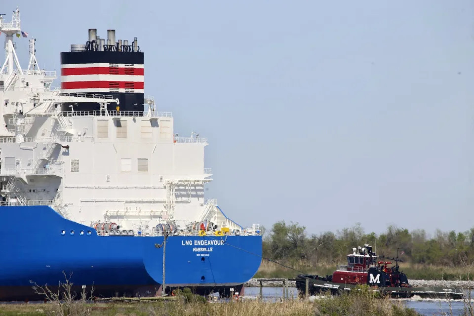
Record-high U.S. energy exports in the summer and fall of 2022 also buoyed European energy security. The U.S. exported close to 10 million cubic meters per month of liquefied natural gas in 2022, up 137% from 2021, providing roughly half of all of Europe’s imported LNG.
Although domestic U.S. natural gas production surged to record levels, some producers had the opportunity to export into high-priced global markets. As a result, surpluses of summer natural gas didn’t emerge inside the U.S. market, as might otherwise have happened. Combined with unusually hot summer temperatures, which drove up energy demand for cooling, the export surge socked U.S. consumers with the highest natural gas prices they had experienced since 2008.
Prices also soared at U.S. gas pumps, reaching or exceeding US$5 per gallon in the early summer of 2022 – the highest average ever recorded by the American Automobile Association. The U.S. exported close to 1 million barrels per day of gasoline, mainly to Mexico and Central America, plus some to France, and consolidated its position as a net oil exporter – that is, it exports more oil than it imports.
A tugboat helps guide the LNG Endeavor, a French liquefied natural gas tanker, through Calcasieu Lake near Hackberry, La., March 31, 2022. U.S. LNG exports to Europe reached record levels in 2022 as the continent prepared to sever energy ties with Russia. AP Photo/Martha Irvine
Much like Europeans, U.S. consumers had to pay high prices to outbid other global consumers for oil and natural gas amid global supply disruptions and competition for available cargoes. High gasoline prices were a political headache for the Biden administration through the spring and summer of 2022.
However, these high prices belied the fact that U.S. domestic gasoline use has stopped growing. Forecasts suggest that it will decline further in 2023 and beyond as the fuel economy of U.S. cars continues to improve and the number of electric vehicles on the road expands.
While energy prices were a burden, especially to lower-income households, European and American consumers have been able to ride out price surges driven by the war in Ukraine and have so far avoided actual outages and the worst recessionary fears. And their governments are offering big economic incentives to switch to clean energy technologies intended to reduce their nations’ need for fossil fuels.
Developing nations priced out
The same can’t be said for consumers in developing nations like Pakistan, Bangladesh and India, who have experienced the energy cutoffs that were feared but didn’t occur in Europe. Notably, Europe’s intensive energy stockpiling in the summer of 2022 caused a huge jump in global prices for liquefied natural gas. In response, many utilities in less developed nations cut their natural gas purchases, creating price-related electricity outages in some regions.
The energy challenge that the Russia-Ukraine crisis has bred in developing countries has intensified global discussions about climate justice. One less examined impact of giant clean tech stimulus plans enacted in wealthy nations, such as the United States’ Inflation Reduction Act, is that they keep much of the available funding for climate finance at home. As a result, some developing country leaders worry that a clean energy technology knowledge gap will widen, not shrink, as the energy transition gains momentum.
Worsening the problem, members of the G-7 forum of wealthy nations have tightened their monetary policies to control war-driven inflation. This drives up the cost of debt and makes it harder for developing countries to borrow money to invest in clean energy.
The U.S. is supporting a new approach called Just Energy Transition Partnerships, in which wealthy nations provide funding to help developing countries shift away from coal-fired power plants, retrain workers and recruit private-sector investors to help finance decarbonization projects. But these solutions are negotiated bilaterally between individual countries, and the pace is slow.
When nations gather in the United Arab Emirates in late 2023 for the next round of global climate talks, wealthy nations – including Middle East oil producers – will face demands for new ways of financing energy security improvements in less wealthy countries. The world’s rich nations pledged in 2009 to direct $100 billion yearly to less wealthy nations by 2020 to help them adapt to climate change and decarbonize their economies, but are far behind on fulfilling this promise.
U.N. Secretary-General Antonio Guterres has called on developed nations to tax fossil fuel companies, which reported record profits in 2022, and use the money to fund climate adaptation in low-income countries. New solutions are needed, because without some kind of major progress, wealthy nations will continue outbidding developing nations for the energy resources that the world’s most vulnerable people desperately need.
How dangerous was the Ohio chemical train derailment? An environmental engineer assesses the long-term risks
Andrew J. Whelton, Professor of Civil, Environmental & Ecological Engineering, Director of the Healthy Plumbing Consortium and Center for Plumbing Safety, Purdue University – February 15, 2023
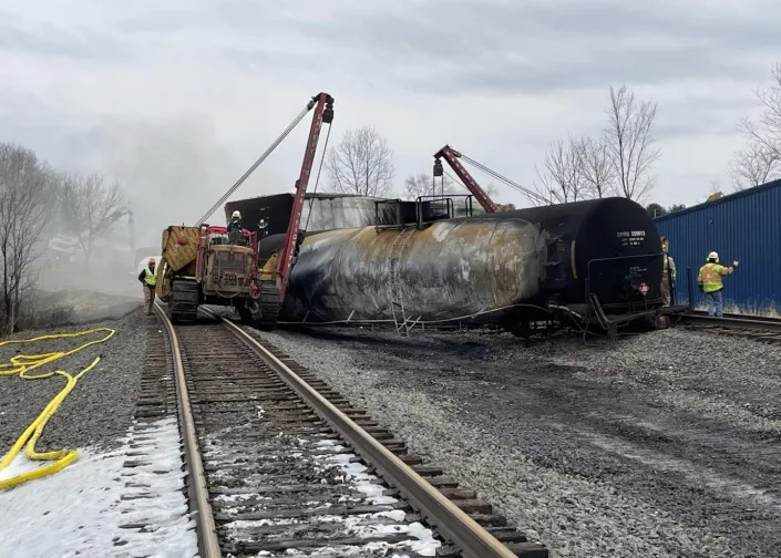
Headaches and lingering chemical smells from a fiery train derailment in East Palestine, Ohio, have left residents worried about their air and water – and misinformation on social media hasn’t helped.
State officials offered more details of the cleanup process and a timeline of the environmental disaster during a news conference on Feb. 14, 2023. Nearly a dozen cars carrying chemicals, including vinyl chloride, a carcinogen, derailed on the evening of Feb. 3, and fire from the site sent up acrid black smoke. Officials said they had tested over 400 nearby homes for contamination and were tracking a plume of spilled chemicals that had killed 3,500 fish in streams and reached the Ohio River.
However, the slow release of information after the derailment has left many questions unanswered about the risks and longer-term impact. We put five questions about the chemical releases to Andrew Whelton, an environmental engineer who investigates chemical risks during disasters.
Let’s start with what was in the train cars. What are the most concerning chemicals for human health and the environment long term, and what’s known so far about the impact?
The main concerns now are the contamination of homes, soil and water, primarily from volatile organic compounds and semivolatile organic compounds, known as VOCs and SVOCs.
The train had nearly a dozen cars with vinyl chloride and other materials, such as ethylhexyl acrylate and butyl acrylate. These chemicals have varying levels of toxicity and different fates in soil and groundwater. Officials have detected some of those chemicals in the nearby waterway and particulate matter in the air from the fire. But so far, the fate of many of the chemicals is not known. A variety of other materials were also released, but discussion about those chemicals has been limited.
State officials disclosed that a plume of contamination released into the nearby creek had made its way into the Ohio River. Other cities get their drinking water from the river, and were warned about the risk. The farther this plume moves downstream, the less concentrated the chemical will be in water, posing less of a risk.
Long term, the greatest risk is closest to the derailment location. And again, there’s limited information about what chemicals are present – or were created through chemical reactions during the fire.
It isn’t clear yet how much went into storm drains, was flushed down the streams or may have settled to the bottom of waterways.
There was also a lot of combusted particulate matter. The black smoke is a clear indication. It’s unclear how much was diluted in the air or fell to the ground.
How long can these chemicals linger in soil and water, and what’s their potential long-term risk to humans and wildlife?
The heavier the chemical, often the slower it degrades and the more likely it is to stick to soil. These compounds can remain for years if left unaddressed.
After the Kalamazoo River oil pipeline break in Michigan in 2010, the U.S. Environmental Protection Agency excavated a tributary where the oil settled. We’ve also seen from oil spills on the coasts of Alaska and Alabama that oil chemicals can find their way into soil if it isn’t remediated.
The long-term impact in Ohio will depend in part on how fast – and thoroughly – cleanup occurs.
If the heavily contaminated soils and liquids are excavated and removed, the long-term impacts can be reduced. But the longer removal takes, the farther the contamination can spread. It’s in everyone’s best interest to clean this up as soon as possible and before the region gets rain.
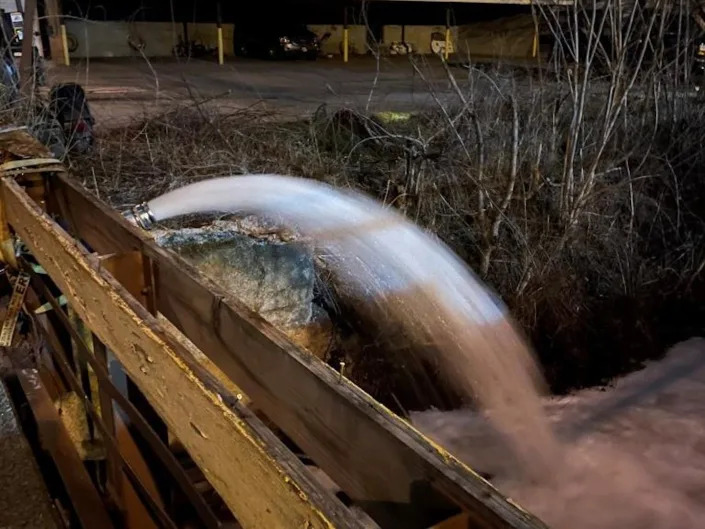
Air-stripping devices, like this one used after the derailment, can help separate chemicals from water. U.S. EPA
Booms in a nearby stream have been deployed to capture chemicals. Air-stripping devices have been deployed to remove chemicals from the waterways. Air stripping causes the light chemicals to leave the water and enter air. This is a common treatment technique and was used after an 2015 oil spill in the Yellowstone River near Glendive, Montana.
At the derailment site in Ohio, workers are already removing contaminated soil as deep as 7 feet (about 2 meters) near where the rail cars burned.
Some of the train cars were intentionally drained and the chemicals set on fire to eliminate them. That fire had thick black smoke. What does that tell you about the chemicals and longer-term risks?
Incineration is one way we dispose of hazardous chemicals, but incomplete chemical destruction creates a host of byproducts. Chemicals can be destroyed when heated to extremely high temperatures so they burn thoroughly.
The black smoke plume you saw on TV was incomplete combustion. A number of other chemicals were created. Officials don’t necessarily know what these were or where they went until they test for them.
We know ash can pose health risks, which is why we test inside homes after wildfires where structures burn. This is one reason the state’s health director told residents with private wells near and downwind of the derailment to use bottled water until they can have their wells tested.
The EPA has been screening homes near the derailment for indoor air-quality concerns. How do these chemicals get into homes and what happens to them in enclosed spaces?
Homes are not airtight, and sometimes dust and other materials get in. It might be through an open door or a window sill. Sometimes people track it in.
So far, the U.S. EPA has reported no evidence of high levels of vinyl chloride or hydrogen chloride in the 400 or so homes tested. But full transparency has been lacking. Just because an agency is doing testing doesn’t mean it is testing for what it needs to test for.
Media reports talk about four or five chemicals, but the manifest from Norfolk Southern also listed a bunch of other materials in tanks that burned. All those materials create potentially hundreds to thousands of VOCs and SVOCs.
Are government officials testing for everything they should?
Ohio and federal officials need to better communicate what they’re doing, why, and what they plan to do. It’s unclear what questions they are trying to answer. For a disaster this serious, little testing information has been shared.
In the absence of this transparency, misinformation is filling that void. From a homeowner’s perspective, it’s hard to understand the true risk if the data is not shared.
‘There’s No Spring Break Here’: Florida’s Gulf Coast Fights to Rebound After Hurricane Ian
Shannon Sims – February 14, 2023
Al Marti, 80, watches the waves roll in on a Sanibel beach as work continues to rebuild the area’s infrastructure devastated by Hurricane Ian, on Sanibel Island, Fla., Feb. 9, 2023. (Scott McIntyre/The New York Times)
On Sept. 28, Hurricane Ian made landfall on Cayo Costa, a barrier island northwest of Cape Coral and Fort Myers, Florida, as a Category 4 storm with sustained winds of more than 150 mph. Killing 149 people in Florida, it was the state’s deadliest hurricane since 1935. More than four months later, the storm’s extraordinary power remains evident: In Fort Myers Beach, multistory oceanfront apartment buildings are still just piles of twisted steel and concrete rubble, and massive shrimping boats sit tilted and smashed together like toys in the corner of a tub.
The storm’s wrath extended up and down the west coast of Florida. But Sanibel Island, one of the area’s most popular vacation destinations, was hit especially hard. The fish-hook-shaped barrier island, some 12 miles long and 3 miles across at its widest, was devastated. Even the causeway that connects it to the mainland was partly destroyed.
On a recent afternoon, sitting at a table outside the Sanibel Grill, which roof and water damage kept closed for months, the mayor of Sanibel, Holly Smith, 61, was blunt. “There’s no spring break here,” she said. “As far as the recovery of tourism, we have a long way to go.”
Smith said that during the storm, the island had “a complete washover” — the 12-foot storm surge covered everything.
Beth Sharer, 66, a homeowner on the island, said when she went back to her ravaged condo, she couldn’t find the high-water mark that flooding usually leaves. “And then I realized there wasn’t one: The water was higher than the entire apartment,” she said.
When Smith visited the island with Gov. Ron DeSantis in the days after the storm, the area looked like a war zone, she said. “It was like ‘Mad Max,’ with dirt across the roads.”
Fears of Becoming a ‘New Miami’
Before the hurricane, Sanibel and Captiva, a smaller island connected to the north of Sanibel by a short bridge, offered an estimated 2,800 lodging units, including hotel rooms and short-term rentals, according to the Sanibel & Captiva Islands Chamber of Commerce. Today there are just 155 available, the chamber said. “We’ve changed our communication strategy from promoting the island to helping manage guest expectations for the next 12 months,” said John Lai, CEO of the chamber, which is now encouraging visitors to sign up for “voluntourism” options like helping to clear trails at the nature reserve or clean debris from the beaches.
By comparison, Fort Myers Beach had 2,384 hotel rooms before the storm, according to the Lee County government. In the wake of the storm, none of those rooms were open. As of this month, 360 of those rooms were available — just 15% of prehurricane inventory.
Before the hurricane, JPS Vacation Rentals, a local agency, had 32 properties available in Fort Myers Beach, said Heidi Jungwirth, the owner. Seven of those remain standing, but all were damaged, and none are currently rentable, she said. She has turned her office into a distribution center for donations. Distinctive Beach Rentals, which used to be the largest vacation management company in Fort Myers Beach, with 400 properties, saw 380 of those units “wiped out,” said Tom Holevas, the area manager, adding that the company has now pivoted to offering more inland rentals.
At the Lighthouse Resort’s Tiki Bar & Grill, where today the bathroom doors are shower curtains and the kitchen consists of a grill behind the outdoor bar, Betsy Anderson, 50, expressed concern about the area’s future. She owns an apartment in Cape Coral, just inland from the beach, that she rents via Airbnb. She said she had several guests cancel after the storm because the beaches were closed, and she is currently renting to a couple fixing up their own flooded house on Sanibel.
She worries that the storm will accelerate change. “We don’t think it can come back,” she said, referring to the area’s laid-back character and “old Florida” style. “Now people are saying big investors are going to come in with big money and turn this into the new Miami.”
Reviving an Economic Lifeline
On Sanibel, the push to rebuild began early, in part because the island draws so many visitors from across the country to its famous shelling beaches. A temporary causeway opened less than two weeks after the storm, allowing a convoy of electrical companies’ cherry picker trucks to reach the island. On Oct. 19, the bridges — one lane in each direction, with reduced speed limits — were opened to residents. For the rest of 2022, piece by piece, the area started to come back online.
“This place is on a lot of people’s bucket lists,” said Smith, alluding to visitors who “just want a shell from Sanibel.” But it will be at least a year before the island can accommodate tourists in any numbers, she said.
It doesn’t help that the island’s beaches are currently suffering from Florida’s persistent red tide, which is caused by a higher-than-normal level of microscopic algae that produce toxins in the water, turning it a rusty brown color and killing fish. The tide can significantly affect visitors’ experiences, aggravating respiratory problems, leaving beaches littered with rotting sea life and discouraging time spent near the water.
Still, residents and businesses are trudging toward getting tourists — their economic lifeline — back to the shore.
In just the past month, the first hotel rooms reopened for visitors at Sanibel’s Island Inn and the ’Tween Waters Resort & Spa on Captiva Island.
Some restaurants that were only lightly damaged have reopened quickly. Others are now operating out of food trucks. Some shops are back open, too, and many outdoor activities are once again available: renting kayaks and stand-up paddleboards or chartering fishing boats.
In early February, the first wedding since the storm was held at ’Tween Waters; the Bailey-Matthews National Shell Museum reopened with limited hours; and the doomsday-ish electronic sign that met visitors as they came off the bridge into Sanibel — “ALL SANIBEL BEACHES CLOSED” — was turned off, as the first beaches were officially reopened to the public. There is a sense on the island now that the wheels of tourism are finally beginning to turn.
Still, many hotels, restaurants and businesses that cater to tourists are a long way from reopening their doors. Some, like Sanibel Inn, are essentially starting from scratch, their buildings in ruins.
That’s why businesses are handing visitors the most useful item a tourist can pick up in Sanibel today: a printed list of what’s open, where and when.
‘It Breaks Your Heart’
For now, a visit to the area is more a pledge of support than a vacation.
On a sunny day in early February, Lisa Taussig of Overland Park, Kansas, and Christy, her adult daughter, were among the few tourists on the beach in front of the Island Inn, where they were staying. They come to the island about three times a year, Taussig said, and this year is no different. “After the storm passed, we just said, ‘You know what? We’re going to come down here and support Sanibel,’” she said.
“You feel welcome here,” she added, before turning and gesturing to the series of plywood-covered, battered condo buildings behind her. “Now it feels isolated, and there aren’t the lush trees that are usually here.
“It breaks your heart,” she said.
In Fort Myers Beach, residents still pick up their mail at a trailer. Glass, nails and unidentifiable twisted debris remain scattered along the ground. Around town, many flags, bumper stickers and T-shirts are emblazoned with “FMB STRONG.”
On a recent Saturday, a tiny spot called the Beach Bar was packed with a crowd of locals who looked storm-weary but exuded an ornery refusal to retreat. Even before the storm, the bar’s physical structure — right off Estero Boulevard, the beach strip that’s historically packed with visitors cruising in top-down vehicles — didn’t amount to much: It was a two-story, open-air wooden building facing the water. Now only the concrete slab remains.
But that hasn’t stopped the regulars. The crowd showed up with beach chairs and coolers, which they set up on the concrete. “They’re operating right now with a trailer, two outhouses and a band,” said Randy Deutsch, 72, from Chicago, who said he’d been coming to the bar since 1972.
“Our concept didn’t change,” said Matt Faller, the manager. “Cold beer, live music, toes in the sand.”