France, in the grip of fourth heat wave this year, faces a historic drought
August 9, 2022
Sunflowers suffer from lack of water as parts of France endure its fourth heat wave of the year. (Aurelien Morissard / Associated Press)
France is in the midst of its fourth heat wave as the country faces what the government warns is its worst drought on record.
National weather agency Meteo France said the heat wave began Monday in the south and is expected to spread across the country and last until the weekend.
Overall, the southern half of France expects daytime temperatures of up to 104 degrees that won’t drop below 68 at night.
The high temperatures aren’t helping firefighters battling a wildfire in the Chartreuse Mountains near the Alps in eastern France, where authorities have evacuated around 140 people.
Meteo France said this week’s heat wave will not be as intense as the one last month, when several regions experienced record-breaking temperatures. But the high temperatures come during the most severe drought ever recorded, according to the government. Last month was the driest July since measurements began in 1959.
Some French farmers have started to see drops in production, especially in soy, sunflower and corn yields.
Water restrictions in place include daytime irrigation bans and the limiting of water usage to people and livestock and to keeping aquatic species alive.
The government said last week that more than 100 municipalities can’t provide drinking water through taps and need water to be trucked in.
The heat also forced energy giant EDF to temporarily cut power generation at some of its nuclear plants, which use river water to cool reactors.
Here’s what the Inflation Reduction Act will do to combat climate change
Ben Adler, Senior Editor – August 9, 2022
The Inflation Reduction Act (IRA) passed by the Senate over the weekend will pursue an extremely wide and varied array of strategies intended to combat climate change. The $369 billion in climate-related spending over 10 years targets five areas: consumer clean energy costs, decarbonizing various sectors of the economy, domestic clean energy manufacturing, environmental justice, and agriculture and land use. Taken together, these programs would help the U.S. reduce its greenhouse gas emissions by 40% from 2005 levels by 2030, and would save an estimated 3,700 to 3,900 lives per year thanks to cleaner air from a reduction in burning fossil fuels.
Steam rises from the cooling towers of the coal-fired power plant at Duke Energy’s Crystal River Energy Complex in Crystal River, Fla. (Dane Rhys/Reuters)
This approach represents a break from many past congressional proposals designed to reduce the greenhouse gas emissions that cause global warming, most of which proposed using a singular, overarching policy, such as taxing emissions or requiring tradable permits for emissions. Those measures all died in Congress, but this one made it through the Senate and is expected to pass the House later this week.
“The whole package in terms of dealing with climate change is a long-overdue improvement,” former Democratic Rep. Henry Waxman told Yahoo News on Tuesday. Waxman was chair of the House Energy and Commerce Committee for many years, and he co-wrote a bill that passed the House but died in the Senate that would have capped carbon emissions and gradually reduced the number of tradable credits for them, a system known as cap-and-trade.
“Unlike other efforts in the past, such as cap-and-trade or a carbon tax, this approach gives a lot of incentives, financial especially, through the tax code and appropriations for industry to accomplish a reduction in emissions,” Waxman said. “This climate proposal has very little, if any, regulation. It’s a lot of incentives to develop, in effect, a partnership with industry and the government … to sharpen up the technology to accomplish our goals.”
Here’s a guide to the biggest programs in each bucket of climate policies, and what they will mean for American families.
Consumer clean energy costs
Solar panels create electricity on the roof of a house in Rockport, Mass. (Brian Snyder/Reuters)
The IRA would pour money into helping homeowners, especially those with low and moderate incomes, and lower their carbon footprint and their energy bills by helping them transition to more efficient heating and cooling systems. There will be a $9 billion program to help low-income households switch to electric appliances (such as stoves) and to retrofit their homes for energy efficiency (by insulating windows, for example).
There will also be tax credits for replacing oil and gas burners with electric heat pumps and water heaters and installing rooftop solar, allowing customers to get 30% off the cost of these purchases.
To reduce dependence on oil, the bill would provide a $4,000 consumer tax credit for lower- and middle-income individuals to buy used electric vehicles, and a $7,500 tax credit to those who make less than $150,000 per year or couples who make less than $300,000 per year who buy new electric vehicles. (Qualifying EVs must cost less than $55,000 for cars and less than $80,000 for trucks.) There is also a $1 billion grant program to help local authorities make affordable housing more energy-efficient.
A family that uses all these rebates and tax credits could receive an additionalgrand total of $28,500 in incentives, according to the Center for American Progress. Rewiring America, an advocacy group that promotes electrification, estimates that a family that takes advantage of these incentives will save an average of $1,800 per year on home heating fuel and lower energy bills.
However, in order to win the crucial support of Sen. Joe Manchin, D-W.Va., the IRA requires that an EV eligible for the tax credit must have a battery built in North America with minerals mined or recycled there as well. Currently, most EVs on the market would not qualify. The purpose is to develop EV building capacity domestically, instead of relying on China, which is the main producer of lithium-ion batteries. But automakers have expressed doubts that they will be able to meet the bill’s requirements on its timeline.
Decarbonizing the economy
Piles of coal at the PacifiCorp Hunter coal-fired electrical generation plant in Castle Dale, Utah. (George Frey/Bloomberg via Getty Images)
About $30 billion will be doled out in grants and loan programs to states and electric utilities to switch utilities from burning gas and coal to using clean energy sources such as wind and solar power. There are also grants and tax credits for clean commercial vehicles — think electric delivery trucks, buses and taxis — and money for efforts to reduce emissions from industrial processes, such as chemical, steel and cement plants.
In order to use the federal government’s buying power to catalyze private sector investment as well, the IRA contains $9 billion for the U.S. to buy clean technologies. For example, it includes $3 billion for the U.S. Postal Service to purchase zero-emission vehicles.
As part of this bill’s emphasis on equity, there is a $27 billion “clean energy technology accelerator” that will distribute funds to deploy clean energy technologies, especially in lower-income communities. An example of a recipient of these funds would be, say, a nonprofit that helps low-income renters, who can’t buy a solar panel for their own home, enjoy the cost savings of buying solar panels by pooling their money and buying solar panels to go in a public space and sharing in the savings
In a major win for environmentalists, there is also going to be a program to reduce the leakage of methane, a highly potent greenhouse gas, from oil and gas wells and pipelines. This is the rare portion of the IRA that includes sticks as well as carrots: grants to help the industry comply and the imposition of fees for operators that continue to leak methane at a high rate.
Domestic clean energy manufacturing
An electric vehicle charging station in New Rochelle, N.Y. (Star Max/IPx via AP)
Whatever the costs and benefits of Manchin’s buy-American requirements for the EV tax credits, every Democrat agrees that developing the ability to produce the key ingredients of a clean energy economy within the United States would be beneficial. So the IRA includes $30 billion worth of tax credits for manufacturing solar panels, wind turbines, batteries capable of storing wind and solar energy, and the processing of key minerals needed for all those technologies (and for electric vehicles).
Separate from those tax credits for making the actual products, there are $10 billion in tax credits for building the infrastructure needed for that production, such as wind turbine and solar panel factories, and $2 billion for renovating auto factories to make EVs. The federal government will also offer up to $20 billion in loans to build new EV manufacturing facilities across the country and will provide $2 billion for additional clean energy research.
Environmental justice
Predominantly Black and Latino neighborhoods and poorer communities suffer an outsize share of the effects of climate change, such as extreme heat, flooding and the pollution from burning fossil fuels on highways and in factories and power plants. The IRA will give out $3 billion in block grants for community-led projects to deal with those kinds of problems, another $3 billion for neighborhood improvements like reconnecting areas separated by highways, $3 billion to reduce pollution at ports and $1 billion for electric heavy-duty vehicles, like garbage trucks.
Agriculture and land use
Drought-conditioned saplings from resilient seeds used to reforest burn scars are grown at John T. Harrington Forestry Research Center in Mora, N.M. (Adria Malcolm/Reuters)
Plants absorb carbon dioxide, so how they are managed can affect how much carbon is in the atmosphere. The IRA will spend $20 billion on climate-smart agriculture practices (rotating crops instead of planting the same ones in the same place every year, for example) and $5 billion for forest conservation and urban tree planting.
The bill also incorporates tax credits and grants to support the domestic production of lower-carbon biofuels and $2.6 billion in grants to conserve and restore coastal areas that are needed both to absorb carbon and to manage storm surges that are becoming severe because of climate change, via rising sea levels and more intense storms.
The bill also includes some measures that were needed to win Manchin’s support that will actually make climate change worse, such as requirements that the federal government lease swaths of federal land and coastal areas for oil and gas drilling. As with the electric vehicles, Manchin is focused on producing as much energy domestically as possible. Still, the overwhelming majority of environmentalists are exultant at the IRA’s overall potential to reduce the severity of climate change.
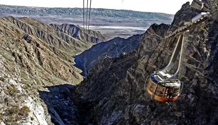
Flash flood closes Palm Springs Aerial Tramway for a week as monsoons slam California deserts
Gregory Yee – August 9, 2022
The Palm Springs Aerial Tramway, pictured in 2011, is scheduled to reopen Monday after a flash flood sent mud and debris into the area and stranded more than 200 people. (Luis Sinco / Los Angeles Times)
A flash flood that stranded more than 200 people on the Palm Springs Aerial Tramway on Monday in California’s latest bout of heavy summer rainfall is expected to close the attraction for a week.
Citing extended cleanup efforts, officials said the tramway is scheduled to reopen next Monday.
“After completing a thorough inspection earlier today, we realized that it would take additional days for the mud and debris to be fully removed from our equipment and dock area,” said Nancy Nichols, the tramway’s general manager. “We sincerely regret the inconvenience this is causing our visitors and appreciate their understanding.”
The National Weather Service in San Diego had warned that storms developing in the mountains and deserts Monday afternoon were becoming more numerous and could lead to torrential rainfall.
In a preliminary local storm report published Tuesday morning, the weather service said 1.99 inches of rain fell at San Jacinto Peak around 4 p.m. Monday, causing “impassible mudflows along the exit road from the Valley Station.”
The mudflows temporarily stranded more than 200 people on the tramway, the weather service said. The flow appeared to be mostly mud and not debris.
This week’s flooding followed a series of recent monsoonal downpours in California’s deserts and mountain areas.
Death Valley National Park was closed after 1.46 inches of rain fell in a few hours Friday, nearly 75% of the park’s average annual rainfall. About 1,000 people were trapped amid floodwaters and debris flows that uprooted trees, overturned boulders and sent parked cars colliding into one another.
Early last week, about 30 cars were stranded when heavy rain sent mud and debris onto Highway 38 leading to Big Bear, and flash flooding washed out parts of the Mojave National Preserve, closing most paved roads into the park.
Though monsoonal storms are not atypical at this time of year, climate change and rising global temperatures increase the chances that rainfall will be more intense when conditions are right for a storm, experts say.
“We’re already in a climate where the odds of intense precipitation are elevated,” climate scientist Noah Diffenbaugh, a professor and senior fellow at Stanford University, told The Times after the historic flooding in Death Valley. “And we have a clear understanding that as global warming continues, the heavy precipitation events are likely to continue to intensify overall.”
Searing Temperatures Across Europe Trigger Weather Warnings
Priscila Azevedo Rocha – August 9, 2022
(Bloomberg) — Another bout of extreme heat and dry weather set to sweep Europe has pushed the UK and France to issue fresh warnings for this week.
The UK Met Office warned of extreme heat in London and southeast England from Aug. 11-14, while the country’s Health Security Agency extended a heat-health alert that started on Tuesday for all regions until Aug. 14. The French state forecaster has a similar “extreme heat” amber warning out for parts of the south.
The forecasts cap a summer of extremely high temperatures across Europe, damaging infrastructure and raising the risk of droughts as the effects of climate change kick in. France registered the driest July on record and England the driest in almost 90 years. Water levels on the Rhine River, a vital artery for the transport of commodities and industrial goods, are so low that trade is at risk of coming to a halt on some sections of the waterway.
This week’s heat wave will not be as intense but longer than one earlier in the summer, staying around until the end of the week in the south of France, forecaster Meteo France said. Temperatures in Paris are expected to peak at 34.5 degrees Celsius (94.1 degrees Fahrenheit) on Friday, according to Maxar Technologies LLC.
Temperatures are expected to reach mid-30 degrees Celsius on Friday across South East England, London, the Southwest, and the East and West Midlands, the UK health agency said.
“Remember that heat can have a fast impact on health,” said Agostinho Sousa, head of extreme events and health protection at the agency. “It’s important to ensure that people who are more vulnerable – elderly people who live alone and people with underlying health conditions – are prepared for coping during the hot weather.”
Power prices in France and Germany reached record levels on Monday as low wind and heat-related restrictions at coal and nuclear plants boost demand for gas. That’s setting the stage for a more difficult winter as countries rush to store fuel.
Energy Rationing
The heat will boost demand for cooling, aggravating the already dry conditions that hurt crops and force limits on water use. In Spain, the government has moved to prevent offices and shops from setting air conditioning below 27 degrees Celsius in the summer in order to cut the country’s energy consumption.
Ireland issued a hot weather advisory from Wednesday through the end of the weekend. Temperatures are expected to reach the mid-to-high 20s Celsius — extremely warm for the country, which saw its highest temperature in over a century at 33 degrees last month.
The weather has also sparked fires near London, triggered warnings that railway lines could buckle, and forced power stations in Germany and France to operate at low levels to prevent overheating. The French nuclear regulator has granted a temporary waiver for five nuclear plants to discharge hot water into rivers that may breach environmental standards, an extreme measure to ensure there’s enough electricity.
German state forecaster DWD warned that in some areas there is a very high risk of forest fires. Data from late July shows that 45% of European Union countries are facing drought warning conditions and 15% are at alert levels, the European Drought Observatory says.
(Updates with UK Health Security Agency alert from second paragraph.)
Helen Briggs – Environment correspondent – August 9, 2022
Environmental groups say the prolonged dry spell is having a “serious” impact on wildlife in rivers.
With rivers already under pressure from pollution and use for drinking water, they say the looming drought is adding to the strain.
Chalk streams, which support iconic species such as the salmon, kingfisher and otter, are of particular concern, according to the Rivers Trust.
Only 200 exist globally, 85% of which are in southern and eastern England.
“This is our Barrier Reef or our Amazon rainforest; it’s our unique contribution to global wildlife and biodiversity,” said Christine Colvin of the Rivers Trust.
She said some small chalk streams were starting to dry up, while larger rivers were experiencing low flows.
“The wildlife here is already stressed as a result of the hotter temperatures and their habitat is shrinking as the water levels are getting lower and lower,” she added. “We don’t want them to go any lower than they are now.”
Jamie Marsh, reserves manager for the Hampshire and Isle of Wight Wildlife Trust, warned of “a serious situation” for wildlife as rivers run low in parts of the region.
At one nature reserve on the banks of the River Itchen in Winchester, a pond has completely dried up, while low river flow is hitting food sources for fish, insects and invertebrates, with knock-on effects for animals higher up the food chain such as water voles and otters.
“Our water resources are under a lot of pressure and this long period of drought is exacerbating those issues,” he said.
“What we can do to help is we as a society can look at our water consumption and try and reduce down our consumption.
“For many of our rivers, they’re not in a natural state; they’ve been heavily modified and engineered. Many of our river systems are acting more like drains than actual rivers now.”
A dried-up pond at the Winnall Moors Nature Reserve in Winchester
Chalk streams and rivers rise from springs in chalk bedrock – a layer of spongy rock found beneath much of southern and eastern England, that can hold vast quantities of water.
This layer of white limestone is composed of the same material that makes up the white cliffs of Dover and supplies water for rivers and taps in much of the south east of England.
Water is pumped out of the ground or taken directly from rivers, to the tune of millions of litres a day.
Southern Water, which supplies water to Hampshire and the Isle of Wight, said the decision to introduce a hosepipe ban was a “vital step” to protect the habitats of the River Test and the River Itchen, where it extracts water.
The company has said river flows were about 25% lower than they should be for July.
Algae blooms are appearing on lakes during the hot weather
And according to the latest projections by scientists, river flows are expected to remain exceptionally low in central and southern England for the rest of the summer.
Water UK, which represents the water industry, has said water companies with chalk streams in their regions have invested hundreds of millions of pounds in reducing and ending abstractions of water and further reductions will take place over the next few years.
However, the Rivers Trust has called for a total rethink in the way we use water to cope as dry hot summers likely become more frequent.
“We want to see government and the water companies responding in a coordinated way,” said Christine Colvin.
“This hot spell and this prolonged dry period is a pressure test for us now to get ready for the long haul because we’re going to be seeing many more summers like this in years to come.”
Mammals such as otters can struggle to find food if river levels run too low
Other wildlife is also struggling to find food during the long dry spell, including birds that feed on worms in the soil and ground-feeding mammals such as badgers.
Butterflies, solitary bees, hoverflies and insects may also be suffering as plants produce less nectar when they are experiencing water stress, said the Royal Horticultural Society.
Helen Bostock, RHS senior wildlife specialist said: “With many species of wild pollinator still in decline they need all the help they can get, but we can think of gardens as service stations for these pollinating insects. In a drought your garden might be the only reliable place a bumblebee or hoverfly can find water and nectar. “
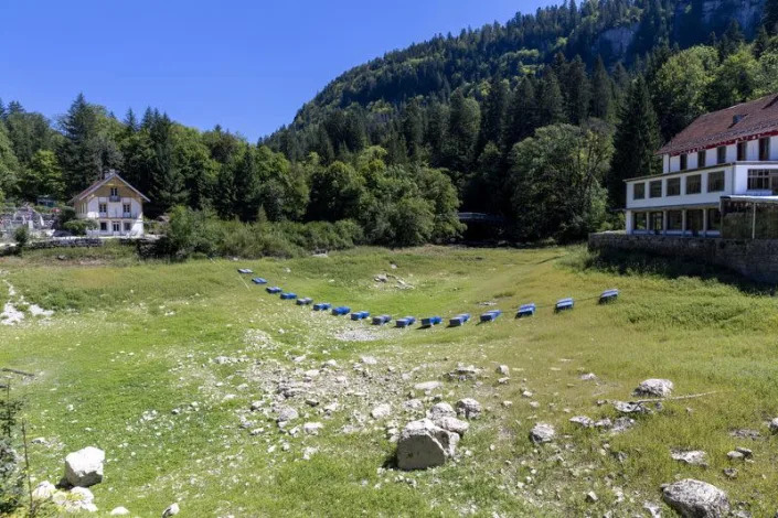
Tourist boats marooned, farm land parched as drought lowers Europe’s rivers
Denis Balibouse – August 9, 2022
Drought affected Doubs river in Arcon
VILLERS-LE-LAC, France (Reuters) – Business for Francoise Droz-Bartholet has reduced to a trickle, just like stretches of the Doubs River straddling the French-Swiss border that her cruise boats usually ply.
Water levels in rivers, lakes and reservoirs across western Europe are running low, or even dry, amid the severest drought in decades which is putting stress on drinking water supplies, hampering river freight and tourism and threatening crop yields.
The Doubs river should coarse through a forested canyon and cascade over waterfalls before spilling out into Brenets Lake, a draw for tourists in eastern France’s Jura region. After months without meaningful rain, the river water has receded up the canyon and sluggishly reaches the lake in a narrow channel.
“We hope this drought is an exception to the rule,” said Droz-Bartholet, whose bookings are 20% lower than usual for the time of year.
She now has to bus clients along the gorge to a starting point further upstream to a point in the river where there is enough water for her cruise boats to navigate.
Asked how his boat tour had gone, holidaymaker Alain Foubert said simply: “It was a lot shorter than normal.”
Conditions have deteriorated across Europe as multiple heatwaves roll across the continent.
In Spain, farmers in the south fear a harsh drought may reduce olive oil output by nearly a third in the world’s largest producer. In France, which like Spain has had to contend with recent wildfires, trucks are delivering water to dozens of villages without water.
In Germany, cargo vessels cannot sail fully loaded along the Rhine, a major artery for freight, and along Italy’s longest river, the Po, large sandbanks now bake in the sun as water levels recede sharply. In July, Italy declared a state of emergency for areas surrounding the Po, which accounts for more than a third of the country’s agricultural production.
As France contends with a fourth heatwave this week, many scientists say the blistering temperatures so far this summer are line with the increasing frequency and intensity of extreme weather episodes in Europe.
Britain’s weather service on Tuesday issued an amber “Extreme Heat” warning for parts of England and Wales, with no respite in sight from hot dry conditions that have sparked fires, broken temperature records and strained the nation’s infrastructure.
On the Doubs River, fewer boat tourists means fewer meals to serve for restaurateur Christophe Vallier – a painful blow just as he hoped to recover from the COVID-19 downturn. And he sees little cause for hope in the future.
“All the Doubs experts say the river is getting drier and drier,” Vallier lamented.
(Reporting by Denis Balibouse; Writing by Richard Lough; Editing by Susan Fenton)
Britain Braces for Another Round of Scorching Temperatures
Derrick Bryson Taylor – August 9, 2022
Britain Braces for Another Round of Scorching Temperatures
LONDON — Weeks after recording its highest-ever temperature, Britain was preparing for another unsettling stretch of hot weather, as officials said an extreme heat warning would be in place for much of the southern half of England and parts of Wales from Thursday through the weekend.
Although meteorologists predicted that temperatures would be unpleasantly hot this week, they were not expected to be as extreme as those in July, when they reached above 40 degrees Celsius (104 Fahrenheit) in Britain for the first time. Because of the expected heat this week, the U.K. Health Security Agency issued a Level 3 heat-health alert for southern and central England until Sunday, and it advised more vulnerable populations to stay hydrated and to take the necessary steps to prevent their homes from overheating. Most homes in Britain lack air-conditioning.
The heat was forecast to build throughout the week, peaking Friday and Saturday, according to the Met Office, Britain’s national weather service. Areas across central and southern England could reach up to 35 degrees Celsius (95 Fahrenheit). Other parts of England, Wales and Scotland could see the mercury rise to 29 degrees Celsius (84 Fahrenheit). Similar conditions were expected in Northern Ireland.
“What the July heat wave had was this kind of southern spike toward record-breaking temperatures, really with days of really extreme heat temperatures, where this week is more of a prolonged spell of temperatures, but not quite as hot,” Stephen Dixon, a spokesman for the Met Office, said Tuesday by phone.
“There are potential impacts from prolonged heat of this nature,” he said. “I think it’s important to note that nighttime temperatures for some areas in the south won’t drop below” 20 degrees Celsius (68 Fahrenheit).
Scattered thunderstorms could bring a bit of rain across the southwest and into some central areas Sunday, Dixon said, adding that there was a chance for more rain next week.
There were also concerns that the hot weather could affect transportation, with at least one official from Britain’s National Highways advising motorists to thoroughly check their vehicles before setting out.
Pets may also struggle with the heat, another official said, adding that pet owners should look after their animals with fresh drinking water, good ventilation and shade from direct sunlight.
Last month was the driest July in England since 1935, as the country received only 35% of its average monthly rainfall, according to the Met Office. On Tuesday, the BBC reported that Thames Water, which serves 15 million customers in southern England, including London, was planning to temporarily ban the use of hoses to water yards and gardens and to wash vehicles. It would be the third such ban in England this year.
Also because of intensely dry conditions, fire officials in Cornwall, in southwestern England, said Monday that there was a very high to exceptional risk of wildfire in the region and they urged residents to avoid starting bonfires and burning garden waste, as these actions could get out of control.
The heat wave across Britain in July was worsened by climate change, according to a scientific report. While tying a single heat wave to climate change requires analysis, scientists have no doubt that heat waves around the world are becoming hotter, more frequent and longer lasting. As the burning of fossil fuels causes average global temperatures to increase, the range of possible temperatures moves upward, too, making sizzling highs more likely. This means every heat wave is now made worse, to some extent, by changes in planetary chemistry caused by greenhouse-gas emissions.
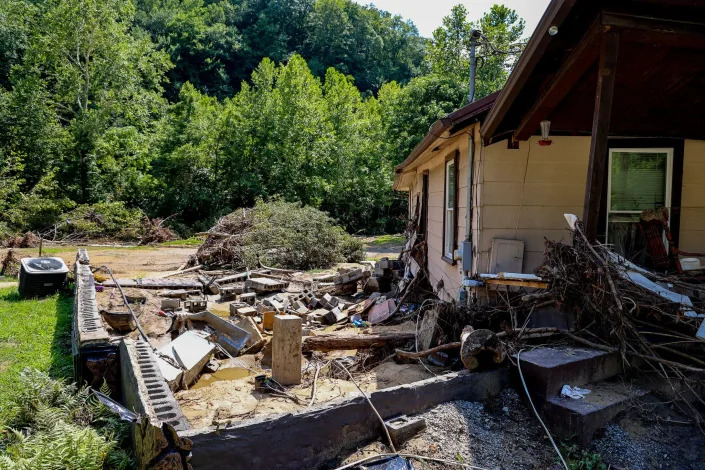
‘I can’t do it again’: Can Appalachia blunt the devastating impacts of more flooding, climate change?
Chris Kenning, Connor Giffin, James Bruggers – August8, 2022
JACKSON, Ky. – Teresa Watkins worked to salvage a few mud-caked belongings from her home on a Breathitt County branch of the Kentucky River after floods slammed her neighborhood July 28for the second time in 17 months.
The 54-year-old, who has lived off Quicksand Road since she was a teenager, said the flooding in recent years – “more and more, worse and worse” – has left difficult dilemmas in a county where median household incomes of $29,538 areless than half the national average.
She pointed to a mobile home one family abandoned last year. More say they’re leaving for safer areas, she said, but it’s not that easy.
“I don’t know how they can afford it or where they’re going to go. Any property is basically along the river line or creek banks,” she said. “And if they go up on the mountains, the mountains slide.”
Devastating floods that killed at least 37 people in Kentucky and damage in other parts of Appalachia, including Virginia and West Virginia, raise urgent questions about how to mitigate the impact of hazardous flooding that is likely to increase as climate change leads to more extreme weather.
In one of America’s most economically depressed regions, there are few easy answers.
The region’s mountainous landscape, high poverty rates, dispersed housing in remote valleys, coal-mining scars that accelerate floods and under-resourced local governments all make solutions extremely difficult.
Teresa Watkins, 54, salvages belongings from her flood-damaged home outside Jackson, Ky.
Measures such as flood wells, drainage systems or raising homes are expensive for cash-strapped counties. Buyouts or building restrictions are difficult in areas where safer options and home construction are limited. Many are unable or unwilling to uproot.
Tamping down extreme weather by reducing climate-changing emissions nationwide is a goal that is politically fraught, including in a region with coal in its veins, and promises no quick relief.
“If we had all the money in the world, and we had the political will and cooperation, we could go a long way towards solving these problems,” said Bill Haneberg, director of the Kentucky Geological Survey and a professor of Earth and environmental sciences at the University of Kentucky.
Even as Kentucky’s devastation renews attention to long-standing challenges, some residents said they have little hope that effective protections will arrive anytime soon.
The emphasis is on trying to rebuild what was lost.Kentucky Gov. Andy Beshear said he may call a special legislative session for more aid to the region, and the Federal Emergency Management Agency provides housing and other help.
In Pilgrim’s Knob, Va., Sherry Honaker, 55, oversees the removal of debris from her niece’s home on Dismal Creek. It was gutted in a major flood, the county’s second this year.
Repeat floods have prompted some officials to search for longer-term answers. Buchanan County, Virginia, for example, is drawing up a plan to identify projects to blunt flooding’s impact. Those projects would still have to be paid for.
Some residents are fatalistic or doubt the government can do much. Others push for more protections in areas where many have few options to move and can’t afford flood insurance.
In the Buchanan County community of Pilgrim’s Knob, Sherry Honaker, 55, watched crews remove debris from her niece’s home on Dismal Creek. It was gutted in a major flood about two weeks before the Kentucky floods – the county’s second this year.
“Something needs to be done,” she said.
How susceptible is Appalachia?
Central Appalachia is no stranger to flooding. The latest high water in eastern Kentucky broke records, and experts expect more to follow.
Amid the larger pattern of extreme weather in the USA, from wildfires to heat waves, meteorologists and climate scientists say human-driven climate change comes with a warmer atmosphere capable of holding more moisture.
That can mean more bouts of intense rainfall, and more rain in a short period fuels flash flooding, said Antonia Sebastian, an assistant professor at the University of North Carolina at Chapel Hill specializing in flood resilience and mitigation.
The region’s topography contributes to how “flashy” a flood can be, Sebastian said.
The steep slopes of the Appalachians allow water to rush quickly into the narrow valleys, sometimes swamping hollows before residents have a chance to escape.
Flooding damaged a church in Breathitt County, Ky.
In 2019, an Inside Climate News analysis of U.S. Army Corps of Engineers stream flow data and satellite images of disturbed land from strip mining found areas such as the Big Sandy watershed, which straddles the Kentucky and West Virginia state line, to be among the most threatened by climate-change-drivenextreme weather within the Ohio River Basin.
The region’s history of coal mining, as well as logging, can exacerbate flooding, experts said, by altering the landscape.
In surface mining, trees are the first to go, then sometimes hundreds of feet of rock are blasted away from the tops and sides of mountains to get at underground seams of coal.
“Normally, on a forested hillside, the trees and their roots will absorb 40% to 50% of the rain that falls, then slowly release it,” said Jack Spadaro, a former top federal mine safety engineer. After mining, surfaces robbed of vegetation facilitate flash flooding, he said.
An area strip mined from 1985 through 2015 is superimposed on the Army Corps of Engineers’ forecast for stream flows. The area with the most land disturbance from mining could see the biggest increase in stream flows from climate change.
Housing patterns contribute to the area’s vulnerability. Many residences are scattered in smaller communities along a road that often winds along a creek lined with steep hillsides.
In Kentucky’s Breathitt County, half of all homes are at a high risk of flooding, according to data provided to USA TODAY by the First Street Foundation, a research and technology nonprofit that tracks flood risks.
The same is true of 46% of homes in the state’s Perry County and 58% in Letcher County.
“You hear people say, ‘Oh, you know, they shouldn’t live in a flood plain. They should move someplace else.’ But if you look at a lot of these towns, there are really not a lot of good options,” Haneberg said.
Added to that is the area’s economic vulnerability. Many residents cannot afford flood insurance.
ATV drivers ferry generator fuel and water around Jessica Willett’s home in Bowling Creek, Ky. Flooding tore it from its foundations and left it in the middle of the road.
Amid coal’s decline, good jobs are hard to find. Breathitt County’s poverty rate is 28%, more than twice the national rate of 11%. The median home value of $53,000 is less than a quarter of the national average, according to the U.S. Census Bureau.
The region has higher rates of chronic disease, and populations have fallen in recent decades.
Jessica Willett, 34, whoseremote Jackson homewas pushed downstream by floodingwhile she and her two children were inside, said she was nervous about rebuilding on Bowling Creek.
But she doesn’t want to leave her home.
“My aunt down the road, she is going to move. She lost everything,” she said. “It’s just hard because down here, there’s a lot of family land. We want our kids and grandkids to grow up on it.”
The ‘pain points’ of climate change
Standing near Dismal Creek in Virginia, Honaker looked over a giant pile of rubble. She said she wants officials to ramp up unclogging draining culverts or increasing the creek’s depth.
She looked at her niece’s home: “Maybe stilts would have helped,” she said.
Though it’s impossible to halt heavy rains and flooding, counties and towns can consider measures to limit their impact, said Tee Clarkson, a principal at First Earth 2030, a company helping Buchanan County develop its flood resiliency plan.
That could include flood walls, strengthening creek banks, dredging creeks to greater depths and expanding piping and drainage systems, he said. Houses could be raised on stilts.
A flood lifted a home in Pilgrim’s Knob, Va., from its foundation.
“It’s hard to keep areas from flooding, but you want to lower the pain points” for residents and infrastructure, he said.
U.S. Rep. Hal Rogers, a Republican who represents eastern Kentucky, said that in an area with a “long and daunting history of flooding,” he helped secure more than $800 million over 40 years to help build flood walls, levees, tunnels and other public safety projects.
“However, this flash flood was a natural disaster that turned small creeks and mountain runoff into raging rivers that charted a new destructive course through our valleys and hollows,” he said. “These types of floods have always been one of the greatest challenges to mitigate in the mountains, and I will continue to advocate for every possible resource that we can afford to protect our mountain communities.”
What could help, experts said, is tackling the hundreds of thousands of acres of former mine land in Appalachia still to be reclaimed, according to a report in 2021 by the environmental group Appalachian Voice.
Counties can restrict building or add stricter building requirements, but that is easiest for new construction – in Perry County, Kentucky, few new building permits were issued in recent years, according to the U.S. Census Bureau.
Perry County Judge-Executive Scott Alexander said he looks for ways to make his county more flood-resilient, such as raising bridges or expanding reservoirs. He said a discussion might include raising homes in flood-prone areas.
“We’ve got to start looking at preventive flooding measures,” he said. He cautioned that “when you get to 12 inches of rain, especially in Appalachia, there’s not a whole lot of anything that can handle that.”
Flooding left a refrigerator covered in river mud in Teresa Watkins’ home outside Jackson, Ky.
FEMA buyouts have been an option, but they take time and can be fraught with potential harm, Sebastian said. The central Appalachian population is one of the poorest in the country and moving that population out of a region with a generally low cost of living could bring further economic hardship.
The properties in the most flood-prone areas tend to be the most affordable, further endangering the very poorest Appalachians, said Colette Easter, president of Kentucky’s section of the American Society of Civil Engineers.
“That involves gut-wrenching questions about moving away from a place that you’ve lived for a very long time, maybe generations, and you’re very connected to,” Eric Dixon, a researcher at the Ohio River Valley Institute, said with a deep sigh. “But maybe you don’t have another choice. Maybe that’s literally what you have to do. That’s the real heartbreaking part of this, I think.”
Flooded residents, to choices
For 15 years, Angie Rosser has lived along the Elk River in Clay County, West Virginia.
In 2016, a powerful flood hit the state, killing 23 people and causing more than $1 billion in damage.
Six years later, Rosser said her community still doesn’t have a grocery store. She hasn’t replaced much of the furniture she lost. In Rosser’s house, you’ll find a bed but no couch and no dining table.
“My house is pretty empty, because I am expecting another flood to happen – which is not a great way to live,” said Rosser, executive director of the West Virginia Rivers Coalition.
Rosser understands the commitment to stay and rebuild shared by many of her neighbors, but “I’m not one of those people,” she said. “If it floods again, I’m out. I can’t do it again. It was just too exhausting.”
That same weary uncertainty has spread across hard-hit counties in Kentucky this week, where the next disaster lurks behind each heavy rainfall to come.
Dee Davis was a Hazard, Kentucky, kindergartner when a flood devastated the area in 1957. It is seared into his memory. He recalls his grandmother and great-uncle taking a canoe to buy groceries.
“We lost everything,” he said.
That flood 65 years ago set a record water level for the North Fork Kentucky River, at 14.7 feet in Whitesburg. Locals never forgot the damage it wrought.
The most recent flooding put that same river at about 21 feet. The water rushed in with enough force to destroy the U.S. Geological Survey sensor designed to monitor the water level.
On Whitesburg’s Main Street this week, the stuffy odor of mud lingered everywhere. The sidewalks were littered with growing piles of discarded furniture, rubble and children’s toys.
The path ahead starts by reckoning with what was lost.
“You mourn the dead,” Davis said, “and you find a way to go forward.”
Study connects climate hazards to 58% of infectious diseases
Seth Borenstein – August 8, 2022
Climate hazards such as flooding, heat waves and drought have worsened more than half of the hundreds of known infectious diseases in people, including malaria, hantavirus, cholera and anthrax, a study says.
Researchers looked through the medical literature of established cases of illnesses and found that 218 out of the known 375 human infectious diseases, or 58%, seemed to be made worse by one of 10 types of extreme weather connected to climate change, according to a study in Monday’s journal Nature Climate Change.
The study mapped out 1,006 pathways from the climate hazards to sick people. In some cases, downpours and flooding sicken people through disease-carrying mosquitos, rats and deer. There are warming oceans and heat waves that taint seafood and other things we eat and droughts that bring bats carrying viral infections to people.
Doctors, going back to Hippocrates, have long connected disease to weather, but this study shows how widespread the influence of climate is on human health.
“If climate is changing, the risk of these diseases are changing,” said study co-author Dr. Jonathan Patz, director of the Global Health Institute at the University of Wisconsin-Madison.
Doctors, such as Patz, said they need to think of the diseases as symptoms of a sick Earth.
“The findings of this study are terrifying and illustrate well the enormous consequences of climate change on human pathogens,” said Dr. Carlos del Rio, an Emory University infectious disease specialist, who was not part of the study. “Those of us in infectious diseases and microbiology need to make climate change one of our priorities, and we need to all work together to prevent what will be without doubt a catastrophe as a result of climate change.”
In addition to looking at infectious diseases, the researchers expanded their search to look at all type of human illnesses, including non-infectious sicknesses such as asthma, allergies and even animal bites to see how many maladies they could connect to climate hazards in some way, including infectious diseases. They found a total of 286 unique sicknesses and of those 223 of them seemed to be worsened by climate hazards, nine were diminished by climate hazards and 54 had cases of both aggravated and minimized, the study found.
The new study doesn’t do the calculations to attribute specific disease changes, odds or magnitude to climate change, but finds cases where extreme weather was a likely factor among many.
Study lead author Camilo Mora, a climate data analyst at the University of Hawaii, said what is important to note is that the study isn’t about predicting future cases.
“There is no speculation here whatsoever,” Mora said. “These are things that have already happened.”
One example Mora knows firsthand. About five years ago, Mora’s home in rural Colombia was flooded — for the first time in his memory water was in his living room, creating an ideal breeding ground for mosquitoes — and Mora contracted Chikungunya, a nasty virus spread by mosquito bites. And even though he survived, he still feels joint pain years later.
Sometimes climate change acts in odd ways. Mora includes the 2016 case in Siberia when a decades-old reindeer carcass, dead from anthrax, was unearthed when the permafrost thawed from warming. A child touched it, got anthrax and started an outbreak.
Mora originally wanted to search medical cases to see how COVID-19 intersected with climate hazards, if at all. He found cases where extreme weather both exacerbated and diminished chances of COVID-19. In some cases, extreme heat in poor areas had people congregate together to cool off and get exposed to the disease, but in other situations, heavy downpours reduced COVID spread because people stayed home and indoors, away from others.
Longtime climate and public health expert Kristie Ebi at the University of Washington cautioned that she had concerns with how the conclusions were drawn and some of the methods in the study. It is an established fact that the burning of coal, oil and natural gas has led to more frequent and intense extreme weather, and research has shown that weather patterns are associated with many health issues, she said.
“However, correlation is not causation,” Ebi said in an email. “The authors did not discuss the extent to which the climate hazards reviewed changed over the time period of the study and the extent to which any changes have been attributed to climate change.”
But Dr. Aaron Bernstein, interim director of the Center for Climate, Health, and the Global Environment at Harvard School of Public Health, Emory’s del Rio and three other outside experts said the study is a good warning about climate and health for now and the future. Especially as global warming and habitat loss push animals and their diseases closer to humans, Bernstein said.
“This study underscores how climate change may load the dice to favor unwelcome infectious surprises,” Bernstein said in an email. “But of course it only reports on what we already know and what’s yet unknown about pathogens may be yet more compelling about how preventing further climate change may prevent future disasters like COVID-19.”
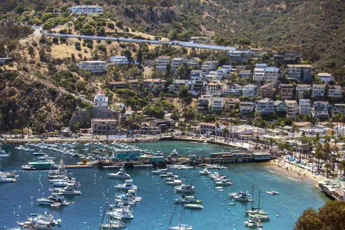
Saltwater toilets, desperate wildlife: Water-starved Catalina Island battles against drought
Hayley Smith – August 5, 2022
Raymond Valdez, 8, pours cool seawater on his head to rinse off the sand at the beach in Avalon. (Francine Orr / Los Angeles Times)
Island-dweller Lori Snell grimaced as she tallied her bill recently at the Avalon Laundry — nearly $50 for three large loads.
“It’s always an adventure to live in Catalina,” said Snell, 64. “It’s a joy, it’s a paradise, it’s a challenge.”
For Snell and Santa Catalina Island’s other 4,000 full-time residents, water is a bit of an obsession. When you live an hourlong ferry ride from Long Beach, a gallon of the stuff can cost six times more than it does “over town” — the islanders’ term for the mainland.
That preoccupation with water has now become critical as severe drought grips California and its Channel Islands — a rugged, eight-isle archipelago that hosts several human outposts and a handful of species that exist nowhere else on Earth.
But although some of the island’s wildlife is struggling for survival, conditions for humans are a little different today than in droughts past, due largely to a desalination plant that opened in Avalon in 2016. The plant today provides about 40% of Avalon’s drinking water.
“Over town, you’re not affected by drought as much as you are here,” said Snell, a former resident of Encino. “All the locals and businesses are very aware. Our ability to live here depends on us having fresh water.”
Conditions on Catalina Island are a little different this time around, thanks in large part to a desalination plant that opened in Avalon at the end of the last drought. (Francine Orr / Los Angeles Times)
Many Avalon residents still have vivid memories of the state’s last punishing drought, which forced them into severe Stage 3 water restrictions at the end of 2016.
Things got so bad that even some fine-dining restaurants switched to paper plates to avoid running dishwashers, and hotels ferried their linens to the mainland for laundering in an effort to cut costs and conserve tight supplies, several locals said.
But desalination has helped keep them out of similarly severe water restrictions so far this year, according to Ronald Hite, senior manager of Catalina Island for Southern California Edison, the island’s water provider.
“We run desal 100% of the time and rely on it, and then supplement with groundwater,” Hite said. “That’s bought us a year, and taken us really from the front of the line — where we were last time, going into drought restrictions and rationing — to the back of the line, which is fantastic.”
Although desalination provides potable water to Catalina’s humans, it can’t do quite as much to help the island’s wildlife, including bison, amid the worsening drought. (Francine Orr / Los Angeles Times)
Indeed, although most of mainland Los Angeles moved into Stage 3 restrictions at the start of June, Avalon in July crept into only Stage 1, even as its reservoir dropped about 100 acre-feet in the last three months. Hite said it’s a remarkable feat for an island that has no access to state or federal water supplies, and which for decades relied primarily on its reservoir to supply full-time residents and roughly 1 million visitors each year.
“This is different this time — we’re actually in a much better spot than our peers elsewhere,” he said. “And the main driver of that is that we are using every drop of our drought-resistant resources that we possibly can. … We might be facing mandatory rationing right now had we operated the system like we used to.”
That’s not to say water is taken for granted on Catalina, where conservation has largely become a way of life. According to Hite, residents use an average of 57 gallons per day — about half of the residential average in the area served by the Los Angeles Department of Water and Power. What’s more, there are very few lawns that require water, and most homes have saltwater toilets that keep them from flushing freshwater down the drain.
Gregg Miller, who owns Avalon’s Hotel Metropole and Market Place, which includes several restaurants and the laundromat, said he’s spent the last four years converting most of the hotel’s bathtubs into showers in order to save water. He also got rid of all their hot tubs.
“It’s such an ongoing situation,” Miller said of drought. “It never gets quite resolved, so you’re always really doing things that you hope will save some water. It’s a challenge.”
Scooping cups of water from a bucket rather than using a hose, a woman cleans the sidewalk outside the Hotel Atwater in Avalon. Water is not taken for granted on the island. (Francine Orr / Los Angeles Times)
And although he said it can be “hard to tell people paying $300 a night, ‘Don’t take a long shower,’ ” the new desalination plant has helped give everyone some breathing room.
“To some degree, the desal plant has taken a little bit of the pressure off,” Miller said. “Because unlike most other places, we don’t have any secondary source, another municipal district that could lend us water or share water with us. We have only what we have in our reservoirs and a few small wells.”
The message hasn’t necessarily registered with all of the island’s visitors, including the thousands of tourists who arrive each week via cruise ships and those who take the ferry from L.A., Long Beach and Orange County.
Phil and Cheryl Gaston, who were visiting from Georgia, said they were aware of the drought conditions plaguing the West but that it hadn’t really factored into their plans to visit the island.
“If I had been planning a vacation in Lake Mead, though, I wouldn’t go,” said Phil Gaston, 66.
Visitors enjoy snorkeling and scuba diving lessons in Avalon. (Francine Orr / Los Angeles Times)Alex Romero manages the burger-and-dog outpost Coney Island West in Avalon. He recently converted the restaurant’s three-compartment sink into two compartments to help save water. (Francine Orr / Los Angeles Times)
Alex Romero, a 40-year resident of Avalon who runs and owns the burger-and-dog outpost Coney Island West, said that “it would be nice if [tourists] would be more conscious — their long showers really kill us.” But he also added that visitors are the lifeblood of the island and essential to the residents’ way of life. “They’re what keep us going.”
Romero recently converted the restaurant’s three-compartment sink into two compartments to help save water, he said. And instead of hosing down the patio nightly, he’s doing it once a week and using a mop the rest of the time.
“The reservoir and desal help, but we need rain this year for sure,” he said. “If not, it will get a lot worse.”
Desalination is also not without controversy. In May, plans for the massive Poseidon plant in Huntington Beach were rejected by the California Coastal Commission due to concerns about high costs, ecological hazards and other significant hurdles. The desalination process, which typically includes the discharge of hypersaline brine back into the ocean, has been criticized for negatively affecting marine life near facilities, as well as high energy consumption.
Hite, the Edison manager, said many of those effects have been mitigated at the Avalon plant because of its relatively small scale. Although the Poseidon plant would have produced up to 50 million gallons of drinking water a day, the facility in Avalon produces about 240,000.
Ava Jessie McDonald, a water and gas operator mechanic at Southern California Edison, checks the numbers on the control panel inside the desalination plant in Avalon. (Francine Orr / Los Angeles Times)
“We’ve got a couple things going for us here in terms of desal production in that number one, we are surrounded by water so we have easy access to it, and number two, we’re relatively small scale,” he said. “It’s much less of an impact for someone like us than for, say, a giant plant such as those that have been proposed recently.”
According to the most recent monitoring report submitted to state regulators, salinity levels from the plant are relatively low, around 50 parts per thousand at the discharge point and 30 to 35 parts per thousand at various depths and distances from the facility. Average ocean salinity, broadly speaking, is about 35 parts per thousand.
Hite said the reverse-osmosis plant, which is diesel-powered, also uses the high-pressure reject water to help turn its pump, enabling it to use a smaller motor and reduce electrical consumption. Edison is currently seeking a grant for a new deepwater well that would allow it to bring an older desalination facility on the island, built in the 1990s, back online, he said.
Yoram Cohen, a desalination expert and professor of chemical and biomolecular engineering at UCLA who is not affiliated with the Avalon plant, said size can be a factor when it comes to the impact of the brine.
“If you discharge 20, 25 million gallons a day, that’s a lot more than 200,000 gallons a day,” he said, “so the impact on the environment, the local impact, is going to be very different. It may be easier to disperse a small volume, or a small volumetric flow, than it is a huge one.”
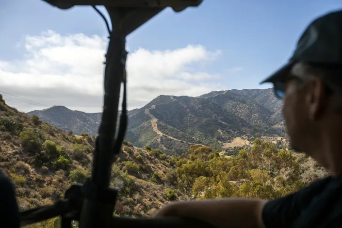
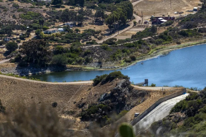
Visitors take a two-hour “eco-tour” with the Catalina Island Conservancy in Avalon. They explore parts of the island’s interior to see plants, landscape and wildlife, including bison. (Francine Orr / Los Angeles Times)The water level at the Middle Ranch Reservoir in Avalon dropped 100 acre-feet in the last three months. (Francine Orr / Los Angeles Times)
Cohen said recent studies from Australia, Israel, Singapore, Saudi Arabia and other places using desalination have also shown that discharge “should not have an adverse impact” if it is done properly. But although desalination can be a helpful tool — especially for areas near the coast — it shouldn’t be the only source of supplies, he said.
“Desal alone is not going to solve the problem, but it’s an added component of our water portfolio,” Cohen said. “At the end of the day, I think that we have to keep our water portfolio diversified, just like you would keep your money invested in multiple places. You want to be safe, right? You don’t put your money in one investment.”
There are other challenges too. Many residents are now fighting a proposed rate hike by Edison that they say will make their already-pricey water even more expensive. The agency said the increase will help recoup some losses from the last drought and keep the systems running.
“Desal is not an inexpensive operation,” Avalon Mayor Anni Marshall acknowledged. She said the island’s small number of ratepayers also drive up the costs because there are fewer people to share the expense. “But I think the trade-off is, we love living here and we’re willing to sacrifice as much as we can — or as much as we have to.”
Thousands of tourists arrive each week in Catalina via cruise ships and ferries from L.A. (Francine Orr / Los Angeles Times)
Marshall said she wants the island to work toward new groundwater capture and water recycling projects in the near future. But she also noted that because most homes use saltwater toilets and don’t have frontyards, the significant 50% savings residents achieved during the last drought were hard-won.
“That large reduction we did was basically personal consumption — it was in our showers, washing dishes and that kind of thing,” she said.
The mindset is apparent all around the town, where beachgoers this week rinsed off under saltwater showers and restaurants declined to provide tap water, offering only bottles. One woman was spotted cleaning the sidewalk with a bucket and a cup, carefully doling out one splash at a time. For many, including Marshall, it’s a success story.
“It’s amazing,” she said. “The situation we’re in now is nothing compared to what it was in the previous drought.”
The water level of water at the Middle Ranch Reservoir on Catalina Island is down due to the current draught. (Francine Orr / Los Angeles Times)
But although desalination is keeping Catalina’s humans supplied with potable water, it can’t do quite as much to help the island’s flora and fauna amid worsening drought.
The famed Catalina Island fox, as well as the island’s non-native deer and bison, are “suffering mightily” due to the lack of moisture, which is tied closely to their food supply, according to Deni Porej, senior conservation director with the Catalina Island Conservancy. Lately, he said, deer have been appearing on the island’s golf course in the evenings, when they know the sprinklers will turn on and provide them with a spot of relief.
What’s more, a combination of dry conditions, deer predation and pollination problems is threatening the island’s ancient ironwood trees, of which there are only about 120 left.
“Groundwater is hugely important to us, because a lot of the plants that we have here have very deep roots, and they tap into the groundwater,” Porej said, noting that for the ironwoods, “the issue of groundwater is a matter of life and death.”
A couple takes a break from the water fun in Avalon. (Francine Orr / Los Angeles Times)
“It’s a weird feeling when you’re standing in the grove and you’re looking at basically a species dying out. It’s kind of a gut punch,” he said.
Porej said he hoped to see island officials come together to develop a more comprehensive groundwater management plan, but he also credited the desalination plant with improving some of Catalina’s conditions.
“It’s helping, but it’s not the ultimate solution, because there’s always a need for more,” he said. “We will always be looking for opportunities to have more water on the island. That’s the limiting factor to our ecosystem, it’s the limiting factor to growth. Like many parts of California, it’s about gold and water.”