GM’s self-driving car arm will take driverless cars to Texas and Arizona this year
Jamie L. LaReau, Detroit Free Press – September 13,2022
General Motors’ self-driving car subsidiary Cruise is expanding beyond San Francisco as it drives toward a goal of $1 billion in revenue by 2025.
In June, Cruise started operating its self-driving taxi service in San Francisco where it charges for rides in Chevrolet Bolt EVs that operate without a human safety driver. Cruise uses a fleet of 30 Bolts to ferry the paying passengers around parts of the city. Those Bolts are currently built at Orion Assembly plant in Orion Township.
General Motors and Cruise got approval on June 2, 2022 to start operating self-driving ride hail taxis like this one in San Francisco for a fare.
Now the San Francisco-based Cruise, of which GM owns an 80% stake, will bring a driverless taxi-fleet to Austin, Texas, and Phoenix, Arizona, in the next three months, Cruise CEO Kyle Vogt said Monday.
Initially, Cruise’s operations in Austin and Phoenix will be small to generate revenue, with a plan to scale up operations next year, Vogt told an audience at a Goldman Sachs conference Monday, where he also said Cruise aims to hit $1 billion in revenue by 2025, said Cruise spokeswoman Tiffany Testo.
Cruise has obtained the appropriate permits to use the driverless cars for ride-hailing and deliveries in Phoenix where it has been operating a self-driving delivery service with Walmart for some time, Testo said. Cruise started the pilot for that delivery service in 2020 and expanded it last year. In April, Walmart announced it had become an investor in Cruise.
“We’ve made over 10,000 deliveries there in the past few months,” Testo said. “We’re starting from zero footprint but believe the strong technical foundation we built in San Francisco will enable us to quickly and safely scale.”
Cruise was the first commercial driverless taxi system in a major U.S. city. But Waymo opened a fully autonomous commercial ride hail service to the public in October 2020 in suburban Chandler, Arizona.
On Thursday, GM subsidiary BrightDrop said it too plans to offer self-driving electric commercial delivery vehicles in the future. During a webcast presentation at the Evercore ISI 2nd Annual Technology Conference, BrightDrop CEO Travis Katz said the company is “actively” looking at how to apply autonomous driving technology to its commercial trucks. He said GM’s connection to Cruise will give BrightDrop a competitive advantage when the times comes to apply autonomous technology to the commercial delivery market.
California’s drought touches everyone, but water restrictions play out unevenly across communities
Soudi Jiménez – September 13, 2022
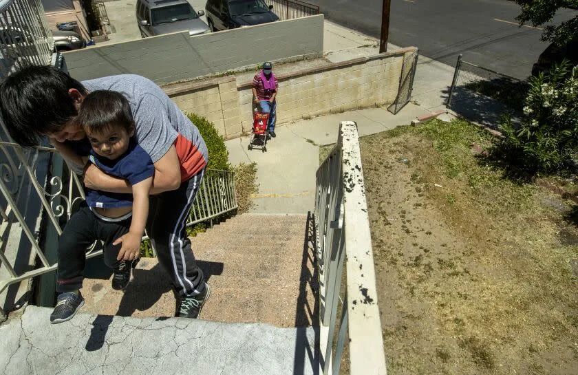
Benita Perez teaches her grandson, Nevaeh Perez, 1, how to walk at their apartment building in Lincoln Heights. Area at right, below used to be all grass until a year ago, because of the drought. (Mel Melcon/Los Angeles Times)
Raúl Monterroso of San Fernando knows that he can do little to help the struggling garden patio in front of his house. After all, he takes the new water restrictions seriously.
“Here, everything is dry, we have the entire irrigation system closed, my poor wife is crying over her plants,” said the Guatemala native, who stopped watering the grass on June 1 when instructions to cut outdoor watering to once a week were issued.
Further restrictions went into effect Sept. 6, when a 15-day ban through Sept. 20 was mandated by an emergency repair that shut down the 36-mile Upper Feeder pipeline that brings water from the Colorado River to Southern California. The Metropolitan Water District of Southern California said that more than 4 million people are being affected by the shutdown across the region, including Beverly Hills and Malibu, Burbank and Glendale, Long Beach, the city of Inglewood and a large swathe of the South Bay, and other areas stretching as far east as Pomona.
Also under the ban is the city of San Fernando, at the northern edge of L.A.’s San Fernando Valley, 92% of whose 24,000 residents are Latino.
“The reality is that when they give you the alert, you have to be aware. The measures must be followed, there is no other option,” Monterroso said.
In Long Beach, an hour’s drive south of San Fernando, businesswoman Sandy Cajas said that urgent measures are needed to maintain a steady flow of water and find new sources of it.
“We are experiencing the worst drought in decades,” she said. “What is going to happen here is that we are going to have to recycle the water due to the scarcity that exists.”
That’s one item, among many, on the state capital’s agenda. Last month, a 16-page document released by Gov. Gavin Newsom, “California’s Water Supply Strategy — Adapting to a Hotter, Drier Future,” indicated that California’s water supply will shrink 10% by 2040.
Among other measures, the plan, backed by billions of dollars in investment, calls for recycling more wastewater and desalinating seawater and salty groundwater, as well as speeding up infrastructure development and pushing conservation, in hopes of providing enough water for more than 8.4 million homes by 2040.
According to Newsom, this “aggressive plan” will guarantee that future generations “continue to call California home in this hotter, drier climate.”
“The best science tells us that we need to act now to adapt to California’s water future. Climate change means drought won’t just stick around for two years at a time like it historically has — extreme weather is the new normal here in the American West and California will adapt to this new reality,” Newsom said in an Aug. 11 statement.
Yet the drought is playing out unevenly across different communities and among different households. Since June 1, about 6 million residents in Los Angeles, Ventura and San Bernardino counties have had to limit outdoor water use to once a week. But not everyone is complying.
Every day since 2003, Álex Guzmán has driven a truck for work from the San Fernando Valley to Beverly Hills. The Mexican immigrant labors for a landscaping company. His task is to maintain the trees and lawns of the mansions. But, above all, to water lots and lots of plants.
Hearing that additional restrictions on water use have been implemented, Guzmán just smiles.
“We have never stopped working in Beverly Hills, we have never stopped watering mansion gardens because of the restrictions,” he said.
“We are working normally, the bosses have not told us anything about lowering the use of water,” Guzmán added.
As reported by The Times, celebrities such as Sylvester Stallone, Dwyane Wade, Kevin Hart, Kim and Kourtney Kardashian are among the more than 2,000 customers who have received “notices of exceedance” for surpassing 150% of their monthly water budgets at least four times since the Las Virgenes Municipal Water District declared a drought emergency in late 2021.
That disparity in following restrictions shows up in many public spaces, said Patty López, a former Assemblywoman for District 39, pointing for example to the contrast between the independent city of San Fernando and Sylmar, which is part of the city of Los Angeles.
“If you look at the Veterans Memorial Community Regional Park in Sylmar it is completely green, but in the parks in our area the grass is dead,” said López, a San Fernando resident, lamenting that there is no clear, consistent application of policies, or rigorous follow-up and enforcement, throughout the region.
Under current conditions, if the use of water is not controlled, worse consequences won’t be long in coming.
Samuel Sandoval Solís, professor of water resources management at UC Davis, said that California has 30% of its water stored in dams, meaning that, because of the drought’s effects, 70% of its capacity is gone. Water level in the subsoil has dropped 25 feet since 2016.
“Everything is looking very bad,” said the academic, who has been researching, monitoring and teaching on the subject of water for 20 years.
According to a UC Berkeley study, as temperatures in California rose between 1960 and 1980, rainfall also diminished, based on climatological records and analyzing the cores of trees.
Given the current scarcities of water, and recent extreme heatwaves across the Golden State, even downpours in the upcoming rainy season wouldn’t be enough to compensate, Sandoval Solís said.
“It’s not enough to make it to the next year,” he said.
Sandoval Solís said that if Californians don’t do more to conserve water, the authorities will have to implement restrictions such as those imposed on some municipalities during a previous drought phase between 2014 and 2016. Those restrictions limited the amount of gallons per person to between 12 and 15 daily.
According to the California Dept. of Water Resources, the “current statewide median indoor residential water use is 48 gallons per capita per day, and that a quarter of California households already use less than 42 gallons per capita per day.” The U.S. Environmental Protection Agency website states that each American uses an average of 82 gallons per day at home, including consumption.
“We need to raise awareness that we must all enter this equally,” Sandoval Solís said, “regardless of whether you live in a luxury house or in an apartment, we all have to reduce water consumption.”
In Arizona, worry about access to Colorado River water
Tony Davis – September 13, 2022
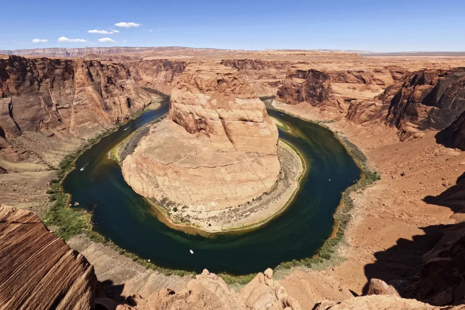
Utah State University master’s student Barrett Friesen steers a boat near Glen Canyon dam on Lake Powell on June 7, 2022, in Page, Ariz. In Arizona, water officials are concerned, though not panicking, about getting water in the future from the Colorado River as its levels decline and the federal government talks about the need for states in the Colorado River Basin to reduce use. (AP Photo/Brittany Peterson, File) The Colorado River flows at Horseshoe Bend in Glen Canyon National Recreation Area, Wednesday, June 8, 2022, in Page, Ariz. In Arizona, water officials are concerned, though not panicking, about getting water in the future from the Colorado River as its levels decline and the federal government talks about the need for states in the Colorado River Basin to reduce use. (AP Photo/Brittany Peterson, File) Water from the Colorado River diverted through the Central Arizona Project fills an irrigation canal, Aug. 18, 2022, in Maricopa, Ariz. In Arizona, water officials are concerned, though not panicking, about getting water in the future from the Colorado River as its levels decline and the federal government talks about the need for states in the Colorado River Basin to reduce use. (AP Photo/Matt York, File)New home construction encroaches dormant fields owned by Kelly Anderson, left, Aug. 18, 2022, in Maricopa, Ariz. Anderson grows specialty crops for the flower industry and leases land to alfalfa farmers whose crops feed cattle at nearby dairy farms. (AP Photo/Matt York, File)Boats move along Lake Powell along the Upper Colorado River Basin, June 9, 2021, in Wahweap, Ariz. In Arizona, water officials are concerned, though not panicking, about getting water in the future from the Colorado River as its levels decline and the federal government talks about the need for states in the Colorado River Basin to reduce use. (AP Photo/Ross D. Franklin, File) Tourists carry a kayak up a sandy hill Tuesday, June 7, 2022, in Page, Ariz. As Lake Powell levels drop, recreation is becoming tougher to access as boat ramps and marinas close. (AP Photo/Brittany Peterson, File)
TUCSON, Ariz. (AP) — Robbie Woodhouse’s grandfather began nearly a century of family farming along the Gila River near Yuma in the middle 1920s when he dug up a bunch of mesquite stumps on his land to make way for his barley, wheat, Bermuda seed, cotton and melon fields.
Farming never really took off at the Woodhouse homestead until 1954, when the federal government finished a 75-mile-long concrete canal to bring Colorado River water to what’s now known as the Wellton-Mohawk Irrigation and Drainage District, which covers about 58,500 acres along the Gila River east of the Colorado.
Today, Woodhouse presides over the governing board of a district with more than 120 individual growers, partnerships, trusts and other operating entities growing about 100 different crops, including seed crops as well as staples like wheat, cotton, lettuce and other produce. Wellton-Mohawk is one of six agricultural districts in the Yuma area that together grow 90% of the cauliflower, lettuce, broccoli and other winter vegetables sold in the U.S.
But now, the future of this district, of farming in the Yuma area in general and of Arizona’s second largest drinking water supply for urban residents are all mired in a sea of uncertainty. Due to a logjam in interstate negotiations for massive cuts in Colorado River water deliveries, farmers and urban users have no idea how much water use they’ll be ordered to cut, possibly starting next year.
All the Yuma area irrigation districts depend entirely on Colorado River water to nourish their crops. While groundwater does lie beneath many of the farm fields, its quality is uncertain or poor in many places.
“Obviously we’re very, very concerned,” said Woodhouse, whose 1,250 acres grow mostly produce, such as cauliflower, broccoli and lettuce. “Without the water, we don’t grow anything. But I wouldn’t say we are scared. We do feel an obligation to do our part.”
___
EDITOR’S NOTE: This is part of a collaborative series on the Colorado River as the 100th anniversary of the historic Colorado River Compact approaches. The Associated Press, The Colorado Sun, The Albuquerque Journal, The Salt Lake Tribune, The Arizona Daily Star and The Nevada Independent are working together to explore the pressures on the river in 2022.
___
Water officials of Arizona cities of Tucson, Goodyear and Scottsdale are also concerned and a little on edge although they’re not panicking. They are the most dependent of Arizona cities on river water delivered through the Central Arizona Project, a $4 billion, 336-mile-long canal system running from the river to the Phoenix and Tucson areas.
While all these cities have backup supplies, led by groundwater, to cushion them in the short- to medium-term in the event of river water cuts, their long-term picture is more uncertain because the CAP was extended into Arizona nearly 40 years ago precisely to get them off groundwater.
Arizona got about 36% of its total water supply from the river as recently as 2020. That share of river water feeding farms and cities has declined some since then, with the advent of a federally approved Drought Contingency Plan that will cut the state’s river water use by 21% starting in 2023. It’s expected to drop even further in the coming years but nobody knows how much right now.
The uncertainty was triggered first in June, when Reclamation Commissioner Camille Touton testified at a U.S. Senate Committee hearing that to stabilize the river’s declining reservoirs Lakes Mead and Powell, the basin states need to cut their water use by roughly up to 30% starting in 2023, and come up with a plan to do that by mid-August. If a plan doesn’t appear by then, she warned the federal government would impose its own, to “protect the system.”
But mid-August came and went with no agreement and no plan or timetable for a plan from the bureau. The bureau did say at an Aug. 16 news conference, however, that it was going to look closely at several measures such as modifying the Hoover and Glen Canyon dams so they can keep delivering water at lower elevations and counting evaporation of water from Lake Mead and the river against the Lower Basin’s total water supply, thereby reducing that supply by hundreds of thousands of acre-feet a year.
So now, Wellton Mohawk and the other irrigation districts are pushing a plan to cut one acre-foot of water used per acre annually, on 925,000 acres along the Lower Colorado River in Arizona and California. In return, they’re seeking $1,500 an acre-foot in compensation, or a total of $1.387 billion annually.
With that money, they’ll invest in water-efficient farming tools like drip irrigation, gradually switch to less thirsty crops from water-slurping alfalfa and weather economic losses from reduced water use, Woodhouse said.
“What we want to have happen is for each individual farmer to operate their farms in the matter that they want to operate and plant the crops that they feel they can maintain the fertility of their soils,” he said. “I’m sure it’s going to greatly change crop rotations and also change management practices of individual farmers, to exist on less water. It’s real important that those decisions be left to each individual farm.”
This proposal has been roundly criticized by urban water leaders, however. While saying farms must take the biggest water use curbs because they use 72% of Arizona’s water and close to 80% basin-wide, Central Arizona Project officials say the farmers’ price tag is unrealistically high and that whatever money is paid should be used strictly to modernize irrigation practices for the long term.
“Anytime anyone wants to sit down with us and talk about it, we’re more than willing to do so. But no one has been willing to discuss it,” countered Wade Noble, an attorney representing the Yuma-area irrigation districts. “Until we get to that point, our voluntary forbearance of a significant amount of the water we control will remain on the terms we put on the table. We’re not going to negotiate with ourselves.”
Where both Arizona farms and cities agree is that the other river basin states and the federal government haven’t moved fast enough to reduce water use.
“Reclamation has got to show some leadership and say this has got to be done and give us a guide map as to how the system is protected as the commissioner promised what it would be,” Noble said.
The CAP’s board president Terry Goddard and its previous president Lisa Atkins wrote a letter on Aug. 19 to Interior Secretary that made essentially the same point. To date, no written response from Interior has been forthcoming.
With no action forthcoming on a deal, some Arizona water users have pulled back on past commitments to leave water in Lake Mead to prop it up. The Tucson City Council, for instance, had pledged earlier this year to leave 30,000 acre-feet in the lake in 2022 and 2023 but has since backed off that pledge and voted to order its full allocation of 144,191 acre-feet for 2023 pending the negotiations’ outcome. The Gila River Indian Community withdrew an even larger commitment, to leave nearly 130,000 acre-feet in Mead next year. The CAP is holding onto 35,000 acre-feet it was going to leave in Mead and announced plans to remove another 18,000 acre-feet from the lake next year.
“Unfortunately, the community has been shocked and disappointed to see the complete lack of progress in reaching the kind of cooperative basin-wide plan necessary to save the Colorado River system,” said Gila River Indian Community Chairman Stephen Roe Lewis.
Until now, it’s left almost 600,000 other acre-feet of its CAP supply in Mead since 2016. In 2022 alone, CAP users and other Arizona Colorado River users left nearly 800,000 acre-feet in Mead, led by 512,000 acre-feet it legally had to leave there under the terms of the 2019 Drought Contingency Plan due to the lake’s falling levels. Arizona and California left another 268,000 acre-feet in the lake this year from what’s called the “500 Plus Plan,” which had sought a half-million acre-feet in voluntary contributions to the lake, but projections for next year show more water will be removed from the lake under that plan than will be left in it.
Many Arizona cities using river water are preparing for the inevitability they’ll have to use less. In Goodyear, in the Phoenix area’s West Valley, whose population is about 101,000, the city has recharged about half of its annual CAP supplies into the ground for several years. It’s also been recharging treated sewage effluent into the ground, and has stored a total of seven years’ supply of both sources. It anticipates no short-term problems in delivering water to customers, said Ray Diaz, Goodyear’s water resources and sustainability manager.
Colorado River shortfalls aren’t going to affect what the city does now but could in the future.
“What would happen if we were shorted and had to continue our approved development?” said Diaz. “It’s something we would have to look into and really assess what we could afford for the future — how much water we can provide.”
In Scottsdale in the Phoenix area’s East Valley, CAP supplies about 70% of the water for its 250,000 residents. Most is delivered directly to homes and businesses rather than recharged. If the city had to sustain a large cut in CAP supplies, it would have to rely much more heavily on groundwater, said Gretchen Baumgardner, the city’s water policy manager.
It has stored about 230,000 acre-feet of CAP water and treated sewage effluent in the ground — about 2.5 years worth of its current supply — but town officials don’t want to use it all at once, Baumgardner said. It also gets about 15% of its supply from Salt and Verde River surface supplies, delivered by the quasi-public utility the Salt River Project.
“There will be a larger portion of groundwater” used in the future, said Baumgardner, adding that city officials won’t know how much until they learn how drastic the cuts in CAP deliveries will be.
The city is also looking to extend its supply further. Its wastewater treatment plant in North Scottsdale operates a pilot project to treat a small amount of effluent to exceed state drinking water standards, a process called “direct potable reuse.” The city is working with the State Department of Environmental Quality to help set up new state regulations that would allow the plant to reuse its wastewater for drinking on a larger scale.
But when asked if a “Day Zero” could ever arrive in which Scottsdale failed to meet all residents’ demands for water, Baumgardner replied, “It’s just one of those uncertainties right now. That will really be hard to answer,” in part because of a pending effort by federal officials to overhaul its guidelines for operating its reservoirs — an effort that won’t be finished until 2026.
In Tucson, officials of the Tucson Water utility are more optimistic about their ability to survive major CAP cuts. The utility about 40 years ago signed up to take almost a third more CAP water than it needs today to serve the 735,610 customers living inside and outside city limits. That’s allowed it to store nearly five and a half years worth of CAP in large, recharge basins — water that can be pumped when needed during CAP shortages later. The utility also has access to a huge aquifer lying under a large expanse of former farmland northwest of the city that it bought and retired in the 1970s. It also is regularly recharging and storing underground large amounts of partially treated effluent that can be pumped later for drinking.
But there is one cautionary note. A recent Bureau of Reclamation study found that as the Southwest’s climate warms up, runoff of melting snows into rivers and washes surrounding the city is likely to decline, meaning less water will be replenishing its aquifer than in the past. That would increase the possibility that groundwater pumping in place of CAP water use could put increased pressure on the aquifer, triggering higher pumping costs and more likelihood of subsidence in which the ground collapses, possibly triggering fissures.
Ultimately, the story of CAP water in Arizona is a story about groundwater, added Kathryn Sorensen, a researcher for Arizona State University’s Kyl Center for Water Policy. When there’s less Colorado River water delivered to Arizona, the cities, farms and other users fall back on groundwater, she said.
“We are very blessed to have plentiful aquifers in central Arizona we can fall back on,” Sorensen said while noting they are fossil aquifers, meaning water entered them thousands of years ago and they are not easily replaced.
“If we pump them and are unable to replenish the pumping, the aquifers will pay the price,” she said.
100 years after compact, Colorado River nearing crisis point
Chris Outsalt and Brittany Peterson – September 12, 2022
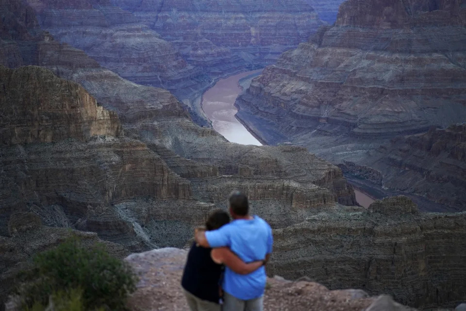
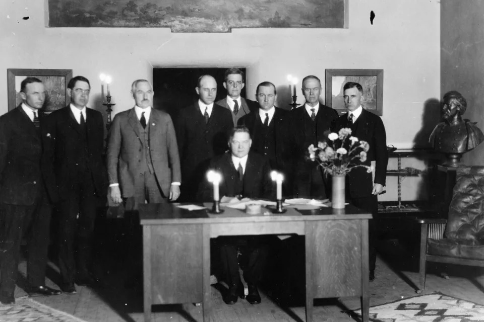
Alyssa Chubbuck, left, and Dan Bennett embrace while watching the sunset at Guano Point overlooking the Colorado River on the Hualapai reservation Monday, Aug. 15, 2022, in northwestern Arizona. In November 1922, seven land-owning white men brokered a deal to allocate water from the Colorado River, which winds through the West and ends in Mexico. During the past two decades, pressure has intensified on the river as the driest 22-year stretch in the past 1,200 years has gripped the southwestern U.S. (AP Photo/John Locher)FILE – A formerly sunken boat sits upright into the air with its stern stuck in the mud along the shoreline of Lake Mead at the Lake Mead National Recreation Area, June 10, 2022, near Boulder City, Nev. In November 1922, seven land-owning white men brokered a deal to allocate water from the Colorado River, which winds through the West and ends in Mexico. During the past two decades, pressure has intensified on the river as the driest 22-year stretch in the past 1,200 years has gripped the southwestern U.S. (AP Photo/John Locher, File)In this photo provided by the U.S. Bureau of Reclamation, Commerce Secretary Herbert Hoover presides over the signing of the Colorado River Compact in Santa Fe, N.M., on Nov. 24, 1922. Seven land-owning white men brokered a deal to allocate water from the Colorado River, which winds through the West and ends in Mexico. (U.S. Bureau of Reclamation via AP)Garnett Querta carries a hose as he fills his water truck on the Hualapai reservation Monday, Aug. 15, 2022, near Peach Springs, Ariz. The divvying up between Colorado River Basin states never took into account Indigenous Peoples or many others, and from the start the calculation of who should get what amount of that water may never have been balanced. (AP Photo/John Locher)A truck tire once in the water as part of a marina sits on dry ground as water levels have dropped near the Callville Bay Resort & Marina in the Lake Mead National Recreation Area, Tuesday, Aug. 30, 2022, near Boulder City, Nev. In November 1922, seven land-owning white men brokered a deal to allocate water from the Colorado River, which winds through the West and ends in Mexico. During the past two decades, pressure has intensified on the river as the driest 22-year stretch in the past 1,200 years has gripped the southwestern U.S. (AP Photo/John Locher)Floating boat docks sit on dry ground as water levels have dropped near the Callville Bay Resort & Marina in the Lake Mead National Recreation Area, Tuesday, Aug. 30, 2022, near Boulder City, Nev. As water levels plummet, calls for reduced use have often been met with increased population growth. (AP Photo/John Locher)Water flows along the All-American Canal Saturday, Aug. 13, 2022, near Winterhaven, Calif. In November 1922, seven land-owning white men brokered a deal to allocate water from the Colorado River, which winds through the West and ends in Mexico. During the past two decades, pressure has intensified on the river as the driest 22-year stretch in the past 1,200 years has gripped the southwestern U.S. (AP Photo/Gregory Bull)
DENVER (AP) — The intensifying crisis facing the Colorado River amounts to what is fundamentally a math problem.
The 40 million people who depend on the river to fill up a glass of water at the dinner table or wash their clothes or grow food across millions of acres use significantly more each year than actually flows through the banks of the Colorado.
In fact, first sliced up 100 years ago in a document known as the Colorado River Compact, the calculation of who gets what amount of that water may never have been balanced.
“The framers of the compact — and water leaders since then — have always either known or had access to the information that the allocations they were making were more than what the river could supply,” said Anne Castle, a senior fellow at the Getches-Wilkinson Center at the University of Colorado Law School.
EDITOR’S NOTE: This is part of a collaborative series on the Colorado River as the 100th anniversary of the historic Colorado River Compact approaches. The Associated Press, The Colorado Sun, The Albuquerque Journal, The Salt Lake Tribune, The Arizona Daily Star and The Nevada Independent are working together to explore the pressures on the river in 2022.
During the past two decades, however, the situation on the Colorado River has become significantly more unbalanced, more dire.
A drought scientists now believe is the driest 22-year stretch in the past 1,200 years has gripped the southwestern U.S., zapping flows in the river. What’s more, people continue to move to this part of the country. Arizona, Utah and Nevada all rank among the top 10 fastest growing states, according to U.S. Census data.
While Wyoming and New Mexico aren’t growing as quickly, residents watch as two key reservoirs — popular recreation destinations — are drawn down to prop up Lake Powell. Meanwhile, southern California’s Imperial Irrigation District uses more water than Arizona and Nevada combined, but stresses their essential role providing cattle feed and winter produce to the nation.
Until recently, water managers and politicians whose constituents rely on the river have avoided the most difficult questions about how to rebalance a system in which demand far outpaces supply. Instead, water managers have drained the country’s two largest reservoirs, Lake Mead and Lake Powell, faster than Mother Nature refills them.
In 2000, both reservoirs were about 95% full. Today, Mead and Powell are each about 27% full — once-healthy savings accounts now dangerously low.
The reservoirs are now so low that this summer Bureau of Reclamation Commissioner Camille Touton testified before the U.S. Senate Energy and Natural Resources Committee that between 2 million and 4 million acre-feet would need to be cut next year to prevent the system from reaching “critically low water levels,” threatening reservoir infrastructure and hydropower production.
The commissioner set an August deadline for the basin states to come up with options for potential water cuts. The Upper Basin states — Colorado, Utah, New Mexico and Wyoming — submitted a plan. The Lower Basin states — California, Arizona and Nevada — did not submit a combined plan.
The bureau threatened unilateral action in lieu of a basin-wide plan. When the 60-day deadline arrived, however, it did not announce any new water cuts. Instead, the bureau announced that predetermined water cuts for Arizona, Nevada and Mexico had kicked in and gave the states more time to come up with a basin-wide agreement.
STILL LEFT OUT
A week before Touton’s deadline, the representatives of 14 Native American tribes with water rights on the river sent the Bureau of Reclamation a letter expressing concern about being left out of the negotiating process.
“What is being discussed behind closed doors among the United States and the Basin States will likely have a direct impact on Basin Tribes’ water rights and other resources and we expect and demand that you protect our interests,” tribal representatives wrote.
Being left out of Colorado River talks is not a new problem for the tribes in the Colorado River Basin.
The initial compact was negotiated and signed on Nov. 24, 1922, by seven land-owning white men, who brokered the deal to benefit people who looked like them, said Jennifer Pitt of the National Audubon Society, who is working to restore rivers throughout the basin.
“They divided the water among themselves and their constituents without recognizing water needs for Mexico, the water needs of Native American tribes who were living in their midst and without recognizing the needs of the environment,” Pitt said.
Mexico, through which the tail of the Colorado meanders before trickling into the Pacific Ocean, secured its supply through a treaty in 1944. The treaty granted 1.5 million acre-feet on top of the original 15 million acre-feet that had already been divided, 7.5 million each for the Upper and Lower Basins.
Tribes, however, still don’t have full access to the Colorado River. Although the compact briefly noted that tribal rights predate all others, it lacked specificity, forcing individual tribes to negotiate settlements or file lawsuits to quantify those rights, many of which are still unresolved. It’s important to recognize the relationship between Native and non-Native people at that time, said Daryl Vigil, water administrator for the Jicarilla Apache Nation in New Mexico.
“In 1922, my tribe was subsistence living,” Vigil said. “The only way we could survive was through government rations on a piece of land that wasn’t our traditional homeland. That’s where we were at when the foundational law of the river was created.”
COMPETING INTERESTS
Agriculture uses the majority of the water on the river, around 70% or 80% depending on what organization is making the estimate. When it comes to the difficult question of how to reduce water use, farmers and ranchers are often looked to first.
Some pilot programs have focused on paying farmers to use less water, but unanswered questions remain about how to transfer the savings to Lake Powell for storage or how to create a program in a way that would not negatively impact a farmer’s water rights.
Antiquated state laws mean the amount of water that a water right gives someone access to can be decreased if not fully used.
That’s why the Camblin family ranch in Craig in northwest Colorado plans to flood irrigate once a decade, despite recently upgrading to an expensive, water-conserving pivot irrigation system. Nine years out of 10, they’ll receive payment from a conservation group in exchange for leaving the surplus water in the river. But in Colorado, the state revokes water rights after 10 years if they aren’t used.
Not only would losing that right mean they can’t access a backup water supply should their pivot system fail, but their property’s value would plummet, Mike Camblin explained. He runs a yearling cattle operation with his wife and daughter, and says an acre of land without water sells for $1,000, about a fifth of what it would sell for with a water right attached.
There are other ways to improve efficiency, but money is still often a barrier.
Wastewater recycling is growing across the region, albeit slowly, as it requires massive infrastructure overhauls. San Diego built a robust desalination plant to turn seawater to drinking water, and yet some agricultural users are trying to get out of their contract since the water is so expensive. Some cities are integrating natural wastewater filtration into their landscaping before the water flows back to the river. It’s all feasible, but is costly, and those costs often get passed directly to water users.
One of the biggest opportunities for water conservation is changing the way our landscapes look, said Lindsay Rogers, a water policy analyst at Western Resource Advocates, a nonprofit dedicated to protecting water and land in the West.
Converting a significant amount of outdoor landscaping to more drought-tolerant plants would require a combination of policies and incentives, Rogers explained. “Those are going to be really critical to closing our supply-demand gap.”
After years of incentive programs for residents, Las Vegas recently outlawed all nonfunctional grass by 2026, setting a blueprint for other Western communities. For years, the city has also paid residents to rip out their lawns.
In Denver, Denver Water supplies about 25% of the state’s population and uses about 2% of the water. The city has had mandatory restrictions in place for years, limiting home irrigation to three days per week.
This summer, in southern California, the Metropolitan Water District instituted an unprecedented one-day-a-week water restriction.
Still, regardless of the type of water use, more concessions must be made.
“The law of the river is not suited to what the river has become and what we see it increasingly becoming,” Audubon’s Pitt said. “It was built on the expectation of a larger water supply than we have.”
David Segal and José Bautista – September 10, 2022
A variety of olive oils at a shop in the town of Úbeda, in Spain’s olive oil producing province of Jaén, Aug. 26, 2022. (Emilio Parra Doiztua/The New York Times)
EL MOLAR, Spain — The branch, plucked from one of thousands of trees in a densely packed olive grove in this village, has browning leaves and a few tiny, desiccated buds that are bunched near the end. To Agustín Bautista, the branch tells a story, and the story is about a harvest that is doomed.
Typically, those buds are green and healthy, and can produce 13,000 gallons of olive oil in a season. That is more than enough for Bautista, a 42-year-old with a booming voice and close-cropped red hair, to support his wife and two young kids. Starting in October, when olives are shaken from the trees and gathered in nets on the ground, he’ll be lucky to produce one-fifth of that amount.
“I’m going to lose money,” he said, in the resigned tone of a man squarely in the acceptance stage of grief. As he looked around the arid acres of his property, he summed up the reality facing Spain’s olive farmers: “No water, no future.”
Drought has ravaged dozens of crops throughout Europe: corn in Romania, rice in Italy, beans in Belgium, and beets and garlic in France. Among the hardest hit is the olive crop of Spain, which produces half of the world’s olive oil. Nearly half of Spain’s output comes from Jaén, a landlocked southern province of 5,200 square miles, about the size of Connecticut, that yields far more olive oil annually than all of Italy, according to the International Olive Council. It is often called the olive oil capital of the world.
Farmers and political leaders are now searching for answers to a pressing question: What happens to a one-crop economy when that crop is scorched by record-breaking temperatures?
This has never been much of a tourist destination, but those who come, mostly to see Moorish fortresses and Renaissance-style cathedrals, are treated to a landscape unlike any other. Sixty-seven million olive trees are planted on every hill and valley, alongside every highway and road, in every direction. It has been called the largest man-made forest.
Since the Romans began planting this forest centuries ago, olive trees have sustained thousands of farmers and itinerant workers here. The trees thrive in a Mediterranean climate and need a minimal amount of rain. But not this minimal. Europe is suffering through its worst drought in 500 years, says the European Drought Observatory, a service run by the European Commission’s Joint Research Center, and is experiencing heat waves so severe that the nearby city of Seville gave one of them a name — Zoe — the way hurricanes and tropical storms are named in the United States.
The morning that Bautista studied the withered olive tree branch, he was sweating in heat that was already headed above 100 degrees by 11 a.m. As he drove his Toyota pickup truck around the 5,000 trees that he cultivates in a grove beside this tiny village where he grew up, he was already ruing lost profits. He and other farmers expect that the olive crop of Jaén will be about 50% smaller than last year. Government estimates of lost income now stand at $1 billion.
“The situation is critical,” said Francisco Reyes Martínez, president of the Provincial Council of Jaén. “A lot of people here are going to struggle.”
The harvest is just the latest setback for the hundreds of villages that dot Jaén and have relied for decades on the olive crop. El Molar has one bar, one church, no restaurants and an official population tally of 237.
“I think the actual number is closer to 200,” said the village mayor, Misericordia Jareño. “Some people have died.”
There were 1,000 people here when she moved to El Molar as a girl of 10, back in 1963. The place did not have a single paved road, and homes lacked running drinking water. But it had a high school, its own cuisine — she urged a visitor to return for dinner and try her gachamiga, a dish of olive oil, garlic, salt, water and wheat flour — and a sense of community that has endured even as the place slowly emptied.
Many remaining residents are fourth- or fifth-generation farmers who can trace their holdings back more than 100 years. They have an attachment to the business that transcends facts and figures, tiptoes into romance and bursts with civic pride. Oil from here winds up in dozens of varieties sold around the world, many of which can be purchased online directly from local mills.
The landscape has inspired some of Spain’s greatest poets (Miguel Hernández, Antonio Machado), singers (Juanito Valderrama) and painters (Rafael Zabaleta). Now the groves are turning up on social media. One Jaén farmer who has 1.7 million followers on TikTok makes gargantuan sandwiches, all generously slathered with olive oil.
With a nudge from the local government, a nascent olive oil tourism industry, dubbed oleoturismo, is starting to grow. There are spas with olive oil treatments and specialty shops, like Panaderia Paniaceite, that sell dozens of varieties of olive oil. One almazara, as traditional mills are known, offers olive oil tastings like wine tastings at a vineyard. Visitors can also spend a day working and living as an olive farmer, meals included, for 27 euros (about $27).
“It was a surprise to us, the amount of interest there is in seeing how we produce olive oil,” said José Jiménez, co-owner of the mill, Oleícola San Francisco, in a village called Baeza. “We’ve already had 50,000 visitors from 78 countries.”
Tourism will never offset losses in the fields nor thwart a variety of tectonic shifts that go far beyond the weather. A harvest that once took tens of thousands of people, including a massive influx of seasonal migrant workers, now requires a fraction of manpower because so much of the work is now done by machines. Most notably, there is the vibradora, a hand-held, gasoline-powered device — it looks like a chain saw with a very long, thin snout — that shakes olives out of trees by clamping onto branches and rattling them.
A person armed with a vibradora can shake 1,500 kilograms (about 3,300 pounds) of olives to the ground in a day. Using the traditional slap-it-with-a-stick technique, the number is closer to 200 kilograms a day.
That is one reason El Molar has been shedding population; far fewer people are needed for the harvest. And those still toiling in the groves face higher costs, especially now that inflation is over 9% in the eurozone, raising the price of electricity, fuel, fertilizer and labor.
“The cost of producing olive oil is now two or three times as expensive as it was 10 years ago,” said Juan Carlos Hervás, a farmer and expert with the local branch of a farmers union. He laid out the math: A liter of extra-virgin olive oil, the highest grade, now fetches 3.90 euros, well above the 1.8 euros per liter that was the going rate before the pandemic. But the price of harvesting that liter has gone up by 2.40 euros.
“We’re losing money now,” Hervás said. “For the first time in many years we’re seeing a good price for olive oil, but our costs are going up and it hasn’t rained in three months.”
Without expensive irrigation systems to water trees, many are fruitless. During Bautista’s drive through the groves of El Molar, there was a clear dichotomy: Trees that were quenched from a nearby reservoir, using many miles of black tubing, looked healthy and green. Those that were not were brown and barren.
“Eight liters per hour, for eight hours, one night a week,” said Bautista, explaining how much each tree is watered. That water is expensive, and farmers here need to buy a share of a reservoir cooperative, created in 2001, to access it. Many decided long ago to save their money, betting that rain would do the job for free.
That bet has never looked more catastrophic, although the portents were evident 15 years ago. José Felguera, the secretary of Asolite, a nonprofit association of olive tree farmers, said that in the mid-aughts, he and colleagues met with climatologists from Galicia, Spain, to pose a question: Why was there less and less rain?
“We saw lot more airplanes flying overhead, so we thought it had something to do with planes,” said Felguera, sitting near a public swimming pool in Arquillos, the village where he lives. “The climate scientists said that the planes had nothing to do with it.”
Felguera, who grew up in Arquillos, remembers two or three snowfalls a year as a child and creeks that were frozen so solid during winter that a rock couldn’t break the ice. Now, winters are dry and short, which he says is even more damaging to olive trees than torrid summers.
“These are trees made for dry weather, and periods of drought have been around forever,” he said. “But now the droughts are stronger and longer.”
Subsidies from the European Union have been essential to the olive farmers in Jaén for years. Currently, the rate is roughly 690 euros a year per hectare, said Juan Vilar Hernández, an agricultural analyst and professor at the University of Jaén. Given that the average farmer owns 1.58 hectares — about 4 acres — the average subsidy is roughly 1,090 euros a year.
“If you removed subsidies, about 80% of the farmers in Jaén would lose money,” he said. The subsidy is set to decrease in coming years, which alarms many farmers. One long-term solution is for farms here to embrace “modern oliviculture,” which means packing more trees into the same physical footprint, and then using additional industrial equipment during the harvest.
For much of Jaén, however, that isn’t possible. Most of its groves are on sloping hills where expensive new machines like olive harvesters — essentially, massive $500,000 tractors that drive over 14-foot trees — can’t operate. Inevitably, Jaén is going to lag in productivity compared with groves in California, Chile, Australia and elsewhere, Hernández said. The province may always be synonymous with olive production, but in the future it will be a competition that the province can’t win.
“The average age of an olive farmer here is 60,” he said. “And their children are all moving to cities. So in 20 years, no one is going to live in these villages.”
Luis Planas, Spain’s agriculture minister, said in an interview that the country needed to adapt to new conditions. He outlined a number of steps the government has already taken to provide short-term relief, including tax breaks and an increase in employment benefits. The goal is to save and sustain more than an industry.
“If villages like El Molar disappear, Spain will lose a very important part of its identity,” he said. “If the olive grove disappears, that area will become a desert.”
One recent Friday evening, El Molar ignored the weather and the laws of market economies arrayed against it and gathered for its annual summer fiesta. It had the feel of a family reunion, and included more than a few Bautistas, including a reporter of this story, who is Agustín’s cousin. Not much happened before about 11 p.m., when a brass band with a drummer noisily marched up the main street, playing a kid’s song, “Soy una Taza.” Beer and tortillas were sold at a pop-up restaurant and bar while children caromed around a bouncy castle set up nearby.
Many gathered under white tents set up in the village square. A few recent college graduates were on hand and rhapsodized about growing up here.
“My childhood was beautiful,” said Mario Romero, who was celebrating his 25th birthday. “When I was young, my parents taught me how to work in the olive trees and how to love this way of life.”
He liked being in nature, repairing broken equipment and having a sense of self-sufficiency. But he studied to be a teacher, and there is no longer a school for children older than 11 in the village. Like a lot of his friends, he won’t settle in El Molar because it lacks any opportunities aside from olive farming. That said, it will always be a part of his life. His parents still own 600 olive trees, and he has no intention of selling even one when he inherits them.
“I’d like to buy more,” he said. He imagines having children someday, and even if they never want to farm for a living, he wants to teach them how it is done. “The way my parents taught me.”
About midnight, a DJ showed up and started playing dance music at a tinnitus-inducing volume. As if on cue, the wind picked up, napkins started swirling in the air and to everyone’s collective delight, it started to rain, lightly at first.
An elderly woman named María la de Ricardo walked by, smiling.
“It is not normal to have rain in August,” she said. “But I was praying for it, and God listened.”
By then, it started to pour and everyone scurried for cover to watch the deluge.
‘Triple-dip’ La Niña is on the way. Here’s what it means for weather in the US
Doyle Rice, USA TODAY – September 9, 2022
La Niña just won’t go away.
Meteorologists say that for the third straight year, La Niña will persist throughout the winter in the Northern Hemisphere. This is the first “triple-dip” La Niña of the century, according to a recent update from the United Nations’ World Meteorological Organization.
This La Niña began in September 2020.
The La Niña climate pattern is a natural cycle marked by cooler-than-average ocean water in the central Pacific Ocean. It is one of the main drivers of weather in the United States and around the world, especially during late fall, winter and early spring.
It’s the opposite to the more well-known El Niño, which occurs when Pacific ocean water is warmer than average. While this would be the first “triple-dip” La Niña this century, it’s not unprecedented for the pattern to last more than nine months to a year, which is typical for a La Niña, according to ABC News.
A typical La Niña winter in the U.S. brings cold and snow to the Northwest and unusually dry conditions to most of the southern tier of the U.S., according to NOAA’s Climate Prediction Center. The Southeast and Mid-Atlantic also tend to see warmer-than-average temperatures during a La Niña winter.
Meanwhile, New England and the Upper Midwest into New York tend to see colder-than-average temperatures, the Weather Channel said.
Climate change also plays a role
However, the WMO said all naturally occurring climate events now take place in the context of human-induced climate change, which is increasing global temperatures, exacerbating extreme weather and climate, and impacting seasonal rainfall and temperature patterns.
“It is exceptional to have three consecutive years with a La Niña event,” said WMO Secretary-General Petteri Taalas in a news release. “Its cooling influence is temporarily slowing the rise in global temperatures – but it will not halt or reverse the long-term warming trend,” he added.
Where did the term La Niña come from?
Both La Niña and El Niño are Spanish language terms: La Niña means “little girl,” while El Niño means “little boy,” or “Christ child.” South American fishermen first noticed periods of unusually warm water in the Pacific Ocean in the 1600s, the National Oceanic and Atmospheric Administration said. The full name they used was “El Niño de Navidad” because El Niño typically peaks around December.
The entire natural climate cycle is officially known by climate scientists as El Niño – Southern Oscillation (ENSO), a see-saw dance of warmer and cooler seawater in the central Pacific Ocean.
During La Niña events, trade winds are even stronger than usual, pushing more warm water toward Asia, NOAA said. Off the west coast of the Americas, upwelling increases, bringing cold, nutrient-rich water to the surface.
Careers and climate change have Americans on the move: Here are the top 10 states people are leaving (and where they are going)
Serah Louis – September 8, 2022
Careers and climate change have Americans on the move: Here are the top 10 states people are leaving (and where they are going)
Americans are packing their bags (and ordering a moving truck) and leaving behind their home states — and flocking to new lodgings in other parts of the country.
Moving company United Van Lines released its 45th Annual National Movers Study in January, which provides data on the number of people who joined or left each state last year.
While work remains the No. 1 reason for leaving, with almost a third of movers exiting their state to pursue a new job opportunity or transfer — it’s a significant decrease from 2015, when over 60% of Americans cited work as their primary reason.
The United Van Lines study found that about 32% of movers were motivated to live closer to their families, a new migration trend that’s been influenced in part by the COVID-19 pandemic. Fast forward to this year, a Forbes study found that nearly a third of Americans surveyed cited climate change and worsening weather conditions as a reason to move in 2022.
Here are the states where Americans are packing up and leaving, followed by the ones they’re driving that moving van to.
10. Nebraska
Outbound moves: 55.7%
Nebraska made it to the top 10 for states Americans were fleeing last year — KMTV reports the Cornhusker State loses around 2,000 residents a year due to “brain drain.”
College-educated adults are moving out of Nebraska for better jobs and pay, and looking at larger cities with more to offer, according to David Drozd, research coordinator at UNO’s Center for Public Affairs.
Nearly 42% of movers pointed to work opportunities as their primary reason for departing the state.
Some people also find the weather a nuisance. “Our winters are very cold … What is worse than the cold itself is the wind. 20 degrees with a strong wind from the west can chill you to the bone. When it gets into the single digits with a strong wind, it is hard to deal with. I have had to jump start batteries in that kind of weather, and it is not fun,” writes Keith Rockefeller on Quora.
9. Ohio
@christiemitchell1104 / Twenty20
Outbound moves: 56.3%
Ohio didn’t change spots from last year’s ranking, remaining one of the states with the largest outflows.
A new job or job transfer is the number one reason for Ohio’s outbound moves, but 28% of Buckeye movers say it was retirement that prompted them to relocate elsewhere.
The state might boast a relatively low cost of living, but some say the erratic weather can be an issue.
“110 degrees in the summer with 90% humidity. Then a couple weeks of autumn weather. I missed the changing foliage. Then straight into frigid winter. We got what they called a polar vortex. It was -10 degrees for six weeks. I had seven feet of snow in my drive. Then a couple weeks of spring weather, and right back into the brutal summer,” recounts Quora user Curtis Williams, who says he used to reside in Elkhorn, Blair and Tekamah.
8. Louisiana
Outbound moves: 56.5%
Residents in the Pelican State are eager to escape the sweltering heat and low income opportunities.
An overwhelming majority of movers pointed to work as their primary reason for getting out of Louisiana — more than 30 percentage points higher than the second biggest motivator (family). And nearly half of movers were under the age of 45.
“Everyone I know has left. Low pay and not many opportunities especially if you aren’t aiming for oil field,” writes cain261 on Reddit.
7. Massachusetts
@eric_urquhart / Twenty20
Outbound moves: 57.6%
The Bay State might be renowned for its top educational institutions and charming coastal towns, but it’s also one of the least affordable states to live in the U.S.
The median home value lies upwards of $545,000, according to Zillow, and it’s even worse in cities like Boston.
Jobs, family and retirement were the top three reasons for movers abandoning Massachusetts.
“Gentrification is going on hardcore and causing rents to skyrocket even more. Kinda runs counter to the whole collegiate environment, as it’s hard for students to find affordable places to live,” writes Thomas Griffin on Quora.
6. Michigan
Outbound moves: 57.7%
Michigan is widely considered the center of the American automotive industry, but more residents are packing their bags and driving out of the state than into it.
Although the desire to be closer to family was the primary motivation for almost half the inbound movers, a third of outbound movers said they exited the Great Lake State for jobs.
Michigan also has one of the highest average auto insurance rates in the nation and residents say driving in the colder months can get particularly treacherous.
“The weather is miserable six months of the year. If you’re into winter sports, roads so icy that you fear for your life every time you get behind the wheel every winter, and constant grey dreary skies, then Michigan winters might be fine for you,” says one anonymous Quora user.
5. California
@TonyTheTigersSon / Twenty20
Outbound moves: 59.3%
California’s home to Disneyland, Hollywood and Silicon Valley — what’s not to love? — but the Golden State can lack luster for those who can’t afford it.
California’s quite expensive to live in, with the highest gasoline taxes in the nation, according to the American Petroleum Institute.
About 35% of movers also said they left the state to be closer to their family.
Quora user and resident Andrew T. Post claims overpopulation is a major problem in the state. “Housing prices are sky high. There’s too little housing and too many people — and too many regulations on the building of new housing. Traffic is insane, even in non-major cities.”
4. Connecticut
Outbound moves: 60.1%
The Nutmeg State is burdened by high taxes and expensive housing, and its residents simply cannot afford to stay.
About a third of outbound movers cite retirement as their primary motivation for leaving the state. Unlike most other states, all of your retirement income — including Social Security — gets taxed in Connecticut.
Residents contend with high property taxes as well. Others take issue with the weather.
“Winters are long, cold and usually quite snowy. Night time starts at 4:00 or so in the afternoon in the depths of winter. Go to work with your headlights on, and come home with them on again,” says resident David Dill on Quora.
3. New York
@itgnet / Twenty20
Outbound moves: 63.1%
The Empire State underwent an exodus during the COVID-19 pandemic with residents fleeing cramped, overcrowded apartments for more open, greener spaces.
New York slid down by one spot in 2021, however it still made the top three for outbound moves.
The top reason for movers exiting New York last year was to be closer to one’s family (29.4%), closely followed by retirement (29%).
“Most of New York State’s population can be found in the New York City area and, frankly, there’s no more room … The other population centers in New York are suffering from a combination of urban sprawl and a hollow industrial base. Buffalo, for example, has been losing population since 1950 and the growth of the metro area hasn’t kept pace,” says Steven Haddock on Quora.
2. Illinois
Outbound moves: 67.2%
Unlike New York, the Prairie State has plenty of rolling hills and open plains — and yet Americans are still fleeing Illinois in droves.
About 3 in 10 outbound movers left Illinois to be closer to their family. Around 28% each cited either retirement or jobs.
The state lacks job opportunities and reached an all-time high for resignations in August last year during the Great Resignation. To make matters worse, Kiplinger named it the least tax-friendly state for middle-class families in 2021.
Others say the climate can be off-putting as well. “I just can’t deal with winter or the humidity very well anymore. It used to only be the winter, but as I get older the humidity affects me more and more. We have 11 years until retirement and then we are moving to a cheaper, more temperate area,” says Sloth_grl on Reddit.
1. New Jersey
@p__nutbutter83 / Twenty20
Outbound moves: 70.5%
The Garden State holds the dubious distinction of holding the highest percentage of outbound moves — for the fourth year in a row.
About a third of movers said retirement was their main reason for relocating elsewhere.
New Jersey has some of the highest property taxes in the nation and the median home value is around $430,000, according to Zillow.
“It’s overpopulated, over-regulated and overtaxed. People also tend to hate it because almost every approach to the state drops you right in the middle of an industrial wasteland, and if you drive through it you only see the massively crowded highways,” writes emperorko on Reddit.
So those are the states people are fleeing the fastest. But where are all those people moving to?
The National Movers Study also contains data on the states Americans are flocking to as they seek better prospects and a more comfortable life for their families.
Keep reading as we check out the top states people are moving to.
10 (tie). District of Columbia
@motherspreciousgems / Twenty20
Inbound moves: 59.1%
Washington, D.C. might not technically be a state — but United Van Lines still includes it on its list every year.
D.C. moved up five spots from the previous year’s ranking, and while it’s considered pretty pricey to live in, the job market’s thriving and you can expect higher-than-average income as well, according to the U.S. Census Bureau.
Redditor Gumburcules says D.C. also trumps other big cities you might normally compare it to.
“It’s so much quieter and more relaxed than NY. It’s much more compact and convenient than LA. The weather is miles better than Chicago, and you’re not stuck in the middle of the country, which makes travel and weekend getaways a million times better.”
10 (tie). Rhode Island
Inbound moves: 59.1%
America’s tiniest state has been steadily moving up the ranks of United Van Lines’ national movers list in recent years, jumping into the top 10 for inbound moves in 2021.
Nearly 36% of those entering Rhode Island said the jobs convinced them to relocate to the state.
That said, it’s also one of the costliest states to live in the U.S. and half of all inbound movers reported an income of $150,000 or more.
“It’s basically the Shire in LOTR, everyone knows everyone, people are generally friendly with each other but distrusting of strangers, and generally the people that live here never leave or want to leave,” says Redditor draqsko.
9. Idaho
@codykliu / Twenty20
Inbound moves: 60.4%
The Gem State wasn’t quite as prized in 2021 as it has been in previous years, plunging from first to ninth place.
Contrary to popular belief, Idaho isn’t all farmland and potatoes — its IT job market in particular has been flourishing and the state’s Department of Labor also reported strong population and job growth last year.
The low cost of living and abundance of outdoor recreational opportunities can make Idaho attractive to Americans seeking a more affordable lifestyle and open spaces as well.
“There’s a lot of positives especially if you’re the outdoors type. Huge swaths of wilderness in the state, desert in the south with more mountainous terrain and forests in the central and northern parts of the state. Even in Boise (where traffic can get ‘bad’), an hour of driving will get you into the wilderness,” says stormy370 on Reddit.
8. Oregon
Inbound moves: 60.5%
Lush forests and blue rivers delineate the Beaver State — however, its natural beauty wasn’t enough to stop it from slipping down the list.
Oregon took third place in United Van Lines’ list for 2021 and before that it held at No. 2 for three years in a row.
A sizable chunk of inbound movers (44%) said they chose Oregon for work-related reasons and that’s unsurprising considering the state’s thriving tech industry. A number of high-tech businesses are clustered around the Silicon Forest area around Portland.
That said, the state’s high cost of living and ballooning homeless population have become an issue for many.
7. Tennessee
@jazzze_phe / Twenty20
Inbound moves: 62%
Tennessee is home to more than just Graceland and fried chicken — plenty of Americans love the state for its low cost of living and affordable homes.
The Volunteer State has fairly low property taxes and won’t tax your Social Security benefits or income. Just be prepared to deal with sky-high sales taxes when you do your shopping.
The climate can be hit-or-miss for some people, as Larry Gwinn writes on Quora.
“If you hate winter, then Tennessee is a great state for you. Tennessee’s winter is mild and short. But, its summer is long and very humid.”
6. Alabama
Inbound moves: 62.1%
Sweet Home Alabama certainly lives up to much of the hype, ranking sixth place on United Van Lines’ list.
Residents in the Yellowhammer State benefit from extremely low property taxes and cheap home values.
However, Alabama’s job market was the top reason for both people moving out and into the state. The unemployment rate is fairly low, but median household income in the state is lower than the national median.
“Travel is easy and cheap in one of the most ecologically diverse states, meaning there is a ton to see and do in nature without spending much. Lots of diverse small/medium cities to visit … Alabama is also a sick hub for great weekend trips. Nashville, New Orleans, Atlanta are all reasonable to go to on a Friday after work and enjoy the weekend in,” says jsm2008 on Reddit.
5. Florida
@Hanni / Twenty20
Inbound moves: 62.3%
Florida’s got a little bit of everything for everyone, whether you’re hitting up the local beaches and theme parks or just looking for the ideal spot to settle down in your golden years.
Retirees adore the state (retirement was the top reason for almost 39% of inbound movers) for its excellent climate and recreational opportunities, as well as its tax-friendliness. There’s no state income tax, and the sales and property taxes are pretty average compared to the rest of the country.
It’s not all sunshine and rainbows in the Sunshine State, however, according to AdrianArmbruster on Reddit.
“It’s definitely not going to be all vaporwave aesthetics and Miami Beach sunsets all the time. Definitely don’t go expecting that. The primary industry being tourism both raises prices and depresses wages. Anyone thinking of coming here with a penny to their name may want to keep that in mind.”
3 (tie). West Virginia
Inbound moves: 63%
Those country roads are taking plenty of Americans into West Virginia — the state jumped up eight spots to make it to third place for inbound moves in 2021.
Close to half of those entering the Mountain State cited jobs as their main motivator, but a whopping 72% said they exited the state for the same reason.
West Virginia grapples with one of the worst poverty rates in the country, particularly with the decline of its coal industry.
However, Redditor OMothmanWhereArtThou says, “The cost of living in West Virginia is really low and it has so much natural beauty. If you’re an outdoorsy person, you can find a lot to get into. If you’re a fan of living near very few people, that can be easily achieved in WV.”
3 (tie). South Carolina
@speakboston / Twenty20
Inbound moves: 63.3%
South Carolina boasts a warm climate, friendly residents and outdoor attractions like Myrtle Beach and the salt marshes.
Like in 2020, the top reason for moving to the Palmetto State was retirement, and almost 70% of the new residents last year were 55 or older.
South Carolina is well known for its golf courses, beaches and historic buildings — and it’s pretty tax-friendly for retirees as well.
“There are plenty of gorgeous towns around: Beaufort, Hilton Head, Myrtle Beach and Charleston. I would even say that Charleston is perhaps the most underrated city in the U.S. I don’t think you can find that sort of wonderful, unique and well-preserved southern British colonial architecture anywhere else in the U.S.,” writes TheWalkingKing on Reddit.
2. South Dakota
Inbound moves: 68.8%
The Mount Rushmore State is clearly more than just the massive granite carvings it gets its nickname from — drawing almost 70% of its movers last year.
In fact, the desire to be closer to family was the main motivator for those relocating to South Dakota.
The cost of living is lower-than-average, plus the state has no income tax and low sales taxes.
“Sioux Falls is consistently rated one of the best places in the U.S. to live. It’s got a gorgeous parks system and lively local music scene. As to the rural parts of the state, it’s incredibly beautiful, basically the lyrics to ‘America the Beautiful’: beautiful, spacious skies; amber waves of grain; purple mountains majestically rising above a fruited plain,” writes nemo_sum on Reddit.
1. Vermont
@eric_urquhart / Twenty20
Inbound moves: 74.3%
Despite being one of the least populated states in the nation, Vermont ranks No. 1 for the highest percentage of inbound moves in 2021.
Over 43% of inbound movers cited the jobs as their main reason for moving. The state has one of the lowest unemployment rates in the U.S., however it’s also considered quite expensive to run a business there, so it’s not ideal for launching a startup.
Redditor luxorange recommends the Green Mountain State for its natural beauty and recreational opportunities.
“It’s a really outdoorsy state. People are all about being outside, hiking, kayaking, biking, skiing. No matter where you live here, it is beautiful. The seasons are fun, it’s almost always a pretty drive, and the air is clean (seriously underrated feature of VT, how good the air smells).”
Rising seas fueled by climate change to swamp $34B in US real estate in just 30 years, analysis finds
Dinah Voyles Pulver, USA TODAY – September 8, 2022
Higher high tides, supercharged by rising sea levels, could flood all or parts of an estimated $34 billion worth of real estate along the nation’s coasts within just 30 years, a new report concludes.
Within the span of a 30-year mortgage, as many as 64,000 buildings and roughly 637,000 properties along the ocean and its connecting waterways could be at least partially below the tidal boundary level, the nonprofit Climate Central stated in a report released Thursday morning.
Seas are forecast to rise from 8 inches to 23 inches along the nation’s coasts by 2050, with the higher increases along the northern Gulf Coast and mid-Atlantic. As the oceans rise, every inch of additional water is expected to move farther inland making flood events worse and putting more properties at risk.
Tax dollars flowing into local governments will sink as rising water claims homes and land, lowering property values and sending a ripple effect through communities, said Don Bain, an engineer and Climate Central senior adviser.
The analysis concluded such losses could triple by 2100 in counties connected to the sea, depending on whether the world can rein in warming temperatures
The nonprofit looked at tax assessment data for 328 counties throughout the U.S. and tidal level property boundaries and elevation. Here’s what its analysis found:
Underwater
More than 48,000 properties could be entirely below the high tide lines by 2050, mostly in Louisiana, Florida and Texas.
Nearly 300,000 buildings could be at least partially under water by 2100. The value of buildings and properties below the high water level could rise to $108 billion, not including some 90 counties where the nonprofit couldn’t get tax assessor data.
Parishes under pressure
Parishes in low-lying Louisiana – where sinking ground compounds the effects of rising sea levels – are forecast to feel the brunt of the impacts. The analysis shows some 8.7% of the state’s total land area could be below water level by 2050.
Thirteen parishes rank in the top 20 among all counties and parishes for the most acres potentially below water level by 2050. More than half of the land in six parishes could be below water level by then, including Terrebonne, LaFourche, St. Charles, St. Mary, St. Bernard and St. John the Baptist.
A scattering of counties in five other states also could feel bigger impacts.
New Jersey’s Hudson County, across the Hudson River from Manhattan, is among those, with more than 15% of its total acreage below the predicted higher water levels. It leads all counties in the nation with an estimated value of land and buildings at risk: more than $2.4 billion.
Also among the top 20 counties with the most acres predicted below water level by 2050 are:
Middlesex, along the Chesapeake Bay in Virginia
Monroe, home of the Florida Keys
Jefferson, Texas, on the northern Gulf coast at Beaumont
Dare, Tyrell and Currituck counties along North Carolina’s Outer Banks and Albemarle Sound
Among the counties with the greatest property values at stake are:
Galveston, Texas, $2.37 billion
Honolulu, Hawaii, $2.3 billion
Washington, DC, $1.4 billion
Miami-Dade, Florida, $1.3 billion
Losing land
As much as 4.4 million acres could fall below the shoreline boundaries that mark the line between private property and public land by 2050, a number the report estimated would double by 2100. The majority of that land in 2050 – 3.8 million acres – lies in just four states: Louisiana, Florida, North Carolina and Texas.
“Your land is going to be taken from you by the rising seas,” Bain said. “Nobody’s talking about that.”
The analysis used the relevant tidal boundary for each state, whether it’s the mean low water line, the mean high water line or the mean higher high water line, then calculated the land within each property that could fall below that boundary as seas rise.
They calculated the exposed tax-assessed value for properties that could be newly affected by higher water and multiplied the value of each property by the fraction forecast to be below the line. They used an entire building’s value when any of the building is at or below the line.
The loss of taxable value could greatly impact the budgets of many towns and counties, said A.R. Siders, an assistant professor in the University of Delaware’s Disaster Research Center. “If a town has no other income and is relying solely on property tax values, that town is not sustainable.”
Risky business
Climate Central is among numerous groups working to better define the nation’s climate risk.
The need for such information is huge as mortgage lenders, insurers and others try to discern what the future holds and what it means for business, said Bain, adding it’s important to balance sheets for governments, individuals and corporations.
“Climate change impacts are real,” said Mark Rupp with the Georgetown Climate Center at Georgetown University. “They are happening now, and they are affecting even the business world.
“How many mortgage lenders want to be lending for home mortgages in flood-prone areas, if they don’t think that they’re going to get paid back?”
Rupp also pointed to the number of insurance carriers who have pulled out of the market in Florida or become insolvent. He said it’s critical for local governments to get support from state and federal governments to plan and prepare in advance.
Inspire not frighten
The report’s conclusions aren’t meant to frighten or discourage people, Bain said. He hopes they give people information to influence outcomes and push officials at every level of government to begin working together now to adopt needed laws and regulations.
“I’s not too late to make course corrections,” Bain said. “Solving this problem is important because it’s a choice between better outcomes and really bad outcomes.”
It’s important to educate and inform people about what they’re facing so they can do the rest, Bain said. “I think we can have a bright and prosperous future but only if we put our minds and shoulders to it, and are well-informed and get after it.”
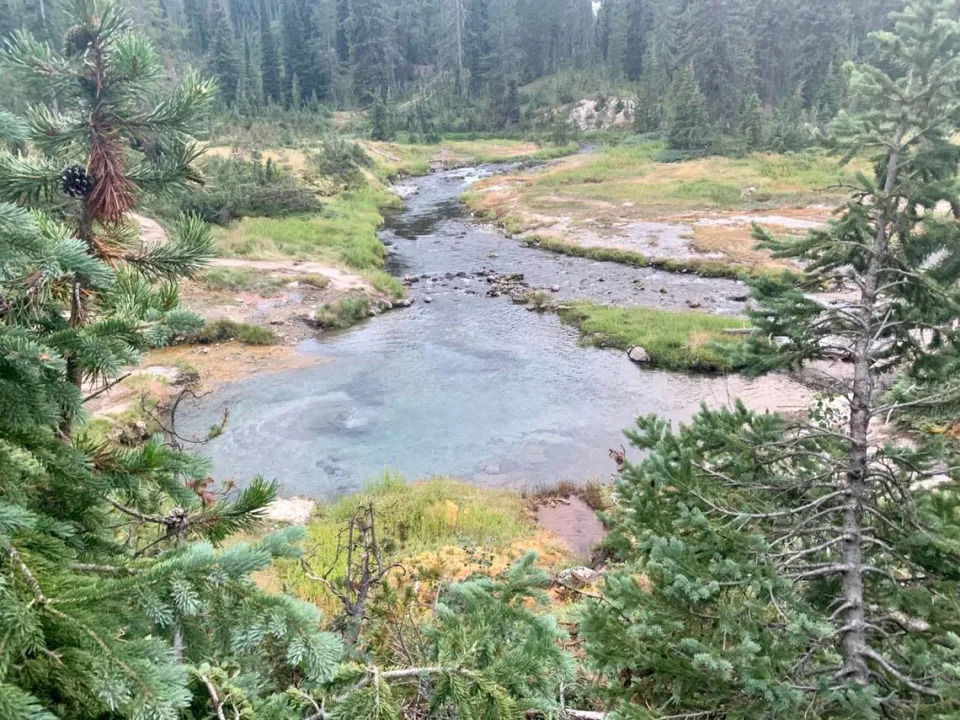
Into the zone of death: 4 days spent deep in Idaho’s remote Yellowstone backcountry
Clark Corbin – September 7, 2022
The ranger warned us before we attempted to enter the “zone of death.”
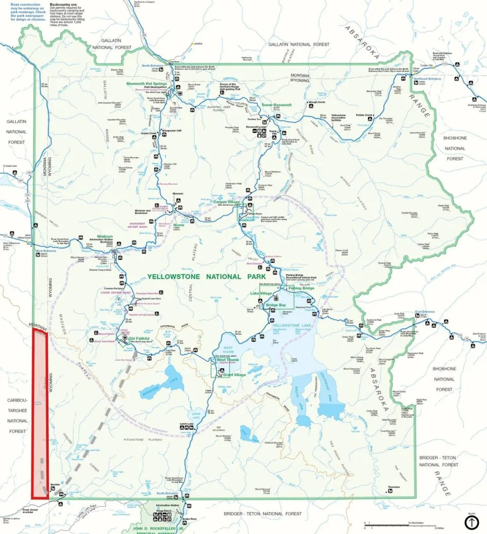
Millions of people visit Yellowstone National Park each year, but one of the least visited parts of the park, the so-called zone of death, lies in Idaho.
It’s rugged and remote, with no roads, a place where the trail grows faint and grizzly bears or cascading waterfalls could be just around the corner. Nobody lives there, and almost nobody camps there overnight. There are even rumors that you can get away with murder there.
Most of Yellowstone is located in Wyoming, but small portions extend into Montana and Idaho.
The narrow slice of Yellowstone in Idaho is situated in the roadless southwest corner of the park. It sees few human visitors because of how far it is from the main park roads and because it is overshadowed by the more popular, Instagram-friendly waterfalls, rivers and geothermal features located relatively close by in the Wyoming section of Yellowstone.
It is truly one of the last wild places in the American West.
“Other than a few changes, improvements in trails and some of the backcountry cabins, most of which were built in late teens and early ‘20s, most of the backcountry is just the same way people would have seen the park 150 years ago when the park was established,” Yellowstone backcountry ranger Michael Curtis told the Idaho Capital Sun. “That is what is pretty unique. You can go and get a sense of what people saw 150 years ago and experience it and know that it is largely unchanged.”
Another ranger warned us that the Idaho section of Yellowstone we planned to access off the Robinson Creek Trail saw so little traffic that the trail grew faint and overgrown and could be hard to follow. Rangers even had a hard time finding the Robinson Creek backcountry campsite when they traveled that way to clear trails and inspect backcountry sites earlier in the spring.
It sounded perfect.
So earlier this month, I set out with Boise journalist Heath Druzin, host of the Extremely American Podcast, to leave the crowds behind and backpack deep into Yellowstone’s backcountry. We hoped to see a side of Yellowstone that few tourists see, and we planned to finish our trip with one night in the Idaho section of Yellowstone.
We took the hard way, backpacking a total of 52 miles in just under 72 hours.
Idaho Capital Sun reporter Clark Corbin navigates a crossing of the Bechler River in Yellowstone National Park.
Day 1, Wyoming: A gushing geyser and a long slog over the Continental Divide
There were a lot of logistics that went into planning our hike, which we staged as a sort of thru-hike rather than an out-and-back or looped trip. We mapped out our route and applied for the required backcountry permit and campsites months in advance. We practiced Leave No trace principles, including packing in and packing out everything we needed and used, especially our trash. We stashed one vehicle at our finish line, the Bechler Ranger Station near the Wyoming-Idaho border, the night before we started backpacking.
We drove the other vehicle into the West Entrance of Yellowstone National Park at West Yellowstone, Montana, early on our first morning. We stopped at Old Faithful but quickly jumped back in the car when we learned it wasn’t predicted to erupt for more than an hour. A couple miles later, we left our remaining vehicle at the Lone Star Trailhead, shouldered our 35- to 40-pound packs, holstered our bear spray and began walking south, saying goodbye to roads and motorized vehicles.
We followed the Firehole River for the first couple of miles, swatting away the first of thousands of mosquitoes that would feast upon us for the remainder of the trip.
After 45 minutes, we reached the Lone Star Geyser and encountered a small crowd of about 20 hikers waiting with anticipation.
The Lone Star Geyser is a 12-foot cone that erupts about once every three hours, according to Yellowstone National Park. By comparison, Old Faithful erupts about every 75 to 90 minutes.
Lone Star is just far enough from the road and takes just long between eruptions that it doesn’t draw near the crowds of Old Faithful, which regularly attracts hundreds of people to its viewing platform.
Our trip was already starting strong.
“You’re just in time,” a child yelled out as Druzin and I approached and Lone Star Geyser began churning and splashing, belching a melange of steam, sulfur and hot water from its geothermal cone.
Within 15 minutes of our arrival, Lone Star was in full eruption, blasting scalding hot water more than 45 feet into the air.
After photos and a snack, it was time to hit the trail and begin climbing toward the Continental Divide. The Continental Divide stretches from Alaska down through Mexico and beyond, a crest following high mountain ranges that separates the waters that flow to the Pacific Ocean from the waters that flow to the Gulf of Mexico. The Continental Divide frequently crosses trails and roads through Yellowstone National Park and can be thought of as an invisible line, where raindrops falling on one side will eventually flow to the Pacific Ocean and raindrops falling on the other side will eventually flow to the Gulf of Mexico, as Annie Carlson, a research coordinator for the Yellowstone Center for Resources previously wrote in the Sun.
We hiked uphill through the hottest part of the day on one of the hottest days of the summer, moving slowly under heavy packs, seemingly inching forward up to an elevation of about 8,600 feet before the trail leveled off and then quickly turned downhill.
By the time I reached our destination and first backcountry campsite, Gregg Fork, I was exhausted and my shoulders burned with a searing pain.
Neither of us ate a full dinner, but just before dark we slung our heaviest pack high up a tree to lighten our loads and set out on another exploratory hike. The extra mission brought our total mileage for the day to 20 miles, but it also led us to confirm the location of one of the true highlights of the trip, a backcountry hot spring nestled deep in a geothermal zone.
An influx of cold water from the connecting creek make it possible to enjoy a soak in Mr. Bubbles hot spring, which is located in Yellowstone National Park’s backcountry.
Day 2, Wyoming: A magical backcountry hot spring, big river crossings and an unrelenting thunderstorm
Even though the secret is out, there is no sign pointing the way to Mr. Bubbles hot springs, our first destination on our second day in Yellowstone’s backcountry.
At one point along the Bechler River Trail, there is a fork offering three different directions hikers can travel. A sign points to destinations in two different directions. Take the third option, an unsigned spur trail that looks like a spot to rest horses. Follow it for about half a mile and the steam from a geyser basin soon appears. Continue to follow the trail, stepping carefully over and across shallow pools and creeks of geothermal water until reaching Mr. Bubbles, a large swimming pool-sized hot spring where cold waters from a nearby creek mix with a bubbling geothermal feature that gives the hot spring its namesake.
Yellowstone prohibits bathing, soaking or swimming in water entirely of thermal origin, but the cold waters of the creek mixing with the hot geothermal water make it safe and legal to soak in Mr. Bubbles.
Our second day on the trail started off cloudy with much cooler temperatures and the threat of rain. We had fewer miles to cover, so we soaked lazily for about 90 minutes in Mr. Bubbles’ warm waters. As we waded waist-deep nearly up to the bubbling water at the center of the pool, we felt the ground at the bottom of the pool subtly rock and shift, almost as if a small earthquake was concentrated right under the hot spring.
As we soaked, steam rose from the much hotter nearby geothermal features and their orange prismatic pools. We felt as though we’d left civilization behind for the warm waters of an alien planet.
As tempting and relaxing as Mr. Bubbles was after a long first day in the backcountry, we knew we had to get moving. Our day’s agenda called for covering another 15 miles along The Bechler River Trail, a journey that we knew would include at least three river crossings.
We ended up getting a bonus river crossing.
The trail crosses rivers and creeks several times, but many of the crossings feature bridges, strategically placed logs that span the gaps or large stones arranged to enable a hiker to hop across and stay dry. Sometimes, there was no bridge, log or stone path, and we had to ford the river, wading across at what we hope is a relatively shallow spot.
The first crossing allowed us to ease into it. A footbridge over a modest creek had washed out. We took our boots off and slipped on river sandals and water shoes, respectively, unbuckled the straps on our packs for safety and waded gingerly across the 40-foot creek. It was barely knee-deep and not as cold as we were warned to expect following spring snowmelt and runoff.
We felt alive and rejuvenated as we crossed.
Our confidence continued to increase just as the weather turned bad and the river crossing became bigger and burlier. We navigated two more crossings of the Bechler River, crossing 60-foot sections of river where the water reached the top of our thighs.
Descending through the Bechler Canyon, thunderclaps began to boom and lighting flickered overhead as a cool rain started to fall. The canyon section of our hike was full of lush, leafy vegetation that absorbed all the rainwater and soaked us thoroughly as we hiked. We trudged through the unrelenting thunderstorm for almost four hours, quickly passing by scenic landmarks such as the 45-foot Iris Falls. With about five miles still to travel and lightning overhead, we lingered just long enough to snap a few photos of the waterfall and complain about how quickly our Gore-Tex boots became soaked and squishy.
Every hour we consulted our map, and every hour it seemed like we still had another three or four miles to go.
Finally, I smelled smoke and we came across a group of horses tied to a hitching post below some trees, just off the trail. Just around the corner we came across a camp of cowboys who were beginning a multi-day guided horseback trip through the Bechler Meadows.
“Lovely weather we’re having,” I called out in the most cheerful voice I could muster up.
“Care to join us and warm up for a bit?” one of the cowboys responded.
They had a huge, crackling fire roaring in their camp.
“Thanks! We’ll be right up,” Druzin said.
Standing beside the fire our pants and boots began to dry out and our spirits were buoyed. One of the men on the horseback trip identified himself as a Ukrainian minister, and told us of his unwavering belief in the goodness of people. When Russian forces invaded Ukraine in February, members of Russian churches immediately stepped up and donated hundreds of thousands of dollars to help Ukrainian people, the man said. No matter how bad things get, he told us, continue to have faith in people’s capacity to do good.
Sufficiently warm and full of a new optimism for life, we thanked our cowboy hosts, wished them luck on their adventure in Yellowstone and jumped back on the trail to finish the remainder of our day’s hike in the rain.
Our optimism continued unabated for about half an hour until we encountered the remaining members of the cowboy posse at our final river crossing of the day.
Starting out from the opposite river bank that we were standing on, two cowboys leading a team of pack animals crossed the river on horseback. Initially, the crossing looked smooth and easy, with the water never rising above the horses’ knees. But as they neared our side of the bank, the water became much deeper, rising above the horses’ knees and touching their bellies.
As soon as the first cowboy reached dry land, we exchanged greetings and he began to complain about being wet and cold.
“Not as wet as we’re about to be,” Druzin said, motioning to the river.
“You’re crossing here?” the cowboy said in disbelief.
All we could do was nod and say that our campsite was on the other side of the river. The cowboys left us behind, with the first cold, wet cowboy saying he would keep his ears open for any high-pitched screaming coming from this direction.
Great.
We were intimidated by the depth of the water and spent 20 minutes looking for a shallower spot to wade across. Druzin initially set out cautiously on a precarious log that was balanced a little too delicately over deeper, fast moving water. Druzin noticed the danger in time and backed slowly off the log.
With darkness about to settle in and our campsite, Lower Boundary Creek, situated on the far side of the river, we regrouped and headed back to the spot where the cold cowboys and their horses had just crossed. We hoisted our packs entirely over our head in an effort to keep our packs, tents, sleeping bags and remaining clothing dry and waded into the water. The water reached the top of our thighs and soaked our behinds, but it was calm and the riverbed wasn’t too slippery. Before we knew it, we had safely walked across.
It took a total of 16 miles to reach camp on our second day, and the mosquitoes set upon us immediately. I was cold and wet and knew my clothes and boots wouldn’t dry until the sun came out the next day. My sleeping pad was soaked and unusable for the night. My frustration and self pity didn’t subside until my second healthy pull off the whiskey in camp.
I perked up just before crawling into my tent, knowing that next day’s adventure would lead us into the zone of death.
What is the zone of death?
The zone of death (highlighted in red) is defined by the intersection of Yellowstone National Park (highlighted in green) with the state of Idaho, in the southwest corner of the park. The grey dotted line represents the approximate path followed for this article, starting south of Old Faithful, traveling toward the southwest. The trip covered 52 miles.
Michigan State University’s College of Law professor Brian C. Kalt wrote a 2005 research paper published in the Georgetown Law Journal called “The Perfect Crime,” which suggested Yellowstone’s zone of death might be a place “where one might commit felonies with impunity.” The idea behind the theory is that nobody lives in the roughly 50-mile section of Yellowstone that lies in Idaho. Therefore, prosecution for certain federal felonies could become tricky if a defendant evoked their Sixth Amendment right to be tried by a jury from the state and district where the crime occurred.
The Idaho Legislature even debated the issue and adopted House Joint Memorial 3, which calls on Congress to close the zone of death “loophole,” during the 2022 legislative session.
State Rep. Colin Nash, the Boise Democrat who sponsored House Joint Memorial 3, told the Sun last month that he has not heard any feedback or received a response from Idaho’s congressional delegation on the matter.
For their part, Yellowstone officials aren’t worried that there is a loophole to close.
“We don’t talk in theoretical terms,” Yellowstone spokeswoman Linda Veress told the Sun. “If a crime occurs there, we will treat it like a crime occurred anywhere else in the park.”
Veress and Curtis, the backcountry district ranger, said the United States government has exclusive jurisdiction in Yellowstone and the states don’t even get involved. Yellowstone has its own law enforcement rangers, and there is also an investigative services branch within the National Park Service that focuses on more complex crimes, Curtis said.
“All crimes that are either detected when we are out on patrol or get reported, we investigate through the law enforcement rangers assigned to the park,” Curtis said. “If they are felony-level cases, a lot of times those are investigated with the National Park Service.”
Once a potential crime is investigated, law enforcement rangers or agents with the investigative services branch of the National Park Service work with an assistant U.S. attorney. Curtis and Veress said they aren’t aware of any issues or concerns with the current practices.
Day 3, Idaho: Into the zone of death
After tearing down camp at Lower Boundary Creek and wiggling into my still-damp clothing and boots, we hit the Bechler Meadows Trail. We made a quick stop at the Bechler Ranger Station to switch reservations to the Little Robinson Creek backcountry site in the zone of death, hoping it would be easier to find than our original site the rangers warned us could be tricky to locate.
With the new permit in hand, we headed up Robinson Creek Trail, which also appears to be identified as the West Boundary Trail on some maps and trail signs.
It was immediately obvious we were stepping off the beaten path. Whereas the trail in the Bechler River and Bechler Meadows sections of Wyoming was clearly defined, cleared of debris and trodden with fresh footsteps, the Robinson Creek Trail was overgrown and lush. We had to engage in some bushwhacking and a series of little guessing games to continue to follow the trail.
If we didn’t have electronic and paper maps, the ranger’s warning and know for sure we were heading the right way, we would have turned around thinking we were about to get hopelessly lost or surprise some big animal.
“It was more of a suggestion than a trail,” Druzin said.
Few people visit the Idaho section of Yellowstone National Park.
There is no “welcome to Idaho” sign in this section of Yellowstone marking the entrance to the zone of death. Instead, we relied on GPS to figure out the boundary, deciding it was just before a large boulder situated just off the trail in a thick tangle of brush and vegetation.
We passed a huckleberry bush and ate handfuls of plump, purple huckleberries. At about that same spot, we encountered our first pile of soft, fresh bear scat.
We continued on, passing meadows the size of NFL stadiums and giant marshes covered in lily pads.
“It’s amazing,” Veress said. “People say the park is so crowded, but you don’t have to go far from the road to have solitude.”
We reached our campsite, Little Robinson Creek, by early afternoon on our third day in the Yellowstone backcountry. To avoid conflicts with bears and other wild critters, we hung all of our packs, trash and food high above the ground on trees and logs that had been specially arranged for storage at backcountry campsites.
The first thing we saw at Little Robinson Creek camp was a giant pile of soft, fresh bear scat located directly under the food storage poles.
Even though it looked like a ridiculous prank or a throwaway gag in a comedy movie, the bear scat was a fresh reminder that we were truly in the backcountry, visitors in this wild place.
“I don’t think this bear learned the lesson about not sh—— where you eat,” I joked to Druzin, partially to help alleviate my own anxiety.
Druzin grabbed his fly rod and fished for trout in Robinson Creek as I sat on the edge and let the water wash over my tired legs and feet.
We ate two dinners and finished even more whiskey that night.
I told Druzin that for as hard as different aspects of the first two days of the trip were, I didn’t want to leave Yellowstone.
This trip and this place were special.
We weren’t the only people to go to the zone of death. In fact, everybody who completes the Continental Divide Trail through-hike between Canada and Mexico (a journey that could take five months) enters the Idaho section of Yellowstone, rangers told me.
Later in the week we were there, a different crew on horseback had plans to travel through the Idaho section of Yellowstone, a ranger told us.
But for us, the whole time we were in the zone of death, we didn’t see another person. We were almost certainly the only people to sleep inside the zone of death the night we stayed and we may have been some of the only people to sleep in the Idaho section of Yellowstone National Park to that point in 2022. (The park was closed for about a week and a half in June following historic flooding and many of the river crossings outside of the zone of death that we forded on our journey are not passable until, generally, mid-July each year. A ranger at the Bechler Ranger Station told us very few people camp in the two Idaho campsites off Robinson Creek Trail, and she couldn’t remember offhand the last time someone stayed there.)
That last night in Yellowstone, I left the rainfly off my tent and stared up at the stars for a long, long time.
We were almost five miles from the Bechler Ranger Station, which meant we were almost five miles from the closest place that any other person could have conceivably been. We were even farther from any real roads or artificial lights.
Feeling that small in such a big wide open space put a smile on my face, and as my eyes grew heavy, shooting stars traced the night sky.
The next morning, we walked out of the zone of death in less than two hours without incident.
We shuttled ourselves back to the starting point of our hike, but not before stopping off for a greasy cheeseburger at the suggestion of a father from Clifton, Idaho, who was hiking with his wife and two children.
Even though we were two different people on two different journeys, I immediately felt at ease around the man and his family after he mentioned cheeseburgers and the reason he decided to go on his hike.
Years ago he started out on a simple day hike in the Bechler Meadows, where he said he encountered a sign showing that Old Faithful was about 30 miles away, just like I did. And just like I did, for years he dreamed about what lies beyond that sign — the possibilities and the adventures that would await in the Yellowstone backcountry.
How has climate change hit Boise? What 150 years of weather data tells us
Nicole Blanchard – September 7, 2022
Sarah A. Miller/smiller@idahostatesman.com
After a scorching August — the hottest ever recorded here — the effects of climate change may feel closer to Boise than ever. And according to local weather statistics, temperatures, precipitation and other environmental factors have shifted noticeably in the last few decades and the 150 years since record-keeping began.
National Weather Service data shows Idaho’s summers are becoming hotter, overnight low temperatures are warming, and the average number of days with temperatures over 100 degrees has more than doubled in the last 30 years.
“It’s a totally different climate than our parents and grandparents grew up in,” Jay Breidenbach, a meteorologist at the Weather Service Boise office, told the Idaho Statesman in a phone interview.
Boise heats up
Breidenbach said scientists tend to look at climate change in 30-year periods. That gives them enough data to detect trends while still measuring the shifts in a way the public can understand.
“It helps us see (climate change) relative to our lives,” Breidenbach told the Statesman.
Data from the last 30 years is telling. The National Weather Service has been keeping weather records in Boise since the 1870s, and records show many of the hottest summers in that period have happened in the past three decades. Every summer in the last decade would make the list of Boise’s 30 hottest summers since the 1870s, Breidenbach said.
This summer is Boise’s second-hottest on record, following last summer, when a record-breaking heat wave hit the Northwest. The average temperature this August was 81.9 degrees — more than 3 degrees hotter than the previous record of 78.7, which was set in 2001. Breidenbach said average temperatures are calculated by taking the sum of each day’s minimum and maximum temperature and dividing it by two.
Numbers from the National Weather Service’s earliest records showed even more temperature shifts. The average annual temperature has risen from 50.3 degrees in the late 1870s to 52.7 in recent years. Average minimum and maximum temperatures have also warmed, meaning Boise’s hottest temperatures are a few degrees hotter, and its coldest temperatures are also toastier.
Breidenbach said extreme hot weather is becoming more common in Boise.
“The number of days each summer with max temperature reaching or exceeding 100 degrees has risen from about six days in 1992 to about 13 days now,” he said in an email to the Statesman.
This summer, Boise reached 100 degrees or hotter 23 times.
Less snow, rain in Boise
Boise has also become drier over the years, data shows. Josh Smith, a meteorologist who focuses on climate change at the Weather Service Boise office, said the temperature and precipitation shifts are linked.
“There is a subtle but noticeable warming that’s affecting precipitation and snowfall,” Smith told the Statesman in a phone interview. “That is really important for our area. We get most of our water from snowfall.”
When record-keeping began, the National Weather Service recorded an average of 13.1 inches of precipitation per year in Boise. By 1992, that number had fallen to around 11.6 inches. In recent years, the average is about 11.2 inches of precipitation annually.
Idaho has been in the midst of a multiyear drought, with nearly 90% of the state experiencing some level of water shortage as of Tuesday, the U.S. Drought Monitor showed.
The drought is due in part to poor snowpack. Weather Service data shows an average of 24.4 inches of snow fell in Boise annually in the late 1800s, but that number has fallen to 18.2 inches of snow on average. Snow depth has also decreased over the years.
How accurate is Boise weather data?
Smith said some Boise residents question the accuracy of the National Weather Service data. The statistics are recorded at the agency’s office, which has changed location over the years.
But Smith said variability caused by change in location is accounted for in the agency’s data, and the office has been around long enough to establish some solid trends.
The meteorologists said the 150 years of data helped show the realities of a changing climate despite the occasional unusual snowstorm or record cold day. Breidenbach said record cold days do still happen, but with much less frequency than new high temperature records.
Smith said the key is to look at the trends.
“When you look at the data without any frame of reference, you could get lost in the variability of each year,” Smith said. “It’s important to look at a larger window of time.”