3 Downpours in 8 Days: How Extreme Rain Soaked the Midwest
Amanda Holpuch – August 5, 2022
3 Downpours in 8 Days: How Extreme Rain Soaked the Midwest
Three separate downpours across three states over a span of eight days this summer swept away homes, destroyed crops and left at least 39 people dead.
The intense rainfall, in Missouri, Kentucky and Illinois, broke century-old records and destroyed swaths of communities, prompting warnings from climate experts, who said the intensity and frequency of heavy rain was likely to increase as Earth continued to warm.
Some areas of southeastern and central Illinois recorded more rain in 36 hours Monday and Tuesday than they usually get in the entire month of August. In eastern Kentucky and central Appalachia, rainfall observed from July 26 to July 30 was over 600% of normal. In Missouri, rainfall records were obliterated during a two-day downpour last week.
No one storm can be directly attributed to climate change without further analysis, but the intensity of these downpours is consistent with how global warming has led to an increase in the frequency of extreme rainfall. A warmer Earth has more water in the atmosphere, resulting in heavier rainstorms.
“We anticipate that these type of events might become even more frequent in the future or even more extreme in the future as the Earth continues to warm, which means that this is kind of a call to action that climate change is here,” said Kevin Reed, an associate professor at the School of Marine and Atmospheric Sciences at Stony Brook University in New York. “It’s not a problem for 50 years from now. It’s a problem now.”
‘Historically Unheard-of’ Amounts of Rain
The strain on cities and states to prepare for these events was evident in Kentucky, where at least 37 people died, and Missouri, where two people died.
In Kentucky, rainfall was at times in excess of 4 inches per hour, the National Weather Service said, and swept away homes and parts of some communities.
In four days, 14-16 inches of rain fell in a narrow swath in the eastern part of the state, according to radar-based estimates from the weather service. It said that this is “historically unheard-of” and that there was a less than 1 in 1,000 chance of that much rain falling in a given year.
Earlier that week in east-central Missouri, the weather service said 7.68 inches of rain fell in a six-hour period, an event that also had a 0.1% chance of occurring in a given year.
That downpour hit the area in and around St. Louis particularly hard, forcing residents to flee their homes in inflatable boats after roadways were swamped with water.
The deluge on July 25 and 26 was the most prolific rainfall event in St. Louis since records began in 1874, according to the weather service. Roughly 25% of the area’s normal yearly rainfall came down in about 12 hours.
Neil Fox, a professor of atmospheric science at the University of Missouri, said the heavy rain in Missouri was caused by thunderstorms developing over and over again in the same area, known by meteorologists as training. Training is a common cause of heavy rainfall and drove the downpours in Illinois and Kentucky as well.
“The amount the records were broken by, it’s like someone beating the 100 meter world record by a second or something,” Fox said. “It’s an incredible increase over the previous record.”
The Illinois rainfall this week was less severe, and there were no reported deaths, but the deluge caused flash flooding and damaged crops. The weather service said the highest measured rainfall in that storm was 7 inches, which has a 1% to 2% chance of occurring in a given year.
“We typically get a little over 3 inches in the month of August, and we got 5 to 7 inches just in the first two days here of August,” said Nicole Albano, a meteorologist at the National Weather Service office in Lincoln, Illinois. “That’s pretty substantial.”
The United States and other parts of the world have seen an increase in the frequency of extreme rainstorms as a result of climate change, caused by the burning of fossil fuels such as oil and gas. The frequency of these heavy downpours is likely to increase as warming continues.
“We also expect the heaviest possible precipitation events at any given location to get heavier as temperature increases,” said Angeline Pendergrass, an assistant professor at Cornell University in Ithaca, New York, who studies extreme precipitation. “That means we should expect more precipitation records to get broken than we would without global warming.”
PARIS (Reuters) – As a third heatwave baked France this week, the heat radiating off the asphalt outside the Garnier Opera house in Paris hit 56 degrees Celsius on urban planning expert Tangui Le Dantec’s thermometer. Shade was non-existent with barely a tree in sight.
The Place de l’Opera is one of numerous so-called urban heat islands in the French capital, lacking the trees that cool cities down by providing shade and seen as a key line of defence against climate change and increasingly hot summers.
Just a minute’s walk away, in the shade along the tree-lined Boulevard des Italiens, Le Dantec’s thermometer gave a reading of 28C (82 degrees Fahrenheit).
“Immediately there’s a bit of a breeze. You can breathe,” Le Dantec, who founded Aux Arbres Citoyens, an action group opposed to tree felling.
Paris ranks poorly among global cities for its green cover. According to data from the World Cities Culture Forum, only 10% of Paris is made up of green space such as parks and gardens compared to London at 33% and Oslo at 68%.
Last month was the hottest July on record in France, according to the national weather agency Meteo France, the searing temperatures underlining the need to strengthen the capital’s natural defences against global warming.
Paris City Hall wants to create “islands of freshness” and plans to plant 170,000 trees by 2026. It is also ripping up the concrete in dozens of school yards and laying down soil and vegetation.
“It’s a massive tree and vegetation-planting project that is underway, much bigger than under previous administrations,” said Jacques Baudrier, deputy Paris mayor tasked with the green energy transition in buildings.
However, City Hall’s green ambitions have provoked some protests. Le Dantec and other ecology campaigners say the local authorities have been felling scores of decades-old trees to make way for garden spaces.
In redrawing the city’s landscape, the felling of mature trees runs counter to the authorities’ own ambitions as saplings are more vulnerable to drought and less useful in fighting heat radiation, green activists say.
In April, green activist Thomas Brail shot video of more than 70 trees being felled on the city’s northern outskirts to make way for Mayor Anne Hidalgo’s vision for a “green belt” around the city.
City Hall’s urban planners say Paris cannot be redesigned to better confront climate change without felling some trees.
But Brail said: “These trees had a role to play.”
(Reporting by Manuel Ausloos and Lea Guedj; Editing by Richard Lough and Janet Lawrence)
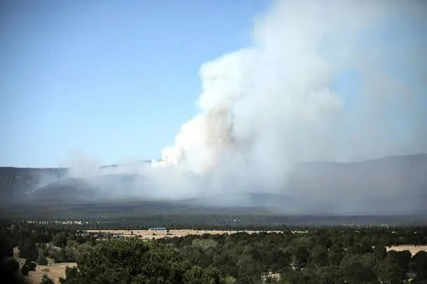
Illinois gets a foot of rain, the U.S.’s 3rd 1,000-year rain in 1 week
Ben Adler, Senior Editor – August 3, 2022
The United States saw its third 1-in-1,000-year rain in a week on Monday night and Tuesday morning, as southern Illinois was drenched by 8 to 12 inches of rain in 12 hours. An area just south of Newton, Ill., recorded 14 inches of rainfall in just 12 hours, according to the National Weather Service. Thunderstorms brought damaging winds and heavy rainfall through midafternoon on Tuesday.
Heavy rain events such as this are becoming more common due to climate change.
The NWS office in Lincoln, Ill., received about 20 reports of flooding on Tuesday as roads turned into rivers. Several flash flood warnings were issued in the region.
Roughly 30,000 customers of CenterPoint Energy in the Evansville, Ill., area lost power on Tuesday, and more than 2,000 were still without power as of noon Central time on Wednesday.
The extraordinarily heavy rain in Illinois comes on the heels of similar events in Kentucky and Missouri. Record-breaking rainfall caused flash flooding in the St. Louis area last Tuesday, trapping cars, closing roads and causing at least one death. Last Thursday, rural areas of eastern Kentucky were flooded after receiving up to 14 inches of rainfall. The death toll, at the most recent count, stood at 37.
Although more rain actually fell in Illinois on Tuesday morning — a foot in the area southeast of Springfield, Ill., for example — the flooding was worse in St. Louis because urbanized areas are more heavily paved and less able to absorb water.
One-day observed precipitation on Tuesday. (National Weather Service)
All three inundations are considered 1,000-year rain events because the amount of rain that fell during such a short window has only a 0.1% chance of happening in any given year.
But that was before climate change. Due to rising concentrations of heat-trapping gases, mainly from the combustion of fossil fuels, the global average temperature has increased by 1.1 degrees Celsius (2 degrees Fahrenheit) since the dawn of the Industrial Revolution. With each degree Celsius of increased temperature, the air can hold 7% more moisture. Therefore, unusually heavy rains are becoming more frequent and severe.
This is especially true in the already-wet Northeast and Midwest. Last year, the Detroit area got 6 inches of rain in June and 8 inches in August, flooding basements and cars, and Hurricane Ida dumped more than 3 inches of rain on New York City in just one hour, resulting in flooding that killed 11 people and shut down the subway system.
China warns that its temperatures are rising faster than global average
August 3, 2022
The Wider Image: The thaw of the Third Pole: China’s glaciers in retreat
A tree stands on the dried-up riverbed of Ai River in Dandong
SHANGHAI (Reuters) – China’s average ground temperatures have risen much more quickly than the global average over the past 70 years and will remain “significantly higher” in the future as the challenges of climate change mount, a government official said.
In its annual climate assessment published this week, China’s weather bureau described the country as “a sensitive region in global climate change”, with temperatures rising 0.26 degrees Celsius (0.47 degrees Fahrenheit) a decade since 1951, compared to the global average of 0.15 degrees.
“In the future, the increase in regional average temperatures in China will be significantly higher than the world,” said Yuan Jiashuang, vice-director of China’s National Climate Center (NCC), at a Wednesday briefing.
He warned that changing weather patterns in China will affect the balance of water resources, make ecosystems more vulnerable and reduce crop yields.
Extreme weather has wreaked havoc in recent weeks, with lengthy heatwaves causing droughts and forest fires across the world. Historically high rainfall in some countries has also caused deadly floods.
U.N. Secretary General Antonio Guterres warned last month that “no nation is immune” from climate change and said the world now had to choose between “collective action or collective suicide”.
China has already endured weeks of torrid weather, with temperatures reaching in excess of 44C (111F) in southwestern Yunnan and Hebei in the north.
As many as 131 Chinese weather stations have recorded temperatures that equalled or exceeded historical highs, up from 62 for the whole of last year, according to NCC data.
China’s 2021 climate assessment said coastal water levels last year were at their highest since 1980. Glacial retreat also accelerated, active permafrost along the Qinghai-Tibet Highway reached a record high and sea ice continued to decline.
China also recorded a 7.9% increase in vegetation cover in 2021 compared to the 2001-2020 average, and the assessment noted growth periods for many plants are starting earlier each year.
(Reporting by David Stanway; Editing by Tom Hogue)
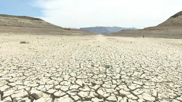
Western U.S. faces water and power shortages due to climate change, U.N. warns
Ben Adler, Senior Editor – August 2, 2022
The two largest reservoirs in the United States are at “dangerously low levels,” threatening the supply of fresh water and electricity in six states and Mexico, the United Nations Environment Programme (UNEP) warned on Tuesday.
Lake Mead and Lake Powell, which are both man-made reservoirs on the Colorado River, are currently at their lowest levels ever, in part because of an ongoing drought exacerbated by climate change.
“The conditions in the American West which we’re seeing around the Colorado River basin have been so dry for more than 20 years that we’re no longer speaking of a drought,” said Lis Mullin Bernhardt, an ecosystems expert at UNEP. “We refer to it as ‘aridification’ — a new, very dry normal.”
The river is also struggling thanks to overconsumption due to a growing population and an outdated agreement that guarantees allotments for its neighboring states. The reservoirs provide water for agricultural and residential use in Arizona, California, Colorado, Wyoming, Nevada and New Mexico.
If conditions don’t improve, Lake Mead and Lake Powell are at risk of reaching “dead pool” status, in which the water is so low it stops flowing out of a reservoir. That would disable the hydroelectric dams that help provide power for millions of residents of the western U.S.
“We are talking about a 20-year period of droughtlike conditions, with an ever-increasing demand on water,” Bernhardt said. “These conditions are alarming, and particularly in the Lake Powell and Lake Mead region, it is the perfect storm.”
The Hoover Dam water intake towers at Lake Mead on July 12 near Boulder City, Nev. (George Rose/Getty Images)
The falling water levels have been a concern for U.S. officials for some time. In June, Bureau of Reclamation Commissioner Camille Calimlim Touton told the Senate Energy and Natural Resources Committee that maintaining “critical levels” at Lake Mead and Lake Powell would require significant reductions in water deliveries.
“What has been a slow-motion train wreck for 20 years is accelerating, and the moment of reckoning is near,” John Entsminger, general manager of the Southern Nevada Water Authority, said at the Senate hearing.
Due to the declining water levels in Lake Mead, which is near Las Vegas, three dead bodies long buried under the water have recently been exposed.
Some water use restrictions have already been put in place. The Metropolitan Water District of Southern California instituted emergency water curtailments in June, typically limiting outdoor watering to one or two days per week.
A sunken boat, now high and dry, on Saddle Island on July 28 in the Lake Mead National Recreation Area, Nev. (Ethan Miller/Getty Images)
The drought in the West has had a number of effects in recent years, including unusually bad wildfire seasons.
Climate scientists say disruptions to the water cycle, especially drought, will become more common as a result of rising global temperatures.
Will Texas run out of groundwater? Experts explain how drought taps out water wells.
Dalia Faheid – August 1, 2022
Water levels in wells across Texas are running low because of the extreme drought, groundwater experts say.
Drought conditions in the state are getting worse by the week. As of July 28, 97% of Texas was in a drought, affecting 24.1 million Texans, per the U.S. Drought Monitor.
“A lot of public supply wells and a lot of even domestic wells have started going dry,” Natalie Ballew, director of the groundwater division at the Texas Water Development Board, told the Star-Telegram.
Many communities, specifically in Central Texas, are experiencing significant water supply issues and they’re having to truck water in from other places, Ballew said. That includes areas like Concan and Utopia in Uvalde County, and Leakey in Real County. That’s causing a myriad of issues for those residents, with ranchers going as far as selling off their cattle because they don’t have water for them.
In North Texas, because people pump more water in the summer, groundwater levels usually start falling around April or May and then come back up in September. Because of the drought, that decline has become much steeper this summer, says Doug Shaw, general manager at the Upper Trinity Groundwater Conservation District. The district serves the counties of Hood, Montague, Parker and Wise.
In one area where levels are measured in real-time, Peaster in Parker County, water levels from July 2 to 24 fell 1.75 feet. Usually, the water level in that region will decline that much over the entire summer, instead of in just a few weeks. That could be indicative of a larger decline in the water table, Shaw says.
MIke Massy stands next to an old water well on his ranch in Hood County that dried up. Massey said he drilled a new well a few feet away that has worked for years.
What are the signs that a water well is impacted by drought?
Water levels decline for two reasons, Ballew says. The first is in drought conditions, when water levels decline because we depend on rainfall to infiltrate down into our aquifers and refill them. Another way a water well can run low is from pumping in surrounding areas. If you have increased pumping going on in one location, that’s going to decrease the water level of that well, as well as impact nearby wells.
How can you tell if your well level is declining because of your neighbor’s increased pumping, extreme drought conditions, or both?
“If you’re kind of out in the middle of nowhere and you don’t have a bunch of pumping going on from irrigation and you’re seeing your water level decline, that could be an indication that it’s drought related,” Ballew explained. It also depends on how far down your well goes. If you have a shallow well located near a river, and your water level runs low, you can assume it’s related to the drought.
With extreme drought, water wells can run dry. You can tell your water well is running dry when your pump isn’t working well or if your water quality is poor, Ballew says. You might start to notice a lot more sand, sediment or air in the pump, Shaw says.
To have enough coverage for a typical well, you should have about 40 to 100 feet of water above the pump, Shaw says.
Can I drill a well on my property?
Texas operates under what’s called a “rule of capture,” which means if you own the land, you can drill a well there. If you’re located within a groundwater conservation district, however, you’ll have to abide by their regulations on groundwater withdrawal. That may include getting a permit to drill the well, registering the well with the district, and/or getting a production permit so that they can manage how much is getting pumped out. In Texas, there are 98 of these districts, covering nearly 70% of the state, according to the Texas Water Development Board.
All wells drilled after Oct. 1, 2010, must be registered.
Unless exempt, you’ll need to get an operating permit from the district prior to drilling, construction or operating of the well. An exempt well is a well that is not a public water supply well and not capable of producing more than 17.36 gallons per minute or is used solely for domestic, livestock, poultry, or agricultural purposes. A non-exempt well is a well capable of producing more than 17.36 gallons per minute, and must submit semi-annual water well production reports to the District at a rate of $0.155 per 1,000 gallons.
For non-exempt wells, you’re required to report groundwater production no later than Jan. 31 and July 31 for the previous 6-month periods each year.
A person who drilled, deepened, completed or otherwise altered a well shall, within 60 days after the date the well is completed, file a well report.
If you do plan on drilling a well on your property, make sure you have a licensed water well driller do it, Ballew says, as they’re often familiar with the groundwater resources in the area.
Can you use well water during a drought?
While you can still use water from a well even if the level has dropped, conserving the water during a drought should be a priority so that it doesn’t run dry.
“In times of drought, when people with private wells or public water supply wells are pumping more and more often, then you never get this opportunity for the wells to kick off and the water levels to come back up,” Shaw says. “And then so what that does is over a larger area, you will see a decline in the water table.”
Eighty to 90% of the groundwater produced is used for lawn irrigation. To conserve, minimize outdoor water tools like sprinklers. Instead, use a soaker hose or another efficient tool to water your yard, Shaw says.
To find out if your water level is running low, you can get your well sampled by your local groundwater conservation district every three months at no charge.
How long does it take a well to replenish water?
The good news — once we get rain, wells that have gone dry do rebound. “It’s not going to be dry forever,” Ballew says.
But how quickly wells replenish after the dry season can vary. Some aquifers, like the Edwards Aquifer In Central Texas, respond really quickly to precipitation.
For other aquifers, like the sand-based Upper Trinity Aquifer, it takes time for the rainfall to actually get down into it, so you would need much more consistent rain. There has to be complete saturation before water passes into the aquifer, Shaw says. Water levels will rebound, however, when people aren’t pumping as much water, usually around wintertime.
“Right now what we’re seeing is a seasonal decline. Water levels are dropping as water is moving from the aquifer towards pumping centers, towards areas where a lot of water is being pumped,” Shaw said. “Once we get to a time of the year where people aren’t watering their lawns, there is less water traveling towards the pumping centers, you will see water levels come back up.”
Although rain is the easiest way to replenish the water, there are two other long-term solutions. One way is through a “managed aquifer recharge,” which floods an area with water using a different source like surface water and lets it infiltrate down into the aquifer. Another is aquifer storage and recovery, where you take water, pump it down into an aquifer and store it for later use.
What causes wells to run dry?
Shaw says we’ll likely see a lot more wells going dry this year. There are a number of reasons why your well may go dry, and they’re more pronounced this summer with the amount of pumping and the drought.
“As far as people’s wells going dry and having to replace their wells, it could be a situation a lot of it is maybe the well was drilled 20, 30, 40 years ago, and water levels were significantly higher than they are now. And so the well had plenty of water in it and now it doesn’t,” Shaw says. “You see another scenario where maybe the well just wasn’t drilled deep enough to begin with, maybe they didn’t fully penetrate the aquifer when they drilled the well, so it never had enough coverage or water above the pump. But this year has been extra stressful on the pump, and maybe it wasn’t able to keep up.”
If your water well runs dry, try to drill deeper into your existing well. If you can’t get any water that way, you’ll have to drill a new well elsewhere. In some instances, you may be able to drill just a mile away, but that may not work in all areas. Or you may need a smaller pump so that there’s enough water above the pump, Shaw says. Reach out to your county or local groundwater conservation district to get some assistance, Ballew recommends.
Wildfires in West explode in size amid hot, windy conditions
Julie Watson and Rebecca Boone – July 30, 2022
SAN DIEGO (AP) — Wildfires in California and Montana exploded in size overnight amid windy, hot conditions and were quickly encroaching on neighborhoods, forcing evacuation orders for over 100 homes Saturday, while an Idaho blaze was spreading.
In California’s Klamath National Forest, the fast-moving McKinney fire, which started Friday, went from charring just over 1 square mile (1 square kilometer) to scorching as much as 62 square miles (160 square kilometers) by Saturday in a largely rural area near the Oregon state line, according to fire officials. The fire burned down at least a dozen residences and wildlife was seen fleeing the area to avoid the flames.
“It’s continuing to grow with erratic winds and thunderstorms in the area and we’re in triple digit temperatures,” said Caroline Quintanilla, a spokeswoman at Klamath National Forest.
California Gov. Gavin Newsom declared a state of emergency Saturday as the fire intensified. The proclamation allows Newsom more flexibility to make emergency response and recovery effort decisions and access federal aid.
It also allows “firefighting resources from other states to assist California crews in battling the fires,” according to a statement from the governor’s office.
Meanwhile in Montana, the Elmo wildfire nearly tripled in size to more than 11 square miles (about 28 square kilometers) within a few miles of the town of Elmo. Roughly 200 miles (320 kilometers) to the south, Idaho residents remained under evacuation orders as the Moose Fire in the Salmon-Challis National Forest charred more than 67.5 square miles (174.8 square kilometers) in timbered land near the town of Salmon. It was 17% contained.
A significant build-up of vegetation was fueling the McKinney fire, said Tom Stokesberry, a spokesman with the U.S. Forest Service for the region.
“It’s a very dangerous fire — the geography there is steep and rugged, and this particular area hasn’t burned in a while,” he said.
A small fire was also burning nearby, outside the town of Seiad, Stokesberry said. With lightning predicted over the next few days, resources from all over California were being brought in to help fight the region’s fires, he said.
McKinney’s explosive growth forced crews to shift from trying to control the perimeter of the blaze to trying to protect homes and critical infrastructure like water tanks and power lines, and assist in evacuations in California’s northernmost county of Siskiyou.
Deputies and law enforcement were knocking on doors in the county seat of Yreka and the town of Fort Jones to urge residents to get out and safely evacuate their livestock onto trailers. Automated calls were being sent to land phone lines as well because there were areas without cell phone service.
Over 100 homes were ordered evacuated and authorities were warning people to be on high alert. Smoke from the fire caused the closure of portions of Highway 96.
The Pacific Coast Trail Association urged hikers to get to the nearest town while the U.S. Forest Service closed a 110-mile (177-kilometer) section of the trail from the Etna Summit to the Mt. Ashland Campground in southern Oregon.
Oregon state Rep. Dacia Grayber, who is a firefighter, was camping with her husband, who is also in the fire service, near the California state line when gale-force winds awoke them just after midnight.
The sky was glowing with strikes of lightening in the clouds, while ash was blowing at them, though they were in Oregon, about 10 miles (about 16 kilometers) away. Intense heat from the fire had sent up a massive pyrocumulonimbus cloud, which can produce its own weather system including winds and thunderstorms, Grayber said.
“These were some of the worst winds I’ve ever been in and we’re used to big fires,” she said. “I thought it was going to rip the roof top tent off of our truck. We got the heck out of there.”
On their way out, they came across hikers on the Pacific Coast Trail fleeing to safety.
“The terrifying part for us was the wind velocity,” she said. “It went from a fairly cool breezy night to hot, dry hurricane-force winds. Usually that happens with a fire during the day but not at night. I hope for everyone’s sake this dies down but it’s looking like it’s going to get worse.”
In western Montana, the wind-driven Elmo fire forced evacuations of homes and livestock as it raced across grass and timber, according to The National Interagency Fire Center, based in Idaho. The agency estimated it would take nearly a month to contain the blaze.
Smoke shut down a portion of Highway 28 between Hot Springs and Elmo because of the thick smoke, according to the Montana Department of Transportation.
Crews from several different agencies were fighting the fire on Saturday, including the Confederated Salish and Kootenai Tribes Fire Division. Six helicopters were making drops on the fire, aided by 22 engines on the ground.
In Idaho, more than 930 wildland firefighters and support staff were battling the Moose fire Saturday and protecting homes, energy infrastructure and the Highway 93 corridor, a major north-south route.
A red flag warning indicated that the weather could make things worse with the forecast calling for “dry thunderstorms,” with lightning, wind and no rain.
In Hawaii, fire crews and helicopters have been fighting flames Saturday evening on Maui near Paia Bay. The Maui County Emergency Management Agency said roads have been closed and have advised residents and travelers to avoid the area. It is unclear how many acres have burned. A red flag warning is in effect Sunday.
Meanwhile, crews made significant progress in battling another major blaze in California that forced evacuations of thousands of people near Yosemite National Park earlier this month. The Oak fire was 52% contained by Saturday, according to a Cal Fire incident update.
As fires raged across the West, the U.S. House on Friday approved wide-ranging legislation aimed at helping communities in the region cope with increasingly severe wildfires and drought — fueled by climate change — that have caused billions of dollars in damage to homes and businesses in recent years.
The legislative measure approved by federal lawmakers Friday combines 49 separate bills and would increase firefighter pay and benefits; boost resiliency and mitigation projects for communities affected by climate change; protect watersheds; and make it easier for wildfire victims to get federal assistance.
The bill now goes to the Senate, where California Democratic Sen. Dianne Feinstein has sponsored a similar measure.
Climate scientist says total climate breakdown is now inevitable: ‘It is already a different world out there, soon it will be unrecognizable to every one of us’
Katherine Tangalakis-Lippert – July 30, 2022
Rich nations are likely to delay action on climate change.peepo/Getty Images
In his new book, Bill McGuire argues it’s too late to avoid catastrophic climate change.
The Earth science professor says lethal heatwaves and extreme weather events are just the beginning.
Many climate scientists, he said, are more scared about the future than they are willing to admit in public.
In his new book published Thursday, “Hothouse Earth: An Inhabitant’s Guide,” Bill McGuire argues that, after years of ignoring warnings from scientists, it is too late to avoid the catastrophic impacts of climate change.
The University College London Earth sciences professor pointed to a record-breaking heatwave across the UK this month and dangerous wildfires that destroyed 16 homes in East London as evidence of the rapidly changing climate. McGuire says weather will begin to regularly surpass current extremes, despite government goals to lower carbon emissions.
“And as we head further into 2022, it is already a different world out there,” McGuire told The Guardian. “Soon it will be unrecognizable to every one of us.”
His perspective — that severe climate change is now inevitable and irreversible — is more extreme than many scientists who believe that, with lowered emissions, the most severe potential impacts can still be avoided.
McGuire did not immediately respond to Insider’s request for comment.
Many climate scientists, McGuire said, are much more scared about the future than they are willing to admit in public. He calls their reluctance to acknowledge the futility of current climate action “climate appeasement” and says it only makes things worse.
Instead of focusing on net-zero emission goals, which McGuire says won’t reverse the current course of climate change, he argues we need to adapt to the “hothouse world” that lies ahead and start taking action to try to stop material conditions from deteriorating further.
“This is a call to arms,” McGuire told The Guardian: “So if you feel the need to glue yourself to a motorway or blockade an oil refinery, do it.”
Las Vegas, NM declares emergency, with less than 50 days of clean water supply left
Nadine El – Bawabn – July 29, 2022
The city of Las Vegas has declared an emergency over its water supply after the Calf Canyon-Hermits Peak Fire, the largest wildfire in New Mexico history, contaminated the Gallinas River. The city relies solely on water from the river, which has been tainted with large amounts of fire-related debris and ash, according to city officials.
New Mexico Gov. Michelle Grisham said in a tweet that $2.25 million in state funding has been made available to ensure residents receive access to safe drinking water.
The city is currently relying on reservoirs which, at the current consumption rate, contain less than 50 days worth of stored water, according to Las Vegas Mayor Louie Trujillo.
PHOTO: A gauge measures water levels on the Rio Nambe amid extreme drought conditions in the area on June 3, 2022 near Nambe, N.M. According to the U.S. Drought Monitor, 90 percent of New Mexico is experiencing extreme drought conditions. (Mario Tama/Getty Images, FILE)
The large amounts of ash and turbidity in the river have prevented the city from being able to pull water from it, as the city’s municipal water treatment facility is not able to treat the contaminated water, according to the mayor.
Related video: NASA releases startling image of Lake Mead shrinkage
0:04 1:48 NASA releases startling image of Lake Mead shrinkage for some 40 million Americans. Scroll back up to restore default view.
The Hermit’s Peak Fire and Calf Canyon Fire merged on April 27. By May 2, the blaze had grown in size and caused evacuations in multiple villages and communities in San Miguel County and Mora County.
PHOTO: Smoke billows from the Hermits Peak and Calf Canyon fire, outside of Las Vegas, N.M., May 11, 2022. (Adria Malcolm/Reuters, FILE)
President Joe Biden issued a major disaster declarations for the New Mexico counties of Colfax, Mora and San Miguel on May 4.
The fire resulted in the loss of federal, state, local, tribal and private property including thousands of acres of the watershed for the Gallinas River, the primary source of municipal water for the city and surrounding areas, according to the emergency declaration.
The Gallinas River has resulted in thousands of acres of scorched forest, flooding, ash and fire debris.
We created scorching ‘heat islands’ in East Coast cities. Now they’re becoming unlivable
Joyce Chu, Eduardo Cuevas and Ricardo Kaulessar – July 27, 2022
Thelma Mays couldn’t breathe.
On a blazing summer day, she began gasping for air inside her Petersburg, Virginia, apartment, and was forced to call 911. If she’d been able to look out her window to see the ambulance pull up at Carriage House, an income-based complex for the elderly, she wouldn’t have been able to see a single tree. Just the other side of the sprawling brick building.
Tanisha Garner stands in front of a former beer plant while a plane passes overhead. The building is among the many structures that trap heat and contribute to high temperatures for residents of Newark’s Ironbound section. July 1, 2022.
When it is too hot to go outside on city streets, the indoors can be just as dangerous for her lung condition, if she gulps refrigerated air for a precious few minutes in front of the AC vent. Mays, 78, has chronic obstructive pulmonary disease, and a quick shift in humidity or temperature can trigger a respiratory emergency.
These days in central Virginia, trapped on the edge of a hotter-than-normal part of an often-overlooked majority Black city, escalating heat and weather patterns are putting Mays and others under health and financial stress. It’s pressure not yet being felt equally in wealthier, majority white suburban areas of the state with landscaped gardens and plentiful indoor cool spaces.
Thelma Mays, 78, has chronic obstructive pulmonary disease. Everyday, she uses a machine to help her breathe. When it gets too hot or too cold, it triggers her wheezing and coughing spasms, sending her to the hospital.
Mays was transported to the emergency room that day.
Doctors worked for hours to stabilize her breathing, giving her IV steroids to help her lungs function.
Stranded on an urban heat island, many don’t survive
The Carriage House apartment complex has a few small trees by the sidewalk, none big enough to provide cover for a single person.
By contrast, Walnut Hill — one of the wealthiest and most tree-lined parts of the city — was more than 13 degrees cooler in the shade. Large trees create an arching canopy over the streets. Nearly every house has wide lawns skirted by mature shade-providing trees. Even in the sun, it was 6 degrees cooler than in Old Towne.
Temperatures in Old Towne outside the Carriage House, where Thelma Mays lives, were more than 6 degrees hotter than one of the most tree-lined areas of the city on a scorching July afternoon.
Old Towne is the hottest area in Petersburg based on 2021 heat-mapping.
Even on hot days, Mays uses her walker to reach the other side of the street where she can sit under the shade of a couple of small trees by a parking lot. She hates being cooped up in her apartment.
Blocks of shops and long treeless stretches of asphalt and concrete trap the heat in Old Towne. On a sweltering July afternoon, we recorded field temperatures at a scorching 101 degrees. Unlike in the West, this level of heat on the East Coast is often accompanied by moisture in the air.
Temperatures in Old Towne outside the Carriage House where Thelma Mays lives was more than 6 degrees hotter than one of the most tree-lined areas of the city on a scorching July afternoon.
“When you have very high humidity, your body can’t evaporate your sweat off of your skin,” said Jeremy Hoffman, the David and Jane Cohn Scientist at the Science Museum of Virginia. “It’s very difficult to cool off naturally. You really need additional help.”
Walnut Hill, one of the most tree-lined and wealthiest neighborhoods in Petersburg, was 6 degrees cooler in the shade than Old Towne, the hottest part of the city with minimal trees.
A difference of a few degrees in extreme heat can affect the body’s ability to regulate its temperature. Some emergency rooms will put out extra gurneys in anticipation of more patients who’ll come in with syncope, respiratory illnesses or heart failure.
Thelma Mays recovered and her granddaughter drove her home. Others in her situation are not so lucky.
Heat death in East Coast cities
We looked at heat islands during an extensive USA TODAY Network reporting project called “Perilous Course,” a collaborative examination of how people up and down the East Coast are grappling with the climate crisis. Journalists from more than 30 newsrooms from New Hampshire to Florida are speaking with regular people about real-life impacts, digging into the science and investigating government response, or lack of it.
Death on a heat island is not as visible or cinematic as the dramatic images of homes crushed by a hurricane, belongings washed away and trees bent by the wind. The elderly and young children fall victim to excessive heat in their homes or inside of cars, away from the public eye and the flashy news headlines.
Hurricanes are short-lived phenomena which are often predicted weeks in advance. Heat’s different. It can come as a heat wave, which can last for days and have no set, predictable spatial boundaries. It enhances conditions on the ground which absorb the heat.
“A heat wave is very hard to define in space and time,” said Hoffman. “It’s not something that you can see on the map; it is something that you feel in the outdoors. So, we have a crisis of communication around heat.”
Climate change has exacerbated the intensity of heat waves, the number of excessive heat days per year and the length of these heat waves. The average length of a heat wave season in 50 big cities studied is now around 70 days, compared to 20 days back in the 1960s. In less than one lifetime, the heat wave season has tripled.
In some places, summer can feel like one long heat wave.
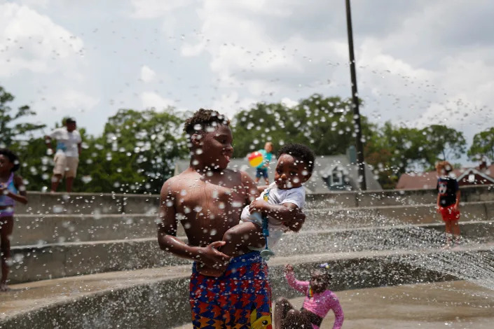
Children cool off in the spray area at Hull Park on Tuesday June 14, 2022 as the heat index climbed over 100 for the second straight day.
The warming climate has been tied to increased mortality around the world. In a large-scale study that examined heat in 43 countries, including the U.S., researchers found that 37 percent of heat-related deaths could be attributed to the climate crisis.
Extreme heat can be more dangerous for those in the Northeastern United States.
“What becomes really dangerous in these more northern cities is that they haven’t yet adopted air conditioning very widely yet,” Hoffman said. “And especially in lower income and communities of color or immigrant communities, prevalence of air conditioning utilization is very low.”
Three of the country’s nine least-air-conditioned cities are in the Northeastern states — Providence, Rhode Island; Hartford, Connecticut; and Buffalo, New York, according to U.S. Census bureau data and a USA TODAY report.
In Florida, researchers have been measuring the impact of heat islands.
The National Oceanic and Atmospheric Administration has conducted studies in West Palm Beach and Jacksonville, sometimes using volunteers to capture data. Its studies have indicated that low-income neighborhoods in Florida have less ability to cope with the damaging results of manmade heat islands.
A nonprofit research group called Climate Central found that Jacksonville’s heat island was potentially raising the overall average temperature of the entire city by as much as 6 degrees.
The “feels like” temperature or heat index can make a major difference for people living in humid places like Florida.
On 58th Street in West Palm Beach on a block barren of shade trees it reached 93.9 degrees near noon on July 22 with a relative humidity of 58%. That means it felt like 106 degrees.
“My electric bill was almost two-fold in June from what it was in March,” said 27-year-old Varun Parshad. “I try to be more disciplined with the temperature settings.”
Six miles to the southwest, the National Weather Service’s official gauge at Palm Beach International Airport registered 88 degrees with a lower feels-like temperature of 100 degrees.
The difference between 58th Street and the airport is significant enough when meteorologists and emergency officials have to make heat-related decisions, and it’s something some cities are recognizing as they plan for a warmer future.
No matter what part of the East Coast you’re in, things are getting hotter and more dangerous.
Extreme heat affects low-income communities and people of color on a greater scale due to structural inequities. From 2005 to 2015, the number of emergency room visits increased by 67% for Black people, 63% for Hispanic people and 53% for Asian Americans, compared to 27% for whites.
The conditions for heat to become deadly in certain places were set into motion decades ago by people who were very aware of race. As Hoffman himself would discover, those intentional decisions led to unintentional consequences in the present.
Discrimination made East Coast neighborhoods worse
In Petersburg, to the west of Thelma Mays’ apartment, there is an empty lot that dates back to colonial America and has housed a trading post, tobacco stemmery and Civil War prison in a town that had the highest percentage of African Americans of any in the Confederacy.
The block that remains has grass and some shady trees, and money has been spent on history signage and the stabilization of a crumbling wall. But there are not municipal improvements that give anyone who lives nearby many options to sit and use the shady space during the suffocating summer.
Hundreds of miles north from Thelma Mays’ apartment, there’s another woman who can’t stay indoors when the sun comes up in summer.
Several streets in Brianna Rodriguez’s Nodine Hill neighborhood in Yonkers, New York, are named for trees. But few trees actually line the sidewalks, and there aren’t many parks.
Brianna Rodriguez, a recent Yonkers High graduate, grew up playing in the playground at School 23 in Yonkers. Working with Groundwork Hudson Valley she has realized that her old playground is one of the hottest spots in Yonkers July 1, 2022.
“I couldn’t just stay in my room,” she said about the July 4 holiday weekend. Unable to afford AC units, Rodriguez’s family goes outside instead, to try to find a park to cool off.
When they have to be inside, three industrial fans normally used to quickly dry paint circulate air toward the center of Rodriguez’s living room in Yonkers. But even on full blast, they can’t cool the 18-year-old, her mom, stepdad and their dog inside their third-floor apartment.
There isn’t much shade throughout the working-class Black and Latino neighborhood. Rodriguez avoids certain streets she knows would be too hot between rows of taller apartment buildings and scalding pavement and asphalt.
The characteristics of the neighborhood Rodriguez lives in — residential areas with little or no parks or tree-shade, often bordered by industrial areas, warehouses or bisected by highways and overpasses — are the material remnants of an economic rating system nearly a hundred years old that disincentivized mortgage loans and devalued property.
The creation of “undesirable” economic districts by the government and banks isolated parts of the city populated by non-white people. Those “redlined districts” and the neglect of those areas that followed created the conditions which studies are now proving to be dangerous for human health amid the climate crisis that has already arrived.
Maps of city heat islands are a deadly mirror of redlined neighborhoods
In July 2017, Jeremy Hoffman set out to map Richmond, Virginia, using a new heat-tracking methodology developed by his colleague Vivek Shandas.
Someone told Hoffman that his heat map looked a lot like a map of Richmond’s redlined districts, which Hoffman didn’t know much about at that time. When he compared them, they looked almost identical.
He went to Baltimore, Boston and Washington, D.C., to gather temperatures. The results of the heat maps again matched up with the redlined maps of each city.
That next summer, Hoffman gathered surface temperatures through satellite imaging in each of the 250 redlined cities to see if the heat islands correlated with previously redlined areas, available through historical maps.
“Cities don’t happen by accident,” Hoffman said. “Our neighborhoods don’t happen by accident. Everything is a decision that’s been made. Every single second of your daily life in a city is the integrated outcome of all the historical planning policies and decisions that were made before that.”
From left, Candida Rodriguez, with Groundwork Hudson Valley, Brianna Rodriguez, a recent Yonkers High graduate, and Brigitte Griswold, Groundwork Hudson Valley CEO, talk about the heat in the area of Getty Square in Yonkers July 1, 2022.
A harsh but telling example: Maps made by the Home Owners’ Loan Corporation described Nodine Hill, then heavily Italian, as “hazardous,” a September 1937 form said. Its detrimental influences, the form said, were aging buildings and the “character of occupants.”
On average, a person of color lives in a census tract with higher surface urban heat island intensity than non-Hispanic white people in all but six of the 175 largest urbanized areas in the U.S., according to a 2021 study published in the science journal Nature Communications.
Black residents had the most exposure to heat islands, researchers said, followed by Hispanic people.
The underlying conditions for heat islands were set decades ago by the economic isolation of redlining. Climate change just catalyzed these places to make them even more dangerous to human life.
Absorbing the history of heat
As a young child, Rodriguez didn’t play on the swings at her Nodine Hill elementary school on the hottest days, though they were her favorite part of the playground.
At recess, she skirted School 23’s playground, built on a black rubber mat over concrete, and joined hundreds of students huddled under a few trees. The sun glared directly down on the swings’ metal links, making them too hot to hold onto.
A photo Brianna Rodriguez, 18, took of her elementary school’s playground in the Nodine Hill neighborhood of Yonkers, New York. Rodriguez was capturing images in urban heat islands for her work with the environmental justice nonprofit Groundwork Hudson Valley.
“I had always felt that it was hotter,” Rodriguez said on a recent Friday afternoon in the shadow of her old school, a large brick building for pre-K-8 students built in 1918. “It was just evident to me.”
Temperatures were in the 90s on July 1, 2022. But Rodriguez felt it was even hotter in Nodine Hill. The neighborhood is just a mile uphill from the Hudson River, which provides daily breeze for those along the water.
School 23’s playground was nearly empty a week after classes ended. A few teens sat by one of the basketball hoops in the shade. Rodriguez’s gold necklace with her middle name, Brooklyn, glinted in the sun.
On hot days, without shade or greenspace that can cool neighborhoods, fewer people are outside in Southwest Yonkers. Instead, many cluster indoors to keep cool.
Upscale neighborhoods are edged with trees and parks with shaded pathways. In Southwest Yonkers, where Nodine Hill is located, residential areas are edged with unwanted facilities, congested roadways, sewage and wastewater treatment plants, according to Brigitte Griswold, executive director of Groundwork Hudson Valley, an environmental justice nonprofit that’s studied the local effects of redlining.
Resulting air pollution contributes to higher rates of asthma and heart disease in these communities, she added.
Brigitte Griswold, Groundwork Hudson Valley CEO, talks about the daylighting of the Saw Mill River in the Getty Square section of Yonkers July 1, 2022.
Griswold said the self-imposed isolation impedes people from checking on each other during a heat wave.
“It’s kind of a double-edged sword,” she said. “The heat itself prevents that social cohesion from happening. And then that breaks down community resilience to respond to the very thing that is driving people apart.”
Growing development brings more heat
The little growth that has come from the end of redlining is not always welcome or healthy. In these spaces, where land is cheaper and zoning fluid, manufacturing sites, energy plants and big box stores have sprung up.
New Jersey resident Tanisha Garner knows more buildings in her neighborhood mean more heat.
Garner, a Newark native who has lived in an area called the Ironbound for the past four years, said at least 10 projects are being planned for the area — and that they will be built with materials that absorb and radiate heat.
Newark resident Tanisha Garner spoke about the impact of heat in the area and the various factors that contribute to it being one of the hottest areas in a city considered one of the worst heat islands in the United States here in Newark, NJ, on July 1, 2022.
The Ironbound area got its name from the metalworking factories and railroad tracks in the area. For over a hundred years, this eastern section of Newark was home to all kinds of industrial activity. It was also an area redlined back in the late 1930s, classified as “dangerous” and marked by the federal government to be excluded from mortgage eligibility.
Many of those industries are long gone. Others have taken their place. A waste-to-energy incinerator, a sewage treatment plant, a metal plating shop and numerous warehouses. The area has been subject to some of the worst pollution in the state.
Garner thinks these development projects take out greenery and open space and fill them with buildings that help amplify the heat in her neighborhood.
“What creates that heat island? Is it the structure of the building, is it a lack of trees, is it the lack of balance between nature and construction?” Garner said. “When you look at the Ironbound, you can see there is an imbalance.”
During a tour of her neighborhood in July, Garner pointed out some of the areas designated for development.
A thermometer reads 95 degrees in the shade under one of the few trees in this section of Newark, one of the hottest areas in a city considered one of the worst heat islands in the United States here. July 1, 2022.
One of those areas encompasses Freeman and Ferry streets, the future site of a six-story, 280-unit complex to be built at the site of the historic Ballantine Brewery, starting this summer. The current area has no trees lining the sidewalk. A rendering of the proposed project shows numerous trees surrounding the building. Will it be enough to offset the potential heat effect of such a huge structure?
A temperature check of that block at 11:20 a.m. registered 95.7 degrees, six degrees more than the city’s temperature of 89 degrees at that time, according to the website Weather Underground.
Heat island as zombie apocalypse
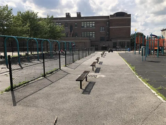
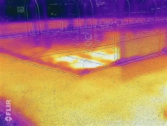
In July 2020, Brianna Rodriguez took her handheld FLIR thermal camera and pointed the bullseye at School 23’s black rubber mat where she once played. It was 88 degrees in Yonkers that day, she noted. Down on the mat, it was 127 degrees.
The infrared camera captured yellow and orange colors around the mat, signaling more surface heat, as opposed to blue and purple meaning cool.
She jotted the reading down in her journal, as part of Groundwork Hudson Valley’s green team, composed of Yonkers teens interested in sustainability and climate change. They were completing an exercise developed by Shandas, where they pretended the heat was a zombie apocalypse affecting her neighborhood. Where it was yellow and orange on the camera, there were more zombies.
The image of her playground looked like the surface of the sun.
The thermal image Brianna Rodriguez, 18, took of her elementary school’s playground swing set in the Nodine Hill neighborhood of Yonkers, New York. Rodriguez was capturing images in urban heat islands for her work with the environmental justice nonprofit Groundwork Hudson Valley. The brighter spots indicate greater heat intensity.
Ultimately, potential solutions for minimizing the deaths from heat islands should be a lot easier than protecting a city from zombies. Shandas, a chronicler of the “heat dome” phenomenon that settled over Portland, Oregon, with deadly results in its hottest neighborhoods last summer, said immediate action can be taken with lifesaving results.
Cities can open more cooling centers during hot days to give residents respite from the heat.
Property managers can do checks on apartments when indoor temperatures soar above 90 degrees.
Planting trees in heat islands can also have an immediate impact that will only grow as increasing canopy creates more shaded area, while adding oxygen to the local atmosphere.
Such changes, Shandas said, can be implemented ahead of more complex structural changes to amend building codes for cooler buildings with walls or roof construction materials that deflect heat.
Tree planting programs have been implemented in many states. But where the trees are planted matters. While thousands of trees have been planted in Newark in the last several years, the agency in charge would not say how many were planted in the Ironbound. Walking through the Ironbound’s streets, it’s hard to think that this area has been targeted for a tree-based solution.
A few years ago in Rhode Island, a young musician-turned-activist noticed a similar lack of new trees being planted in the least shady neighborhoods in places such as South Providence and Central Falls. Kufa Castro worked with local governments and citizens to make sure that over 190 trees were planted in a two-year period in areas with little tree canopy.
Ultimately, Shandas explained, heat islands are manmade and can be managed.
“It goes back to a lot of conditions that have been created by human decision-making processes,” he said. “What we really want to do is try to figure out what are the ways we can unpack some of this and get ahead of it.”
Down the street from School 23, children took turns running past an open fire hydrant that sprayed water into the middle of the street. Scrambling in a ragged line, they screamed with delight as the cool water hit them. Rodriguez had done the same as a kid.
That night, as fireworks sizzled and boomed overhead, the pavement by the hydrant had long since dried in the heat. The heat of the day, held like a memory by the playground’s metal and rubber matting, slowly released into the night.
— Palm Beach Post reporter Kimberly Miller contributed to this story.


 Scroll back up to restore default view.