Deadline looms for drought-stricken states to cut water use

Associated Press

Deadline looms for drought-stricken states to cut water use

Sam Metz and Felicia Fonseca – August 14, 2022

FILE - Visitors view the dramatic bend in the Colorado River at the popular Horseshoe Bend in Glen Canyon National Recreation Area, in Page, Ariz., on Sept. 9, 2011. Some 40 million people in Arizona, California, Colorado, Nevada, New Mexico, Utah and Wyoming draw from the Colorado River and its tributaries. The U.S. Bureau of Reclamation is expected to publish hydrology projections on Tuesday, Aug. 16, 2022, that will trigger agreed-upon cuts to states that rely on the river. (AP Photo/Ross D. Franklin, File)
Visitors view the dramatic bend in the Colorado River at the popular Horseshoe Bend in Glen Canyon National Recreation Area, in Page, Ariz., on Sept. 9, 2011. Some 40 million people in Arizona, California, Colorado, Nevada, New Mexico, Utah and Wyoming draw from the Colorado River and its tributaries. The U.S. Bureau of Reclamation is expected to publish hydrology projections on Tuesday, Aug. 16, 2022, that will trigger agreed-upon cuts to states that rely on the river. (AP Photo/Ross D. Franklin, File)
ASSOCIATED PRESS
FILE - Farmer John Hawk looks over his land as his seed onion fields are watered in Holtville, Calif., Sept. 3, 2002. For the seven states that rely on the Colorado River that carries snowmelt from the Rocky Mountains to the Gulf of California, that means a future with increasingly less water for farms and cities although climate scientists say it's hard to predict how much less. The U.S. Bureau of Reclamation is expected to publish hydrology projections on Tuesday, Aug. 16, 2022, that will trigger agreed-upon cuts to states that rely on the river. (AP Photo/Reed Saxon, File)
Farmer John Hawk looks over his land as his seed onion fields are watered in Holtville, Calif., Sept. 3, 2002. For the seven states that rely on the Colorado River that carries snowmelt from the Rocky Mountains to the Gulf of California, that means a future with increasingly less water for farms and cities although climate scientists say it’s hard to predict how much less. The U.S. Bureau of Reclamation is expected to publish hydrology projections on Tuesday, Aug. 16, 2022, that will trigger agreed-upon cuts to states that rely on the river. (AP Photo/Reed Saxon, File)
ASSOCIATED PRESS
FILE - A boat cruises along Lake Powell near Page, Ariz., on July 31, 2021. Seven states in the U.S. West are facing a deadline from the federal government to come up with a plan to use substantially less Colorado River water in 2023. The U.S. Bureau of Reclamation is expected to publish hydrology projections on Tuesday, Aug. 16, 2022, that will trigger agreed-upon cuts to states that rely on the river. Prolonged drought, climate change and overuse are jeopardizing the water supply that more than 40 million people rely on. (AP Photo/Rick Bowmer, File)
A boat cruises along Lake Powell near Page, Ariz., on July 31, 2021. Seven states in the U.S. West are facing a deadline from the federal government to come up with a plan to use substantially less Colorado River water in 2023. The U.S. Bureau of Reclamation is expected to publish hydrology projections on Tuesday, Aug. 16, 2022, that will trigger agreed-upon cuts to states that rely on the river. Prolonged drought, climate change and overuse are jeopardizing the water supply that more than 40 million people rely on. (AP Photo/Rick Bowmer, File)
ASSOCIATED PRESS
FILE - A home with a swimming pool abuts the desert on the edge of the Las Vegas valley, Wednesday, July 20, 2022, in Henderson, Nev. The U.S. Bureau of Reclamation is expected to publish hydrology projections on Tuesday, Aug. 16, 2022, that will trigger agreed-upon cuts to states that rely on the river. (AP Photo/John Locher, File)
A home with a swimming pool abuts the desert on the edge of the Las Vegas valley, Wednesday, July 20, 2022, in Henderson, Nev. The U.S. Bureau of Reclamation is expected to publish hydrology projections on Tuesday, Aug. 16, 2022, that will trigger agreed-upon cuts to states that rely on the river. (AP Photo/John Locher, File)
ASSOCIATED PRESS
FILE - A formerly sunken boat sits upright into the air with its stern stuck in the mud along the shoreline of Lake Mead at the Lake Mead National Recreation Area, Friday, June 10, 2022, near Boulder City, Nev. Lake Mead water has dropped to levels it hasn't been since the lake initially filled over 80 years earlier. Prolonged drought, climate change and overuse are jeopardizing the water supply that more than 40 million people rely on. States are acknowledging that painful cuts are needed, but also stubbornly clinging to the water they were allocated a century ago. (AP Photo/John Locher, File)
A formerly sunken boat sits upright into the air with its stern stuck in the mud along the shoreline of Lake Mead at the Lake Mead National Recreation Area, Friday, June 10, 2022, near Boulder City, Nev. Lake Mead water has dropped to levels it hasn’t been since the lake initially filled over 80 years earlier. Prolonged drought, climate change and overuse are jeopardizing the water supply that more than 40 million people rely on. States are acknowledging that painful cuts are needed, but also stubbornly clinging to the water they were allocated a century ago. (AP Photo/John Locher, File)
ASSOCIATED PRESS
FILE - The Colorado River flows at Horseshoe Bend in the Glen Canyon National Recreation Area, Wednesday, June 8, 2022, in Page, Ariz. Seven states in the U.S. West are facing a deadline from the federal government to come up with a plan to use substantially less Colorado River water in 2023. The U.S. Bureau of Reclamation is expected to publish hydrology projections on Tuesday, Aug. 16, 2022, that will trigger agreed-upon cuts to states that rely on the river. (AP Photo/Brittany Peterson, File)
The Colorado River flows at Horseshoe Bend in the Glen Canyon National Recreation Area, Wednesday, June 8, 2022, in Page, Ariz. Seven states in the U.S. West are facing a deadline from the federal government to come up with a plan to use substantially less Colorado River water in 2023. The U.S. Bureau of Reclamation is expected to publish hydrology projections on Tuesday, Aug. 16, 2022, that will trigger agreed-upon cuts to states that rely on the river. (AP Photo/Brittany Peterson, File)
ASSOCIATED PRESS
FILE - An aerial view of Lake Powell on the Colorado River along the Arizona-Utah border on Sept. 11, 2019. The U.S. Bureau of Reclamation is expected to publish hydrology projections on Tuesday, Aug. 16, 2022, that will trigger agreed-upon cuts to states that rely on the river. (AP Photo/John Antczak, FIle )
An aerial view of Lake Powell on the Colorado River along the Arizona-Utah border on Sept. 11, 2019. The U.S. Bureau of Reclamation is expected to publish hydrology projections on Tuesday, Aug. 16, 2022, that will trigger agreed-upon cuts to states that rely on the river. (AP Photo/John Antczak, FIle )
ASSOCIATED PRESS

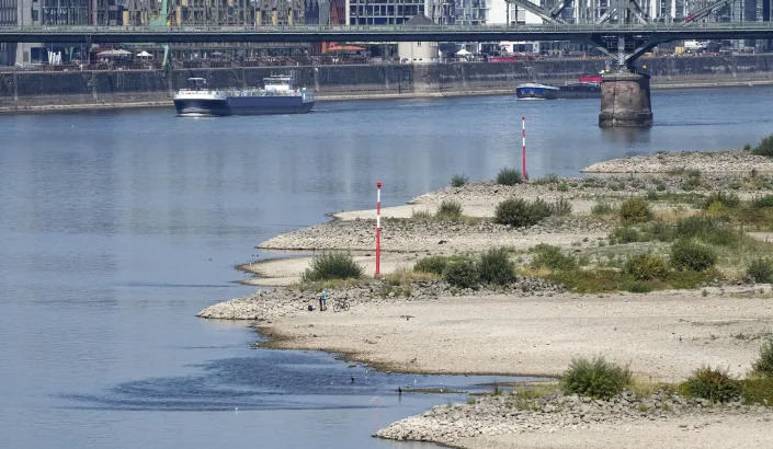
SALT LAKE CITY (AP) — Banks along parts of the Colorado River where water once streamed are now just caked mud and rock as climate change makes the Western U.S. hotter and drier.

More than two decades of drought have done little to deter the region from diverting more water than flows through it, depleting key reservoirs to levels that now jeopardize water delivery and hydropower production.

Cities and farms in seven U.S. states are bracing for cuts this week as officials stare down a deadline to propose unprecedented reductions to their use of the water, setting up what’s expected to be the most consequential week for Colorado River policy in years.

The U.S. Bureau of Reclamation in June told the states — Arizona, California, Colorado, Nevada, New Mexico, Utah and Wyoming — to figure out how to use at least 15% less water next year, or have restrictions imposed on them. On top of that, the bureau is expected to publish hydrology projections that will trigger additional cuts already agreed to.

“The challenges we are seeing today are unlike anything we have seen in our history,” Camille Touton, the bureau’s commissioner, said in a U.S. Senate hearing that month.

Tensions over the extent of the cuts and how to spread them equitably have flared, with states pointing fingers and stubbornly clinging to their water rights despite the looming crisis.

“It’s not fun sitting around a table figuring out who is going to sacrifice and how much,” said Bill Hasencamp, the Colorado River resources manager at Metropolitan Water District, which provides water to most of Southern California.

Representatives from the seven states convened in Denver last week for eleventh-hour negotiations behind closed doors. Officials party to discussions said the most likely targets for cuts are farmers in Arizona and California. Agricultural districts in those states are asking to be paid generously to shoulder that burden.

But the tentative agreements fall short of what the Bureau of Reclamation has demanded and state officials say they hope for more time to negotiate details.

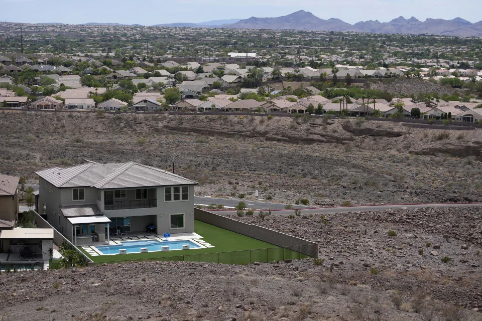
The Colorado River cascades down from the Rocky Mountains into the arid deserts of the Southwest. It’s the primary water supply for 40 million people. About 70% of its water goes toward irrigation, sustaining a $15 billion-a-year agricultural industry that supplies 90% of the United States’ winter vegetables.

The river is divided among Mexico and the seven U.S. states under a series of agreements that date back a century, to a time when more water flowed through the river. But climate change has transformed the river’s hydrology, providing less snowmelt and causing hotter temperatures and more evaporation. As it’s yielded less water, the states have agreed to cuts tied to the levels of reservoirs that store river water.

Last year, federal officials for the first time declared a water shortage, triggering cuts to Nevada, Arizona and Mexico’s share of the river to help prevent the two largest reservoirs — Lake Powell and Lake Mead — from dropping low enough to threaten hydropower production and stop water from flowing through their dams.

The proposals for supplemental cuts due this week have inflamed disagreement between upper basin states — Colorado, New Mexico, Utah and Wyoming — and lower basin states — Arizona, California and Nevada — over how to spread the pain. The lower basin states use most of the water and have thus far shouldered most of the cuts. The upper basin states have historically not used their full allocations but want to maintain their water rights to plan for population growth.

Gene Shawcroft, the chairman of Utah’s Colorado River Authority, believes the lower basin states should take most of the cuts because they use most of the water and their full allocations.

He said it was his job to protect Utah’s allocation for growth projected for decades ahead: “The direction we’ve been given as water purveyors is to make sure we have water for the future.”

In a letter last month, representatives from the upper basin states proposed a five-point conservation plan that they said would save water but argued most of the cuts needed to come from the lower basin. The plan didn’t commit to any numbers.

“The focus is getting the tools in place and working with water users to get as much as we can rather than projecting a water number,” Chuck Cullom, the executive director of the Upper Colorado River Commission, told The Associated Press.

That position, however, is unsatisfactory to many in lower basin states already facing cuts.

“It’s going to come to a head particularly if the upper basin states continue their negotiating position, saying, ‘We’re not making any cuts,’” said Bruce Babbitt, who served as Interior secretary from 2003-2011.

Lower basin states have yet to go public with plans to contribute, but officials said last week that they had a tentative proposal to reduce consumption that fell slightly short of the federal government’s request to cut 2 to 4 million acre-feet.

An acre-foot of water is enough to serve 2-3 households annually.

Hasencamp, the Metropolitan Water District’s Colorado River resource manager, said all the districts in the state that draw from the river had agreed to contribute water or money to the plan, pending approval by their respective boards. Water districts, in particular the Imperial Irrigation District, have been adamant that any voluntary cut does not curtail their high priority water rights.

Southern California cities likely will be putting up money that could fund fallowing farmland in places like Imperial County and water managers are considering leaving water they’ve stored in Lake Mead as part of their contribution.

Arizona will likely be hit hard with reductions. The state has in the past few years shouldered much of the cuts and with its growing population and robust agricultural industry, has less wiggle room than its neighbors to take on more, said Arizona Department of Water Resources Director Tom Buschatzke. Some tribes in Arizona have also contributed to propping up Lake Mead in the past, and could play an outsized role in any new proposal.

Irrigators around Yuma, Arizona, have proposed taking 925,000 acre-feet less of Colorado River water in 2023 and leaving it in Lake Mead if they’re paid $1.4 billion, or $1,500 per acre-foot. The cost is far above the going rate, but irrigators defended their proposal as fair considering the cost to grow crops and get them to market.

Wade Noble, the coordinator for a coalition that represents Yuma water rights holders, said it was the only proposal put forth publicly that includes actual cuts, rather than theoretical cuts to what users are allocated on paper.

Some of the compensation-for-conservation funds could come from a $4 billion drought earmark in the Inflation Reduction Act under consideration in Washington, U.S. Sen. Kyrsten Sinema of Arizona told the AP.

Sinema acknowledged paying farmers to conserve wasn’t a long-term solution: “In the short-term, however, in order to meet our day-to-day needs and year-to-year needs, ensuring that we’re creating financial incentives for non-use will help us get through,” she said.

Babbitt, too, said money in the legislation will not “miraculously solve the problem” and prices for water must be reasonable to avoid gouging because most water users will take a hit.

“There’s no way that these cuts can all be paid for at a premium price for years and years,” he said.

Fonseca reported from Flagstaff, Arizona. Associated Press reporter Kathleen Ronayne contributed from Sacramento, California.

A disastrous ‘megaflood’ flood in sunny and dry California? It’s happened before

USA Today

A disastrous ‘megaflood’ flood in sunny and dry California? It’s happened before

Mike Snider, USA TODAY – August 14, 2022

Grayscale lithograph of K Street in the city of Sacramento, California — during the Great Flood of 1862. The flood affected the Western United States, from Oregon through California, and Idaho through New Mexico.

A new study raises concerns about climate change-fueled floods dropping massive amounts of water on drought-plagued California – an unlikely sounding scenario that has actually happened before.

While intense droughts, wildfires and earthquakes are typically the main concern across the West, the study released Friday warned of another crisis looming in California: “Megafloods.” It notes climate change is increasing the risk of floods that could submerge cities and displace millions of people across the state. It says an extreme monthlong storm could bring feet of rain – in some places, more than 100 inches – to hundreds of miles of California.

While the scenario might sound like something out of a movie, it’s happened before.

California has experienced severe floods throughout the 20th Century, including in 1969, 1986, and 1997. But a flood from farther in the past – the Great Flood of 1862 – is being eyed by researchers as the threat to California grows by the day.

Though it occurred 160 years ago, the flood – deemed a “megastorm” for its historical rainfall covering huge swaths of the state – illustrates that the threat is not merely theoretical.

In fact, the UCLA researchers studying “megafloods” say such storms typically happen every 100-200 years.

Researchers are sounding the alarm because flood of that scale today would have far more devastating impacts in a state that is now the nation’s most populous.

And the Great Flood of 1862 was also preceded by drought.

How bad was the Great Flood of 1862?

Intense rainstorms pummeled central California “virtually unabated” from Christmas Eve 1861 until January 1862, Scientific American chronicled in a 2013 story on “The Coming Megastorms.”

The flow of water created “a huge inland sea …  a region at least 300 miles long,” leaving Central and southern California underwater for up to six months, the magazine said. Floodwaters stretched as wide as 60 miles across, wrote UCLA researchers in their recent flood risk study.

Weather forecast: Heat waves may now get names. The first is Zoe – in Spain

Rainwater study: Study suggests it’s now unsafe to drink worldwide because of ‘forever chemicals’

“Thousands of farms are entirely under water – cattle starving and drowning,” wrote scientist William Brewer (author of “Up and Down California in 1860-1864”) in a letter to his brother, cited by Scientific American. “All the roads in the middle of the state are impassable; so all mails are cut off. The telegraph also does not work clear through. In the Sacramento Valley for some distance the tops of the poles are under water.”

An estimated 4,000 people died and one-third of all property in the state was destroyed, including one-fourth of its 800,000 cattle, which either drowned or starved, wrote the SFGate news site in a retrospective earlier this year.

The Great Flood of 1862 would be much worse if it happened today

The region that was underwater in 1862 is now home to many more people than it was then — it’s home to some of California’s fastest-growing cities including Bakersfield and Sacramento.

Back then, the state’s population was about 500,000, but today it’s nearly 40 million. “Were a similar event to happen again, parts of cities such as Sacramento, Stockton, Fresno and Los Angeles would be under water even with today’s extensive collection of reservoirs, levees and bypasses,” researchers who worked on the flood-risk study released Friday said in a press release.

The resulting disaster would cause an estimated $1 trillion in damage, the biggest disaster in world history, they say.

And the effects would go beyond central and southern California, said Daniel Swain, a UCLA climate scientist and the study’s co-author. “Every major population center in California would get hit at once – probably parts of Nevada and other adjacent states, too,” he said.

Major highways such as Interstate 5, which runs along the Pacific coast from Canada to Mexico, and I-80, which dissects California through San Francisco and Sacramento, would likely be shut down for weeks or months, he said.

The ripple effects would impact global economics and supply chains.

Lightning strikes east of the eastern front of the McKinney Fire, in the Klamath National Forest near Yreka, Calif. on Aug, 2, 2022.
What causes megafloods?

Atmospheric rivers are long water vapor streams formed about a mile above Earth. They can “carry as much water as 10 to 15 Mississippi Rivers from the tropics and across the middle latitudes,” wrote Michael Dettinger, research hydrologist for the U.S. Geological Survey, and Lynn Ingram, a University of California, Berkeley, professor of earth and planetary science, in Scientific American.

When one comes across the Pacific Ocean and hits the Sierra Nevada, “it is forced up, cools off and condenses into vast quantities of precipitation,” they wrote.

Warming temperatures are making extreme storms more likely – with more runoff, researchers say. In a 2018 study, Swain estimated there was a 50-50 chance of a megaflood the size of the Great Flood of 1862 happening again by 2060, Popular Science reported. “It would essentially inundate land that is now home to millions of people,” he said then.

The new research suggests climate change has already doubled the likelihood of extreme storms and each additional degree of global warming increases the likelihood of a megaflood.

Research is continuing on potential flood effects and how to prepare for the them. Keeping the issue alive in the mind of Californians is important because drought, wildfires and earthquakes get all the attention, Swain said.

“There is potential for bad wildfires every year in California, but a lot of years go by when there’s no major flood news,” he said. “People forget about it.”

Northeastern farmers face new challenges with severe drought

Associated Press

Northeastern farmers face new challenges with severe drought

Jennifer McDermott – August 14, 2022

PROVIDENCE, R.I. (AP) — Vermont farmer Brian Kemp is used to seeing the pastures at Mountain Meadows Farm grow slower in the hot, late summer, but this year the grass is at a standstill.

That’s “very nerve-wracking” when you’re grazing 600 to 700 cattle, said Kemp, who manages an organic beef farm in Sudbury. He describes the weather lately as inconsistent and impactful, which he attributes to a changing climate.

“I don’t think there is any normal anymore,” Kemp said.

The impacts of climate change have been felt throughout the Northeastern U.S. with rising sea levels, heavy precipitation and storm surges causing flooding and coastal erosion. But this summer has brought another extreme: a severe drought that is making lawns crispy and has farmers begging for steady rain. The heavy, short rainfall brought by the occasional thunderstorm tends to run off, not soak into the ground.

Water supplies are low or dry, and many communities are restricting nonessential outdoor water use. Fire departments are combatting more brush fires and crops are growing poorly.

Providence, Rhode Island had less than half an inch of rainfall in the third driest July on record, and Boston had six-tenths of an inch in the fourth driest July on record, according to the National Weather Service office in Norton, Massachusetts. Rhode Island’s governor issued a statewide drought advisory Tuesday with recommendations to reduce water use. The north end of the Hoppin Hill Reservoir in Massachusetts is dry, forcing local water restrictions.

Officials in Maine said drought conditions really began there in 2020, with occasional improvements in areas since. In Auburn, Maine, local firefighters helped a dairy farmer fill a water tank for his cows when his well went too low in late July and temperatures hit 90. About 50 dry wells have been reported to the state since 2021, according to the state’s dry well survey.

The continuing trend toward drier summers in the Northeast can certainly be attributed to the impact of climate change, since warmer temperatures lead to greater evaporation and drying of soils, climate scientist Michael Mann said. But, he said, the dry weather can be punctuated by extreme rainfall events since a warmer atmosphere holds more moisture — when conditions are conducive to rainfall, there’s more of it in short bursts.

Mann said there’s evidence shown by his research at Penn State University that climate change is leading to a “stuck jet stream” pattern. That means huge meanders of the jet stream, or air current, get stuck in place, locking in extreme weather events that can alternately be associated with extreme heat and drought in one location and extreme rainfall in another, a pattern that has played out this summer with the heat and drought in the Northeast and extreme flooding in parts of the Midwest, Mann added.

Most of New England is experiencing drought. The U.S. Drought Monitor issued a new map Thursday that shows areas of eastern Massachusetts outside Cape Cod and much of southern and eastern Rhode Island now in extreme, instead of severe, drought.

New England has experienced severe summer droughts before, but experts say it is unusual to have droughts in fairly quick succession since 2016. Massachusetts experienced droughts in 2016, 2017, 2020, 2021 and 2022, which is very likely due to climate change, said Vandana Rao, director of water policy in Massachusetts.

“We hope this is maybe one period of peaking of drought and we get back to many more years of normal precipitation,” she said. “But it could just be the beginning of a longer trend.”

Rao and other water experts in New England expect the current drought to last for several more months.

“I think we’re probably going to be in this for a while and it’s going to take a lot,” said Ted Diers, assistant director of the New Hampshire Department of Environmental Services water division. “What we really are hoping for is a wet fall followed by a very snowy winter to really recharge the aquifers and the groundwater.”

Rhode Island’s principal forest ranger, Ben Arnold, is worried about the drought extending into the fall. That’s when people do more yardwork, burn brush, use fireplaces and spend time in the woods, increasing the risk of forest fires. The fires this summer have been relatively small, but it takes a lot of time and effort to extinguish them because they are burning into the dry ground, Arnold said.

Hay farmer Milan Adams said one of the fields he’s tilling in Exeter, Rhode Island, is powder a foot down. In prior years it rained in the spring. This year, he said, the dryness started in March, and April was so dry he was nervous about his first cut of hay.

“The height of the hay was there, but there was no volume to it. From there, we got a little bit of rain in the beginning of May that kind of shot it up,” he said. “We haven’t seen anything since.”

Farmers are fighting more than the drought — inflation is driving up the cost of everything, from diesel and equipment parts to fertilizer and pesticides, Adams added.

“It’s all through the roof right now,” he said. “This is just throwing salt on a wound.”

The yield and quality of hay is down in Vermont too, which means there won’t be as much for cows in the winter, said Vermont Agriculture Secretary Anson Tebbetts. The state has roughly 600 dairy farms, a $2 billion per year industry. Like Adams, Tebbetts said inflation is driving up prices, which will hurt the farmers who will have to buy feed.

Kemp, the president of the Champlain Valley Farmer Coalition, is thankful to have supplemental feed from last year, but he knows other farmers who don’t have land to put together a reserve and aren’t well-stocked. The coalition is trying to help farmers evolve and learn new practices. They added “climate-smart farming” to their mission statement in the spring.

“Farming is challenging,” Kemp said, “and it’s becoming even more challenging as climate change takes place.”

Saudi firm has pumped Arizona groundwater for years without paying. Time to pony up

Saudi firm has pumped Arizona groundwater for years without paying. Time to pony up

Bruce Babbitt and Robert Lane – August 11, 2022

The Butler Valley is an empty stretch of desert west of Phoenix, worthy of note for two reasons.

  • It holds more than 6 million acre-feet of groundwater, strategically located near the Central Arizona Project canal.
  • And more than 99% of Butler Valley is owned by the state of Arizona in trust for the support of public schools.

In 1982 as the Central Arizona Project canal neared completion, Wes Steiner, the renowned director of the Department of Water Resources, proposed that the state set aside Butler Valley as a groundwater reserve for future use in connection with the CAP.

Acting on his advice, we worked with the federal Bureau of Land Management to transfer the Valley into state ownership to be managed by the State Land Department.

How much water has Fodomonte pumped?

In June, The Arizona Republic uncovered the story of how the State Land Department had recently handed over thousands of acres to a Saudi corporation called Fondomonte, giving it permission to pump unlimited amounts of groundwater to grow alfalfa hay for export to Saudi Arabia.

This tale of official misfeasance began in 2015 when the State Land Department began leasing land to Fondomonte at an annual rental of just $25 per acre.

Sweet deal for Saudis: Arizona allows farm to use Phoenix’s backup supply

However, the 2015 lease in addition allowed Fondomonte to pump unlimited amounts of groundwater at no cost whatever.

How much is Fondomonte pumping? The company refuses to disclose how much water it uses each year, and the State Land Department has never bothered to demand reports. That Fondomonte is growing alfalfa year round on approximately 3,500 acres can be verified from aerial photos.

And according to U.S. Geological Survey studies, alfalfa in Butler Valley requires 6.4 acre-feet of water per acre. That means the company has likely been pumping 22,400 acre-feet of water each year for the last 7 years.

Void its lease, charge for past rent

How much should the state be charging for this water? The Arizona Constitution, Article 10, Section 4, requires that land leases and “products of land” … “shall be appraised at their true value.”

The appropriate method for determining true value is hiding in plain sight. The Central Arizona Project sells water to customers throughout Maricopa County for $242 per acre foot delivered through the project canal that passes just south of Butler Valley.

Add these figures, and Fondomonte should have been paying $5.42 million per year for each of the last seven years.

What should be done to clean up this scandal? First, Gov. Doug Ducey should instruct the State Land Department to void the lease and restore Butler Valley to its intended use as a groundwater reserve for the future.

Second, Gov. Ducey should instruct the attorney general to collect past due rentals of about $38 million to be held in trust for the benefit of Arizona school children.

Bruce Babbitt served as governor of Arizona from 1978 to 1987. Robert Lane served as State Land commissioner from 1982 to 1987. 

DRIED UP: Lakes Mead and Powell are at the epicenter of the biggest Western drought in history

The Hill

DRIED UP: Lakes Mead and Powell are at the epicenter of the biggest Western drought in history

Zack Budryk – August 11, 2022

A formerly sunken boat rests on a now-dry section of lakebed at drought-stricken Lake Mead on May 10. (Photo by Mario Tama/Getty Images)

“The moment of truth
is here for everyone. …
We need to change fundamentally how we manage and use water.”

Christopher Kuzdas, Environmental Defense Fund

The American West is experiencing its driest period in human history, a megadrought that threatens health, agriculture and entire ways of life. DRIED UP is a series of stories examining the dire effects of the drought on the states most affected — as well as the solutions Americans are embracing.

Nowhere is the Southwest’s worst drought since the year 800 more evident than Lake Powell and Lake Mead, the pair of artificial Colorado River reservoirs whose plunging levels threaten major water and power sources for tens of millions of people.

Already, the region is being forced to adapt to the sweeping effects of climate change, and the lakes and their surrounding area are nearing an environmental point of no return.

The retreating waters have revealed everything from World War II-era boats to multiple sets of human remains, including one in a barrel, a morbid reminder of Las Vegas’s history of organized crime.

Lake Mead is projected to get down to 22 percent of its full capacity by year’s end, while Lake Powell is expected to drop to 27 percent, according to estimations from the federal Bureau of Reclamation. Both now sit at record lows.

In Lake Mead alone, the net water loss has worked out to more than 6 trillion gallons, according to data from the National Park Service.

Hoover Dam is already seeing reduced electricity production from Lake Mead’s shrinking size, and the reservoir is projected to fall to approximately 150 feet above “dead pool” status, or the point at which the levels are too low to flow downstream, endangering both power and drinking water.

Related: Seven stats that put the West’s epic drought into perspective

“The moment of truth is here for everyone,” said Christopher Kuzdas, a senior water program manager with the Environmental Defense Fund. The issues, he added, are an “unmistakable signal that people — we need to change fundamentally how we manage and use water.”

The Colorado River’s vital importance to the West

The Colorado River Basin is in a unique position when it comes to drought: The river’s waters are governed by a century-old agreement among seven states, which allocates more water than actually exists in the river because it was based on data from one of the wettest decades in U.S. history.

The river, America’s sixth-longest, winds through Arizona, California, Colorado, Nevada, New Mexico, Utah and Wyoming, and its basin covers about 8 percent of the continental U.S. Approximately 80 percent of its waters eventually go to agriculture, but it also provides drinking water for 25 million people, and its hydroelectric dams produce an average of 8,478 gigawatt hours a year in power-generating capacity.

“Failure isn’t an option, because there is so much at stake here.”

— Christopher Kuzdas, Environmental Defense Fund

Under the interstate usage compact, a new round of water cuts will kick in automatically on Jan. 1 for Arizona, Nevada, New Mexico and possibly California if water levels have not increased by year’s end.

For Lake Powell, specifically, the seven states reached an agreement in April to forfeit their water from the reservoir so that it can keep producing power. The federal government, meanwhile, plans to move about 162 billion gallons from the Flaming Gorge Reservoir into Lake Powell.

And if the states involved in the Colorado River compact can’t agree on a plan to reduce water use by 2 million to 4 million acre-feet by Monday, the federal government will step in to determine the cuts.

“Failure isn’t an option, because there is so much at stake here,” Kuzdas said.

Much of the water policy in the U.S., particularly in the West, was developed so long ago that the era’s different values and priorities made an eventual reckoning inevitable, Kuzdas said.

“We were already trending on this trajectory, but climate change is happening maybe 20 or 30 years sooner than it otherwise would have,” he said.

For residents, difficult choices may lie ahead

The western U.S. in general has already had to make numerous overhauls to how it manages water over the centuries and decades, said Jay Lund, a professor of civil and environmental engineering at the University of California at Davis.

“We’re going to have to continue to make those changes for these macroeconomic reasons. But we’re also going to have to make these changes because of this sort of macro climatic change that we’re seeing with the climate warming,” Lund said. That’s going to mean less water, but it’s also going to mean changes in local ecosystems as hotter temperatures become a new normal, he added.

“We’re going to have some very difficult philosophical, political, practical, economic decisions on how we want to manage these changing conditions,” he said.

Meanwhile, the West, like much of the U.S., is baking under more and more record-shattering, climate change-fueled heat waves. Between 2000 and 2021, the West saw average temperatures about 1.64 degrees Fahrenheit above the average through the second half of the 20th century.

A study published in the journal Nature Climate Change indicates the drought, which could persist until 2030, has been made approximately 40 percent worse by the effects of the warming planet.

Robert Glennon, a law and public policy professor at the University of Arizona, emphasized the importance of local solutions.

“We have tools in our toolkit capable of changing the direction that we’ve been moving,” Glennon said.

Active conservation measures, he told The Hill, “remain the fruit that’s easiest to pick.” He pointed to water conservation steps already taken by major western and southwestern cities including Phoenix, San Diego and Los Angeles. Those cities, he said, have managed to get their water use below that of the 1980s despite major population growth.

To some extent, however, Glennon said, meaningful conservation will also require a “cultural shift” around how Americans, those in the West particularly, think about water needs.

“I think we can back up and ask ourselves … why on Earth are we watering our lawns in the desert?” he said.

“I often get the question, ‘Can we fix it?’ … and the answer is, absolutely yes,” said Jonathan Deason, director of the Environmental and Energy Management Program at George Washington University’s School of Engineering and Applied Science. “We caused it and so humans can fix it. We will fix it. But how much pain will we go through before we do?”

People ride in a boat.
Boaters cruise in front of mineral-stained rocks in The Narrows upstream of the Hoover Dam on July 28 in the Lake Mead National Recreation Area, Nevada. The drought has left a white “bathtub ring” of mineral deposits left by higher water levels on the rocks around the lake. (Photo by Ethan Miller/Getty Images)

State and local policymakers have pressed for active changes to address the drought as well. In a June hearing of the Senate Energy and Natural Resources Committee, John J. Entsminger, general manager of the Southern Nevada Water Authority, called on Congress to make “massive investments in agricultural efficiencies.” And Maurice Hall, vice president of climate resilient water systems for the Environmental Defense Fund, said the Bureau of Reclamation should have wide latitude to develop groundwater policies with states.

Beyond the Colorado River: Water crises lurk beneath the surface

Some of the challenges facing Lakes Mead and Powell are specific to the Colorado River basin due to the interstate agreement. But as unprecedented heat slams broad swathes of the country, the basin may be a preview of what it looks like for America to pivot to an adaptational approach to heat and drought.

“The Colorado River is getting the most attention recently, but the Central Valley in California has hideously overpumped its groundwater,” Glennon said. “The ground levels there have dropped by 30 to 40 feet — the whole surface of the Earth has dropped in response to excessive groundwater [depletion].”

Separately, he noted, the Ogallala Aquifer, which underlies much of the Great Plains states and parts of Texas, is projected to be 70 percent depleted over the next few decades, and the Supreme Court last year had to intervene in a water dispute between the states of Florida and Georgia, ruling against the Sunshine State’s claim that water overconsumption by Georgia is depleting Florida’s oyster fisheries.

The Lake Mead and Lake Powell crises are also coming at a major moment for federal climate policy — the White House, after nearly two years, appears poised to secure major climate climate legislation, which has cleared the Senate and is set for a vote in the Democratic-controlled House on Friday.

But if, as expected, Democrats lose their majority in one or both chambers in November’s midterm elections, much of the further work on climate reform will likely be limited to the state level.

But Glennon says in many ways, that’s already the case.

“Even if you had a vast, grand [climate change] mitigation policy at the federal level, you would still have to have tremendous amounts of state and federal activities in terms of climate change adaptation, because there’s just very little likelihood that mitigation alone get rid of the need for local adaptation,” he said.

California unveils water strategy, planning for greater scarcity

Reuters

California unveils water strategy, planning for greater scarcity

Daniel Trotta – August 11, 2022

FILE PHOTO: Ongoing drought in California

(Reuters) – California Governor Gavin Newsom unveiled a new water strategy on Thursday that plans for a future with 10% less water and shifts the emphasis from conservation to capturing more water that otherwise flows out to sea.

Climate change has contributed to more severe drought but has also set the stage for more intense flooding when rain does fall, as was demonstrated last week in California’s Death Valley, one of the hottest, driest parts of the United States.

“The hots are getting a lot hotter, the dries are getting a lot drier and … the wets are getting wetter,” Newsom said in announcing the plan at a desalination plant under construction in Antioch, 45 miles (72 km) inland from San Francisco, that will turn brackish water into drinking water.

The state has budgeted more than $8 billion in the past three years to modernize water infrastructure that Newsom said would generate enough water for 8.4 million households in a state of 40 million people.

His plan calls for creating storage for 4 million acre-feet of water and recycling or reusing 800,000 acre-feet per year by 2030 in addition to more stormwater capture and desalination projects.

An acre-foot (1,233 cubic meters) of water is generally considered enough to supply two urban households per year.

California and the West have experienced a megadrought since the turn of the century that some scientists have measured as the driest 22-year period in 1,200 years , with many of the conditions attributed to human-influenced climate change.

State officials estimate hotter and drier weather will reduce existing water supplies by 10% by 2040. In addition, the state’s allotment of water from the Colorado River is expected to be cut next year, U.S. Bureau of Reclamation officials have told Congress.

Many consumers have ramped up conservation with the increased public awareness of recent years, Newsom said, leaving less room for additional cutbacks.

(Reporting by Daniel Trotta in Carlsbad, Calif.; Editing by Donna Bryson and Josie Kao)

Record Death Valley flooding ‘a once-in-1,000-year event’

The Guardian

Record Death Valley flooding ‘a once-in-1,000-year event’

Gabrielle Canon – August 10, 2022

Recent severe rains in Death Valley that flushed debris across roadways, damaged infrastructure and carried away cars are being described by meteorologists and park officials as a once-in 1,000-year event.

The arid valley was pelted with roughly an inch and a half of rain on Friday, near the park’s rainfall record for a single day.

Related: California: flash floods bury cars and strand tourists in Death Valley

The storm poured an amount of water equal to roughly 75% of the average annual total in just three hours, according to experts at Nasa’s Earth observatory. Hundreds visiting and working in Death Valley national park were marooned and all roads continue to be impassable, according to park officials.

The waters have receded, leaving behind thick layers of mud and gravel, but those who were stranded were able to exit the park earlier this week, aided by park service personnel.

Daniel Berc, a meteorologist with the National Weather Service Las Vegas, described the deluge as a historic “1,000-year event”, with a 0.1% likelihood during a given year.

But events like this one, once thought to be exceedingly rare, are on the rise. Scientists are finding that weather extremes, fueled by the climate crisis, are becoming more likely in the American west, which continues to be mired in drought. Periods of dryness are expected to be broken with strong, destructive storms as the world continues to warm.

Described as “a land of extremes”, the desert basin is the driest place in North America and is known for temperatures that have climbed higher than any other place on Earth.

No injuries have been reported but aerial searches are being conducted by the California highway patrol and naval aircraft, the National Park Service said in a statement, to confirm that vehicles are not still stranded in remote areas of the park.

In a statement, the park superintendent, Mike Reynolds, said it would “take time to rebuild” and noted that officials were still working to assess destruction from the storm across the roughly 3.4m acres and more than 1,000 miles of roads in the park.

While the storm did not break Death Valley’s all-time record for daily rainfall, it did break records for this time of year, as August generally produces just a tenth of an inch of rain.

Nasa satellites were able to capture the storm’s effects, showing a belt of blue across the typically brown terrain.

“This week’s 1,000-year flood is another example of this extreme environment,” Reynolds said. “With climate change models predicting more frequent and more intense storms, this is a place where you can see climate change in action.”

‘Getting harder and hotter’: Phoenix fire crews race to save lives in America’s hottest city

The Guardian

‘Getting harder and hotter’: Phoenix fire crews race to save lives in America’s hottest city

Nina Lakhani in Phoenix. Photography by Adriana Zehbrauskas. Data visuals by Elisabeth Gawthorp from APM Research Lab and Andrew Witherspoon – August 10, 2022

The 911 call came in about an elderly man who had fallen outside a storage facility in central Phoenix. The fire crew, who are also paramedics, found 80-year-old Noel laid on his back on the concrete ramp under direct sunlight; he was weak, thirsty and very hot.

Noel, an Englishman with diabetes and hypertension, had been moving furniture when his legs gave way. His core temperature was 104F – dangerously hot. (The typical range for a healthy older adult is 97 to 99F.) His blood pressure was also very high at 242/110, and his pulse was racing.

Noel had been lying on the piercing hot concrete ramp for about 45 minutes. A firefighter wrapped an ice cold towel around his neck and inserted IV lines into both arms. It was 3.30pm and the outside temperature hovered above 100F – below the average for the time of year in Phoenix, but several degrees hotter than the previous week when monsoon rains cooled the city.

This was not an isolated incident.

So far this year, 1,215 emergency calls have been designated by dispatch as heat-related – a 34% increase on the same period in 2020, and 18% more than last year. The 911 dispatch data showed 11 heat calls that day but did not include Noel, suggesting the actual numbers could be higher.

Hotspots include areas where the city’s growing unsheltered population are concentrated, but calls are spread across the metropolitan area.

Heat can kill, so once the call comes in it’s a race against time.

The ambulance arrived within five minutes, and the crew helped Noel on to a gurney and into the air conditioned vehicle, where they placed ice packs under his armpits and on his chest. He was hooked up to a cold saline IV drip to start cooling down his core temperature.

“I feel so stupid, I pushed myself too hard,” said Noel, who was lucid but could barely open his eyes as the paramedics turned on the sirens and sped off to the ER.

It’s getting hotter in America’s hottest city, and the fire service is on the frontline of dealing with heat-related emergencies.

So far this summer, almost half the US has been under a heat advisory at one point or another, with record daytime temperatures from the Pacific north-west to Kansas and Oklahoma in the midwest to Texas and Phoenix in the south and New England and Philadelphia in the east.

Scientists warn that dangerous heatwaves will become more frequent and unpredictable unless sweeping action is taken to stop burning fossil fuels and curtail global heating.

But the scale of the health burden – the impact of heat-associated deaths, injuries and illness on individuals and services – is not fully known due to variations in the way incidents are investigated and recorded at the local level.

The Guardian recently shadowed a crew at fire station 18 in central Phoenix on three separate days in order to better understand the impact of extreme heat on first responders.

Station 18 is the busiest in Arizona, with two trucks and two ambulances covering a densely populated section of the city with few trees but plenty of strip malls, low-income apartment blocks and a growing homeless population. Each vehicle has an ice chest with cooling towels, bottled water and saline packs for heat calls.

Three teams – the A, B and C shift – work 24 hours on, 48 hours off, although many do overtime as citywide, the service is short-staffed. The station mascot is a bedbug, an ode to the frequent encounters with the tiny blood suckers.

By the end of July the B shift, which the Guardian followed, had at least five patients – two women, three men – with core temperatures over 108F – which is when their thermometer maxes out and simply reads “high”. All were unconscious and needed intubation (help breathing).

In one case a passerby called 911 after spotting a man face down, unconscious behind a wall. His core temperature at the hospital was 112F – the hottest so far this year.

The crew ripped off his clothes, placed cold towels and ice packs under his armpits, groin, and neck, and administered cold IV fluids through a hole drilled into his shin. He had no gag reflex when the crew tested it, and burn blisters on his arms and neck.

In the ER, he was put inside a body bag filled with ice, what’s known as a hot pocket, in a last-ditch attempt to cool him down. A catheter was inserted to remove any hot urine before transferring him to the ICU.

“You could feel the heat coming off his body … we do everything we can but it’s very hard to come back from that temperature,” said Brennan Johnsson, 27, who is assigned to an ambulance.

Last year’s record for Johnsson was a young homeless woman in her 20s, whose core temperature was 114F. He is relatively new to the service and remembers all the heat calls.

Excessive heat can exacerbate chronic medical conditions such as diabetes, heart disease and asthma, while some drugs – prescription and illicit – can elevate the risk of heat illness. Public health experts agree that heat-associated morbidity and mortality is preventable, but socioeconomic risk factors such as homelessness, addiction and fuel poverty are rising.

Since records began in 2014, there have been just three days during the months of June and July with no 911 calls for heat illness in Phoenix, according to an analysis by APM Research Lab shared with the Guardian.

“Heat affects so much of what the fire service does,” said Rob McDade, the fire department’s public affairs chief. “This environment can be very inhospitable and it’s getting hotter.”

It was around 1pm and 106F when the fire alarm sounded, triggering a Pavlovian-type response from the guys (the crews are all male) who were cleaning up after lunch. The alarm for a fire is distinct to a medical call, and within seconds all four crews were en route with sirens and lights blazing, pulling on heavy protective gear as they rode towards the smoke.

Lofty flames emanated from an air conditioner on the roof of a gift store, the corner unit of a strip mall. Old AC units can overwork, overheat and catch on fire.

It was the third week of June, and by 2pm it was 110F outside. The captain pulled out the crew battling the blaze after about half an hour: when it’s this hot outside, they fatigue faster and it’s harder to cool down. As another team took over inside, the station 18 crew stripped down, poured cold water over their heads and chugged water and Gatorade. Half an hour later, they went back inside.

As temperatures rise every summer, more fire crews are needed to make sure they can be rotated every 30 minutes. At one point, there were seven fire trucks and three ambulances at the scene.

“If you get too hot or dehydrated, it’s game over,” said Brian Peter, a ladder specialist from a neighboring station.

Training is key. As a desert city, Phoenix gets relatively cool in the winter, so when temperatures start edging back up, the firefighters must re-acclimate to extreme heat.

Outside at the station building, a whiteboard details the skills training regimen which includes dragging tires, ladders and sledge across the car park in full gear – twice when the temperature is below 105F, once when it’s above. Station 18 is a teaching hub, and rookies train for hours listening to thrash metal, while the crews make time between calls, cooking, gym workouts and occasional power naps.

“The summer months take a physical toll. Maybe it’s my age, but it’s definitely getting hotter and harder,” said Tim West, 39, a captain with 16 years in the service who said he loses five to 10lb every year.

It’s not just his age. On 13 July 2022, dispatch recorded 52 heat calls – the highest number since records began in 2014. Five of the 10 highest heat call days have been this year, APM Research Lab found.

Overheated hikers are among the most costly and challenging calls, and last summer four firefighters were hospitalized after conducting mountain rescues in triple digit temperatures. It’s not just badly prepared out-of-towners, a sprained ankle or snake bite can also turn into a heat emergency as hikers can be hard to reach.

As a result, some popular trailheads now close when the National Weather Service (NWS) issues a heat advisory.

“Hiking calls put a lot of stress on some teams, 100%,” said McDade. “But heat trickles down into everything we do.”

On a hot day, any call can turn into a heat emergency.

A person injured in a traffic accident or a homeless person without shade or adequate clothing can end up with severe burns if their skin is in contact with a hot surface like a road or bench. “If the body is sandwiched between the ground at 150F and direct sunlight, it won’t end well,” said Johnsson.

In Phoenix, the trifecta of extreme heat, homelessness and substance misuse have contributed to hundreds of preventable deaths in recent years.

In one call the Guardian attended, a security guard at a Circle K convenience store found an unresponsive man who had been smoking fentanyl. In another, a recently evicted man with sores over his arms and legs was responsive but confused . Intoxicated individuals can easily overheat, burn and become dehydrated without realizing, but neither wanted to go to hospital, which is pretty much all the fire crew can offer.

But some of the worst heat emergencies this year have come after sundown.

In June and July 2022, the night-time low in Phoenix didn’t fall below 80F on 45 occasions, including 11 nights over 90F. Night-time temperatures in Phoenix are rising twice as fast as daytime temps, according to the NWS. The impact of heat is cumulative, and the body only starts to recover when it drops below 80F.

Last month, the crew responded to what dispatch said was a traffic accident involving a cyclist. It was around 8.30pm but still very hot, and the man had collapsed with heatstroke. He was confused and combative, his core temperature 107F. “At that time, it should be the home straight, people think they’ll be OK,” said firefighter Geoff Pakis, 40. “Heat deaths are 100% preventable.”

Rhine River could fall below critical mark, risking industry

Associated Press

Rhine River could fall below critical mark, risking industry

Daniel Niemann and Frank Jordans – August 10, 2022

The river Rhine is pictured with low water in Cologne, Germany, Wednesday, Aug. 10, 2022. The low water levels are threatening Germany's industry as more and more ships are unable to traverse the key waterway. Severe drought will worsen in Europe in August as a hot and dry summer persists. (AP Photo/Martin Meissner)

COLOGNE, Germany (AP) — Water levels on the Rhine River could reach a critically low point in the coming days, German officials said Wednesday, making it increasingly difficult to transport goods — including coal and gasoline — as drought and an energy crisis grip Europe.

Weeks of dry weather have turned several of Europe’s major waterways into trickles, posing a headache for German factories and power plants that rely on deliveries by ship and making an economic slowdown ever more likely. Transporting goods by inland waterways is more important in Germany than in many other Western European countries, according to Capital Economics.

“This is particularly the case for the Rhine, whose nautical bottleneck at Kaub has very low water levels but which remains navigable for ships with small drafts,” said Tim Alexandrin, a spokesman for Germany’s Transport Ministry.

Authorities predict that water levels at Kaub will dip below the mark of 40 centimeters (16 inches) early Friday and keep falling over the weekend. While this is still higher than the record low of 27 centimeters seen in October 2018, many large ships could struggle to safely pass the river at that spot, located roughly mid-way along the Rhine between Koblenz and Mainz.

“The situation is quite dramatic, but not as dramatic yet as in 2018,” said Christian Lorenz, a spokesman for the German logistics company HGK.

From France and Italy, Europe is struggling with dry spellsshrinking waterways and heat waves that are becoming more severe and frequent because of climate change. Low water levels are another blow for industry in Germany, which is struggling with shrinking flows of natural gas that have sent prices surging.

Due to the lack of water, ships bringing salt down the Rhine River from Heilbronn to Cologne that would normally carry 2,200 metric tons (2,425 U.S. tons) of cargo are only able to transport about 600 tons, he said.

“Of course, we hope that shipping won’t be halted, but we saw in 2018 that when water levels got very low the gas stations suddenly had no more fuel because ships couldn’t get through,” Lorenz said.

Authorities are taking steps to shift more goods traffic onto the rail network and, if necessary, give it priority, said Alexandrin, the Transport Ministry spokesman.

Those other options will be more expensive and take longer, with the higher cost making it impossible in some cases, said Andrew Cunningham, chief Europe economist for Capital Economics.

The river transportation issues are not problematic for German industry as shrinking flows and rising prices for natural gas, he said, with Russia having reduced deliveries to Germany through the Nord Stream 1 pipeline to 20% of capacity. But the woes on the Rhine could still take a small bite out of economic growth if they last until December, add a bit to already-high inflation and lead industrial production to drop slightly, the economist said.

But with Capital Economics already expecting flat economic growth in Germany in the third quarter and a contraction in the last three months of the year, “the low water level in the Rhine simply makes a recession even more likely,” Cunningham said.

HGK and other shipping companies are preparing for a “new normal” in which low water levels become more common as global warming makes droughts more severe, sapping water along the length of the Rhine from the Swiss Alps to the North Sea.

“There’s no denying climate change and the industry is adjusting to it,” said Lorenz.

All new ships being ordered by the company will be built with a view to making them suitable for low water levels on the Rhine, he said.

Jordans reported from Berlin.

State refuses request for more water in communities with high wildfire risk

Los Angeles Times

State refuses request for more water in communities with high wildfire risk

Alex Wigglesworth – August 9, 2022

Kent Nishimura  Los Angeles Times THE WOOLSEY FIRE destroyed 27 homes in Bell Canyon and damaged 17 more. The home that Mayor Eric Garcetti asked to be checked came out unscathed.
The Woolsey fire destroyed multiple homes in 2018. (Kent Nishimura/Los Angeles Times)

State officials have denied a request by Southern California municipal water districts for more water to mitigate wildfire risk.

The agencies had worked with the Metropolitan Water District of Southern California to ask the California Department of Water Resources to allocate 26,300 more acre-feet of water under the health-and-safety exception to drought rules, using the rationale that the exception should include supplies to reduce wildfire hazards by irrigating vegetation in high-risk areas.

“Irrigation of landscaping within defensible space, as described in your request, can play a role in reducing wildfire risk,” read the July 29 response from DWR and the California Department of Forestry and Fire Protection. “However, alternative approaches for fire prevention are available that will be equally effective as supplemental deliveries, and therefore DWR is denying your request.”

Residents and officials should reduce risk by hardening structures with fire-resistant materials, creating defensible space and putting in place fuel management programs, the letter recommended. If vegetation within a defensible space can’t be watered sufficiently to keep it from dying, it should be cut back, the letter said.

“We’re frustrated by the decision but understand the state’s challenge to balance the needs of more than 27 million people receiving water from the State Water Project, along with the real possibility of another dry year,” David Pedersen, general manager of the Las Virgenes Municipal Water District, said in a statement.

The state is already providing the agencies with additional water under the health-and-safety exception to prevent tree die-off that would contribute to fire risk and to maintain reservoirs and other water sources for firefighting, the letter noted.

“At this time, providing supplemental water beyond these narrow demands increases the likelihood that the State will have to make even more difficult tradeoffs over water supplies in 2023,” it read.

The Las Virgenes Municipal Water District, which spearheaded the request for more water, said it would pursue alternate strategies. Those include trying to purchase water from other agencies, as well as working with the Los Angeles County Fire Department to hold community workshops and other outreach efforts to educate customers about reducing fire risk around their homes, said district spokesman Mike McNutt.

“It seems like what the state is doing is pivoting out of necessity to trying to educate and push homeowners to take more responsibility for creating defensible space for themselves in the event of an advancement of a wildfire,” he said. “It’s really just this new realization that each person who lives in California has to take the responsibility on themselves to minimize their water usage and to protect their own home from the possibility of wildfires and other natural disasters.”

The Las Virgenes water district serves communities in and around the Santa Monica Mountains, most of which are rated by Cal Fire as being at the highest risk of severe wildfire. Customers in the service area, which includes Agoura Hills, Hidden Hills, Westlake Village and Calabasas, reduced water use by 20% in May and 37% in June from the same months in 2020, but the district’s allocation is 73% less, officials said.

Las Virgenes is wholly dependent on imported water, most of it from the State Water Project, and is not able to pull from groundwater supplies or alternate sources like the Colorado River, McNutt said.

For that reason, the district said, it has been forced to draw about 17 acre-feet a day from the Las Virgenes Reservoir, which is intended to meet emergency needs. The reservoir provides a roughly six-month supply of water when it’s full and is now at about 79% capacity, McNutt said.

In a letter supporting the request for more water, L.A. County Fire Chief Daryl Osby (who has since retired) wrote that should the situation continue, it could jeopardize the district’s ability to provide the department with the minimum supply needed to support flow requirements to fight fires.

Residents at a May town hall meeting of the Las Virgenes Municipal Water District voiced fears over how drought restrictions would affect wildfire activity. Several speakers had survived the Woolsey fire, which destroyed more than 1,600 structures from Thousand Oaks to Malibu and killed three people. No drought restrictions were in place at the time.

“This is a public safety issue that has created concern amongst the LVMWD staff, board, residents and the communities that we serve,” Jay Lewitt, president of the water district’s board, said in a statement. “We are well aware of our region’s potential for fire danger and that is yet another reason why we relentlessly pursue more water.”

McNutt said the district will continue to have enough water to support firefighting operations, but residents can no longer count on sufficient supplies to maintain flourishing vegetation around their homes.

“In terms of having enough water to continue to irrigate your outdoor living space, where the vegetation is still alive and will help combat the flames, I don’t think that from now moving forward, that’s really going to be something people can rely upon,” he said. “It’s the new reality of what is happening in the state of California, with climate change rearing its head and with unusual and erratic weather patterns that we can’t rely on now.”

The water district understands the state’s reasoning, he added. “There’s just not enough water to satisfy the needs of everybody,” he said. “And what happened to us is just indicative of how truly historic and dire the water-scarcity situation is right now.”

Times staff writer Brittny Mejia contributed to this report.