Climate Change Is Ravaging the Colorado River. There’s a Model to Avert the Worst.

The New York Times

Climate Change Is Ravaging the Colorado River. There’s a Model to Avert the Worst.

Henry Fountain – September 5, 2022

Apricots from an orchard in the Roza Irrigation District, in Washington State on July 18, 2022. (Ruth Fremson/ The New York Times)

YAKIMA, Wash. — The water managers of the Yakima River basin in arid central Washington know what it’s like to fight over water, just like their counterparts along the Colorado River are fighting now. They know what it’s like to be desperate, while drought, climate change, population growth and agriculture shrink water supplies to crisis levels.

They understand the acrimony among the seven Colorado Basin states, unable to agree on a plan for deep cuts in water use that the federal government has demanded to stave off disaster.

But a decade ago, the water managers of the Yakima Basin tried something different. Tired of spending more time in courtrooms than at conference tables, and faced with studies showing the situation would only get worse, they hashed out a plan to manage the Yakima River and its tributaries for the next 30 years to ensure a stable supply of water.

The circumstances aren’t completely parallel, but some experts on Western water point to the Yakima plan as a model for the kind of cooperative effort that needs to happen on the Colorado right now.

“It’s going to require collaboration on an unprecedented level,” said Maurice Hall, vice president for climate resilient water systems at the Environmental Defense Fund. The Yakima Basin plan, he said, “is the most complete example of what we need that I have observed.”

Rep. Melanie Stansbury, D-N.M., who worked on the Yakima Basin and other water issues for years before being elected to Congress in 2021, said the plan “represents the best of a collaborative, science-based process.”

“It’s a successful model of bringing science and stakeholders to the table,” she said.

But it began out of a strong sense of desperation.

Climate change and recurring drought had wreaked havoc with the water supply for irrigation managers and farmers in the Yakima Basin, one of the most productive agricultural regions in the country. Conservationists were concerned that habitats were drying up, threatening species. Old dams built to store water had blocked the passage of fish, all but eliminating the trout and salmon that the Indigenous Yakama Nation had harvested for centuries. In droughts, water allocations to many farms were cut.

Years of court fights had left everyone dissatisfied, and a proposal in 2008 for a costly new dam and reservoir that favored some groups over others had not helped.

Ron Van Gundy, manager of the Roza Irrigation District at the southern end of the basin, went to see Phil Rigdon, director of the Yakama Nation’s natural resources division. The two had been battling for years, largely through lawyers. They both opposed the dam, but for different reasons.

“I was walking into a meeting,” Rigdon recalled in an interview. “And he said, ‘Hey Phil, can we talk?’ I started laughing and said, ‘I don’t know, can we? Our attorneys would probably freak out if we did.’”

The two met, and eventually other stakeholders joined them in developing a plan for better management of the river. After several years of give-and-take, the result was the Yakima Basin Integrated Plan, a blueprint for ensuring a reliable and resilient water supply for farmers, municipalities, natural habitats and fish, even in the face of continued warming and potentially more droughts.

A decade into the plan, there are tens of millions of dollars’ worth of projects up and down the river designed to achieve those goals, including canal lining and other improvements in irrigation efficiency, increasing reservoir storage and removing barriers to fish.

“It’s an amazing collaboration of all of these different agencies with all of these different interests, coming together and realizing that we can’t just focus on our agenda,” said Joe Blodgett, a fisheries project manager for the Yakama Nation.

Now, hundreds of miles to the south and east, there’s a similar sense of desperation among the users of the Colorado.

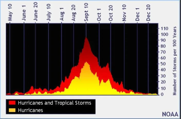
With the river’s two main reservoirs at all-time lows, the federal government is asking the seven states that use the Colorado to cut consumption next year by a staggering amount, up to one-third of the river’s normal annual flow. And beyond 2023, as climate change continues to take a toll on the river, painful long-term cuts in water use will be necessary.

All the reductions will have to be negotiated among states that, more often than not have been fiercely protective of their share of the river’s water. Those shares were originally negotiated during wetter times a century ago.

The states have negotiated some important agreements over the years, including one that prescribed cuts, based on water levels at Lake Mead on the lower Colorado, that were first implemented last year. But the demand for much larger reductions has put a spotlight on perennial tensions between the upper basin states of Colorado, Utah, New Mexico and Wyoming, who collectively use less than their allotted share, and the lower basin states of California, Nevada and Arizona, who use their full allotment or more.

The states missed a mid-August deadline to negotiate next year’s cuts. The federal government has effectively given them more time, but is threatening to step in and order the reductions.

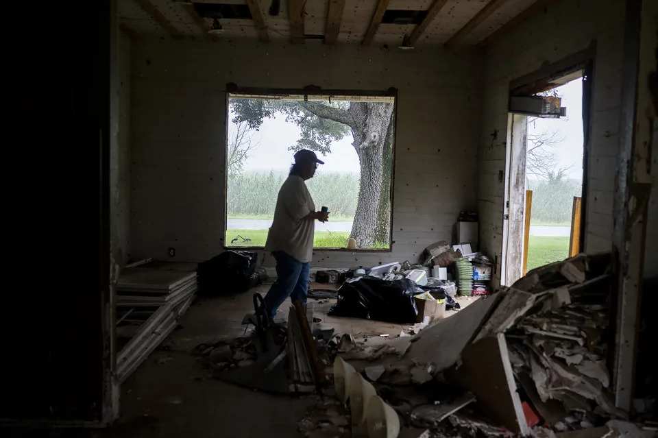
The Yakima Basin is far smaller than the Colorado, with a population of 350,000 compared with the 40 million people who rely, to varying degrees, on the Colorado’s supply. While farmland in the basin is important (among other things, it produces about 75% of the country’s hops that impart a tang to countless beers and ales), agricultural production along the Colorado is much larger.

The Yakima River, itself a tributary of the Columbia, is only 210 miles long, one-seventh the Colorado’s length, and lies within a single state, not seven plus Mexico. Thirty Native tribes have rights to Colorado water, compared with just the Yakama Nation.

All of that makes some water managers on the Colorado doubt that the Yakima plan could be much of a model.

“The Colorado River is orders of magnitude more complex and difficult than the Yakima,” said Jim Lochhead, CEO of Denver Water, which supplies drinking water to the city and surrounding communities. “That makes it extremely difficult to sit down a group of stakeholders and agree on a grand solution.”

But those who are intimately familiar with the Yakima plan say the plan’s fundamental principle, of shared sacrifice and cooperation among groups that were often adversaries, can apply anywhere.

“Everyone can’t get everything that they want,” said Thomas Tebb, director of the Columbia River office of the state Department of Ecology. “But if they can get something, that’s really the basis of the plan.”

The Yakima River has a long history of overuse, dating to the early white settlers who arrived after a treaty was signed between the federal government and the Yakama Nation in 1855. The river and its tributaries were dammed and diverted, and irrigation systems were built. Water shortages quickly became an issue, especially in dry years, leading to decades of conflicts among users.

As on the Colorado, there were earlier efforts to ensure a stable supply, especially following droughts in the 1930s and ’40s. After another severe drought, in 1977, state and federal officials developed a “watershed enhancement” plan to try to improve fish passage.

But it wasn’t enough. For one thing, the droughts kept coming, said Urban Eberhart, who grew up on a farm in the basin and now manages the Kittitas Reclamation District in the northern part.

“Instead of just being one of these droughts, we started getting them back-to-back and then three in a row,” he said.

In 2010, the federal Bureau of Reclamation undertook a study of the basin, looking at how it would fare as the world continued to warm. The findings added impetus to the drive to develop a plan.

“What we went through from 1977 to 2009 was nothing in comparison to where we were headed,” Eberhart said. There was a growing sense that drastic action was needed. “We won’t recognize this economy or this ecosystem if we don’t act.”

With so much information to discuss, the meetings on the plan were intense and time consuming, Eberhart said. But that had a benefit: Pressed for time, participants started taking breaks and lunches together.

“Pretty soon, over time, all of us who were very suspicious of each other would talk, and that turned into friendship, trust and respect,” he said.

Rigdon said that now, as likely as not, a project gets widespread support, even from groups that might not see as much benefit from it. Although challenges remain, he said, “We’ve understood what the other side needs. And they’re no longer the other side.”

The fruits of those relationships can be seen throughout the basin, in projects that usually serve more than one purpose and benefit more than one group of stakeholders.

In the Yakama Nation’s irrigation district, canal work and dam improvements are saving water and improving fish habitat.

In his irrigation district, Eberhart has led successful efforts to use the canals to deliver water to long-dried-up streams, to restore fish.

There are several projects, under construction and proposed, to increase water storage to help make it through dry years. And in the city of Yakima itself, Nelson Dam, an old diversion dam on a tributary has been removed, replaced by an engineered channel that will allow passage of both fish and boats, redistribute sediment through the river system and reduce flooding, all while continuing to divert water for the city’s needs.

“It’s not doing one thing — do things that meet everybody’s criteria,” said George Brown, the city’s assistant public works director. “If you do that, everybody agrees.”

On the Gulf Coast, a Quiet Hurricane Season (So Far!) Brings Little Relief

The New York Times

On the Gulf Coast, a Quiet Hurricane Season (So Far!) Brings Little Relief

Rick Rojas – September 5, 2022

Susie Fawvor in her family home, which has withstood every major hurricane since its construction in 1915, but was damaged in Hurricane Laura in 2020, in Grand Chenier, La., Sept. 3, 2022. (Emily Kask/The New York Times)

IOWA, La. — In a community still etched with the scars of past storms that charged in from the Gulf of Mexico, the congregants at St. Pius X begin each service this time of year by petitioning God with the same solemn appeal: Please, spare us.

“We live in the shadow of a danger over which we have no control,” they say, repeating the prayer at every Mass from the start of hurricane season in June through the end in November. “The Gulf, like a provoked and angry giant, can awaken from its seeming lethargy, overstep its conventional boundaries, invade our land, and spread chaos and disaster.”

But so far this year, there has been no invasion. Any chaos and disaster are the residuals of devastating hurricanes that pummeled this stretch of the Louisiana coast two years ago.

It has been a hurricane season without hurricanes. But the quiet, however appreciated, does not bring much comfort.

“Who knows what next week holds?” said the Rev. Jeffrey Starkovich, the pastor at St. Pius X, a Catholic parish in Ragley, Louisiana, an unincorporated community about 20 miles north of Lake Charles. “You can’t rest. You can’t be confident it’s going to stay quiet.”

Last month was the first August in 25 years without a named storm in the Atlantic Ocean. No hurricanes have made landfall this year in the United States. And though hurricane season spans six months, it is this time of year — from late August through October — when the season typically packs its most powerful punch.

A weather system named Danielle strengthened last week into a Category 1 storm, becoming the first hurricane of the season; it weakened briefly to a tropical storm before regaining hurricane status. Entering the week, Danielle cut a meandering path over the Atlantic and posed little threat to land.

In a part of the world where so many routines and rituals are shaped by the rhythms of hurricane season, the relative calm has done anything but inspire complacency. Instead, it has offered communities often in the path of hurricanes yet another vivid illustration of how capricious nature can be.

“We really don’t have any sighs of relief until hurricane season is completely over,” said Nic Hunter, the mayor of Lake Charles, a working class city in southwestern Louisiana still staggering its way back from a powerful pair of storms in 2020. “With all we’ve been through, I don’t think anyone wants to test fate.”

The very existence of this article and others like it is a source of considerable unease. Asked about hurricane season while she and a friend were outside working on a lawn mower last week, Ricki Lonidier pressed her finger to her lips and glared.

“Don’t speak it into existence!” her friend, Richelle Wiley, said.

But she knew their luck would last only so long. “We know it’s coming,” she said. “It’s inevitable.”

That evening, the humid air was thick with mosquitoes. She took it as a sign of brewing trouble.

Scientists still expect an “above normal” hurricane season this year, with 14 to 20 named storms in the Atlantic and up to 10 of those strengthening into hurricanes. Last year, there were 21 named storms. The year before that set a record with 30.

On the Gulf Coast, hurricanes are more than just weather events. Their names — Audrey, Katrina, Rita, Ike, Laura — become chronological reference points for marking history. Chain-link fences are often referred to as hurricane fences, and for several years, a newspaper on the Texas coast called its weekly entertainment guide “cat5,” for a Category 5 hurricane, because, well, why not?

Like clockwork, around June, hurricane-themed public service announcements start filling commercial breaks on TV and radio and appearing on highway signs. It is time to start stockpiling water, canned goods and batteries. It is time to use up the food in the freezer so you will not have to toss out too much when a storm surely will knock out power.

Then, the anxiety sets in.

“It’s kind of like the proverbial sword of Damocles — it hangs over your head,” said Bishop Glen John Provost of the Diocese of Lake Charles, who leads worshippers through a “Mass to Avert the Storms” every year at the beginning of hurricane season. “The apprehension grows from the unknown.”

But in recent years, along this slice of the Louisiana coast, the tumult and torment of a hurricane have become far less abstract. A changing climate has intensified the threat, and powerful storms are likely to become more frequent.

In 2020, Hurricane Laura made landfall in Cameron Parish, south of Lake Charles, as a Category 4 storm with 150 mph winds — one of the most powerful storms to strike Louisiana. Roughly six weeks later, Hurricane Delta hit, cutting a nearly identical path. “What wasn’t taken out by Laura was finished by Delta,” Curtis Prejean said last week as he sat on his back porch with his wife, Shirley.

In the communities in and around Lake Charles, the recovery had been long and uneven. Curtis Prejean has a brother who has been living in a camper for two years. Wiley’s home had been stripped down to its studs inside and the outside was still battered. She is in a constant fight to fend off black mold.

The next storm could take what little some have left.

“We were talking about the hurricanes yesterday,” Wiley said, “and reality is stopping me, because I have nowhere to go. I’m about to be homeless.”

During one recent storm, the Prejeans put down a mattress pad in the hallway of the modest home where they have lived for 33 years and rode it out with two dogs and a cat. The house vibrated, and the noise was terrifying. “I told my husband we’re never doing that again,” Shirley Prejean said.

“I’m going to stay for a Cat. 1,” Curtis Prejean said. “A Cat. 2 …” He shrugged. That’s where he was unsure.

No matter the category, Curtis Goodwin — or as everyone knows him, Warrior War Dog — vowed to stay put. Blue tarps covered parts of his roof, and his exterior walls were still damaged. But he had fortified part of his house with the expectation that his family and dogs would pile inside.

“I’m going to stay right here, and I’m going to ride it out,” he said.

He knew what his cousin and her family had gone through when they left town in anticipation of Hurricane Laura. A few frightening hours at home were better than the weeks of frustration and turbulence that come with evacuating, he reasoned.

Katina Jackson, his cousin, was gone for several months. First, she fled her home in Lake Charles for San Antonio. On the way, the axle on her car broke. If it were not for a mechanic giving her a deal, her family would have been stranded. They stayed in hotels in San Antonio and Fort Worth, Texas, before going home.

The return of hurricane season dredged up all of that.

“It’s just going to be catastrophic again,” Jackson said outside her cousin’s house, helping her daughter take out her braids on a hot but otherwise pleasant evening. “I feel like it’s always quiet before the storm.”

A few minutes later, ominous clouds that had been lurking in the distance swarmed the neighborhood in darkness, and a surge of lightning ripped through the sky.

UPDATE: Mill Fire explodes to 3,921 acres with no containment, Mountain Fire at 600 acres

Redding Record Searchlight

UPDATE: Mill Fire explodes to 3,921 acres with no containment, Mountain Fire at 600 acres

David Benda, Michele Chandler, Jessica Skropanic and Jenny Espino, Redding Record Searchlight

September 3, 2022

The fast-moving Mill Fire erupted on Friday near the area of the Roseburg Forest Products mill in Weed, a small city just over 50 miles from the Oregon border. 

There were reports of burn victims and destroyed homes in a neighborhood. Thousands were forced to leave their homes in the communities of Weed, Lake Shastina and Edgewood.

We’ve made these updates free to readers as an important public service to our North State communities. If you are able, help local journalism thrive by subscribing to your local newspaper, and check back here for updates.

10:20 p.m.: Mill Fire still growing, with no containment

Cal Fire on Friday night said sensor aircraft estimated the size of the Mill Fire to be 3,921 acres, roughly 1,300 acres more than fire officials believed earlier in the evening.

The fire, first reported at 12:49 p.m. on Friday, broke out at Woodridge Court and Woodridge Way, near the area of the Roseburg Forest Products mill in Weed. The Cal Fire-Siskiyou Unit via Twitter said the cause of the fire is under investigation.

Evacuations in Weed, Lake Shastina and Edgewood remain in place and Highway 97 remains closed.

8:40 p.m.: Mountain Fire doubles in size, Mill Fire unstable, Sheriff’s Office said

The Mountain Fire grew to 600 acres, twice its size two hours ago, according to Cal Fire.

Both the Mill Fire and Mountain Fire remain uncontained, according to Cal Fire.

“This incident (Mill Fire) is rapidly changing and our staff and partners are doing everything they can to get everyone to safety,” the Siskiyou County Sheriff’s Office said.

The sheriff’s office posted information to help those unable to reach family and friends in evacuation areas. They can call 530-842-8746.

An evacuation shelter is in use at the Yreka Community Center at 810 North Main St. in Yreka.

For information on evacuation zones go to www.zonehaven.com.

8:15 p.m.: Help available for animals in fire evacuation zones

The Siskiyou County Sheriff’s Office is offering animal welfare checks for people who had to evacuate from Mill and Mountain fire areas without their pets or livestock.

Evacuees can go to the Siskiyou County website at bit.ly/3Qc9Hsf and fill out a form to request a welfare check.

6:50 p.m.: Mill Fire explodes Friday afternoon

The Mill Fire exploded in size to 2,580 acres — up from 900 acres at 3 p.m., according to Cal Fire.

There is no containment on the fire, burning north of Weed near Lake Shastina.

The blaze damaged and destroyed multiple structures, including homes, but Cal Fire has not yet released the total number of structures.

The cause of the fire remains under investigation, Cal Fire said.

6:30 p.m.: Mountain Fire grows to 300 acres

The Mountain Fire burned 300 acres of forest eight miles southeast of the small town of Gazelle, according to Cal Fire.

It is not contained, Cal Fire said.

The fire started before 4 p.m. near China Mountain Road, west of Interstate 5, north of Weed.

5:30 p.m.: Some tankers being sent to nearby Mountain Fire

While firefighters continue to battle the Mill Fire burning in the area of Weed and Lake Shastina, six air tankers are being diverted to a second fire that started about an hour ago in the area of Gazelle.

The Mountain Fire is burning in heavy brush on the west side of Interstate 5 north of Weed. Firefighters there have reported that no structures are threatened.

5 p.m.: Wind pushing fire over dry hot terrain

Firefighters continue to battle strong winds while they fight the Mill and Mountain fires.

Those conditions won’t change until Friday night, said Jay Stockton, meteorologist with the National Weather Service in Medford. Weather conditions are ripe for fires to continue spreading until 11 p.m.

Friday afternoon, strong southeast winds blew up to 24 mph, with 36 mph gusts, Stockton said. Temperatures reached 98 degrees in Weed and brush is incredibly dry: 5% humidity.

“That combination of windy and dry is what’s creates conditions for rapid fire growth,” he said.

A red flag warning is in effect until 11 p.m. Friday, at which time the winds should calm down, Stockton said. Temperatures should cool to the mid-50s, increasing moisture in the air.

All that could help firefighters get a better handle on the fires, he said.

4:14 p.m.: Power outage reported in Weed, Mount Shasta, Lucerne

About 8,300 residents in Weed and Mount Shasta in Siskiyou County and Lucerne in Lake County were hit by a power outage shortly before 1 p.m. on Friday, according to electric power company PacifiCorp.

A cause of the outage is under investigation, said company spokesman Brandon Zero. Crews have been dispatched to the area, he said.

A smoke plume from the Mill Fire rises over downtown Weed on Friday, Sept. 2, 2022.
3:55 p.m.: Fire threatening Carrick outside Weed

Firefighters are communicating to each that the fire is threatening to jump Highway 97 and burn into the small community of Carrick just outside Weed.

3:20 p.m.: Mill Fire balloons to 900 acres

The Mill Fire burning north of Weed toward Lake Shastina is now more than 900 acres, Cal Fire reports.

Firefighters are asking for all strike teams to come to the Jackson Ranch Road area. Earlier, the fire jumped Jackson Ranch Road and started burning into Lake Shastina.

Currently, there is no containment.

All zones east of Interstate 5 from Weed to county road A12, south of county road A12 from Grenada to Highway 97, west of Highway 97 from A12 to I-5, Cal Fire said.

There is an evacuation Shelter at the Karuk wellness center in Yreka at 1403 Kahtishraam.

Meanwhile, all remaining Weed High School students were bussed to Mt. Shasta High School for pick up, officials said.

2:50 p.m.: Fire burning into Lake Shastina

The Mill Fire has jumped Jackson Ranch Road and is burning into the community of Lake Shastina, which is north of Weed, crews battling the blaze report. Firefighters also have asked for at least five more strike teams to help fight the fire.

Meanwhile, a temporary evacuation center is being set up at the Siskiyou County Fairgrounds in Yreka, according to scanner reports.

2:45 p.m.: Mill Fire grows to 555 acres

The communities of Weed, Lake Shastina and Edgewood are under evacuation orders as of 2 p.m. Friday due to the Mill Fire, according to the Siskiyou County Sheriff Office’s Facebook page.

Residents in those areas are asked to leave immediately.

Use caution, as emergency vehicles are assisting with evacuations, structure protection and fire suppression efforts. For more information, call 2 1 1. Real-time evacuation zone statuses are available on aware.zonehaven.com.

The Mill Fire near Weed has grown to 555 acres since first being reported on Friday afternoon, officials said.

The wildfire broke out the same day that the area was under a red flag warning due to high temperatures, gusty winds and low humidity. The chance of rain in the area remains in the single digits through Tuesday.

The wind was blowing north at 20 mph in the Weed and Lake Shastina areas on Friday afternoon, according to Windfinder.com.

Southerly winds of about 20 mph, with gusts as high as 30 mph, could emerge through Friday night, according to the National Weather Service.

The Mill Fire as seen from Interstate 5. The fire started on Friday afternoon, Sept. 2, 2022.

Saturday’s forecast calls for sun with widespread haze and a high near 89. Calmer winds becoming northwest at between 5 to 8 mph are expected in the afternoon, according to the weather service.

Pacific Power had not reported any outages in greater Weed as of mid-afternoon on Friday.

1:55 p.m.: Students to stay on campus

Firefighters battling the Mill Fire are recommending not to release students at Weed High School. They are asking the students to stay on campus for now, according to scanner reports.

Meanwhile, mandatory evacuations are being called for all residents east of Interstate 5 to Jackson Ranch Road. Firefighters say the blaze has reached Jackson Ranch Road.

Also, all of Lake Shastina is under a mandatory evacuation order.

Evacuation warnings are in place along Highway 97 in the Mt. Shasta Vista neighborhood.

1:49 p.m.: Evacuations ordered

Evacuation orders have been issued in the community of Weed due to a fire that started Friday afternoon in the area of Roseburg Forest Products mill.

Highway 97 is closed from the junction of Highway 265 in Weed to south of Macdoel due the Mill Fire, the California Department of Transportation said.

Firefighters are also asking for Jackson Ranch Road to be closed so residents who are evacuating in that area have a clear route out of the neighborhood, according to emergency scanner reports.

The fire also has reached Hoy Road.

Firefighters report that traffic in the area is backed up due to all the evacuations.

At least one ambulance has been dispatched to treat a burn victim and a medical triage has been set up to treat other burn victims, scanner reports said.

Thousands flee, several hurt as Mill Fire scorches Weed, Lake Shastina in Northern California

Redding Record Searchlight

Thousands flee, several hurt as Mill Fire scorches Weed, Lake Shastina in Northern California

Adam Beam – September 3, 2022

Thousands of people remained under evacuation orders Saturday after a wind-whipped wildfire raged through rural Northern California, injuring people and torching an unknown number of homes.

The fire that began Friday afternoon on or near a wood-products plant quickly blew into a neighborhood on the northern edge of Weed but then carried the flames away from the city of about 2,600.

Evacuees described heavy smoke and chunks of ash raining down.

Annie Peterson said she was sitting on the porch of her home near Roseburg Forest Products, which manufactures wood veneers, when “all of a sudden we heard a big boom and all that smoke was just rolling over toward us.”

Very quickly her home and about a dozen others were on fire. She said members of her church helped evacuate her and her son, who is immobile. She said the scene of smoke and flames looked like “the world was coming to an end.”

A house in the Lake Shastina Subdivision, northwest of Weed, burns up on Friday, Sept. 2, 2022. The Mill Fire erupted that afternoon in the area of the Roseburg Forest Products mill in Weed and raced out of control, forcing residents in that Northern California community, Lake Shastina and Edgewood to flee their homes.

Suzi Brady, a Cal Fire spokeswoman, said several people were injured.

Allison Hendrickson, spokeswoman for Dignity Health North State hospitals, said two people were brought to Mercy Medical Center Mount Shasta. One was in stable condition and the other was transferred to UC Davis Medical Center, which has a burn unit.

Catch up: Mill Fire explodes to 3,921 acres with no containment, Mountain Fire at 600 acres

Rebecca Taylor, communications director for Roseburg Forest Products based in Springfield, Oregon, said it is unclear if the fire started near or on company property. A large empty building at the edge of company property burned she said. All employees were evacuated, and none have reported injuries, she said.

The blaze, dubbed the Mill Fire, was pushed by 35-mph winds, and quickly engulfed 4 square miles of ground.

The flames raced through tinder-dry grass, brush and timber. About 7,500 people in Weed and several nearby communities were under evacuation orders.

Dr. Deborah Higer, medical director at the Shasta View Nursing Center, said all 23 patients at the facility were evacuated, with 20 going to local hospitals and three staying at her own home, where hospital beds were set up.

Gov. Gavin Newsom declared a state of emergency for Siskyou County and said a federal grant had been received “to help ensure the availability of vital resources to suppress the fire.”

Cal Fire firefighters try to stop flames from the Mill Fire from spreading on a property in the Lake Shastina Subdivision northwest of Weed on Friday, Sept. 2, 2022. The Mill Fire erupted that afternoon in the area of the Roseburg Forest Products mill in Weed and raced out of control, forcing residents in that Northern California community, Lake Shastina and Edgewood to flee their homes.

At about the time the blaze started, power outages were reported that affected some 9,000 customers, and several thousand remained without electricity late into the night, according to an outage website for power company PacifiCorp, which said they were due to the wildfire.

It was the third large wildfire in as many days in California, which has been in the grip of a prolonged drought and is now sweltering under a heat wave that was expected to push temperatures past the 100-degree mark in many areas through Labor Day.

Thousands also were ordered to flee on Wednesday from a fire in Castaic north of Los Angeles and a blaze in eastern San Diego County near the Mexican border, where two people were severely burned and several homes were destroyed. Those blazes were 56% and 65% contained, respectively, and all evacuations had been lifted.

The heat taxed the state’s power grid as people tried to stay cool. For a fourth day, residents were asked to conserve power Saturday during late afternoon and evening hours.

The Mill Fire was burning about an hour’s drive from the Oregon state line. A few miles north of the blaze, a second fire erupted Friday near the community of Gazelle. The Mountain Fire has burned more than 2 square miles but no injuries or building damage was reported.

The whole region has faced repeated devastating wildfires in recent years. The Mill Fire was only about 30 miles southeast of where the McKinney Fire — the state’s deadliest of the year — erupted in late July. It killed four people and destroyed dozens of homes.

Olga Hood fled her Weed home on Friday as smoke was blowing over the next hill.

With the notorious gusts that tear through the town at the base of Mount Shasta, she didn’t wait for an evacuation order. She packed up her documents, medication and little else, said her granddaughter, Cynthia Jones.

“With the wind in Weed everything like that moves quickly. It’s bad,” her granddaughter, Cynthia Jones, said by phone from her home in Medford, Oregon. “It’s not uncommon to have 50 to 60 mph gusts on a normal day. I got blown into a creek as a kid.”

Hood’s home of nearly three decades was spared from a blaze last year and from the devastating Boles Fire that tore through town eight years ago, destroying more than 160 buildings, mostly homes.

Hood wept as she discussed the fire from a relative’s house in the hamlet of Granada, Jones said. She wasn’t able to gather photos that had been important to her late husband.

Scientists say climate change has made the West warmer and drier over the last three decades and will continue to make weather more extreme and wildfires more frequent and destructive. In the last five years, California has experienced the largest and most destructive fires in state history.

Associated Press reporters Olga R. Rodriguez and Janie Har in San Francisco and Stefanie Dazio and Brian Melley in Los Angeles contributed to this article.

Hurricane Danielle becomes first hurricane of 2022 Atlantic season. Category 2 storm in forecast

Palm Beach Daily News

Hurricane Danielle becomes first hurricane of 2022 Atlantic season. Category 2 storm in forecast

Cheryl McCloud, Palm Beach Post – September 2, 2022

Hurricane Danielle has become the first hurricane of the 2022 Atlantic season.

Maximum sustained winds have increased to 75 mph, according to the National Hurricane Center.

Danielle is forecast to continue strengthening, with winds expected to hit 100 mph over the next 48 hours, making it a Category 2 storm.

There is no threat to the U.S. from the storm.

► Your guide to preparing for the 2022 hurricane season in Florida

 Track all active storms

 Excessive rainfall forecast

Danielle’s path will be an untraditional one, with the hurricane forecast to trace a small loop over the waters of the North Atlantic through the weekend, according to AccuWeather.

Spaghetti models for Hurricane Danielle as of 11 a.m. Sept. 2, 2022.

The Hurricane Center also is monitoring two other tropical waves in the Atlantic, Invest 91L and Invest 94L.

Chances have dropped overnight for the development of 91L, the closest disturbance to the U.S.

What’s happening in tropics: August hasn’t been this devoid of tropical storms since 1997. Is hurricane season over?

WeatherTiger: Baffling scot-free hurricane season thus far, but stormless streak ends with Danielle

The next named storm of the season will be Earl.

Here’s the latest update from the NHC as of 11 a.m. Sept. 2:

  • Location: 885 miles west of the Azores; 2,238 east of Daytona Beach
  • Maximum wind speed: 75 mph
  • Direction:  west at 1 mph

Maximum sustained winds have increased to near 75 mph, with higher gusts.

Some additional strengthening is forecast during the next couple of days. Winds are expected to reach 100 mph within 48 hours.

Hurricane-force winds extend outward up to 15 miles from the center and tropical-storm-force winds extend outward up to 115 miles.

What else is out there and where are they?
Hurricane Danielle becomes the first hurricane of the 2022 Atlantic hurricane season.

Invest 91L: Shower and thunderstorm activity has slightly increased since yesterday in association with an area of low pressure located several hundred miles east of the Leeward Islands.

Invest 94L: Shower activity associated with a broad area of low pressure located northwest of the Cabo Verde Islands has slightly increased since yesterday.

How likely are they to strengthen?
Tropical conditions 5 a.m. Sept. 2, 2022.

Invest 91L: Overnight satellite-derived wind data indicate the circulation remains broad. Although environmental conditions are only marginally conducive, any additional development of the system over the next few days would lead to the formation of a tropical depression.

The disturbance is expected to move slowly west-northwest, toward the adjacent waters of the northern Leeward Islands.

An Air Force Reserve Hurricane Hunter aircraft is scheduled to investigate the system this afternoon, if necessary.

  • Formation chance through 48 hours: medium, 50 percent.
  • Formation chance through 5 days: medium, 70 percent.

Invest 94L: This system is moving into an area of less favorable environmental conditions, and significant development is not expected.

  • Formation chance through 48 hours: low, 10 percent.
  • Formation chance through 5 days: low, 10 percent.
Who is likely to be impacted?

Invest 91L: Regardless of development, locally heavy rains may occur over portions of the Leeward Islands during the next couple of days, and residents in that area should monitor the progress of the system.

Invest 94L: It’s too early at this time to determine if there will be any impact to the U.S. from Invest 94L.

Forecasters urge all residents to continue monitoring the tropics and to always be prepared during what’s expected to be an active hurricane season.

Colorado State University’s two-week hurricane forecast for Sept. 1-14 calls for a 70% chance of near-normal activity, a 25% chance of above-normal activity and a 5% chance of below-normal activity.

When is the Atlantic hurricane season?

The Atlantic hurricane season runs from June 1 through Nov. 30.

When is the peak of hurricane season?
Hurricane season's ultimate peak is Sept. 10 but the season goes through Nov. 30. Credit: NOAA
Hurricane season’s ultimate peak is Sept. 10 but the season goes through Nov. 30. Credit: NOAA

Although the season has gotten off to a quiet start, the peak of the season is Sept. 10, with the most activity happening between mid-August and mid-October, according to the Hurricane Center.

Weather watches and warnings issued for your area

If you can’t see any local weather warnings here, you’ll need to open this story in a web browser.

The next five days

See the National Hurricane Center’s five-day graphical tropical weather outlook below.

Excessive rainfall forecast
What’s out there?

Systems currently being monitored by the National Hurricane Center.

Dirty water, drying wells: Central Californians shoulder drought’s inequities

Los Angeles Times

Dirty water, drying wells: Central Californians shoulder drought’s inequities

Hayley Smith – September 2, 2022

VISALIA, CA - August 16, 2022 - A gage shows only a few pounds of pressure in the well at Jesus Benitez's home in Visalia on Tuesday, Aug. 16, 2022 in VIsalia, CA. (Brian van der Brug / Los Angeles Times)
A gauge shows only a few pounds of pressure in the well at Jesús Benítez’s home near Visalia. (Brian van der Brug / Los Angeles Times)

On a hot morning in August, the pressure gauge on Jesús Benítez’s well read about 10 pounds per square inch — barely enough for a trickle.

The 74-year-old has been living just outside of Visalia, in the heart of California’s San Joaquin Valley, for about 14 years, ever since he decamped from Downey in search of bigger skies and more space. But the once-green three-acre property that was meant to be his retirement haven is now dry, brittle and brown.

Like a growing number of Central Californians, Benítez is bearing the brunt of the state’s punishing drought, which is evaporating the state’s surface water even as a frenzy of well drilling saps precious reserves underground. As a result, the number of dry wells in California has increased 70% since last year, while the number of Californians living with contaminated drinking water is at nearly 1 million.- ADVERTISEMENT -https://s.yimg.com/rq/darla/4-10-1/html/r-sf-flx.html

The majority of those people live in low-income communities and communities of color, state data show — and experts say heat, drought and climate change are only making those inequities worse.

“We’re fighting an uphill battle due to climate change,” said Gregory Pierce, director of the Human Right to Water Solutions Lab at UCLA. “Even with the progress we’re making, there are other losses that few people anticipated when it comes to heat impacts on water quality … and the pace at which people, and even larger systems, are at risk of running out of water entirely.”

Jesús Benítez stands near a spot where an underground pipe carrying city water ends just 100 feet from his home
Jesús Benítez, who has little water, stands near a spot where an underground pipe carrying city water ends just 100 feet from his home outside Visalia. (Brian van der Brug / Los Angeles Times)

Benítez is one of the unlucky people dealing with both. His sputtering well — the only source of water on his property — is polluted with nitrates, uranium and hexavalent chromium, which are becoming more concentrated as the water draws down. He and about 60 other residents in the area are trying to get connected to the water system that services the city of Visalia, but officials have told them the work may not be complete until 2024.

“I hope I don’t die without water by then,” Benítez said. The nearest municipal pipeline ends just about 100 feet from his property.

His story is becoming increasingly common in California, where an audit last month found that the State Water Resources Control Board “lacks the urgency necessary to ensure that failing water systems receive needed assistance in a timely manner.” The audit also noted that more than two-thirds of the water systems that have fallen below basic quality standards are in disadvantaged communities of significant financial need.

“California is one of the largest economies in the world, and yet this is happening here,” said Pedro Calderón Michel, a spokesman with the nonprofit group the Community Water Center. All too often, he said, “the browner your skin, the browner your water will be.”

Jesús Benítez's home, top center, sits on a dry dusty lot where he has little water
Jesús Benítez’s home, top center, sits on a dry dusty lot where he has little water. A neighboring farm growing silage corn, bottom, is green. (Brian van der Brug / Los Angeles Times)

The problem is multifaceted. On the surface, climate change-fueled heat and dryness are contributing to a thirstier atmosphere that is sapping the state’s water, while a persistent lack of rain and snowpack means mounting deficits are not getting replenished. More than 97% of the the state is under severe, extreme or exceptional drought, and officials have said the first half of the year was the driest it’s ever been.

But much of the problem is happening underground, where California’s aquifers have long served as a reliable source of water, especially during dry times. In 2014, the state passed the Sustainable Groundwater Management Act, a historic law intended to address the overpumping of those supplies. But the act laid out a timeline that spans more than two decades, and set off a rash of well drilling among those trying to beat the deadline, particularly in agricultural areas where wells are the lifeblood of the industry.

Residents who rely on domestic wells are increasingly paying the price. Benítez’s well, for example, dried up after a neighbor installed a new, deeper well to help water 25 acres of silage corn, or corn used to feed dairy cows and other livestock.

That neighbor, Frank Ferreira, said he spent $160,000 on the well, and he may need to dole out even more to dig deeper when it dries up. When asked whether the state has placed any limits on how deep he can go, Ferreira said, “not yet.”

Frank Ferreira pulls a handful of fresh water from a large open pipe at his farm near Visalia.
Frank Ferreira pulls a handful of fresh water from a large open pipe at his farm near Visalia. Ferriera says the water from his well is delicious. (Brian van der Brug / Los Angeles Times)

While agriculture is a leading factor in groundwater depletion and contamination, the added layer of drought is exacerbating the problem, according to Joaquin Esquivel, chair of the State Water Resources Control Board.

“As you draw down your aquifers, you get left with more and more of the undesirable constituents,” he said. “In water quality control, it’s often said, ‘The solution to pollution is dilution.’ When you have the opposite — very little amounts coming in, little recharge happening with fresher flows — you get an increase in contaminants.”

Esquivel acknowledged that some conclusions from the state audit were fair, including some findings around delayed response times for funding and other assistance for drinking water systems. Systems can receive funds to help with the design and construction of new infrastructure, the maintenance of existing infrastructure or other projects that address or prevent public health risks. Over the past five years, the average length of time for water systems to complete applications and receive funding from the board nearly doubled from 17 to 33 months, the audit said.

An equestrian rides along Jesús Benítez's driveway.
An equestrian rides along Jesús Benítez’s driveway. (Brian van der Brug / Los Angeles Times)

But he also called the top-line conclusion that the board lacks urgency “bombastic” and inaccurate. Since 2019, the board has reduced the number of Californians served by failing systems by 40%, from 1.6 million to 950,000, he said. It also doubled the amount of community construction grants to $700 million and increased technical assistance funding for small disadvantaged communities by 150%.

“I think what we have is a really good down payment and a good start,” he said. “What’s helpful here is we need to continue to really be clear about how long it takes to get projects done.”

Critically, Esquivel also noted that many of the challenges the state is facing when it comes to clean, safe and affordable drinking water are the result of generations of racist policies.

“There’s a complicated context to all of this,” he said. “That’s not the excuse for why it takes the time it takes, but I think I do have to mention here that there were explicit redlining policies that purposely didn’t extend service to our communities.”

Redlining was the institutional practice of denying homeownership and financial services to residents based on race.

One Central Valley community that still feels the weight of those policies is Tooleville, which is home to about 200 residents, nearly half of whom are Latino, according to the latest U.S. Census.

In 1973, Tooleville was one of 15 communities that the Tulare County general plan deemed as having “little or no authentic future,” and for which public commitments should be “carefully examined,” one study noted.

“These non-viable communities would, as a consequence of withholding major public facilities such as sewer and water systems, enter a process of long term, natural decline as residents depart for improved opportunities in nearby communities,” the plan documents read.

But that’s not what happened. Instead, residents there have for decades depended on two wells that have become increasingly contaminated with nitrates, arsenic, hexavalent chromium, 123 trichloropropane and other pollutants. Sometimes, they sputter to a stop.

Susana de Anda, director of the Community Water Center in Visalia, gestures while talking.
“Water flows toward money and power,” says Susana de Anda, director of the Community Water Center in Visalia. (Brian van der Brug / Los Angeles Times)

“If you’re low income and a person of color and you live in the Central Valley, you’re going to have higher chances of having to pay for toxic water and a very expensive water bill for water that can get you sick,” said Susana De Anda, co-founder and executive director of the Community Water Center.

“It’s no surprise you go into our communities and you don’t see a thriving community, because water limits growth,” she said. “The most basic thing is, without safe drinking water, it blocks all economic development.”

The Community Water Center has spent the last 16 years working with residents on the ground in communities like Tooleville and fighting for legislation such as California’s Human Right to Water Act and the Sustainable Groundwater Management Act. They also helped achieve a moratorium on unpaid water bills during the first year of the COVID-19 pandemic, De Anda said.

But while there have been many victories, the drought has created a new layer of difficulty, she said, and more than 90% of San Joaquin Valley residents are now relying solely on groundwater.

“Unfortunately the drought only worsens the already dire conditions that our community is faced with — which is they don’t have safe drinking water,” De Anda said. “That’s constant stress. Now on top of that, some are losing water. So you add the layer, again, on top of this disproportionate impact when it comes to water quality.”

Jesús Benítez looks at his dropping water pressure at his home near Visalia.
Jesús Benítez looks at his dropping water pressure at his home near Visalia. (Brian van der Brug / Los Angeles Times)

In March, Gov. Gavin Newsom issued a drought order intended to slow the drilling of new wells. The order prohibits local governments from granting well-drilling permits if the proposed well is inconsistent with an area’s groundwater management plan. A piece of legislation, AB 2201, would have made that permanent, requiring groundwater sustainability agencies to weigh in on all well permit applications, but the bill didn’t come up for a final vote and died in the Legislature.

De Anda said it’s an important step in securing clean, safe water for everyone. But she also noted that all too often, “water flows toward money and power.”

“We’re talking about millions of families in California that don’t have safe drinking water and domestic wells,” she said. “The narrative should be, how do we help prioritize these communities to have a resilient community? How do we make sure that they’re part of water planning? How do we make sure that they’re at the top of the list with resources?  That’s what we should be thinking about.”

Maria Olivera, who is living with chromium and arsenic in her well, washes dishes at home.
Maria Olivera, who is living with chromium and arsenic in her well and is showering with contaminated water, washes dishes at home in Tooleville. Her family drinks and cooks with bottled water supplied by the state. (Brian van der Brug / Los Angeles Times)

Pierce, of UCLA, shared a similar sentiment.

“The impact of not having sufficient water is not just that you have to spend a bunch of money and get very little water, or you can’t use water for X, Y and Z purposes,” he said. “It’s a mental health and stress impact far beyond that, and a ‘dignity as a resident of the state’ impact. It’s hard to overstate that.”

Maria Olivera, who has lived in Tooleville since 1974, today relies on bottled water that she receives in jugs from the state — 60 gallons every two weeks — which she uses primarily for cooking and drinking. But she still has to shower in contaminated water, and she has to remind her visitors not to drink it.

“It’s hard, the way we live,” said Olivera, 68. “You always have to carry the gallons.”

Recently, the state ordered the neighboring community of Exeter to connect Tooleville to its water system after more than 20 years of refusing to do so. But the project could take two years to complete, Olivera said, and until then, she’ll keep relying on the plastic gallons.

Despite the challenges, Olivera shook her head when asked about the prospect of leaving. Tooleville has been her home for nearly 50 years.

“This is it for me. Where else am I going to go?” she said. “It’s a really nice community — we just need water.”

Death Valley keeps breaking records, but is it really the hottest place on Earth?

Los Angeles Times

Death Valley keeps breaking records, but is it really the hottest place on Earth?

Nathan Solis – September 2, 2022

Blue mountains against the sky with sand dunes in foreground
A view of Mesquite Dunes inside Death Valley National Park, where the temperature hit 127 degrees on Thursday at Furnace Creek. (Brian van der Brug / Los Angeles Times)

California’s Death Valley is one of the hottest places on Earth.

But was it in fact the hottest place on the planet Thursday when the giant thermometer at Furnace Creek in Death Valley National Park hit an eye-popping 127 degrees?

Officials caution that this is not an entirely accurate reading.

“The thermometer reading is taken literally from that site. It’s on the back of the digital display and it’s not even sheltered properly,” said Daniel Berc, a meteorologist with the National Weather Service in Las Vegas. “It’s more of a ‘Boy, wow! Look at this number.’ It’s not exactly what happened here.”

It’s a bit of an exaggeration when news stories point to the digital thermometer and claim Death Valley is the hottest place on Earth, Berc said. Meteorologists are usually not comfortable claiming one place is the hottest on the planet because that involves lots of data and research to confirm.

“But this is a hot one, I’ll give you that,” Berc admitted.

The official reading on Thursday for Death Valley was 124, beating the record set in 1996 by one degree. Forecasts show that Friday and Saturday could also break records set in the last 20 years by one degree. Friday’s standing record was set at 122 in 2017 and Saturday’s record was set at 121 in 2007, according to the National Weather Service.

But there’s always the possibility that the temperatures could fall just above or below whatever record was set that day, Berc said.

This latest heat wave is a late one for the season, landing at the tail end of the monsoon season. Earlier this month, Death Valley and the surrounding Mojave landscape were submerged in water as record rainfall gave way to flash floods. Flash floods hit the Las Vegas Strip at the end of July and returned in early August.

A heat wave butting in during the monsoon season is not unheard of, according to meteorologists. But a late heat wave is notable, with record temperatures reaching 8 to 10 degrees above normal, Berc said.

“People in Las Vegas don’t bat an eye at 100 degrees. But they take notice at 110 after Labor Day,” Berc said. “This one is a longer-lasting heat wave, which brings accumulative effects of not cooling down at night and particularly harming the homeless population.”

With less time to cool down, people don’t have the luxury of recuperating at night and might not notice they’re being negatively affected by the hotter weather.

This can be dangerous, even life-threatening.

“Heat is the No. 1 weather killer,” Berc said, “because people know not to go outside and stand in front of a tornado. Sometimes they don’t know better with the heat.”

As dangerous heat wave scorches California, Death Valley could hit a whopping 125 degrees

USA Today

As dangerous heat wave scorches California, Death Valley could hit a whopping 125 degrees

Doyle Rice, USA TODAY – September 2, 2022

A dangerous and sweltering heat wave will continue to consume much of the western U.S., especially California on Friday through the Labor Day weekend, the National Weather Service said.

The intense heat is exacerbating wildfire concerns and putting a strain on the electrical grid.

Temperatures in the mid- to upper 90s and lower 100s will result in widespread daily records each day for much of the region, the Weather Service said.

Notorious hot spot Death Valley could soar as high as 125 degrees on Saturday, AccuWeather said, which would come close to the hottest September temperature ever recorded on Earth of 126 degrees. The hellish location already holds the record for the world’s hottest temperature of 134 degrees, set in 1913.

Other temperature records likely to be broken

Elsewhere, many monthly temperature records are likely to be broken in inland areas of California, according to UCLA climate scientist Daniel Swain.

Nearly 50 million people from Arizona to Idaho were under excessive heat warnings and watches along with heat advisories, which probably will continue for the next several days. That includes major metropolitan areas such as Los Angeles, Sacramento and San Diego.

“Little to no relief from the heat overnight will only increase the heat stress and create a potentially dangerous situation for sensitive individuals,” the Weather Service warned.

HIGH HEAT: What is the hottest temperature ever recorded? Where on Earth was it?

Stephanie Williams, 60, cools off with water from a hydrant in the Skid Row area of Los Angeles, Wednesday. Excessive-heat warnings expanded to all of Southern California and northward into the Central Valley on Wednesday, and were predicted to spread into Northern California later in the week.

“This heat may produce a very high risk of heat illness,” the Weather Service in Los Angeles said.

The Capital Weather Gang said, “Close to 38 million people, the vast majority of them in California and Arizona, are predicted to experience highs hitting the century mark in the coming week.”

IS FALL REALLY HERE?: Today is the first day of fall, meteorologists say. But it won’t feel like it in the West.

AccuWeather chief meteorologist Jonathan Porter said: “The risks associated with this heat wave are even more concerning than other heat waves because this will be happening through the Labor Day weekend, a holiday weekend when many people are spending additional time outdoors and may be less aware of the heat risks.

“The heat wave will be notable due to its persistence – day after day of extreme heat with temperatures, in some locations such as California’s capital of Sacramento, near or exceeding 110 degrees for three or more days in a row,” Porter said.

“Extreme caution” is advised for people who go outdoors, the Weather Service in Sacramento said.

Wildfire, power concerns

Wildfires and power outages were high on the list of concerns among California officials on Friday.

In California, wildfires chewed through rural areas north of Los Angeles and east of San Diego, racing through bone-dry brush and prompting evacuations.

POWER PROBLEMS?: California hopes to avoid blackouts amid heat wave by asking millions of people to use less electricity

In northwestern Los Angeles County, the intense Route Fire near Castaic raged through more than 8 square miles of hills containing scattered houses late Wednesday. Traffic was snarled on Interstate 5, a major north-south route running through the fire area. Containment was estimated at 12% Thursday morning.

One structure had been destroyed and 550 remained threatened, the Los Angeles Times said, adding that “no civilian casualties were reported, but seven firefighters were injured.”

State officials hope to avoid rolling blackouts by asking residents to voluntarily use less power, even as the heat tempts Californians to crank up their air conditioners.

“One of the big unknowns in this (whether blackouts will happen) is that we also expect wildfires,” said Daniel Kammen, an energy professor at the University of California, Berkeley: “And wildfires will cause us to have to shut down certain transmission lines, de-energizing them to prevent wildfires.

“Then we could get into a situation where those rolling brownouts, we call them, when they’re scheduled, we tell people in advance. But right now, none of them are anticipated,” Kammen told USA TODAY.

CLIMATE CONNECTION: Extreme heat waves may be our new normal, thanks to climate change. Is the globe prepared?

Contributing: Celina Tebor, USA TODAY; the Associated Press

Death Valley sets record for hottest Sept. day — and California’s heat wave isn’t over

Yahoo! News

Death Valley sets record for hottest Sept. day — and California’s heat wave isn’t over

David Knowles, Senior Editor – September 2, 2022

Death Valley, Calif., set a record Thursday for the highest recorded temperature for the month of September, hitting 127 degrees Fahrenheit.

The new record comes as California bakes in the latest heat wave of a punishing summer in a year when climate change has continued apace, resulting in a wide variety of extreme weather events around the globe.

“I wish it were cooler already,” Abby Wines, spokesperson for Death Valley National Park, told Reuters. “This is abnormally hot for September.”

The hottest temperatures of the current extended heat wave are not expected to peak until Monday or Tuesday, however, leaving open the possibility that Thursday’s record for a September day will be short-lived.

Temperature records in many parts of the state are forecast to fall in the coming days, but it’s the duration of extremely hot weather that bears the hallmarks of climate change rather than a single record being broken. Studies have linked increasing heat wave duration and frequency with rising global temperatures due to the greenhouse effect caused by the burning of fossil fuels by humans.

In Sacramento, the state capital, the city has never recorded 10 consecutive days of triple-digit temperatures. It is now in its ninth straight day, and that record is almost certain to fall, meteorologist Tamara Berg said Friday.

A temperature gauge in Death Valley, Calif., shows a reading of 127 degrees Fahrenheit.
Death Valley, Calif., recorded a temperature of 127 degrees Fahrenheit on Thursday. (Reuters video)

Public high schools in the San Fernando Valley have altered schedules due to the heat and canceled football games. On Wednesday it was 106 degrees Fahrenheit in the valley, on Thursday it reached 107 degrees Fahrenheit and on Friday it is forecast to hit 103 degrees Fahrenheit before temperatures edge back up for the remainder of the holiday weekend.

In Death Valley, tourists have flocked to the national park to experience temperatures that will become more commonplace over the coming decades thanks to climate change. Even walking relatively short distances in the extreme heat can prove hazardous to one’s health.

“The ground heats up. We’ve measured temperatures of 201 [degrees Fahrenheit] as far as ground temperatures. The ground is then radiating heat back up into the air,” Wines said.

The National Weather Service has been issuing alerts across the state warning of the dangers that exposure to the heat can have to human and animal health.

“Dry heat means that your sweat will evaporate almost instantly, to the point where you don’t even realize you’re sweating,” Wines said. “Your shirt doesn’t get soaked and so people — their body is cooling them down through sweating and may not realize how overheated they actually are and how dehydrated they’re getting.”

California under warnings for extreme heat, fire threats

ABC News

California under warnings for extreme heat, fire threats

Meredith Deliso – September 2, 2022

Excessive heat and red flag warnings are in effect for much of California this weekend, as the state battles several blazes amid scorching temperatures.

Record-high temperatures could be set this Labor Day weekend, from San Diego to Los Angeles and up into Sacramento.

PHOTO: A vendor wheels around an ice cream cart in MacArthur Park in Los Angeles, Sept. 1, 2022. (Caroline Brehman/EPA via Shutterstock)

Residents in the state are urged to continue to conserve energy amid a heatwave that has tested the state’s energy grid, with temperatures across the state 10 to 20 degrees hotter than is typical this time of year.

MORE: Extreme heat safety tips: What to know about heat stroke vs. heat exhaustion

“This kind of weather drives up energy demand, straining power generation equipment as people run their air conditioning,” California Gov. Gavin Newsom’s office said in a statement Thursday.

Since Wednesday, “two new fires have started that threaten transmission lines that supply power to millions of homes,” his office said.

Newsom declared a state of emergency on Wednesday due to the high temperatures, to temporarily increase energy production and reduce demand. For the third day in a row, the California Independent System Operator, which operates the state’s power grid, issued an alert on Friday asking residents to reduce their electricity consumption during the late afternoon and evening hours.

PHOTO: High temperatures map (ABC News)

California ISO President Elliot Mainzer said the grid experienced no “serious problems” on Thursday due to energy conservation efforts, as the prolonged heatwave pushed demand to the highest levels since September 2017.

“The hottest weather in this extended heatwave is still ahead of us,” Mainzer said in a video statement Friday. “Much of California will see record triple-digit temperatures with only moderate cooling at night, right through the Labor Day holiday weekend and into the middle of next week. So electricity conservation is going to be essential in keeping the power flowing to California without interruption.”

MORE: States take charge to protect people from extreme heat

Amid the soaring temperatures, firefighters are also battling several blazes in California.

One of the newest threats is the Mill Fire in northern California’s Siskiyou County, which has quickly burned nearly 900 acres since starting Friday afternoon amid a red flag warning for the area and poses a danger to structures, powerlines and transmission lines.

Multiple evacuation orders and warnings are in place as Cal Fire warns of a “dangerous rate of spread” for the wildfire.

Among the largest active blazes in the state, the Route Fire has burned more than 5,000 acres in Castaic in Los Angeles County since igniting on Wednesday. It was nearly 40% contained as of Friday morning.

MORE: Raging Route Fire injures 7 firefighters, prompts evacuation orders in southern California

The Border 32 Fire in San Diego County has also burned more than 4,400 acres since Wednesday. It was 20% contained as of Friday morning.

ABC News’ Jennifer Harrison, Daniel Amarante and Max Golembo contributed to this report.