What happened to autumn? Scientists point to climate change
Ben Adler, Senior Editor – November 28, 2022
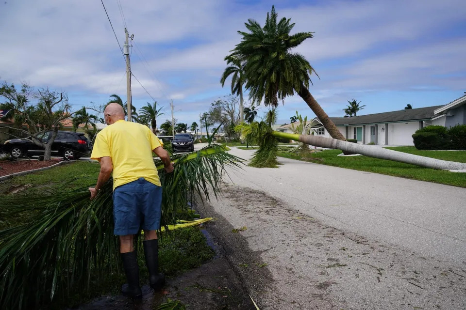
Tom Dee of Hamburg, N.Y., digs out on Nov. 18. More than 6 feet of snow was dumped on Buffalo and surrounding suburbs that weekend. (John Normile/Getty Images)
Regarded by millions of Americans as their favorite season, autumn for many regions of the United States has traditionally been marked by the gradual transition from hot summer weather to frigid winter temperatures. But in recent years, fall seems to have all but disappeared — especially in the Northeast — and experts say climate change is partly to blame.
Throughout October of this year, a time normally associated with crisp weather and changing leaves, many parts of the Northeast saw temperatures upwards of 70 degrees Fahrenheit. And then, seemingly overnight, the weather turned much colder.
In Spokane, Wash., the warmest October on record was quickly followed in early November by the season’s first freeze and snowfall. By the end of the third week in November, snow had fallen all over upstate New York, and Buffalo, N.Y., received a record-breaking 6 feet of snow.
Pedestrians in Buffalo attempt to dig out cars on Nov. 20 after a snowstorm slammed the area. (John Normile/Getty Images)
“We’re seeing this weather whiplash here in the fall, where it can be so warm, it can have record warm temperatures, and then very quickly we can transition into a very cold period,” Judah Cohen, director of seasonal forecasting at Atmospheric and Environmental Research, told Yahoo News.
Experts such as Cohen say climate change is a factor. Weather is fluky, and it’s impossible to ascribe most individual events to climate change, but climate change is creating the conditions, starting with a longer, hotter summer, that make fall-less years more likely.
Last year, the Associated Press reported that the fall foliage season was delayed by warmer weather from Maine to Oregon, and in some places it was ruined altogether by an unusually hot, dry summer that caused leaves to die prematurely.
“Summers are growing longer,” Cohen said. “September, a lot of times, acts more like August than what you traditionally consider a fall month. Summer is definitely encroaching on the fall season.”
“It’s staying warm later, for sure,” Matthew Barlow, a professor of climate science at the University of Massachusetts Lowell, told Yahoo News. “We’ve actually looked in the Northeast for fall weather patterns, and you can see that you get summer patterns later into fall.”
A student walks past fall foliage at the University of Virginia on Nov. 7. (Ryan M. Kelly/AFP via Getty Images)
One might expect, then, that typical fall weather would just be shifted until later in the year, as it would take longer for temperatures to drop to those historically associated with winter. But there’s another wrinkle attributed to climate change that explains why winter temperatures suddenly crash onto the country, plunging millions into winterlike conditions: warmer Arctic temperatures in places like Alaska that send polar vortices southward.
“I would summarize the whipsawing from weather extremes this fall as the summation of two competing factors: ambient warming due to increasing greenhouse gases and an increase in polar vortex stretching,” Cohen said.
This is the same reason that we are seeing more extreme winter weather, such as a massive snowstorm that hit the South last January. Recent research finds the polar vortex is more frequently getting stretched out, which also brings cold air south. The reason is uncertain but appears to be related to the dramatic loss of Arctic sea ice, according to a study led by Cohen that appeared in Science magazine last year.
But while extreme winter weather gets all the attention, the same phenomenon can happen in the fall, making a week in November feel more like January.
“Climate change — but specifically the changes in the Arctic — lead to more disruptions of the polar vortex, where the polar vortex kind of stretches, or elongates, like a rubber band,” Cohen said. “And we’re definitely seeing an increase in those types of events in October through December.”
Icebergs in Baffin Bay near Pituffik, Greenland, in July, as pictured by a drone during a NASA mission to measure melting Arctic sea ice. (Kerem Yucel/AFP via Getty Images)
“I think it’s applicable to what happened this fall, because we’ve had these unusual polar-vortex-stretching events,” Cohen added. “So in October, there was this early cold weather snap and early snow. And I know places in the Southeast were having the earliest freezes ever.”
“The cold snap that we’re seeing in November and extreme lake effects that we’re seeing here in western New York, that’s also associated with the stretched polar vortex event,” Cohen said, referring to the Buffalo snowstorm.
In a complementary phenomenon, the jet stream, a band of warm air flowing west to east, is also being destabilized by climate change. The jet stream is powered by the temperature differential between the Arctic and other regions, and the Arctic is warming four times faster than the rest of the Earth. As the difference in temperature decreases, a weakened jet stream is more frequently diverted southward, pulling a band of colder air above further south.
Scientists caution that the research on whether winter weather now strikes more frequently in fall, and why, isn’t as robust as the research showing that global warming is causing hot weather to last longer into the year.
A vehicle pulls over along I-190 during the snowstorm that hit the Buffalo area in November. (Carlos Osorio/Reuters)
“It’s certainly gotten cold here in a way that’s felt sudden, but I’m not really aware of anybody who has run those numbers to get at that variability piece of it,” Barlow said. “There isn’t a consensus on that, I think, yet, on whether there’s an increased breakdown or stretching of the polar vortex, or whether the jet stream is getting wavier, at least in the North Atlantic. There definitely is some evidence of that, but I don’t think there’s a consensus.”
The good news for people who want to take advantage of autumn’s outdoor rituals is that because polar-vortex-stretching events are temporary, the warm weather can sometimes bounce back. In Rhode Island, for example, the first freeze of the year in late October was followed by temperatures climbing back up to the 60s, just in time for trick-or-treating on Halloween.
Brain-eating amoeba infections keep spreading to new areas across the US
Andrea Michelson – November 23, 2022
A map from the Centers for Disease Control and Prevention shows brain-eating amoeba infections from 1962-2019.Centers for Disease Control and Prevention
At least three people died of brain-eating amoeba infections in the US this year.
The amoeba was found in lakes and rivers in Iowa, Nebraska, and Arizona.
As temperatures trend warmer, infections have been reported further north than in previous years.
In 2022, deadly brain-eating amoeba infections were recorded in states that had not seen the water-borne pathogen before.
The amoeba Naegleria fowleri thrives in warm freshwater — mostly lakes and rivers, but it’s also been found in public splash pads. If inhaled up the nose, the microscopic creature can cause a devastating brain infection known as primary amebic meningoencephalitis (PAM).
In past years, this has meant that health officials in southern states spend their summers on the lookout for reports of mysterious brain infections. However, the amoeba’s geographic footprint has expanded as temperatures warm across the US.
About three PAM infections are reported each year in the US, and they’re usually fatal.
By Insider’s count, there have been at least four infections in 2022. The Centers for Disease Control and Prevention have kept a record of PAM cases since 1962, but the agency has not released data for 2022 yet.
One reported case came from Florida, where a teenage boy continues to recover from an infection he contracted in July. The other three individuals who got sick lived further north, and they all died shortly after coming down with symptoms.
States like Florida, which has the most reported PAM infections after Texas, are better prepared to treat any brain infection in a swimmer like a PAM case. As global temperatures continue to rise, a larger swath of health officials will need to prepare for summer infections.
The first exposure in Iowa
A Missouri resident died of PAM in July after going swimming in an Iowa lake.
Iowa officials had not previously detected the amoeba in the state, but it’s possible that it was present in past years. The amoeba only causes harm to humans if it enters the nose, gaining access to the brain.
It was the first recorded case of the season, and the first of two PAM deaths in the Midwest in 2022.
Nebraska’s first recorded case
Nebraska confirmed its first death due to N. fowleri in August, after a child died of a rapidly progressing brain infection. The state had never reported a PAM infection before.
The child fell ill after swimming in the Elkhorn River, located a few miles west of Omaha. Officials later confirmed the amoeba was present in the child.
The river runs along a similar latitude to the Lake of Three Fires, as well as a Northern California lake where officials believe a 7-year-old contracted the amoeba last year.
Infections have been occurring in the northern half of the US with increasing frequency as temperatures rise and water levels drop, Douglas County health officials said at a news conference.
“Our regions are becoming warmer,” county health director Lindsey Huse said. “As things warm up, the water warms up and water levels drop because of drought, you see that this organism is a lot happier and more typically grows in those situations.”
A late infection in Arizona
The brain-eating amoeba is not new to Arizona, according to the CDC. The state has reported eight infections with PAM since 1962, and a Nevada resident died this year after a potential exposure in Arizona waters.
A Clark County, Nevada, resident under the age of 18 died after swimming in the Arizona side of Lake Mead, a reservoir that is split between the two states.
According to the Southern Nevada Health District, the boy went swimming in early October and developed symptoms about a week later. Most infections have been reported in June and July of previous years, so it’s possible the amoeba’s timeline is expanding along with its geographic territory.
Dreaming of beachfront real estate? Much of Florida’s coast is at risk of storm erosion that can cause homes to collapse, as Daytona just saw
Zhong-Ren Peng, Professor of Urban and Regional Planning,
University of Florida November 23, 2022
Dozens of homes were left unstable in the Daytona Beach area after Hurricane Nicole’s erosion. Joe Raedle/Getty Images
Back-to-back hurricanes left an unnerving scene on the Florida coast in November 2022: Several houses, and even swimming pools, were left dangling over the ocean as waves eroded the earth beneath them. Dozens of homes and condo buildings in the Daytona Beach area were deemed unsafe.
The destruction has raised a disturbing question: How much property along the rest of the Florida coast is at risk of collapse, and can it be saved?
As the director of iAdapt, the International Center for Adaptation Planning and Design at the University of Florida, I have been studying climate adaptation issues for the last two decades to help answer these questions.
Rising seas, aging buildings
Living by the sea has a strong appeal in Florida – beautiful beaches, ocean views, and often pleasant breezes. However, there are also risks, and they are exacerbated by climate change.
Sea level is forecast to rise on average 10 to 14 inches (25-35 cm) on the U.S. East Coast over the next 30 years, and 14 to 18 inches (35-45 cm) on the Gulf Coast, as the planet warms. Rising temperatures are also increasing the intensity of hurricanes.
With higher seas and larger storm surges, ocean waves more easily erode beaches, weaken sea walls, and submerge cement foundations in corrosive salt water. Together with subsidence, or sinking land, they make coastal living riskier.
The risk of erosion varies depending on the soil, geology and natural shoreline changes. But it is widespread in U.S. coastal areas, particularly Florida. Maps produced by engineers at the Florida Department of Environmental Protection show most of Florida’s coast faces critical erosion risk.
Aging or poorly maintained buildings and sea walls, and older or poor construction methods and materials, can dramatically aggravate the risk.
Designing better building codes
So, what can be done to minimize the damage?
The first step is to build sturdier buildings and fortify existing ones according to advanced building codes.
Building codes change over time as risks rise and construction techniques and materials improve. For example, design criteria in the Florida Building Code for South Florida changed from requiring some new buildings to be able to withstand 146 mph sustained winds in 2002 to 195 mph winds in 2021, meaning a powerful Category 5 hurricane.
The town of Punta Gorda, near where Hurricane Ian made landfall in October 2022, showed how homes constructed to the latest building codes have a much better chance of survival.
Many of Punta Gorda’s buildings has been rebuilt after Hurricane Charley in 2004, shortly after the state updated the Florida Building Code. When Ian hit, they survived with less damage than those in neighboring towns. The updated code had required new construction to be able to withstand hurricane-force winds, including having shutters or impact-resistant window glass.
Many homes in Punta Gorda fared better in Hurricane Ian’s winds because they had been rebuilt to higher standards after Hurricane Charley in 2002. Bryan R. Smith / AFP
However, even homes built to the latest codes can be vulnerable, because the codes don’t adequately address the environment that buildings sit on. A modern building in a low-lying coastal area could face damage in the future as sea level rises and the shoreline erodes, even if it meets the current flood zone elevation standards.
This is the problem coastal residents faced during Hurricanes Nicole and Ian. Flooding and erosion, exacerbated by sea-level rise, caused the most damage – not wind.
The dozens of beach houses and condo buildings that became unstable or collapsed in Volusia County during Hurricane Nicole might have seemed fine originally. But as the climate changes, the coastal environment changes, too, and one hurricane could render the building vulnerable. Hurricane Ian damaged sea walls in Volusia County, and some couldn’t be repaired before Nicole struck.
How to minimize the risk
The damage in the Daytona area in 2022 and the deadly collapse a year earlier of a condo tower in Surfside should be a wake-up call for all coastal communities.
Data and tools can show where coastal areas are most vulnerable. What is lacking are policies and enforcement.
Florida recently began requiring that state-financed constructors conduct a sea-level impact study before starting construction of a coastal structure. I believe it’s time to apply this new rule to any new construction, regardless of the funding source.
With Hurricane Nicole’s storm surge coinciding with high tide, the waves breached a condo tower’s sea walls in Daytona Beach in November 2022. Joe Raedle/Getty Images
A comprehensive sea-level impact study requirement should also allow for risk-based enforcement, including barring construction in high-risk areas.
Similarly, vulnerability audits – particularly for multistory buildings built before 2002 – can check the integrity of an existing structure and help spot new environmental risks from sea-level rise and beach erosion. Before 2002, the building standard was low and enforcement was lacking, so many of the materials and the structures used in those buildings aren’t up to the standards of today.
What property owners can do
There is a range of techniques homeowners can use to fortify homes from flood risks.
In some places, that may mean elevating the house or improving the lot grading so surface water runs away from the building. Installing a sump pump and remodeling with storm-resistant building materials can help.
FEMA suggests other measures to protect against coastal erosion, such as replenishing beach sand, strengthening sea walls and anchoring the home. Engineering can help communities, temporarily at least, through sea walls, ponds and increased drainage. But in the long term, communities will have to assess the vulnerability of coastal areas. Sometimes the answer is to relocate.
However, there’s a disturbing trend after hurricanes, and we’re seeing it with Ian: Many damaged areas see lots of money pouring in to rebuild in the same vulnerable locations. An important question communities should be asking is, if these are already in high-risk areas, why rebuild in the same place?
Hundreds of Arizona Households Set to Be Without Water by End of Year
Lauren Leffer – November 22, 2022
In every month of 2022, Lake Mead’s water level has been the lowest recorded for the time of year since the reservoir was first filled.
More than 500 households in the rural Arizona desert are set to be without running water starting January, 1 2023, as first reported by NBC News. The homes, located in Rio Verde Foothills—an affluent, unincorporated community in the state’s Maricopa County, were built without complying to Arizona’s usual 100-year water supply requirement. Rio Verde Foothills doesn’t have its own water system. Instead, people living in the arid locale rely on private wells or water trucked up from the nearby city of Scottsdale.
However, in response to the ongoing and worsening megadrought, Scottsdale declared late last year that it would cease hauling water to communities outside the city limits on Jan 1, 2023 and encouraged Rio Verde Foothills to find an alternative. Now, with the set deadline fast approaching, residents haven’t found a solution.
At the end of August, Maricopa County rejected a proposal from 550 Rio Verde residents hoping to form their own Domestic Water Improvement District. And though proposed deals have continued to be discussed behind closed doors, Scottsdale Progress reported, no firm decisions have been made and no community-wide fixes are underway.
Under Arizona’s Assured Water Supply Program, housing developments in the state are supposed to have a guaranteed century’s worth of water supply to be approved for construction. But via a semantic loophole, the around 2,200 houses in Rio Verde Foothills were able to skirt that law and be built without a clear long-term water source. Now, even many of the households that once had working wells are running dry.
Scottsdale has been warning for nearly a decade that its water-trucking operation was only ever meant to be a temporary remedy, not a permanent resolution, according to NBC News. And federal pressure amid the ongoing drought has forced the city to try to reduce its water usage.
Last year, when Scottsdale first said it would cease water hauling by January 2023, the U.S. Bureau of Reclamation had declared a Tier 1 water shortage on the Colorado River—reducing the amount of water Southwestern states can get from the river. In August of this year, the Reclamation Bureau upped the shortage designation to Tier 2a.
Scottsdale gets 65% of its water from the Colorado River, and ending its practice of exporting water beyond the city was intended to help Scottsdale lower its total consumption. In addition to cracking down on Rio Verde Foothills, the city has been encouraging its residents to voluntarily lower their usage. And though residents have made some progress and Scottsdale met its initial water reduction goals, the drought persists.
Lake Mead is at its lowest November water level on record since the reservoir was first filled. In fact, in every month of 2022, Lake Mead has been at record low for that time of year. Some seasonal fluctuations are to be expected, but this year’s monsoon season wasn’t nearly enough to make up the deficit. And climate change may be helping to propel already-arid U.S. regions into a permanent state of drought. One study published earlier this year found that 42% of the Southwest’s current drought is attributable to human-caused climate change.
Rio Verde Foothills is yet more evidence that when poor planning and the climate crisis come together, the result is often disastrous.
A Soil Fungus That Causes Lung Infections Is Spreading Across the U.S.
Nikki Main – November 21, 2022
The fungus histoplasma, which causes lung infections, was concentrated in the Midwest in the 1950s and 60s (top map), but now causes significant disease throughout much of the country (bottom).
An illness-causing fungus known as hisoplasma is in the soil of nearly all U.S. states, a new study suggests. The researchers behind the work say doctors may be relying on outdated risk maps and therefore missing diagnoses of the infections, which can sometimes be deadly.
According to the CDC, histoplasma, or histo, is found in the soil of central and eastern U.S. states, primarily in Ohio and the Mississippi River valleys. But that assumption is based on research from the 1950s and 1960s, says the team behind a new paper published in Clinical Infectious Diseases. When a person breathes in spores of the fungus, they can contract an infection called histoplasmosis.
“Every few weeks I get a call from a doctor in the Boston area – a different doctor every time – about a case they can’t solve,” said study author Andrej Spec, an associate professor of medicine at Washington University in St. Louis, in a press release. “They always start by saying, ‘We don’t have histo here, but it really kind of looks like histo.’ I say, ‘You guys call me all the time about this. You do have histo.’”
Lead author Patrick B. Mazi, a clinical fellow in infectious diseases also at Washington University in St. Louis, and his colleagues analyzed more than 45 million Medicare fee-for-service beneficiaries extending from 2007 through 2016. They looked at diagnoses across the country of three fungal diseases: histoplasmosis, coccidioidomycosis, and blastomycosis. Histo, the most common, was causing clinically relevant rates of illness in at least one county in 48 of 50 states, as well as Washington, D.C. The other two infections were each found in more than half of states.
“Fungal infections are much more common than people realize, and they’re spreading,” Spec said in the release. “The scientific community has underinvested in studying and developing treatments for fungal infections. I think that’s beginning to change, but slowly.” Climate change may be driving this spread as warming temperatures make more habitats suitable for the fungi.
While histo can be easily combatted in healthy adults, and many people who are exposed never develop symptoms, those who are immunocompromised as well as infants and people 55 years and older may develop more serious illness, including a cough, fever, chest, pain, body aches, and fatigue, according to the CDC. Symptoms appear within three to 17 days after exposure; most symptoms will go away within a month, but if it spreads from a person’s lungs, the illness can become severe and require months of treatment.
People can be exposed to histo and other fungal pathogens through activities that disrupt soil, like farming, landscaping, and construction. They can also be exposed inside caves and while working in basements and attics. Spec noted: “It’s important for the medical community to realize these fungi are essentially everywhere these days and that we need to take them seriously and include them in considering diagnoses.”
Finding safe haven in the climate change future: The Great Plains
David Knowles, Senior Editor – November 19, 2022
This Yahoo News series analyzes different regions around the country in terms of climate change risks that they face now and will experience in the years to come.
As the negative consequences of rising global temperatures due to humankind’s relentless burning of fossil fuels become more and more apparent in communities across the United States, anxiety over finding a place to live safe from the ravages of climate change has also been on the rise.
“Millions and likely tens of millions of Americans” will move because of climate through the end of the century, Jesse Keenan, an associate professor of real estate at Tulane University’s School of Architecture, told Yahoo News.“People move because of school districts, affordability, job opportunities. There are a lot of drivers, and I think it’s probably best to think about this as ‘climate is now one of those drivers.’”
The Buffalo Bayou in Houston. (Brandon Bell/Getty Images)
In late October, a report by the United Nations concluded that average global temperatures are on track to warm by 2.1°C to 2.9°C by the year 2100. As a result, the world can expect a dramatic rise in chaotic, extreme weather events. In fact, that increase is already happening. In the 1980s, the U.S. was hit with a weather disaster totaling $1 billion in damages once every four months on average. Thanks to steadily rising temperatures, they now occur every three weeks, according to a draft report of the latest National Climate Assessment, and they aren’t limited to any particular geographical region.
To be sure, calculating climate risk depends on a dizzying number of factors, including luck, latitude, elevation, the upkeep of infrastructure, long-term climate patterns, the predictable behavior of the jet stream and how warming ocean waters will impact the frequency of El Niño-La Niña cycles.
“No place is immune from climate change impacts, certainly in the continental United States, and throughout the U.S. those impacts will be quite severe,” Keenan said. “They will be more severe in some places and less severe in other places. Certain places will be more moderate in terms of temperature and some places will be more extreme, but we all share the risk of the increase of extreme events.”
In this installment, we look at the low-lying, expansive, north-south strip of states in the center of the country.
The Great Plains
A vast, predominantly flat stretch in the center of the country that extends from the Canadian border to the Gulf of Mexico, the Great Plains includesMontana, Wyoming, North Dakota, South Dakota, Nebraska, Kansas, Oklahoma and Texas.
While the large overall area of the Great Plains translates into markedly different weather — with North Dakota enduring frigid winters and states like Oklahoma and Texas baking in the summer months — the region has been warming quickly in recent years.
North Dakota, where the average annual temperature is 41.1°F, has warmed by an average of 2.6°F since the turn of the 20th century, according to data provided by the National Oceanic and Atmospheric Administration. Texas, where the average temperature is 65.8°F, has warmed by 1.5°F on average over that same period.
The bulk of that warming, we know, has occurred in recent decades because higher concentrations of greenhouse gases in the atmosphere have further amplified the greenhouse effect, speeding up the rate of temperature rise. Short of a technological breakthrough, unless concerted action is taken to stop burning fossil fuels to slow emissions, scientists say, the world will keep getting hotter.
Tumbleweed rolls across a dried-out landscape in central California’s Kern County. (Frederic J. Brown/AFP via Getty Images)
“The average annual Texas surface temperature in 2036 is expected to be 3.0°F warmer than the 1950-1999 average and 1.8°F warmer than the 1991-2020 average,” a 2021 report from the Texas state climatologist found. “The number of 100-degree days at typical stations is expected to nearly double by 2036 compared to 2001-2020, with a higher frequency of 100-degree days in urban areas.”
Texas, in fact, is home to all of the Great Plains’ top 10 worst-rated counties — Cameron, Galveston, Willacy, Kleberg, Refugio, Nueces, Pecos, Starr, Webb and Harris — in terms of overall climate change risks, according to information provided by data analytics firm the Rhodium Group and a 2020 analysis of counties in the lower 48 states published by ProPublica and the New York Times. And dozens of other Texas counties aren’t far behind on that list.
In no small part that’s because of two factors, the state’s latitude and its proximity to the Gulf of Mexico. The Rhodium rankings were based on six categories related to climate change: heat stress, the combination of heat and humidity (wet bulb), crop loss, sea level rise, very large fires and overall likely economic damages.
North Dakota’s Ward, Renville, Mountrail and Bottineau counties took the top four spots when it came to safest locations in the Great Plains for climate change risk, with the state also placing two more in the top 10 — Williams and Walsh counties. Montana’s Silver Bow, Glacier and Deer Lodge counties rated No. 5-No. 7 on that list, with Wyoming’s Uinta County ranking eighth-safest in the region.
Colter Bay Marina in Grand Teton National Park in Wyoming was closed for the summer due to the low water levels of Jackson Lake, seen here in August. (Amber Baesler/AP)
Summertime temperatures this year proved brutal for many states in the southern Great Plains, and drought conditions continued to worsen across the entire region.
On July 19, Oklahoma City set a new temperature record for that day, hitting 110°F during a heat wave that locked in triple-digit heat for more than a week. Yet all-time records, many of which were set in 1936 during the Dust Bowl years, were not surpassed.
Many climate deniers point to record high temperatures during the Dust Bowl years, which were amplified by poor farming practices, to try to show that global warming isn’t happening. If the records were set in the 1930s, the reasoning goes, then, by definition, the world is not warming.
That leaves out the fact that climate anomalies have continued to occur since humankind began pumping greenhouse gases into the atmosphere, that the incidence of heat waves is increasing and that the country on average continues to experience fewer days of extreme cold. In Houston, for example, five of the six hottest Julys on record have occurred since 2009, while the city’s top 10 coolest Julys all happened before 1980, according to data from the National Weather Service.
Skeptics who argue that humankind cannot influence something as large as the Earth’s climate also fail to address the impact that discarding harmful farming practices has had in preventing the return of Dust Bowl conditions. Yet rising temperatures and the continued depletion of the aquifers that help irrigate the Great Plains threaten that progress.
A sprinkler near Dodge City, Kan., in 2012. (Kevin Murphy/Reuters)
“Right now we are seeing more dust storms as this drought worsens in what was formerly the Dust Bowl region,” UCLA climate scientist Daniel Swain, who also consults for ClimateCheck, a company that provides climate change risk assessments on real estate nationwide, told Yahoo News. “Certainly nothing on the order of what we saw in the 1930s, but there is a severe, worsening drought there and there are some self-fulfilling feedback mechanisms whereby things start to get warm and dry, they dry out the soil, which begets more warmth and more dryness.”
As in other parts of the country, rising average temperatures in the Great Plains are wreaking havoc on the water cycle, specifically when it comes to sustaining water levels in the High Plains Aquifer. In the years to come, that could pose significant issues in the delivery of water for agriculture.
“In the northern portion of the Great Plains, rain can recharge the aquifer quickly. However, with climate change, precipitation in the winter and spring is projected to increasingly fall in the form of very heavy precipitation events, which can increase flooding and runoff that reduce water quality and cause soil erosion,” the EPA says on its website. “In the southern portion of the region, little recharge occurs, so declines in the aquifer’s water level are much greater. Climate change will worsen this situation by causing drier conditions and increasing the need for irrigation.”
While it is not entirely clear how climate change will impact precipitation trends across all of the Great Plains in the coming decades, there are warning signs in states like Montana, where the melting winter snowpack helps supply the region with water.
A serious drought has made it difficult to tell the difference between the prairie and the dirt road on the Cheyenne River Reservation near Dupree, S.D. (Jonathan Ernst/Reuters)
“Higher spring temperatures will also result in earlier melting of the snowpack, further decreasing water availability during the summer months,” the EPA says on its website.
More and more often, when it does rain across the Great Plains, it pours. Soil erosion, in turn, can set back the progress made to avert future Dust Bowls, and as evaporation rates rise in tandem with warmer temperatures, the threat of wildfires is also growing. Former Kansas State climatologist Mary Knapp has long warned that while agricultural advances have kept a 1930s disaster from recurring, climate change could yet plunge the Great Plains back into the danger zone.
“I’ve been saying that for years,” Knapp told the Mercury newspaper in Manhattan, Kan., in 2021. “The thought is, with modern agricultural and conservation techniques, that we would preclude the scenario that plagued the Dust Bowl, but there are other factors that can remove vegetation.”
Perhaps the surest climate change bet for the Great Plains is that warmer average temperatures will play out differently across a large region already accustomed to dramatic weather fluctuations. Some parts will have to deal with an uptick in what is known as the “wet bulb” effect, the potentially fatal combination of hot temperatures and high humidity that conspire to prevent the body from being able to cool itself down through the evaporation of sweat. That metric was one of the factors that explains why a place like Galveston County in Texas rated so poorly on the Rhodium analysis.
A heat advisory was issued in Dallas in July due to scorching weather. (Shelby Tauber/Reuters)
But climate change has also already disrupted the water cycle in other dangerous ways.
“In late August 2017, Hurricane Harvey ravaged the Houston area with 1 trillion gallons of rain, enough to run Niagara Falls for 15 days. No other big American city has withstood such a natural disaster in modern times,” Houston Mayor Sylvester Turner wrote in the introduction to the city’s 2020 plan on how to use billions in taxpayer funds to harden the city against the changing climate.
Harvey, which racked up $125 billion in damages and killed 107 people, and 2019’s Tropical Storm Imelda, which resulted in another $5 billion in damages and killed six, were both slow-moving systems that unloaded massive amounts of rain from an oversaturated atmosphere. In close succession, they shined a light on Houston’s vulnerability to flooding, but that’s not the only risk the city faces from rising global temperatures.
“Hurricanes, tropical storms, and flooding are not the only threats that we face. Houston is hot — and our heat is increasing due to climate change and the urban heat island effect,” Turner wrote.
Even though studies have shown that climate change is making tropical cyclones wetter, windier, slower and able to ramp up quicker than in a pre-climate-change world, persuading residents and elected officials to prepare for those risks is easier after they’ve witnessed the impacts firsthand.
People make their way down flooded Telephone Road in Houston in August 2017 in the wake of Tropical Storm Harvey. (Thomas Shea/AFP via Getty Images)
“If, for a location, the policy becomes [investing in] sea walls and sewage and drainage and stronger construction, better infrastructure and so forth, then places may be forecast to retain value and people may stay,” Parag Khanna, the founder and CEO of Climate Alpha, a company that helps investors quantify climate change risks to real estate, told Yahoo News.
“You can’t on the one hand continue to have the American dream rest on your property values going up, and on the other hand have people increasingly in survival society, being forced to rebuild time and again after disasters. Those two things are not compatible,” he added.
To be sure, hardening infrastructure from the daunting number of threats posed by climate change is quite expensive, but a reluctance to prepare can prove to be even more so.
In February 2021, a polar vortex descended on Texas, a state that years earlier had moved to deregulate its energy sector. The surging demand for electricity left more than 4.5 million homes and businesses without power. The storm essentially brought North Dakota-like winter conditions to the Lone Star State for days on end, resulting in the deaths of more than 170 people and more than $20 billion in damages, costing the state’s economy between $80 billion and $130 billion, according to the Dallas Federal Reserve.
As counterintuitive as it may sound, studies have since linked the severe winter outbreak to climate change. Thanks to the fact that the Arctic is warming faster than any other region on Earth, those higher temperatures have been shown to disrupt the behavior of polar vortexes, weakening them so that they wander south over the continental U.S.
That’s exactly what happened this week, when another high pressure ridge in Alaska sent another wave of cold arctic air over much of the country.
While the big picture is that the last eight years have been the warmest in recorded history, that warming will usher in an era of what scientists call “climate chaos,” in which a variety of new risks will present themselves. So, while states like Oklahoma and Texas have begun rolling out plans to help them endure hotter temperatures born of climate change, they also face a choice about how much to spend to winterize the electrical grid. Estimates for upgrading it so as to withstand a future polar vortex are anywhere between $5 billion and $20 billion, Texas Monthly reported.
West Texas earthquake causes damage hundreds of miles away
November 18, 2022
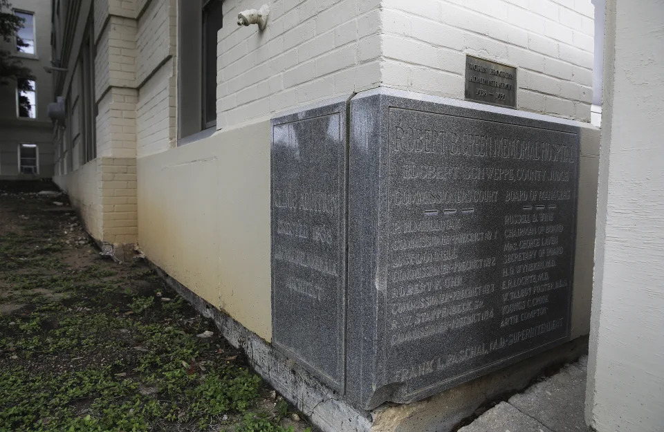
This May 24, 2021 photo shows the Robert B. Green hospital building, Bexar county’s original hospital that has been standing for more than 100 years, in San Antonio. A strong earthquake that struck a remote area of the West Texas desert on Wednesday, Nov. 16, 2022, caused damage in San Antonio, hundreds of miles from the epicenter, officials said. University Health said Thursday, Nov. 17, that the historical building was deemed unsafe because of damage sustained from the quake. (Kin Man Hui/The San Antonio Express-News via AP)This May 24, 2021 photo shows a historical marker on the corner of the old Robert B. Green Hospital building, Bexar county’s original hospital that has been standing for more than 100 years, in San Antonio. A strong earthquake that struck a remote area of the West Texas desert on Wednesday, Nov. 16, 2022, caused damage in San Antonio, hundreds of miles from the epicenter, officials said. University Health said Thursday, Nov. 17, that the historical building was deemed unsafe because of damage sustained from the quake. (Kin Man Hui/The San Antonio Express-News via AP) ASSOCIATED PRESS
University Health said Thursday that its Robert B. Green historical building was deemed unsafe because of damage sustained from the quake, which hit Wednesday in a remote area near the New Mexico border. The historical building is more than 100 years old and has been closed off for safety reasons, University Health said.
The quake initially had a 5.3 magnitude but that was revised upward to 5.4. The earthquake’s epicenter was about 23 miles (37 kilometers) south of Mentone, a tiny community about 350 miles (560 kilometers) northwest of San Antonio.
It was one of the strongest earthquakes on record in Texas and hit in an area known for oil and gas production. On Thursday, the state’s Railroad Commission — which regulates Texas’ oil and gas industry — sent inspectors to the site to determine whether any actions were needed.
Earthquakes in the south-central United States have been linked to oil and gas production, particularly the underground injection of wastewater. The U.S. Geological Survey said research suggests that a 5.0 magnitude quake that struck the same West Texas area in 2020 was the result of a large increase of wastewater injection in the region.
In neighboring Oklahoma, thousands of earthquakes of varying magnitudes have been recorded in the past decade, leading state regulators to direct producers to close some injection wells.
Red tide update: State report shows toxic algae levels from Sarasota south to Marco Island
Chad Gillis, Fort Myers News-Press – November 17, 2022
Scientists are saying a red tide bloom that’s lingered along the coast for a few weeks is now being fed by nutrients running off the landscape in the wake of Hurricane Ian.
Red tide (Karenia brevis) is a naturally occurring organism in the Gulf of Mexico that sometimes blooms to toxic levels.
But research shows that nutrients from farm fields, lawns and septic tanks fuel red tide blooms close to shore — making them more frequent, longer-lasting and more intense.
“I don’t see any good evidence that hurricanes initiate a red tide, but once you have a red tide started, runoff will make it worse,” said Larry Brand, a water quality expert, scientist and professor at the University of Miami.
Ian didn’t create the conditions for the original bloom; but rain water and storm surge has helped fuel the bloom, which now stretches from the Sarasota area south to Marco Island.
Counts of 1 million cells per liter and higher have been reported at multiple locations along the Southwest Florida coast.
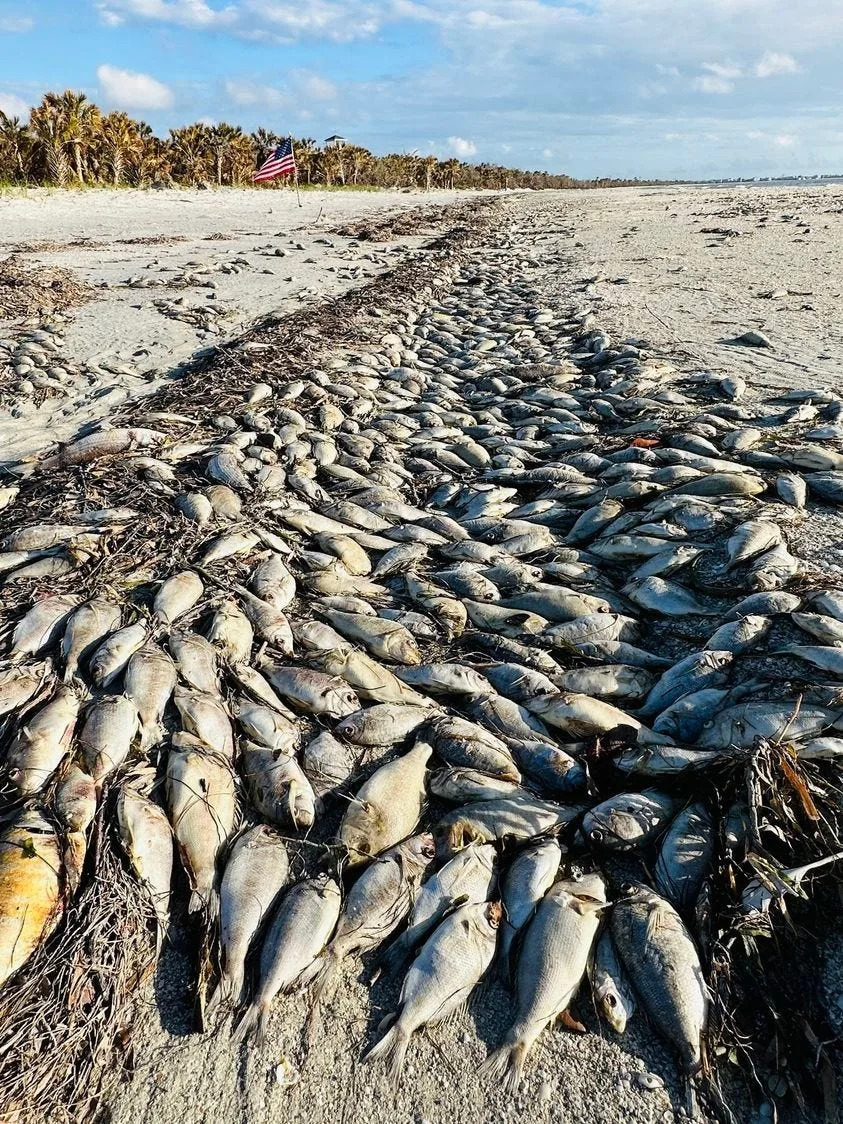
Dead fish litter many beaches in the region, and the Florida Department of Health in Collier County issued an exposure advisory Wednesday.
DOH agrees with Brand, that nutrients flowing off the landscape contribute to the intensity and duration of the bloom.
Thousands of dead fish line the high tide line at Cayo Costa State Park on Nov. 14, 2022. Red tide has moved into Lee County waters in recent weeks.
“Once inshore, these opportunistic organisms can use nearshore nutrient sources to fuel their growth,” a Wednesday DOH press release reads. “Blooms typically last into winter or spring, but in some cases, can endure for more than one year.”
What should Southwest Florida residents do?
DOH says people who live along the coast should even check their air conditioning filters.
“Residents living in beach areas are advised to close windows and run the air conditioner, making sure that the A/C filter is maintained according to manufacturer’s specifications,” DOH says. “If outdoors near an affected location, residents may choose to wear masks, especially if onshore winds are blowing.”
Carly Jones, spokeswoman for the Florida Fish and Wildlife Conservation Commission — the state agency charged with monitoring red tide, said offshore winds can help push the contaminated waters and the microscopic algae away from the coast.
The latest FWC report show the strongest red tide counts have been found in northern Lee and Sarasota counties.
“Some people experience respiratory irritation (coughing, sneezing, tearing and an itchy throat) when the red tide organism is present and winds blow onshore,” Jones wrote in an email to The News-Press. “Offshore winds usually keep respiratory effects experienced by those on the shore to a minimum. The Florida Department of Health advises people with severe or chronic respiratory conditions, such as emphysema or asthma, to avoid red tide areas.”
Red tide can contaminate shellfish, and the DOH recommends against collecting and eating shellfish from this region at this time.
Locally caught, properly cleaned and cooked fish can be eaten, the press release says.
DOH recommends washing yourself and all clothing if you make contact with waters containing the toxic algae.
Hurricane Irma also stirred nutrients in toxic algae bloom in 2017
Calusa Waterkeeper John Cassani has been monitoring the bloom online.
“I’m hearing people aren’t seeing as many gamefish species as compared to (Hurricane) Irma (2017),” Cassani said. “It’s mostly foraging fish but most are decayed to the point you can’t determine the species.”
Hurricane Irma stirred up nutrients in the Lake Okeechobee/Caloosahatchee River system five years ago, and the following summer was virtually lost to a massive red tide and blue-green algae bloom in the river.
Lee County was part of a state of emergency for both blooms.
Some scientists have speculated that Hurricane Ian’s aftermath will cause similar conditions between now and the spring of 2024.
The Hurricane Irma-fed red tide lasted from the fall of 2017 until the spring of 2019.
“It’s a neurotoxin,” Cassani said. “There are neurological symptoms that have been defined in response for red tide. And people with asthma are showing up in emergency rooms. There’s an influx often during a bloom. It’s an unregulated contaminant.”
Red tide worsens and spreads to Tampa Bay. Dead fish found on Anna Maria Island
Ryan Ballogg – November 16, 2022
A red tide bloom has worsened in Southwest Florida waters this week, the latest samples from the state show.
The algae that causes red tide, Karenia brevis, was observed at elevated levels in Tampa Bay, around Anna Maria Island, Longboat Key and in Sarasota Bay. Dead fish and breathing irritation have been reported on local beaches.
The bloom remains most intense further south offshore of Sarasota, Charlotte and Lee counties, according to samples from the Florida Fish and Wildlife Conservation commission.
On Monday, a very low concentration of red tide algae was detected in a water sample near the Rod and Reel Pier in Anna Maria —down from medium levels last week— and a medium concentration was again found in waters near Longboat Pass in Bradenton Beach.
University of South Florida’s red tide for predicts that very low levels of the algae will continue to circulate around Anna Maria Island through this weekend. At very low levels, respiratory irritation is possible.
USF predicts that low to medium levels of the algae will circulate around Longboat Key, with high levels persisting farther south in Sarasota Bay.
At levels of medium and above, which are considered “bloom concentrations” of the algae, respiratory irritation and fish kills are likely.
Slight breathing irritation and a few dead fish were reported on Anna Maria Island beaches this week, Mote Marine Laboratory’s red tide beach conditions report said. To the south, moderate breathing irritation and numerous dead fish were observed on several Sarasota County beaches.
Red tide’s patchy nature means that even beaches in close proximity can have very different conditions. Respiratory irritation and dead fish can also become more or less present as wind directions and tides change.
The National Oceanic and Atmospheric Administration forecasts the respiratory threat from red tide. On Wednesday, NOAA warned that beachgoers in Manatee, Sarasota, Charlotte, Lee and Collier counties could experience moderate to high levels of respiratory irritation over the next 36 hours.
On Monday, the Florida Department of Health Manatee County issued a red tide health alert for the following beaches:
Bayfront Park
Coquina Beach South
Longboat Pass/Coquina Boat Ramp
Rod and Reel Pier (City of Anna Maria Island)
FDOH-Manatee offers the following red tide safety tips:
Look for informational signage posted at most beaches.
Stay away from the water.
Do not swim in waters with dead fish.
Those with chronic respiratory problems should be especially cautious and stay away from these locations as red tide can affect your breathing.
Do not harvest or eat molluscan shellfish or distressed or dead fish from these locations. If caught live and healthy, finfish are safe to eat as long as they are filleted and the guts are discarded. Rinse fillets with tap or bottled water.
Wash your skin and clothing with soap and fresh water if you have had recent contact with red tide.
Keep pets and livestock away and out of the water, sea foam and dead sea life. If your pet swims in waters with red tide, wash your pet as soon as possible.
Residents living in beach areas are advised to close windows and run the air conditioner, making sure that the A/C filter is maintained according to manufacturer’s specifications.
If outdoors near an affected location, residents may choose to wear masks, especially if onshore winds are blowing.
Global population passes 8 billion, says UN amid concerns of impact on climate crisis
Sravasti Dasgupta – November 15, 2022
The world population has crossed eight billion, the United Nations said on Tuesday as it warned of the impact of climate change and resource scarcity.
John Wilmoth, director of the UN’s population division said that reaching eight billion people is “a sign of human success, but it’s also a great risk for our future”.
According to a statement by the UN, the global population is growing at its slowest rate since 1950.
UN projections suggest that the global population could grow to around 8.5 billion in 2030 and 9.7 billion in 2050.
It is projected to reach a peak of around 10.4 billion people during the 2080s and to remain at that level until 2100.
The figures were earlier released by the UN in a report ahead of World Population Day in July.
“China and India, with more than 1.4 billion each, accounted for most of the population in these two regions,” the report said.
“India is projected to surpass China as the world’s most populous country in 2023,” it added.
Despite the global population increasing, experts say that the growth rate has fallen steadily to less than 1 per cent per year.
“A big part of this story is that this era of rapid population growth that the world has known for centuries is coming to an end,” Mr Wilmoth said.
Experts have warned that the rising population combined with the impact of climate change will adversely affect vulnerable nations and people.
Deborah Balk, a demographic researcher at the City University of New York, said: “African cities will, on average, grow.”
Ms Balk said that this will leave millions more urban dwellers exposed to climate threats such as rising seas.
Analysts warn that there will also be resource scarcity with the population rise.
“Every single person needs fuel, wood, water, and a place to call home,” said Stephanie Feldstein, population and sustainability director at Center for Biological Diversity.
UN officials have also said that rising population is likely to impact achieving sustainable development goals.
“The relationship between population growth and sustainable development is complex and multidimensional” said Liu Zhenmin, UN Under-Secretary-General for Economic and Social Affairs in a statement.
“Rapid population growth makes eradicating poverty, combatting hunger and malnutrition, and increasing the coverage of health and education systems more difficult.
“Conversely, achieving the Sustainable Development Goals, especially those related to health, education and gender equality, will contribute to reducing fertility levels and slowing global population growth.”