18,000 cows killed in explosion, fire at Texas dairy farm may be largest cattle killing ever

USA Today

18,000 cows killed in explosion, fire at Texas dairy farm may be largest cattle killing ever

Rick Jervis, USA TODAY – April 12, 2023

The fire spread quickly through the holding pens, where thousands of dairy cows crowded together waiting to be milked, trapped in deadly confines.

After subduing the fire at the west Texas dairy farm Monday evening, officials were stunned at the scale of livestock death left behind: 18,000 head of cattle perished in the fire at the South Fork Dairy farm near Dimmitt, Texas – or nearly three times the number of cattle led to slaughter each day across the U.S.

A dairy farm worker rescued from inside the structure was taken to an area hospital and was in critical but stable condition as of Tuesday. There were no other human casualties.

Special report: ‘We don’t seem to learn’: The West, Texas, fertilizer plant explosion, 10 years later

“It’s mind-boggling,” Dimmitt Mayor Roger Malone said of the number of bovine deaths. “I don’t think it’s ever happened before around here. It’s a real tragedy.”
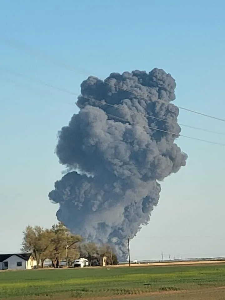
The Castro County Sheriff's Office was among several agencies to respond to a fire and explosion at a dairy farm near Dimmitt on Monday.
The Castro County Sheriff’s Office was among several agencies to respond to a fire and explosion at a dairy farm near Dimmitt on Monday.

It was the biggest single-incident death of cattle in the country since the Animal Welfare Institute, a Washington-based animal advocacy group, began tracking barn and farm fires in 2013.

That easily surpassed the previous high: a 2020 fire at an upstate New York dairy farm that consumed around 400 cows, said Allie Granger, a policy associate at the institute.

“This is the deadliest fire involving cattle we know of,” she said of the Texas incident. “In the past, we have seen fires involving several hundred cows at a time, but nothing anything near this level of mortality.”

Where was the Texas cattle fire?

Castro County, where the fire occurred, is open prairie land dotted with dairy farms and cattle ranches, about 70 miles southwest of Amarillo.

Pictures posted on social media by bystanders showed the large plume of black smoke lifting from the farm fire, as well as charred cows that were saved from the structure.

What caused the dairy farm explosion?

A malfunction in a piece of equipment at the South Fork Dairy farm may have caused an explosion that led to the fire, said County Judge Mandy Gfeller, the county’s top executive. Texas fire officials are still investigating the exact cause, she said.

Malone, the mayor, said he wasn’t aware of any previous fires reported at the facility. He said the dairy had opened in the area just over three years ago and employed between 50 to 60 people.

The owners of South Fork Dairy couldn’t be reached for comment.

How many cows were killed in the dairy fire?

Most of the perished animals – a mix of Holstein and Jersey cows – were in a large holding pen before being milked, she said. The 18,000 cows represented about 90% of the farm’s total herd.

With each cow valued roughly at around $2,000, the company’s losses in livestock could stretch into the tens of millions of dollars, Gfeller said. That doesn’t include equipment and structure loss.

“You’re looking at a devastating loss,” she said. “My heart goes out to each person involved in that operation.”

How did the Texas dairy compare with the rest of the country?
Cattle stranded in a flooded pasture in La Grange, Texas, after Hurricane Harvey in 2017. The storm drowned thousands of cattle in southeast Texas.

Texas ranks fourth nationally in milk production, home to 319 Grade A dairies with an estimated 625,000 cows producing almost 16.5 billion pounds of milk a year, according to the Texas Association of Dairymen, a trade group.

And Castro County is the second-highest producing county in Texas, with 15 dairies producing 148,000 pounds of milk a month, according to the U.S. Department of Agriculture.

Even by Texas standards, South Fork Dairy was a behemoth. Its 18,000 cattle made it nearly 10 times larger than the average dairy herd in Texas.

It’s not the first time large numbers of Texas cattle have died, but rarely do so many perish from a single fire. A blizzard in December 2015 killed off around 20,000 cattle across the Texas panhandle, according to the Texas Association of Dairymen.

And Hurricane Harvey in 2017 drowned thousands more in Southeast Texas, leading to $93 million in livestock losses across the state, according to Texas A&M AgriLife Extension Service.

What happens next?

Now, state and dairy officials are turning to the massive, messy task of cleaning up 18,000 charred cow carcasses. On its website, the Texas Commission on Environmental Quality lists several rules for onsite burial of carcasses, including burying the animal at least 50 feet from the nearest well and recording GPS coordinates of the site. Nowhere does it mention mass graves, however.

TCEQ and the AgriLife Extension Service are teaming up to assist in the clean up effort, officials said.

Malone, Dimmitt’s mayor, said he’s taken emergency management courses that teach how to dispose of animal carcasses after a disaster, just not at this scale.

“How do you dispose of 18,000 carcasses?” he said. “That’s something you just don’t run into very much.”

Americans Are Dying Younger—But Where You Live Makes a Big Difference

Time

Americans Are Dying Younger—But Where You Live Makes a Big Difference

Jeremy Ney – April 12, 2023

US-SHOOTING-SCHOOL
US-SHOOTING-SCHOOL

Alexander Reddy, who’s friend’s little sister is Hallie Scruggs, pays respects at a makeshift memorial for victims by the Covenant School building at the Covenant Presbyterian Church following a shooting, in Nashville, Tennessee, March 28, 2023. – A heavily armed former student killed three young children and three staff in what appeared to be a carefully planned attack at a private elementary school in Nashville on March 27, before being shot dead by police. Credit – BRENDAN SMIALOWSKI-AFP

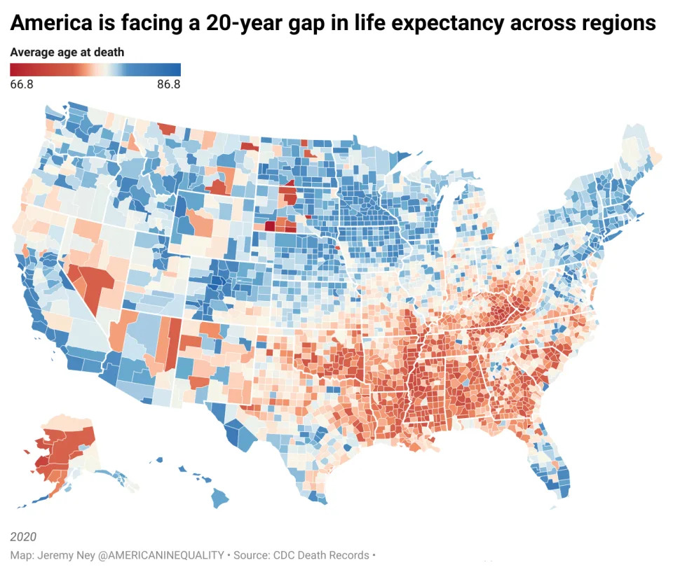
The average U.S. life expectancy has hit its worst decline in 100 years and America’s standing is dismal among peer nations. But the average obscures a more complex story. The United States is facing the greatest divide in life expectancy across regions in the last 40 years. Research from American Inequality found that Americans born in certain areas of Mississippi and Florida may die 20 years younger than their peers born in parts of Colorado and California.

The decline is not occurring equally throughout the country. In the land of opportunity, millions of people are not even given a fair shot at life.

America is facing 20 year gap in life expectancy across the country<span class="copyright">Credit to Jeremy Ney @ AmericanInequality</span>
America is facing 20 year gap in life expectancy across the countryCredit to Jeremy Ney @ AmericanInequality

America is unique among wealthy countries when it comes to how young people die, and the trend is only getting worse. From 2019 to 2020, U.S. life expectancy declined by almost 2 years according to the Center Disease Control and Prevention (CDC), the worst two-year decline since 1921-1923. When Covid hit, America experienced a larger decline in life expectancy than any other wealthy country. Life expectancy in America is now 76 years.

What is driving the differences in who lives and who dies in America? The answer is wealth, demographics, and location.

State policies tremendously influence life expectancy. Income support, medicaid expansion, stronger gun control, drug overdose prevention, and safe abortion access are among the drivers of regional divides in life expectancy. Overdoses kill more than 100,000 people each year. Guns kill more people than cars do. But digging into communities shed light on the country’s biggest issues.

More from TIME
Wealthier Americans live longer

Income is a major driver of higher life expectancies. In the wealthiest regions like Aspen, Colorado and Santa Clara, California, median household incomes reach the hundreds of thousands of dollars and Americans live to 87 on average, the highest in the country. But in poorer regions like or Owsley County, Kentucky or Union County, Florida, the median household income is $35,000 and life expectancy floats around 67 on average, the lowest in the country.

Our research has found a painfully high correlation between household income and life expectancy.

Created with Datawrapper

Poverty in America is not about income alone. Low-income communities, regardless of the state, are more likely to struggle with access to affordable healthcare; they are more likely to live near toxic sites and develop lung cancer; they are more likely to live in food deserts and wrestle with illnesses like heart disease and obesity; and they are more likely to die younger from drug overdoses.

Adequately addressing inequality in life expectancy requires looking across factors and working to improve these challenges for communities.

Black communities die younger

Thomas McGuire, professor of health economics at Harvard Medical School, explained, “In terms of health, there’s approximately a five-year penalty for being African-American compared to being a White male.”

Black Americans in every state have lower life expectancies than their White peers by 4 years on average. This is largely due to the lower-quality care that Black communities receive for conditions like cancerheart problems, pneumoniapain managementprenatal and maternal health, and overall preventive health.

Pemiscot County, Missouri represents this gap most clearly as it has one of the lowest Black life expectancies in America. In Pemiscot, Black residents die at 64 on average, effectively meaning that they will work until they die. 1 in 4 residents in Pemiscot is Black. Pemiscot has one public hospital that almost closed in 2013 and it’s one of the poorest counties in Missouri.

State policies make a big difference

States in the Deep South have lower life expectancies than states north of the Mason-Dixon line. These five factors may be the reasons why the residents of some states live far longer.

1. Expanding the EITC and CTC: More money means more time alive, and certain programs which put cash directly into low-income homes have improved life expectancy. The Earned Income Tax Credit (EITC) and Child Tax Credit (CTC) federally have been some of America’s most successful poverty alleviation programs, but 11 states have enacted their own CTC programs and 31 states have implemented their own EITC programs, putting more cash into the most needy homes. Residents in states that have adopted both the EITC and CTC tend to live 2 years longer than states which have implemented neither. This may even be more cost effective at increasing life expectancy than many other policies. These programs are designed to support children, too.

Created with Datawrapper

2. Medicaid Expansion: States that expanded Medicaid saved more than 200 lives per every 100,000 people and decreased the risk of premature death by roughly 50% for older adults who gained coverage. As Nobel-Prize wining economist Paul Krugman explained, “Some of the poorest states in America, with the lowest life expectancy, are still refusing to expand Medicaid even though the federal government would cover the bulk of the cost.” Such individuals in turn are therefore at the mercy of policies that differ state to state.

3. Gun Control: Stronger gun control measures in states also improve life expectancy. The South, which has some of the most lenient gun control measures, lost 5.7 million years of life expectancy in the period 2009-2018 from firearm related deaths. Conversely, Northeastern states, which tend to have much stronger gun control measures like background checks and secure storage laws, had one-fifth the loss in life expectancy. Guns are now the #1 killer of children in America and 1 in 25 American 5-year olds now won’t live to see 40, largely due to guns. If we stopped these deaths, it would effectively add 3 years of life to every 5-year old in the South.

4. Drug Overdose Prevention: States that introduced policies to prevent drug overdose deaths saw life expectancies increase by 11%. The CDC estimates that half of all the unintentional deaths last year that took people’s lives too early were attributed to drug overdoses. The Food and Drug Administration (FDA) recently approved Naloxone to be sold over the counter at pharmacies, which could help close the state-by-state gap. In the meantime, McDowell County, West Virginia has one of the lowest life expectancies in the country and has the highest rate of opioid overdoses in the country.

5. Abortion Access: Lastly, while the data has not fully revealed the impact of the Supreme Court’s ruling in Dobbs v. Jackson, this decision may drive further divides in life expectancy for Southern states that have in turn limited abortion access. Arkansas has a maternal mortality rate that is 50% higher than the national average. In Mississippi, it is 75x more dangerous for women to carry a pregnancy to term than to have an abortion due to poor healthcare. Mississippi has the lowest life expectancy in America at 71. Causing more women to carry a pregnancy to term may increase deaths of mothers in their 20s-40s.

The 20-year gap in life expectancy across regions tells story of America. The divide is deeply interwoven with healthcare, housing, race, gender, location, education, and more. But improving life expectancy across regions in possible and it starts with state legislatures. States can learn from each other about what has worked best and implement new policies with proven effectiveness. Data will be the driving force for finding patterns of inequality and leading change-makers towards solutions that engender equality.

Study warns critical ocean current is nearing ‘collapse.’ That would be a global disaster.

USA Today

Study warns critical ocean current is nearing ‘collapse.’ That would be a global disaster.

Doyle Rice, USA Today – April 11, 2023

Due to global warming, a deep ocean current around Antarctica that has been relatively stable for thousands of years could head for “collapse” over the next few decades.

Such a sudden shift could affect the planet’s climate and marine ecosystems for centuries to come.

So says a recent study that was published in the peer-reviewed journal Nature.

The cold water that sinks near Antarctica drives the deepest flow of a network of currents that spans throughout the world’s oceans, known as the overturning circulation. The overturning carries heat, carbon, oxygen and nutrients around the globe.

This in turn influences climate, sea level and the productivity of marine ecosystems. Indeed, the loss of nutrient-rich seawater near the surface could damage fisheries, according to the study.

‘Headed towards collapse’

This deep ocean current has remained in a relatively stable state for thousands of years, but with increasing greenhouse gas emissions and the melting of Antarctic ice, Antarctic overturning is predicted to slow down significantly over the next few decades.

“Our modeling shows that if global carbon emissions continue at the current rate, then the Antarctic overturning will slow by more than 40% in the next 30 years – and on a trajectory that looks headed towards collapse,” said study lead author Matthew England of the University of New South Wales in Australia.

Speaking about the new research, paleoclimatologist Alan Mix told Reuters “that’s stunning to see that happen so quickly.” Mix, a paleoclimatologist at Oregon State University and co-author on the latest Intergovernmental Panel on Climate Change assessments, who was not involved in the study, added “It appears to be kicking into gear right now. That’s headline news.”

‘Uncharted levels’: Gases fueling climate change still rising at an alarming rate, NOAA says

Atlantic current also affected

Such a collapse would also impact a nearby Atlantic Ocean current, known as the Atlantic Meridional Overturning Circulation, or AMOC, which transports warm, salty water from the tropics northward at the ocean surface and cold water southward at the ocean bottom.

This current includes the well-known Gulf Stream, which affects weather patterns in the U.S. and Europe. “The main issue for the AMOC at the moment is meltwater from Greenland, which slows that current,” England told USA TODAY.

Other studies in recent years about the AMOC drew comparisons to the scientifically inaccurate 2004 disaster movie “The Day After Tomorrow,” which used such an ocean current shutdown as the premise of the film. In a 2018 study, authors said a collapse was at least decades away but would be a catastrophe.

The Day after Tomorrow?: Study warns of ‘irreversible transition’ in ocean currents that could rapidly freeze parts of North America

An Antarctic "tidewater" glacier meets the ocean in this 2018 photo that also shows sea ice floating on the water's surface.
An Antarctic “tidewater” glacier meets the ocean in this 2018 photo that also shows sea ice floating on the water’s surface.
Cause of the current slowdown

What’s causing the currents to slow down and potentially collapse? “Climate change is to blame,” England wrote for the Conversation. “As Antarctica melts, more freshwater flows into the oceans. This disrupts the sinking of cold, salty, oxygen-rich water to the bottom of the ocean”.

Specifically, more than 250 trillion tons of that cold, salty, oxygen-rich water sinks near Antarctica each year. This water then spreads northward and carries oxygen into the deep Indian, Pacific and Atlantic Oceans.

“If the oceans had lungs, this would be one of them,” England said.

“Simply put, a slowing or collapse of the overturning circulation would change our climate and marine environment in profound and potentially irreversible ways.” he wrote.

Climate change and hurricanes: Climate change could push more hurricanes toward US coasts, new study suggests

How would it impact the US?

England told USA TODAY that the main impact for North America would be sea-level rise along the East Coast.

In addition, another impact of the collapse of the AMOC would be a transition to a more La Nina-like-state in the Pacific Ocean, England said. La Niña, a natural cooling of sea water in the tropical Pacific Ocean, affects weather and climate in the U.S. and around the world.

It tends to lead to worsening droughts and wildfires in the Southwest U.S., and more hurricanes in the Atlantic Ocean.

What can be done?

“Our study shows continuing ice melt will not only raise sea levels, but also change the massive overturning circulation currents which can drive further ice melt and hence more sea-level rise, and damage climate and ecosystems worldwide,” England wrote in the Conversation. “It’s yet another reason to address the climate crisis – and fast.”

Contributing: The Associated Press

Volcano eruption in Russia’s Kamchatka spews vast ash clouds

Associated Press

Volcano eruption in Russia’s Kamchatka spews vast ash clouds

Associated Press – April 11, 2023

Smoke and ash are visible during the the Shiveluch volcano’s eruption on the Kamchatka Peninsula in Russia, Tuesday, April 11, 2023. Shiveluch, one of Russia’s most active volcanoes, erupted Tuesday, spewing clouds of ash 20 kilometers into the sky and covering broad areas with ash. (Alexander Ledyayev via AP)

MOSCOW (AP) — A volcano erupted early Tuesday on Russia’s far eastern Kamchatka Peninsula, spewing clouds of dust 20 kilometers (65,600 feet) into the sky and covering broad areas with ash.

The ash cloud from the eruption of Shiveluch, one of Kamchatka’s most active volcanoes, extended over 500 kilometers (more than 300 miles) northwest and engulfed several villages in grey volcanic dust.

Officials closed the skies over the area to aircraft. Local authorities advised residents to stay indoors and shut schools in several affected communities. Two villages had their power supplies cut for a few hours until emergency crews restored them.

Ash fell on 108,000 square kilometers (41,699 square miles) of territory, according to the regional branch of the Russian Academy of Sciences Geophysical Survey. Scientists described the fallout as the biggest in nearly 60 years.

The village of Klyuchi, which is located about 50 kilometers (some 30 miles) from the volcano, was covered by an 8-centimeter (3-inch) layer of dust. Residents posted videos showing the ash cloud plunging the area into darkness.

Kamchatka Gov. Vladimir Solodov said there was no need for mass evacuation, but added that some residents who have health issues could be temporarily evacuated.

Shiveluch has two parts, the 3,283-meter (10,771-foot) Old Shiveluch, and the smaller, highly active Young Shiveluch.

The Kamchatka Peninsula, which extends into the Pacific Ocean about 6,600 kilometers (4,000 miles) east of Moscow, is one of the world’s most concentrated area of geothermal activity, with about 30 active volcanoes.

Sea levels rising rapidly in southern U.S., study finds

Yahoo! News

Sea levels rising rapidly in southern U.S., study finds

Ben Adler, Senior Editor – April 10, 2023

Damage after Hurricane Ian Bonita Springs, Fla., Sept. 29, 2022
Damage after Hurricane Ian Bonita Springs, Fla., Sept. 29, 2022. (Sean Rayford/Getty Images)

A study published Monday finds sea-level rise along the coast of the southeastern United States has accelerated rapidly since 2010, raising fears that tens of millions of Americans’ homes in cities across the South will be at risk from flooding in the decades to come.

“It’s a window into the future,” Sönke Dangendorf, an assistant professor of river-coastal science and engineering at Tulane University, who co-authored the study that appeared in Nature Communications, told the Washington Post.

That paper and another published last month in the Journal of Climate find that sea levels along the Gulf Coast and the southern Atlantic Coast have risen an average of 1 centimeter per year since 2010. That translates to nearly 5 inches over the last 12 years, and it is about double the rate of average global sea-level rise during the same time period.

The Journal of Climate study found that the hurricanes that have recently hammered the Gulf Coast, including Michael in 2018 and Ian — which was blamed in the deaths of 109 Floridians last year — had a more severe impact because of higher sea levels.

“It turns out that the water level associated with Hurricane Ian was the highest on record due to the combined effect of sea-level rise and storm surge,” Jianjun Yin, a climate scientist at the University of Arizona and the author of the Journal of Climate study, told the Post.

Residents of Houston evacuate their homes after the area was flooded from Hurricane Harvey, Aug. 28, 2017
Residents of Houston evacuate their homes after the area was flooded from Hurricane Harvey, Aug. 28, 2017. (Joe Raedle/Getty Images)

Data from the National Oceanic and Atmospheric Administration (NOAA) show the water level at Lake Pontchartrain, an estuary bordering New Orleans, is eight inches higher than it was in 2006. Other cities threatened by rising oceans in the region include Houston, Miami and Mobile, Ala.

The centimeter-per-year rate is far faster than experts had expected, and it is more in line with projections made for the end of the century, Dagendorf said. High-tide flooding — when the tides bring water onto normally dry land on rain-free days — has more than doubled on the Gulf Coast and Southeast coast since the beginning of this century, according to NOAA. Recent years have seen records for high-tide flooding obliterated. The city of Bay St. Louis, Miss., went from three days of high-tide flooding in 2000 to 22 days in 2020.

A study by scientists with the University of Miami, NOAA, NASA and other institutions, which has not yet undergone peer review, found that the Southeastern sea-level rise accounted for “30%-50% of flood days in 2015-2020.”

“In low-lying coastal regions, an increase of even a few centimeters in the background sea level can break the regional flooding thresholds and lead to coastal inundation,” the study said.

Miami and New Orleans face greater sea-level threat than already feared

Miami and New Orleans face greater sea-level threat than already feared

Richard Luscombe – April 10, 2023

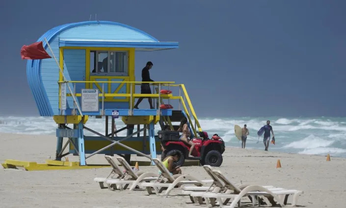
<span>Photograph: Wilfredo Lee/AP</span>
Photograph: Wilfredo Lee/AP

Coastal cities in the southern US, including Miami, Houston and New Orleans, are in even greater peril from sea-level rise than scientists already feared, according to new analysis.

What experts are calling a dramatic surge in ocean levels has taken place along the US south-eastern and Gulf of Mexico coastline since 2010, one study suggests, an increase of almost 5in (12.7cm).

That “burst”, more than double the global average of 0.17in (0.44cm) per year, is fueling ever more powerful cyclones, including Hurricane Ian, which struck Florida in September and caused more than $113bn of damage – the state’s costliest natural disaster and the third most expensive storm in US history, according to the National Oceanic and Atmospheric Administration (Noaa).

The University of Arizona study, published in the Journal of Climate and reported on Monday by the Washington Post, provides an alarming new assessment of a key ingredient of the escalating climate emergency, particularly in popular but vulnerable areas of the US where millions of people live.

Existing projections by Nasa show a sea-level rise up to 12in (30cm) by the middle of the century, with longer-range forecasts even more dire.

The Gulf region from Texas to Florida, and southern Atlantic seaboard will see most of the change, the agency says.

“The entire south-east coast and the Gulf Coast is feeling the impact of the sea-level rise acceleration,” the study’s author Jianjun Yin, professor of geosciences at the University of Arizona, told the Post.

“It turns out that the water level associated with Hurricane Ian was the highest on record due to the combined effect of sea-level rise and storm surge.”

The threat from rising oceans hangs over numerous centers of heavy population located on, or close to the coast. Miami, and Miami Beach, cities often cited as ground zero for the climate emergency, frequently see flooding during high tides. Property insurance rates throughout Florida, which Noaa says has experienced more than 40% of all US hurricane strikes, have soared in recent years.

The two most expensive hurricanes in US history, Katrina in 2005 and Harvey in 2017, ravaged New Orleans, Louisiana, and Houston, Texas, respectively,

Earlier this month, the Guardian carried an extract from a new book about how Charleston, South Carolina, is facing a “perfect storm” of rising sea levels and racism that leaves the city, in the view of many observers, living on borrowed time.

“What is likely to happen in Charleston is likely, absent a substantial shift in attitude, to happen in many other coastal cities around the globe,” wrote Susan Crawford, author of Charleston: Race, Water, and the Coming Storm.

The Post reported on a second study, published on Monday on nature.com, effectively mirroring the finding of the Arizona analysis that an “acceleration” of sea-level rise was under way.

Researchers at Tulane University, New Orleans, also note that the increase in the Gulf and south-eastern region is greater than the global average, a surge of greater than 0.4in per year they say is “unprecedented in at least 120 years”.

The study, which says the rise is “amplified by internal climate variabilities”, cites storms such as Katrina, and Hurricane Sandy in 2012, that “illustrate that any further increases in the rate of MSL [mean sea-level] rise, particularly rapid ones, threaten the national security of the US and hamper timely adaptation measures.”

Human activity in the Gulf region, which the researchers refer to as “vertical land motion” (VLM), has played a role, the study continues.

“It is well known that tide gauges in the Gulf of Mexico are subject to significant nonlinear VLM, likely related to oil, gas, or groundwater withdrawal. These nonlinear changes appear predominantly along the western portions of the US Gulf coast (Louisiana and Texas),” it says.

Historic number of tornadoes have left a path of death and destruction in 2023.

USA Today

Historic number of tornadoes have left a path of death and destruction in 2023. Is climate change to blame?

Dinah Voyles Pulver, USA TODAY – April 7, 2023

Trying to figure out what the warming climate means for tornado activity in the United States is a bit like trying to modify a recipe.

Add more of one ingredient and you get one result. Take away an ingredient or substitute one ingredient for another and you get an entirely different result.

Scientists studying the “recipe” for tornado activity in the United States, now and in the future, say it’s difficult to tease apart how all the pieces that have to interact for tornadoes to form – such as warmer temperatures and more intense rainfall – may affect storm activity in the future.

However, research announced this week by Northern Illinois University reports continued increases in carbon dioxide emissions could bring about more frequent and more intense supercell storms and tornado activity in the future, especially in the eastern U.S.

One thing’s for sure, the atmospheric ingredients are in overdrive so far this year.

PREVIOUSLY: Deadly tornadoes tear through Arkansas, several other states in South and Midwest

BACKGROUND: Bad tornado season in US is getting worse

How many tornadoes have there been in the US this year?

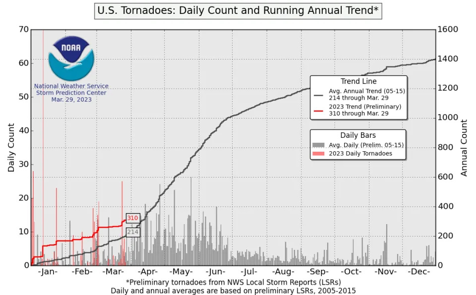
Even before the March 31 outbreak, tornado activity – at 311 tornadoes through March 29 – was already the third busiest start to the year since records began, according to data from the National Oceanic and Atmospheric Administration.

Combined with the preliminary total of 104 tornadoes during the devastating March 31 outbreak, the 415 tornadoes for the first quarter would be the busiest start to the year on record. The average through the end of April between 1991-2020 is 337.9.

Heartbreaking: Survivors describe deadly Missouri tornado

Destruction: 5 deaths reported after Missouri tornado

The U.S. had seen above normal tornado activity through the end of March, even before the March 31st tornado outbreak.
Why so much tornado activity?

A host of climate patterns and oceanic and atmospheric currents come together to create the conditions favorable for the supercell storms that spawn tornadoes.

“You really need to look at them all together holistically and understand that they all play together in an orchestra in a symphony, a very delicate symphony,” says Victor Gensini, an associate professor at Northern Illinois University.

What are the effects of climate change? Disasters, weather and agriculture impacts.

Heat and humidity help create the instability that spins up supercell storms, intense, long-lived thunderstorms with a rotating updraft. Supercells are responsible for tornadoes and hail and cause billions of dollars in losses and hundreds of casualties every year.

One essential ingredient is moisture, and the dial is cranked higher than normal in the Gulf of Mexico this year. Sea surface temperatures have been warmer than normal, thanks in part to a dearth of cold fronts and a persistent high pressure ridge in the region over the winter to help cool it down, said Gensini and others.

“We’re running anywhere from 2 to maybe 4 degrees Celsius warmer than average in the Gulf,” he said. When you have “bath water like this” and a southerly wind, it brings more moisture northward.

Combine that with the lingering effects of the La Nina and warm, dry winds from the west and it’s the recipe for an active period.

“I don’t really see this going away either,” Gensini said. “I think we will end up with an above average April.”

What do researchers know about climate change and tornadoes?

For more than a year, Professor Walker Ashley and his colleagues in the Department of Earth, Atmosphere and Environment at Northern Illinois, including Gensini and Assistant Professor Alex Haberlie, have been running models that simulate storm activity.

Their results suggest the potential by century’s end for more supercell storms, hail, extreme rainfall and significant tornadoes. And that could have “disastrous consequences,” said Ashley, the lead author.

  • They used two trajectories for potential greenhouse gas emissions, to see how that could influence the frequency or characteristics of tornado activity in the future.
  • Under either trajectory, the number of annual supercell storms becomes more frequent and intense, with the mean supercell activity increasing in the U.S. by 7-15%.
  • With increasing carbon dioxide emissions, the study projects an eastward shift in heightened supercell storm activity, particularly in the Ozarks and mid-South, with slight increases in the north and central regions of the Eastern U.S..
  • The simulations documented “diminished” storm activity in much of the Great Plains, west of the I-35 corridor.
  • Storm timing is expected to shift to earlier parts of the year, trailing off in the later months when temperatures climb in the summer.
Researchers at Northern Illinois University say rising greenhouse gas emissions may increase the number of supercell storms that increase tornadoes.
Are we seeing climate change impacts already in US tornadoes?

Possibly, but it’s not as obvious as a heat wave or extreme rainfall.

Although a multitude of factors enhance conditions and available energy for storms, it’s likely we are seeing a climate change signal in storm activity, Gensini said. Their projections, based on model simulations of the future, are consistent with changes already being seen in tornado frequency and location.

Tornado warning: Twisters hitting more frequently and dealing more deaths in the South

Tornado activity is expanding: Southern states see more twisters than ever

“The storms are more intense. They are longer-lived and they happen more frequently in the cool season,” he said. The distribution of tornadoes also is spreading out through the year, and decreasing in the summer when temperatures get really hot and wind shear decreases.

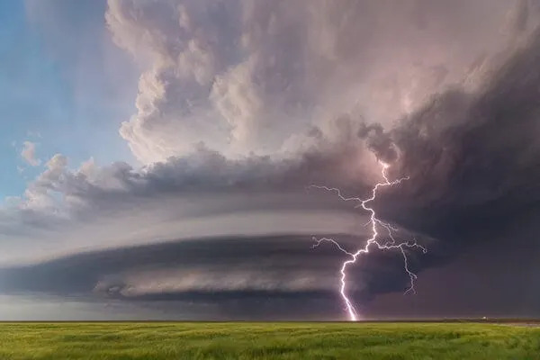
A June 2019 supercell over a field in Kansas.

Harold Brooks, a senior research scientist at the National Severe Storms Laboratory in Norman, Oklahoma, was a reviewer for the Northern Illinois study.

Its projected change in seasonal activity make sense, Brooks said. “If we make it warmer things should happen,” he said. It’s already been shown, for example, that fewer tornadoes occur when it’s really hot during the summer.

Ashley noted their research is still in its early stages.

One of the more concerning findings, he said, is that the cumulative footprint of the strongest supercells is projected to increase at the same time that communities are becoming more vulnerable because of expanding populations and development, which creates bigger target ares for storms.

Dinah Voyles Pulver covers climate and environment issues for USA TODAY.

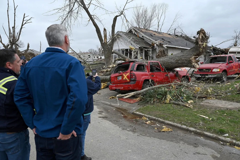
Sullivan Mayor Clint Lamb and Indiana Governor Eric Holcomb survey the damage caused by a tornado on Saturday, April 1, 2023 in Sullivan, Indiana.

Record snowfall buries California mountain town

ABC News

Record snowfall buries California mountain town

Phaedra Singelis – March 30, 2023

Major storm threatens to bring more tornadoes to hard-hit South

ABC News Chief Meteorologist Ginger Zee tracks the cross-country storm heading East as areas pummeled by the deadly tornado outbreak prepare for more severe weather.

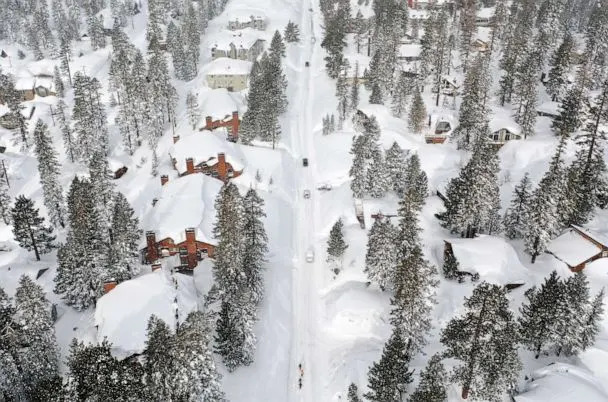
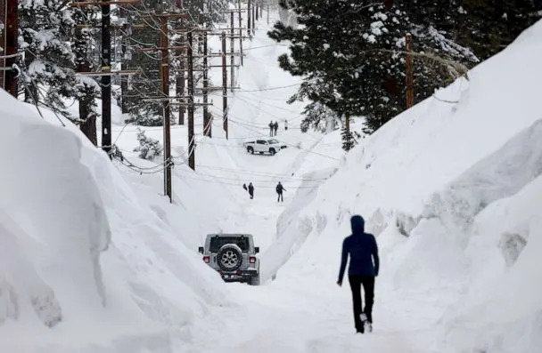
A series of mega-storms throughout March has brought snow to Mammoth Mountain in California’s Sierra Nevada Mountains, burying homes, cars and businesses.

PHOTO: Snowboarders walk and cars attempt to drive in the Sierra Nevada mountains, as now reached record levels, March 29, 2023 in Mammoth Lakes, Calif. (Mario Tama/Getty Images)
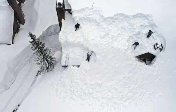
PHOTO: Workers remove snow from the roof of a condominium complex in the Sierra Nevada mountains, after yet another storm system brought heavy snowfall, March 29, 2023, in Mammoth Lakes, Calif. (Mario Tama/Getty Images)

Earlier this week, 20.7 inches fell in 24 hours at Mammoth Mountain, surpassing the all-time season snowfall record, according to the UC Berkeley Snow Lab, with more than 700 inches for the season. The previous record, set in the 2010-2011 season was 668 inches.

MORE: Cross-country storm to bring more severe weather, tornado threat

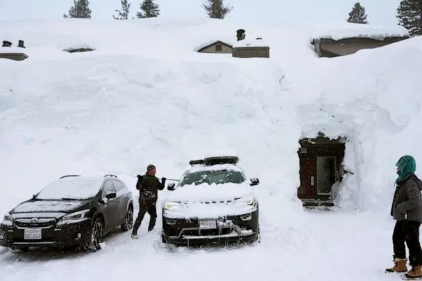
PHOTO: A person removes snow in front of lodging obscured by snowbanks piled up from new and past storms in the Sierra Nevada mountains, March 29, 2023, in Mammoth Lakes, Calif. (Mario Tama/Getty Images)
PHOTO: Snow blows in the Sierra Nevada mountains after yet another storm system brought heavy snowfall, March 29, 2023, in Mammoth Lakes, Calif. (Mario Tama/Getty Images)

People were out shoveling snow off roofs and trying to keep roads passable with windy conditions. Wind gusts at the ski resort were reported to be as high as 98 mph.

PHOTO: People make their way down a road is lined with snowbanks piled up from multiple storms, after more heavy snow fell, March 29, 2023, in Mammoth Lakes, Calif. (Mario Tama/Getty Images)
PHOTO: A skier passes by as workers remove snow from the roof of a condominium complex in the Sierra Nevada mountains after another storm system brought heavy snowfall, March 29, 2023, in Mammoth Lakes, Calif. (Mario Tama/Getty Images)

That will stretch the ski season through at least July at Mammoth Mountain ski resort, which has recorded 870 inches at the base of the Main Lodge.

SLIDESHOW: Storms bring epic rain and snow to California

Another 30 inches fell in the last 24 hours and the forecast is for snow this weekend and early next week.

PHOTO: Jeff Wright checks on his neighbor's home in the Sierra Nevada mountains, as snow piled up from new and past storms, March 29, 2023, in Mammoth Lakes, Calif. (Mario Tama/Getty Images)
PHOTO: Jeff Wright checks on his neighbor’s home in the Sierra Nevada mountains, as snow piled up from new and past storms, March 29, 2023, in Mammoth Lakes, Calif. (Mario Tama/Getty Images)
PHOTO: As night falls, a person shovels snow in the Sierra Nevada mountains, March 29, 2023 in Mammoth Lakes, Calif. (Mario Tama/Getty Images)

Record snowfall buries California mountain town originally appeared on abcnews.go.com

Lyme is not the only disease to worry about this tick season. What you need to know this spring.

Yahoo! News

Lyme is not the only disease to worry about this tick season. What you need to know this spring.

Cases of babesiosis — a tick-borne disease that can cause flulike symptoms — are on the rise in the Northeast, according to the CDC.

Laura Ramirez – Feldman, Reporter – March 30, 2023

A black-legged tick waving its front legs at the tip of a blade of vegetation.
The black-legged tick, otherwise known as the deer tick, can spread Lyme disease and babesiosis. (Reuters)

Spring is in full swing, and that means more sunlight, warmer temperatures and more time spent outdoors. It also means that for most of the United States, tick season has begun. Although tick exposure can occur year round, these insects are most active during the warmer months, starting in April.

Some states with greater tick activity have started to urge citizens to take precautions when enjoying the outdoors. Ticks carry several types of disease — Lyme disease being the most common — but health experts say Americans should be aware of a rise in other tick-borne illnesses in some regions of the country, including babesiosis.

What is babesiosis?

Babesiosis is a tick-borne disease caused by a parasite called Babesia microti and spread by the black-legged tick, otherwise known as the deer tick. In the U.S., the disease is more commonly found in the Northeast and Midwest, where deer ticks are abundant.

A bite from a tick carrying this parasite can infect red blood cells. While not everyone who is infected develops symptoms, some people can experience flulike symptoms such as fever, chills, muscle pain and fatigue.

Severe cases of babesiosis are rare, but the disease can be fatal for some people, particularly those who are immunocompromised, according to the Centers for Disease Control and Prevention. The agency also notes that the disease can lead to health complications, including acute respiratory distress and kidney failure.

Cases of babesiosis are increasing in the Northeast

This month, the CDC warned about a significant increase in tick-borne illnesses in the U.S. A study conducted by the agency found that U.S. tick-borne disease cases had risen by 25%, from 40,795 cases reported in 2011 to 50,856 in 2019. During the same period, “a total of 16,456 cases of babesiosis were reported to CDC by 37 states, including 16,174 (98.2%) reported from the 10 states included in this analysis,” the report noted.

Cases of babesiosis in particular climbed significantly in eight Northeastern states: Connecticut, Maine, Massachusetts, New Hampshire, New Jersey, New York, Rhode Island and Vermont.

Three New England states — Maine, New Hampshire and Vermont — saw the fastest growth in cases, which prompted the CDC to add them to the list of places where the disease is considered endemic (meaning it is consistently present).

“It’s certainly something that is of concern,” Griffin Dill, tick lab coordinator at the University of Maine Cooperative Extension, told Yahoo News. “It hasn’t reached the kind of case numbers that we’re seeing with Lyme disease or anaplasmosis quite yet, but it is certainly on the rise and something to be aware of.”

Although babesiosis cases are increasing, Lyme disease continues to be the most commonly reported tick-borne disease in the U.S., with approximately 35,000 cases reported to the CDC each year.

Dill and his team provide tick identification and testing services in Maine. By testing ticks that people bring to the lab, his team can identify the type of pathogens the insects could be carrying. Dill explained that this tool is an important one because it provides people with “a piece of risk information about the ticks on their property.” It also gives researchers a better understanding of the geographical spread of ticks and the diseases they carry.

The recent CDC report, Dill said, confirms what he’s been seeing in his lab.

“Just over the past five years that we’ve been doing this, we’ve seen an increase over time in the infection rate for Babesia,” he said. “So even just in a relatively short, five-year time frame, we’re seeing increases in the parasite within the tick itself, which then can correspond to increases in human cases as well.”

Experts believe that the actual number of cases is probably higher, because babesiosis is not reportable in all states. A main concern about the increased prevalence of the disease is that the parasite that causes it can be transmitted via blood transfusions. This, the CDC said, could pose a threat to the blood supply.

“Persons who acquire babesiosis through contaminated blood have been shown to have significantly worse health outcomes and a higher risk for death than do those who acquire the disease from a tick bite,” the agency said in the report.

However, government health agencies have already taken steps to protect the blood supply from the tick-borne disease. Since 2019, the Food and Drug Administration has recommended screening for the parasite at blood donation centers in 14 states and Washington, D.C., where the disease is more prevalent.

A collection of purple cells, one enlarged with a much darker purple blotch.
Blood sample showing the Babesia parasite. (Smith Collection/Gado/Getty Images)
Why are tick-borne diseases on the rise?

The CDC hasn’t explained why cases of babesiosis and other tick-borne diseases are up, but tick experts have a few theories as to why this may be happening.

Researchers say global warming is a contributing factor. Ticks thrive in warm and humid weather, usually anywhere there is lush greenery. As winters get warmer and shorter, the pests can stay active year round, causing more infections.

Dill said that seasonality patterns of black-legged ticks have almost disappeared.

“Normally, we get kind of a break in tick activity during the winter months, when it’s cold, it’s snowy, but with warmer weather [and] warmer temperatures, we can and do see them active year round, unfortunately,” he said.

The changes in climate and weather patterns have also had an impact on the geographic range of ticks. The habitat of black-legged ticks and other tick species is expanding, Dill explained.

“The black-legged tick, we’re certainly seeing them advance further and further north into northern New England and into Canada,” he said.

Another type of tick that has been on the move in the past two decades is the lone star tick. These ticks can spread an unusual disease called alpha-gal syndrome, which causes an allergic reaction to mammal meats such as beef, pork and lamb. They were historically found in the Southern U.S., but Stephen Rich, director of the New England Center of Excellence in Vector-Borne Diseases, said they are moving north, and farther inland. Their population is also growing.

“There are spots like Long Island, N.Y., where basically the lone star ticks have almost replaced the ticks that transmit Lyme disease — the black-legged ticks. So they’re definitely moving northward,” he said.

Both Dill and Rich said climate change is not the only reason why ticks and tick-borne diseases have spread throughout the country.

“We can’t say that it’s not global warming. But the stronger evidence is that this has to do with the way we manage our landscapes,” Rich said.

The way we like to see our properties, with stone walls and lawns with wooded edges, turns out to be perfect for deer and for deer ticks or black-legged ticks. “We’ve cultivated landscapes that are perfect for ticks and tick-borne diseases,” he added.

A live specimen of the lone star tick (A. Americanum) in a lab in Morrill Hall at the University of Illinois at Urbana-Champaign in 2017.
The lone star tick gets its name from the single, silvery-white spot on the female’s back. (Brian Cassella/Chicago Tribune/Tribune News Service via Getty Images)
How to prevent tick-borne disease

The best way to protect yourself from babesiosis and other tick-borne illnesses is to avoid getting bitten by a tick.

These critters live in grassy, brushy and wooded areas, so you are more likely to have encounters with them when going outside to garden, walk your dog or go camping or hiking.

To prevent tick bites, Dill recommends that people create a layer of protection.

“That barrier can be something as simple as just wearing protective clothing, so wearing long pants and tucking those pants into your boots or into your socks, just anything that’s going to prevent a tick from actually getting to your skin,” he said.

Using repellents is also a good option. Certain repellents are designed to be used on clothing; others can be applied directly to the skin. The CDC recommends using Environmental Protection Agency-registered insect repellents. If you are not sure which product to use, the EPA has a search tool that can help find the best fit for you.

Checking your body for ticks after spending time outdoors is also highly recommended.

“Just make it a routine to look over your body and see if you have ticks,” Rich said, adding that people should check their children and pets as well.

Finally, if you do find a tick on yourself, the experts said there’s no reason to panic, because not every tick is carrying a disease. If the insect has bitten you, the CDC recommends removing it with fine-tipped tweezers and cleaning the bite area with rubbing alcohol or with soap and water.

Rich told Yahoo News that people should also consider saving or photographing the tick so a professional can evaluate it and determine if it is carrying harmful bacteria. He recommended the University of Rhode Island’s TickSpotters program, which offers free tick identification service, as one place where this can be done.

If you develop a rash or fever after getting bitten by a tick, the CDC recommends that you consult a medical professional.

“I think awareness is kind of the key there,” Dill said. “We don’t want people to be afraid of these illnesses and … prevent people from going outdoors and enjoying outdoor activities. But be aware and take some precautions when recreating outside.”

DeSantis has one thing in common with trump, they do nothing constructive: No One Is Talking About What Ron DeSantis Has Actually Done to Florida

Time

No One Is Talking About What Ron DeSantis Has Actually Done to Florida

William Kleinknecht – March 29, 2023

Florida Governor DeSantis Kicks Off His "Freedom Blueprint" Tour In Florida
Florida Governor DeSantis Kicks Off His “Freedom Blueprint” Tour In Florida

Florida Gov. Ron DeSantis speaks during an event spotlighting his newly released book, ‘The Courage To Be Free: Florida’s Blueprint For America’s Revival at the Orange County Choppers Road House & Museum on March 08, 2023 in Pinellas Park, Fl. Credit – Joe Raedle—Getty Images

Media coverage of Florida Gov. Ron DeSantis’s all-but-announced candidacy for president is already in full frenzy, and so far the script is exactly as his handlers would like it to be. The governor regularly opens up new fronts in the culture wars, sowing alarm over critical race theory, transgender rights, or border policies. In response, liberal pundits fall into the trap of accentuating the very issues DeSantis has chosen to fire up his base.

Omitted from the public debate about DeSantis’s policies is almost any discussion of his actual record of governance—what exactly he has delivered to the citizens of his state, especially those without seven-figure incomes and lush investment portfolios.

Even a cursory dip into the statistics of social and economic well-being reveals that Florida falls short in almost any measure that matters to the lives of its citizens. More than four years into the DeSantis governorship, Florida continues to languish toward the bottom of state rankings assessing the quality of health careschool fundinglong-term elder care, and other areas key to a successful society.

Florida may be the place where “woke goes to die”—as DeSantis is fond of saying—but it is also where teachers’ salaries are among the lowest in the nation, unemployment benefits are stingier than in any other state, and wage theft flourishes with little interference from the DeSantis administration. In 2021, DeSantis campaigned against a successful ballot initiative to raise the state’s minimum wage, which had been stuck at $8.65 an hour. Under DeSantis’s watch, the Sunshine State has not exactly been a workers’ paradise.

Read More: Why “Woke” Is A Convenient Republican Dog Whistle

DeSantis weaponizes the cultural wars to distract attention from the core missions of his governorship, which is to starve programs geared toward bettering the lives of ordinary citizens so he can maintain low taxes on the wealthy and corporations. Florida is the ideal haven for privileged Americans who don’t want to pay their fair share of taxes. It has no income tax for individuals, and its corporate tax rate of 5.5% is among the lowest in the nation. An investigation by the Orlando Sentinel in late 2019 revealed the startling fact that 99% of Florida’s companies paid no corporate income tax, abetted by tax-avoidance schemes and state officials who gave a low priority to enforcing tax laws.

This is a pattern that shows up in the statistics of many Republican-led states, which on average commit fewer dollars per-capita to health carepublic education, and other crucial services compared to their blue counterparts, while making sure corporations and wealthy individuals are prioritized for tax relief. Arizona cut taxes every year between 1990 and 2019, following up with a shift to a flat tax this year that will cost its budget $1.9 billion. Meanwhile, its public-school spending ranks 48 among the 50 states.

In Florida, the state’s tax revenues come largely through sales and excise taxes, which fall hardest on the poor and middle class. A 2018 study by the left-leaning Institute on Taxation and Economic Policy found that Florida had the third least-equitable tax system of the 50 states. In the state’s “upside-down” tax structure, the poorest 20% of Florida families paid 12.7% of their income in taxes, while the families whose income was in the top 4% paid 4.5%, and the top 1% paid 2.3%, according to the study.

Florida taxpayers get less for their money than residents of many other states. The Commonwealth Fund, a private foundation that studies health-care systems globally, found in its 2022 “scorecard” that Florida had the 16th worst health care among the 50 states. It’s no wonder that Florida ranks below the northern blue states in life expectancy and rates of cancer deathdiabetesfatal overdosesteen birth rates, and infant mortality.

Largely because of DeSantis’s obstinacy, Florida is one of 10 states that have refused to expand Medicaid under the Affordable Care Act, an act of political spite that has cost those states billions in federal health care dollars and cost thousands of people their lives. More than 12% of Floridians are without medical insurance, a worse record than all but four other states. Despite having the country’s highest percentage of retirees, Florida has the worst long-term care among the 50 states, according to the American Association of Retired Persons.

Public schools fare no better than health care in DeSantis’s Florida. Not only did Florida rank 49th in the country for average teacher pay in 2020, but the Education Law Center, a non-profit advocacy group based in New Jersey, found in a 2021 report that the state had the seventh-lowest per-pupil funding in the country. Education Week, which ranks states public school annually, looking beyond mere test scores, placed Florida 23rd in its 2021 report, a lackluster showing for a large and wealthy state.

It says something about the state of our political discourse that Florida’s denuded public sector was not more of an issue in last year’s gubernatorial campaign. In endorsing DeSantis’s Democratic opponent, Charlie Crist, the Tampa Bay Times spent so many column inches on the incumbent’s demagoguery, vindictiveness, and authoritarian tendencies that it never even got to the minutiae of his governance. “No matter what you think about the state of the Florida economy or its schools or its future…,” the paper wrote, “the choice really is this simple: Do you want the state governed by a decent man or a bully?”

To be fair to the media, DeSantis and his allies manned the trenches of the culture wars so ferociously that it was all reporters could do to keep up with all the bomb throwing. How do you delve into the state’s tax policy when your governor is flying planeloads of migrants to Martha’s Vineyard or declaring war on Disney for issuing a statement in opposition to the state’s so-called “Don’t Say Gay Law”?

But that is very much the point of wedge issues, as they have been wielded by scurrilous politicians for decades, to anger and distract voters so they won’t notice the actions of public officials that mainly benefit the wealthy and are against the public interest.

As the 2024 election draws closer, DeSantis must not be allowed to accomplish nationally what he did in his state—cloak his service to the wealthy by frightening working people with stories about transgender recruiting and “socialist” college professors. There are unmistakable signs that Americans are focused on what an activist government can do for the public good, as evidenced by Floridians’ vote to increase the minimum wage.

The failure of DeSantis to better serve the most vulnerable citizens of his state is his weak underbelly in a national campaign.