Texas oil pipelines face dry months as production languishes
Devika Krishna Kumar April 13, 2021
NEW YORK (Reuters) -Nearly half of all oil pipelines from the Permian basin, the biggest U.S. oilfield, are expected to be empty by the end of the year, analysts and executives said.
Pipeline companies went on a construction spree throughout 2018 and 2019 to handle blistering growth in U.S. crude production to a record 13 million barrels per day (bpd). However, the coronavirus pandemic crushed both fuel demand and oil production, and neither have recovered fully, leaving many pipelines unused.
Major pipeline companies are exploring ways to ship other products in those lines and considering selling stakes in operations to raise cash.
The coronavirus pandemic upended the global energy supply system and worldwide fuel demand. U.S. gasoline consumption is now estimated to be past its peak and as refiners process less crude, producers are not filling pipelines used to transport it.
By the fourth quarter, total utilization of the largest oil pipelines from the Permian is expected to drop to 57%, consultancy Wood Mackenzie said. The nadir during the last market bust in 2016 was roughly 70%.
U.S. crude output is currently about 11 million bpd, and is not expected to grow much until 2022. But more pipelines were already set to come online, growing the gap between production and capacity covered by long-term contracts to a record over 1 million bpd in February, according to energy research firm East Daley Capital.
“We do not expect to be at pre-COVID production levels by end-2022,” said Saad Rahim, chief economist at commodities merchant Trafigura.
REVENUES HIT
The top three Permian pipeline companies are offering discounts to entice shippers and stem the fall in volumes. Companies rely on long-term contracts that require customers to ship a certain volume of oil or pay a penalty. Now companies are renegotiating those agreements at lower rates when they are close to expiring, to keep their customers.
Magellan Midstream Partners LP’s transportation and terminals revenue slid 9% to about $1.8 billion in 2020, the lowest since 2017. The company has only enough long-term contracts to fill its 275,000-bpd Longhorn pipeline to 70% capacity over the next six years, Magellan said.
With more pipelines adding to competition, Magellan expects daily volumes on Longhorn to drop to an average 230,000 bpd this year versus 270,000 bpd in 2020. A Magellan spokesman said the company could use its marketing arm to buy space on the Longhorn line and sell it to ad-hoc buyers.
Plains All American Pipeline LP’s transportation revenues fell about 13% to $2 billion in 2020, and warned that earnings could suffer further if production declines. Plains did not comment for this story.
Pipeline companies can make some money even when oil is not flowing through pipelines. Producers pay what are known as deficiency payments – penalties for not shipping oil. Still, those payments are small. Plains reported $71 million in deficiency payments in 2020, less than 4% of its overall transportation segment revenue.
Some companies are considering retrofitting pipelines to ship liquids besides crude, such as renewable fuels.
Enterprise Products Partners LP’s co-Chief Executive Jim Teague recently told analysts that he was fielding queries from a petrochemical company that needs pipeline transport and storage for potential hydrogen projects.
Enterprise’s crude pipelines and services revenues plunged 35% in 2020. In February, it said it has long-term contracts to ship about 1 million bpd through 2028 and beyond, compared with average volumes of 2 to 2.2 million bpd over the past two years.
The company did not comment for this story.
As pipeline companies have struggled, investor returns have suffered. The Alerian MLP index, which tracks the performance of midstream companies, is down 24% since the beginning of 2020, compared with a 27% return for the S&P 500.
“A lot of companies had to cut their dividends,” said Rob Thummel, senior portfolio manager at TortoiseEcofin. “It has created some skepticism on the investor base about the sustainability of the sector.”
(Reporting by Devika Krishna Kumar in New York; additional reporting by David FrenchEditing by Marguerita Choy)
Nervous North American farmers set to ‘seed in faith’ into parched soils
Rod Nickel and Julie Ingwersen April 12, 2021
FILE PHOTO: Hay bales rest in a field in Killdeer, North Dakota
WINNIPEG, Manitoba/CHICAGO (Reuters) – Fields across the Canadian Prairies and the U.S. Northern Plains are among the driest on record, raising production risks in one of the world’s key growing regions for canola and spring wheat.
As planting season begins, the dusty soils generate fears that seeds will fail to germinate or yield smaller crops in a year when demand for canola already far outstrips supply. Unusually strong wheat exports to China for animal feed have also lowered global supplies of the main ingredient in bread and pasta.
Prices of canola, which is processed into vegetable oil and animal feed, hit all-time highs in February and Canadian supplies look to dwindle by midsummer to an eight-year low.
Spring wheat futures are trading near their highest levels since 2017, the last time significant drought gripped the northern U.S. Plains.
“I guess we seed in faith, hoping it’s going to rain,” said Steven Donald, 41, a fourth-generation member of a family-owned grain and cattle farm near Moosomin, Saskatchewan. “It’s the driest that we can remember.”
Donald’s fields are powder-dry. His pastures crunch under his boots and contain gaping cracks.
In eastern Saskatchewan and Manitoba, a dry winter followed scant rainfall during the last growing season, said Bruce Burnett, director of markets and weather at Glacier FarmMedia.
Much of western Manitoba had the driest or close to the driest winter in more than a century of records, according to Agriculture and Agri-Food Canada data. Most of arable Manitoba and southern Saskatchewan faces severe to extreme drought, the federal department said on Friday.
Many farmers are adjusting by scaling back canola plantings, said Neil Townsend, FarmLink Marketing Solutions’ chief market analyst, citing surveys. Canola is especially vulnerable to drought that can prevent seeds from germinating.
RECORD-BREAKING DRYNESS IN NORTH DAKOTA
Across the border in North Dakota, the top U.S. spring wheat producer, the last six months have been the driest in records dating to 1895, said Adnan Akyuz, the state’s official climatologist. The latest weekly U.S. Drought Monitor showed 70% of North Dakota in “extreme drought,” up from 47% the previous week.
The Drought Monitor shows a better outlook for corn and soybeans, the main U.S. cash crops, mostly grown farther south.
Rain and snow are expected in North Dakota this week, according to meteorologist Greg Gust with the National Oceanic and Atmospheric Administration.
But it is unlikely to amount to much relief, although showers are possible in the 16-30-day period, said Joel Widenor, agriculture meteorologist with the Commodity Weather Group. Most of the state’s wheat crop is planted in late April and May.
Statistics Canada will issue its first report on planting intentions on April 27. Farmers are likely to seed 4% more canola, mainly in northern areas with more soil moisture, Agriculture Canada said on March 18.
The U.S. Department of Agriculture last month projected that North Dakota farmers would plant 7 million acres of soybeans, making it the state’s most-planted crop, while spring wheat acres would fall 2% to 5.6 million.
Soil erosion is a concern as winds whip the region, said Jim Peterson of the North Dakota Wheat Commission. As a result, wheat may lose more acres to soybeans, which farmers can plant into June without stirring up fields to apply fertilizer, he said.
Conditions are the driest that Minto, Manitoba, farmer Jake Ayre and his family have seen since emigrating to Canada from England in 2002. But most planting in the region, known for its volatile weather, occurs in May.
“We’re not panicking,” Ayre said. “My dad said, ‘We’re always three weeks away from a drought, three weeks away from a flood.'”
(Reporting by Rod Nickel in Winnipeg and Julie Ingwersen in Chicago; Editing by Matthew Lewis)
‘No community should suffer this’: Florida’s toxic breach was decades in the making
Paola Rosa-Aquino April 11, 2021
It’s been a week since a significant leak at a long-abandoned fertilizer plant in the Tampa Bay area threatened the surrounding groundwater, soil, and local water supplies.
Last weekend, officials ordered more than 300 families living near the 676-acre Piney Point plant site in Manatee county to evacuate. The sheriff even emptied out his jail’s first floor of inmates in case a “20-foot wall of water” came rolling their way.
By Monday, local officials said they thought the crisis had been averted; they lifted evacuation orders on Tuesday afternoon. But what they meant was that imminent catastrophe had been postponed. The long-term, slow-moving crisis of toxicity, decades in the making, remains – and is echoed at dozens of radioactive ponds across the state.
“We’re nowhere near out of the woods yet on this – there’s a long way to go,” says Glen Compton of ManaSota-88, an environmental non-profit that has been urging officials for decades to do something about the industrial waste pile.
Piney Point has a long history of polluting the water and air around it, dating to when the plant was built in 1966, Compton says. Just two years later, in 1968, Compton founded ManaSota-88 to oppose the site’s phosphate mining. (“The 88 stood for 1988 because we were supposed to solve all the problems within 20 years,” Compton says. “So now, the 88 stands for 2088.”)
Effluent spews from a pipe into a ditch at Port Manatee, where a breach in a nearby wastewater reservoir on the site of a defunct phosphate plant forced an evacuation order.Photograph: Octavio Jones/Reuters
Within a year of Piney Point being built, its original owners – a subsidiary of Borden, the glue and milk company – were caught dumping waste into nearby Bishop Harbor, a marine estuary that flows into Tampa Bay. The plant repeatedly changed hands throughout the years, all the while continuing causing numerous human health and environmental disasters and incidents.
In 1989, for instance, a 23,000-gallon leak of sulfuric acid from a holding tank forced the evacuation of hundreds of people.
After the owner went bankrupt, the Piney Point fertilizer plant was shut down in 2001. But the waste from more than three decades of phosphate mining still sits in massive piles at the site – the environmental equivalent of a ticking time bomb. An intense storm could easily send overflow, for instance.
Before phosphate can be used to help crops grow in fertilizer, it goes through a polluting chemical process. Phosphate ore mined from the soil is treated to create phosphoric acid – a main component of fertilizer. Phosphogypsum is the radioactive waste left over. For every ton of desirable phosphoric acid produced for fertilizer, more than five tons of phosphogypsum waste remains.
The fertilizer industry that produced that waste then dumps it in large piles known as “gyp stacks” – mountains hundreds of feet tall and hundreds of acres wide. And at the top of these mountains are huge lagoons, containing hundreds of millions of gallons of wastewater that is highly acidic and radioactive with heavy metal contaminants. A breach at another stack in the state after a 2004 hurricane led to millions of gallons of polluted water being spilled into Tampa Bay.
This toxic industry has plagued the state for decades. Central Florida is the phosphate capital of the world; the state produces 80% of the phosphate mined in the US, as well 25% of the phosphate used around the world. An estimated 1 billion tons of phosphogypsum is housed in about two dozen stacks that dot the Florida landscape, some looming as high as 200ft, each with its own pond of acidic wastewater on top. And every year, about 30m more tons are added to them.
“Florida can’t keep ignoring the catastrophic risks of phosphate mining and its toxic waste products,” says Jaclyn Lopez, Florida director at the Center for Biological Diversity. “No community should have to suffer the consequence of this toxic legacy for some corporation’s short-term financial gain.”
According to Compton, what happens at Piney Point sets a precedent in Florida regarding industrial waste from phosphate mining. “Everything that can go wrong has gone wrong here,” he says.
About 223 million gallons remained in the leaking pond at Piney Point on Friday, according to the Florida department of environmental regulation; so far, about 215m gallons of wastewater have been pumped into Tampa Bay. Still, environmental advocates fear how the plant’s toxic stew might affect water quality: on Wednesday, the state agency said there were elevated levels of phosphorous detected where wastewater was being discharged.
Two additional stacks with wastewater containment ponds remain at Piney Point, and officials fear an unaddressed breach could lead to a sudden rush of water out of the other two stacks, which are more toxic and acidic. If that were to happen, Compton says, “we’d expect to see major impacts to Bishop Harbor, which is one of the prettiest places in the state of Florida”.
Should either of those stacks fail, he adds, the harbor “would be totally annihilated. It is really not too strong a term to use.” The nutrient-laden water could fuel algae blooms, endangering already vulnerable marine life.
At the end of Wednesday, with pumps still gushing out millions of gallons of wastewater, state senators passed an amendment that would allocate $3 million – what appears to be the first tranche of funds in a $200m plan to close and clean up the site – to dispose of the wastewater.
Compton says the plan entails building a well injection in order to get rid of the wastewater – an idea facing opposition from surrounding residents, national organizations, and anybody who has an interest in agriculture in the area. “When you put wastewater into the ground, you really have no idea where it goes next. There’s no 100% foolproof way to monitor which way the aquifer flows and where it ultimately ends up.”
The Piney Point site is shaping up to be a costly environmental catastrophe, and Compton thinks the fertilizer industry should be accountable for disposing of its waste, rather than passing the cost on to taxpayers. But even with talks of the fertilizer plant’s cleanup and closure on the horizon, he’s not optimistic the threat of pollution from its wastewater will soon disappear.
“There’s a local saying that if you go to a Manatee county commission meeting 50 years from now, there’s two things that’ll be on the agenda: sewage spills and Piney Point,” Compton adds. “This isn’t going away anytime soon.”
Western U.S. may be entering worst drought in modern history
Jeff Berardelli April 11, 2021
Western U.S. may be entering worst drought in modern history.
Extreme drought across the Western U.S. has become as reliable as a summer afternoon thunderstorm in Florida. And news headlines about drought in the West can seem a bit like a broken record, with some scientists saying the region is on the precipice of permanent drought.
That’s because in 2000, the Western U.S. entered the beginning of what scientists call a megadrought — the second worst in 1,200 years — triggered by a combination of a natural dry cycle and human-caused climate change.
In the past 20 years, the two worst stretches of drought came in 2003 and 2013 — but what is happening right now appears to be the beginning stages of something even more severe. And as we head into the summer dry season, the stage is set for an escalation of extreme dry conditions, with widespread water restrictions expected and yet another dangerous fire season ahead.
/ Credit: NOAA
The above image is a time series of drought in the western states from 2000 to 2021. This latest 2020-2021 spike (on the right) is every bit as impressive as the others, but with one notable difference — this time around, the area of “exceptional drought” is far larger than any other spike, with an aerial coverage of over 20%. As we enter the dry season, there is very little chance conditions will get better — in fact it will likely only get drier.
With this in mind, there is little doubt that the drought in the West, especially the Southwest, this summer and fall will be the most intense in recent memory. The only real question: Will it last as long as the last extended period of drought from 2012 to 2017? Only time will tell.
Right now, the U.S. Drought Monitor places 60% of the Western states under severe, extreme or exceptional drought. The reason for the extensive drought is two-fold; long term drying fueled by human-caused climate change and, in the short term, a La Niña event in which cool Equatorial Pacific waters failed to fuel an ample fetch of moisture.
/ Credit: CBS News
Consequently, this past winter’s wet season was not very wet at all. In fact, it just added insult to injury, with only 25 to 50% of normal rainfall falling across much of the Southwest and California. This followed one of the driest and hottest summers in modern times, with two historic heat waves, a summer monsoon cycle that simply did not even show up and the worst fire season in modern times.
The image below shows what is called the precipitation percentile from October through March, comparing this past six months to the same six-month stretch in each of the past 50 years.
/ Credit: ClimateToolbox.org
The light brown shading shows areas in which the most recent six-month stretch was in the driest 10% of the last 50 years. The dark brown shade indicates the areas which experienced their lowest precipitation on record during this latest six-month span. Almost all areas are covered by one of those two shades.
Kelsey Satalino, the Digital Communications Coordinator from NOAA’s National Integrated Drought Information System, says that during the past few months, several states including Nevada, Arizona, New Mexico and Utah experienced their most intense period of drought since the Drought Monitor began back in 2000. As a result, soil moisture content is at its lowest levels in at least 120 years.
The Pacific Northwest, however, is faring much different this season. The northern half of the West experienced normal to even above normal snowfall this winter, on par with what is expected during a typical La Niña event featuring a further north jet stream storm track. That good fortune did not extend further south, however, with most areas now at only 50 to 75% of normal snowpack.
/ Credit: SNOTEL
Since the West relies on melting snowpack to fill lakes, reservoirs and rivers, like the Colorado, water availability will be limited this summer. The Colorado River and its tributaries provide water for around 40 million people and 5 million acres of farmland. The amount of water flowing into Lake Powell, on the Arizona-Utah state line, in the coming months is only expected to be around 45% of the typical amount. Lake Meade, on the Arizona-Nevada state line, is only at 40% capacity.
But this lack of snowpack is not a one-time issue; it is a trend. Over the past 40 years, snowpack has declined by about 25% over the Western states. Meanwhile, the population continues to increase. Thus, as of late, water demand has been outstripping what mother nature can deliver.
/ Credit: Climate Central
In general, these water woes are not expected to improve. While there will be wet years, the overall trend is towards drying. Scientists say this is a result of human-caused climate change, which is leading to less reliable rain and warmer temperatures — both consistent with what has been projected by climate computer models. The image below shows a clear trend toward worsening drought since 1900.
/ Credit: Climate Central
New research from the U.S. Department of Agriculture shows that over the past several decades, precipitation has become more erratic and dry periods between rain storms have expanded. Even if rain or snow falls heavier, that’s less important than consistency. Soil moisture and vegetation thrive on precipitation that is spread out more evenly over time, rather than heavy events which tend to run-off, resulting in wasted moisture.
At the same time, temperatures across the Western U.S. have increased by a few degrees over the past 50 years. The warmer air provides more heat energy to evaporate moisture from vegetation and soil. As a result, the ground continues to dry out, providing flammable fuel for escalating fire seasons.
In fact, 2020 was the worst fire season in the modern history of the West, with California and Colorado experiencing their largest fires on record. As can be seen in the below visual, the intensity of fires and acres burned tracks with increasing temperatures. Simply put, the warmer and drier it gets, the larger fires become.
/ Credit: CBS News
Because of a warming climate, fire season in the West is now two to three months longer than it was just a few decades ago. That means, with the dry season already getting underway in the West, the time to prepare for wildfires is fast approaching.
Scientists Warn 4°C World Would Unleash ‘Unimaginable Amounts of Water’ as Ice Shelves Collapse
By Jessica Corbett, Common Dreams April 11, 2021
Pexels
A new study is shedding light on just how much ice could be lost around Antarctica if the international community fails to urgently rein in planet-heating emissions, bolstering arguments for bolder climate policies.
The study, published Thursday in the journal Geophysical Research Letters, found that over a third of the area of all Antarctic ice shelves — including 67% of area on the Antarctic Peninsula — could be at risk of collapsing if global temperatures soar to 4°C above pre-industrial levels.
An ice shelf, as NASA explains, “is a thick, floating slab of ice that forms where a glacier or ice flows down a coastline.” They are found only in Antarctica, Greenland, Canada, and the Russian Arctic—and play a key role in limiting sea level rise.
“Ice shelves are important buffers preventing glaciers on land from flowing freely into the ocean and contributing to sea level rise,” explained Ella Gilbert, the study’s lead author, in a statement. “When they collapse, it’s like a giant cork being removed from a bottle, allowing unimaginable amounts of water from glaciers to pour into the sea.”
“We know that when melted ice accumulates on the surface of ice shelves, it can make them fracture and collapse spectacularly,” added Gilbert, a research scientist at the University of Reading. “Previous research has given us the bigger picture in terms of predicting Antarctic ice shelf decline, but our new study uses the latest modelling techniques to fill in the finer detail and provide more precise projections.”
Gilbert and co-author Christoph Kittel of Belgium’s University of Liège conclude that limiting global temperature rise to 2°C rather than 4°C would cut the area at risk in half.
“At 1.5°C, just 14% of Antarctica’s ice shelf area would be at risk,” Gilbert noted in The Conversation.
While the 2015 Paris climate agreement aims to keep temperature rise “well below” 2°C, with a more ambitious 1.5°C target, current emissions reduction plans are dramatically out of line with both goals, according to a United Nations analysis.
Gilbert said Thursday that the findings of their new study “highlight the importance of limiting global temperature increases as set out in the Paris agreement if we are to avoid the worst consequences of climate change, including sea level rise.”
“If temperatures continue to rise at current rates,” she said, “we may lose more Antarctic ice shelves in the coming decades.”
The researchers warn that Larsen C—the largest remaining ice shelf on the Antarctic peninsula—as well as the Shackleton, Pine Island, and Wilkins ice shelves are most at risk under 4°C of warming because of their geography and runoff predictions.
“Limiting warming will not just be good for Antarctica—preserving ice shelves means less global sea level rise, and that’s good for us all,” Gilbert added.
Low-lying coastal areas such as small island nations of Vanuatu and Tuvalu in the South Pacific Ocean face the greatest risk from sea level rise, Gilbert toldCNN.
“However, coastal areas all over the world would be vulnerable,” she warned, “and countries with fewer resources available to mitigate and adapt to sea level rise will see worse consequences.”
A co-author of that study, John Church of the Climate Change Research Center at the University of New South Wales, said at the time that “if we continue with large ongoing emissions as we are at present, we will commit the world to meters of sea level rise over coming centuries.”
Parties to the Paris agreement are in the process of updating their emissions reduction commitments—called nationally determined contributions—ahead of November’s United Nations climate summit, known as COP26.
Sea level rise is killing trees along the Atlantic coast, creating ‘ghost forests’ that are visible from space
Emily Ury, Ph.D. Candidate, Duke University April 6, 2021
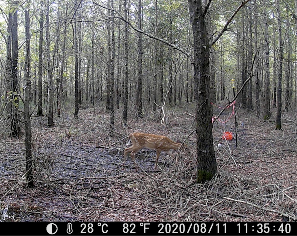
Ghost forest panorama in coastal North Carolina.Emily Ury, CC BY-ND
Trekking out to my research sites near North Carolina’s Alligator River National Wildlife Refuge, I slog through knee-deep water on a section of trail that is completely submerged. Permanent flooding has become commonplace on this low-lying peninsula, nestled behind North Carolina’s Outer Banks. The trees growing in the water are small and stunted. Many are dead.
Throughout coastal North Carolina, evidence of forest die-off is everywhere. Nearly every roadside ditch I pass while driving around the region is lined with dead or dying trees.
As an ecologist studying wetland response to sea level rise, I know this flooding is evidence that climate change is altering landscapes along the Atlantic coast. It’s emblematic of environmental changes that also threaten wildlife, ecosystems, and local farms and forestry businesses.
Like all living organisms, trees die. But what is happening here is not normal. Large patches of trees are dying simultaneously, and saplings aren’t growing to take their place. And it’s not just a local issue: Seawater is raising salt levels in coastal woodlands along the entire Atlantic Coastal Plain, from Maine to Florida. Huge swaths of contiguous forest are dying. They’re now known in the scientific community as “ghost forests.”
The insidious role of salt
Sea level rise driven by climate change is making wetlands wetter in many parts of the world. It’s also making them saltier.
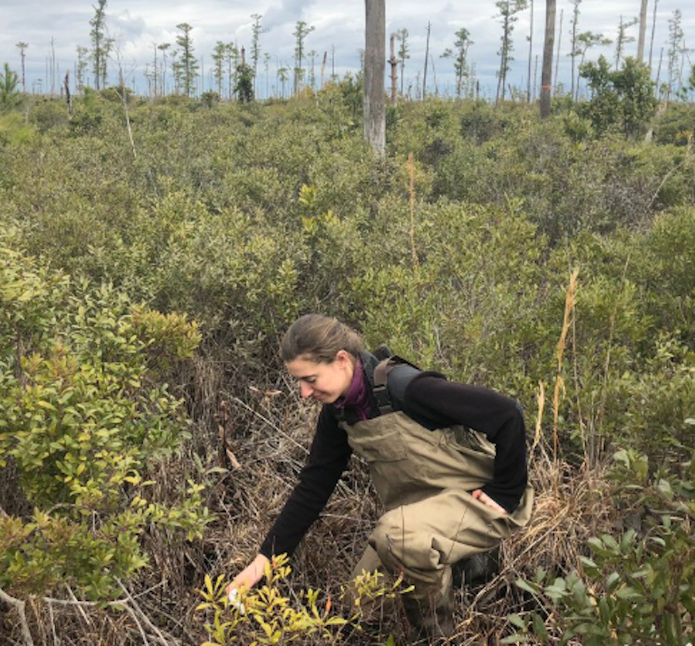
In 2016 I began working in a forested North Carolina wetland to study the effect of salt on its plants and soils. Every couple of months, I suit up in heavy rubber waders and a mesh shirt for protection from biting insects, and haul over 100 pounds of salt and other equipment out along the flooded trail to my research site. We are salting an area about the size of a tennis court, seeking to mimic the effects of sea level rise.
After two years of effort, the salt didn’t seem to be affecting the plants or soil processes that we were monitoring. I realized that instead of waiting around for our experimental salt to slowly kill these trees, the question I needed to answer was how many trees had already died, and how much more wetland area was vulnerable. To find answers, I had to go to sites where the trees were already dead.
Rising seas are inundating North Carolina’s coast, and saltwater is seeping into wetland soils. Salts move through groundwater during phases when freshwater is depleted, such as during droughts. Saltwater also moves through canals and ditches, penetrating inland with help from wind and high tides. Dead trees with pale trunks, devoid of leaves and limbs, are a telltale sign of high salt levels in the soil. A 2019 report called them “wooden tombstones.”
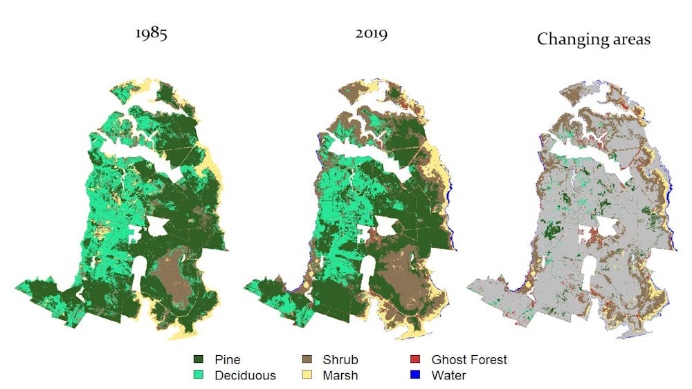
As the trees die, more salt-tolerant shrubs and grasses move in to take their place. In a newly published study that I coauthored with Emily Bernhardt and Justin Wright at Duke University and Xi Yang at the University of Virginia, we show that in North Carolina this shift has been dramatic.
To understand where and how quickly these forests are changing, I needed a bird’s-eye perspective. This perspective comes from satellites like NASA’s Earth Observing System, which are important sources of scientific and environmental data.
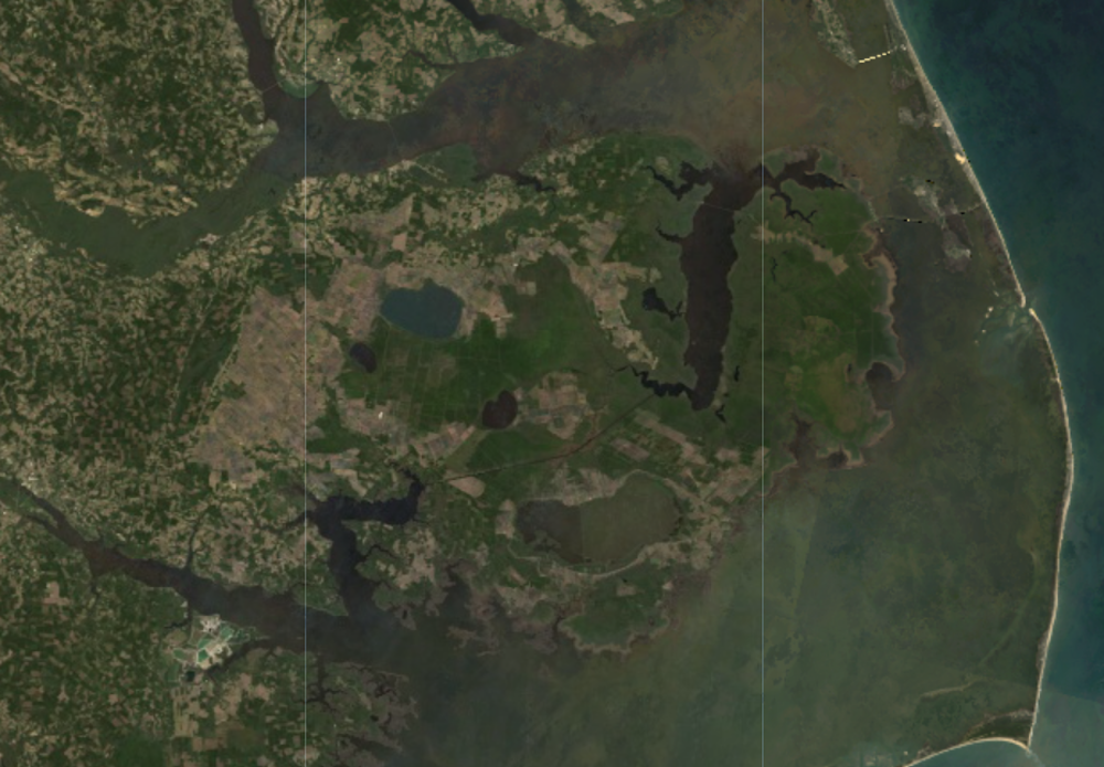
Satellite image of coastal North Carolina
Since 1972, Landsat satellites, jointly operated by NASA and the U.S. Geological Survey, have captured continuous images of Earth’s land surface that reveal both natural and human-induced change. We used Landsat images to quantify changes in coastal vegetation since 1984 and referenced high-resolution Google Earth images to spot ghost forests. Computer analysis helped identify similar patches of dead trees across the entire landscape.
Google Earth image with road dividing healthy and dead forests.
The results were shocking. We found that more than 10% of forested wetland within the Alligator River National Wildlife Refuge was lost over the past 35 years. This is federally protected land, with no other human activity that could be killing off the forest.
Rapid sea level rise seems to be outpacing the ability of these forests to adapt to wetter, saltier conditions. Extreme weather events, fueled by climate change, are causing further damage from heavy storms, more frequent hurricanes and drought.
We found that the largest annual loss of forest cover within our study area occurred in 2012, following a period of extreme drought, forest fires and storm surges from Hurricane Irene in August 2011. This triple whammy seemed to have been a tipping point that caused mass tree die-offs across the region.
Salt water intrusion is rapidly killing North Carolina coastal forests.
Should scientists fight the transition or assist it?
As global sea levels continue to rise, coastal woodlands from the Gulf of Mexico to the Chesapeake Bay and elsewhere around the world could also suffer major losses from saltwater intrusion. Many people in the conservation community are rethinking land management approaches and exploring more adaptive strategies, such as facilitating forests’ inevitable transition into salt marshes or other coastal landscapes.
For example, in North Carolina the Nature Conservancy is carrying out some adaptive management approaches, such as creating “living shorelines” made from plants, sand and rock to provide natural buffering from storm surges.
A more radical approach would be to introduce marsh plants that are salt-tolerant in threatened zones. This strategy is controversial because it goes against the desire to try to preserve ecosystems exactly as they are.
But if forests are dying anyway, having a salt marsh is a far better outcome than allowing a wetland to be reduced to open water. While open water isn’t inherently bad, it does not provide the many ecological benefits that a salt marsh affords. Proactive management may prolong the lifespan of coastal wetlands, enabling them to continue storing carbon, providing habitat, enhancing water quality and protecting productive farm and forest land in coastal regions.
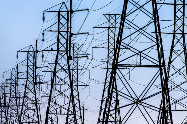
Opinion: Building an interstate system to move electricity could cost $50 billion — or less than what the Texas freeze and power outages cost users
James D. McCalley April 5, 2021
A macrogrid would make it easier and cheaper to move power across the five North American power grids
AGENCE FRANCE-PRESSE/GETTY IMAGES
Many kinds of extreme events can disrupt electricity service, including hurricanes, earthquakes, floods, wildfires, extreme heat, extreme cold and extended droughts. Major disasters can leave thousands of people in the dark. The Texas deep freeze in February knocked out 40% of the state’s electric generating capacity.
During such events, unaffected regions may have power to spare. For example, during the February blackouts in Texas, utilities were generating electricity from hydropower in the Pacific Northwest, natural gas in the Northeast, wind on the northern Plains and solar power in the Southwest.
Today it’s not possible to move electricity seamlessly from one end of the U.S. to the other. But over the past decade, researchers at national laboratories and universities have been working closely with industry engineers to design an interstate electricity system that can. And President Biden’s infrastructure plan would move in this direction by allocating billions of dollars to build high-voltage transmission lines that can “move cheaper, cleaner electricity to where it is needed most.”
My engineering research focuses on electric power systems. At Iowa State University we have worked to quantify the benefits that macrogrids can bring to the U.S. These high-capacity transmission systems interconnect energy resources and areas of high electricity demand, known as load centers, across large geographic regions.
A national highway system for electricity
Dwight Eisenhower had been thinking about a national interstate highway system for decades before he was inaugurated as president in 1953. Eisenhower argued that such a system was “as necessary to defense as it is to our national economy and personal safety.”
Congress agreed and passed the Federal-Aid Highway Act of 1956, which authorized the federal government to pay 90% of the cost of this $114 billion system, with states covering the rest.
Eisenhower was worried about evacuating cities in the event of nuclear war. The security argument for a macrogrid focuses on extreme events that disrupt the power grid. And the economic argument centers on moving wind, solar and hydro power from areas where they are plentiful to areas with high power demand.
A macrogrid would use different peak demand periods to reduce electricity costs.
Today the North American power grid is actually five grids, also known as interconnections. Two large ones, the Eastern and Western Interconnects, cover most of the lower 48 states and large swaths of Canada, while three smaller grids serve Texas, Alaska and northern Quebec. Each of these grids uses alternating current, or AC, to move electricity from generators to customers.
The Eastern, Western and Texas Interconnects are linked by high-voltage direct current, or HVDC, lines that make it possible to transmit power between them. These facilities are aging and can only transfer small quantities of electricity between grids. One way to think of a macrogrid is as an overlay that pulls together the existing U.S. grids and makes it easier to move power between them.
Sharing power across regions
President Biden has proposed sweeping action to achieve a clean energy transition in the U.S., including making electric power carbon-free by 2035. This will require adding a lot of new renewable generating capacity over the next 15 years.
What Biden’s First 100 Days Mean For You and Your Money
How will the new stimulus package affect the economy? Understand how today’s market dynamics, tax policies and more impact you with real-time news and analysis from MarketWatch. Our instant market data and insights will help you take action immediately—no matter your investing experience.
Wind and solar costs have fallen dramatically in recent years. Today power from new, large-scale wind or solar plants is cheaper than electricity from existing coal plants. Yet renewables provide only about 21% of U.S. electricity.
A macrogrid would reduce the cost of electricity from new wind and solar plants in two ways. First, it would enable high-quality renewable power – mainly Midwestern wind and Southern solar, and potentially Canadian hydropower – to supply coastal load centers. It is cheaper to build transmission systems that can move this power over long distances than to generate it from lower-quality, weaker sun and wind resources closer to cities.
Second, a macrogrid would make it possible to share energy production and grid services between regions. This strategy takes advantage of time differences due to time zones and the fact that electricity demand tends to peak at certain times of day, such as when people arrive home in the evening. And electricity prices rise and fall during the day with demand.
For example, at 3 p.m. Pacific Time, power demand is relatively low on the West Coast, which means the cost of that electricity is also low. Excess Western electricity could be used to supply demand on the East Coast, which peaks daily simultaneous with this 3 p.m. West coast “low” which occurs at 6 p.m. Eastern Time. Four hours later, when the West Coast hits its 7 p.m. Pacific Time daily peak, it would be 10 p.m. on the East Coast, which would have extra generation to share westward.
Capacity sharing also works because annual peak power demand occurs at different times of year for different regions. Each region is required to have access to enough generation capacity to meet its annual peak load, with some margin to cover generation failures. A macrogrid would enable regions to share excess generating capacity when it’s not needed locally.
This strategy provides benefits even when annual peaks in two regions differ by only a few days. When they differ by weeks or months, the payoff can be large. For example, power demand in the Pacific Northwest typically peaks in winter, so the region could borrow capacity from the Southwest and Midwest, where demand peaks in summer, and vice versa.
Building transmission saves money
In a study that I published in 2020 with academic and industry colleagues, we showed that without a macrogrid it would cost more than $2.2 trillion from 2024 through 2038 to develop and operate the nation’s electric power system and achieve 50% renewable power generation in 2038. This includes the costs of adding 600 gigawatts of new generating capacity that would be almost entirely wind and solar; operating costs for remaining fossil and nuclear power plants; and building new AC transmission lines to connect new power plants to customers.
However, we calculated that if the U.S. spent $50 billion to develop a macrogrid, the total long-term cost of developing and operating the nation’s electric power system and achieving 50% renewable electricity in 2038 would decrease by more than $50 billion. In other words, by making it possible to share power across regions and deliver high-quality renewable power from remote areas to load centers, the macrogrid would more than pay for itself.
Some observers may worry that a nationally connected grid would be more vulnerable to cascading blackouts than our existing system. In fact, a macrogrid would actually be more reliable because HVDC provides increased grid control capability through its flexible converter stations.
Industry leaders and clean energy advocates are calling for the U.S. to pursue macrogrid development. But North America is lagging behind most of the world in developing interregional power lines to tap low-cost clean energy resources. And if $50 billion seems like a big investment, consider this: It’s also the estimated minimum cost of outages and energy price spikes during the Texas deep freeze.
Shortly after Lydia Chambers had her first child, in 1995, her family moved to a new home in Ohio. “It was this neighborhood with perfect lawns,” recalls Chambers, now 60. In her previous home, when a swath of dandelions appeared shortly after she and her husband moved in, she spent two weeks pulling them out by hand.
In their Ohio home, however, she had no time to take care of the yard. So she hired a service to come and treat it. At the time, she didn’t realize that the chemicals the service used might be dangerous. “Even though I kind of sensed it . . . I didn’t know,” she says.
In her professional life as a hydrogeologist, Chambers was beginning to learn about how long-term, low-dose exposures to dangerous chemicals could lead to cancer and other chronic diseases. This made her increasingly suspicious of the pesticides her landscaping company applied. By 2005, her family had moved to New Jersey and her elementary school-aged kids were playing in the yard constantly. As she did more research, she learned a particularly disturbing fact: One common weed killer, 2,4-dichlorophenoxyacetic acid (2,4-D), was also an ingredient in Agent Orange, a chemical used during the Vietnam War.
“I guess if anything flipped a switch, it was that,” she says. Chambers and her husband finally committed to taking care of their yard with no synthetic pesticides, herbicides, or fertilizers—even if that meant it sprouted a few weeds. “I was proud that I had a few weeds in my grass,” she says. “It was a symbol I was doing the right thing.”
For many Americans, however, a pristine lawn is the goal, and weed-free grass is big business. American consumers spend about $35 billion per year on lawn and garden products, according to market research firm Mintel. Professional lawn-care services and consumers going the DIY route choose from a variety of pesticides and fertilizers, many with familiar brand names, such as Roundup and Scotts.
The sense of unease that Chambers felt about pesticides is grounded in evidence: A growing body of research has linked many of them, even at low levels, to potential health problems such as cardiovascular disease, says Consumer Reports senior scientist Michael Hansen, PhD, an expert in environmental health.
Also, while synthetic lawn-care products may be helpful to your yard in the short term, they can harm beneficial organisms in soil and won’t lead to a healthy ecosystem in the long run. “You wonder,” asks Jay Feldman, executive director of Beyond Pesticides, a nonprofit that advocates for transitioning away from synthetic pesticides, “why are we still using these things?”
Part of the problem is that even when consumers look for alternatives to traditional lawn chemicals, navigating the marketplace can be tricky. Unlike with food, there’s no legal definition of “organic” when it comes to lawn products, so it’s hard to assess the safety of a product that advertises itself as “organic,” “natural,” or “environmentally friendly.”
Still, it’s possible for consumers to move away from conventional lawn care. It just requires a bit of strategy, a few new habits, and some fresh ideas about what your yard should look like.
Health Harms of Lawn Care
On one hand, it’s a minority of lawn owners who hire lawn-care companies or add fertilizers or pesticides to their lawns. In a February 2021 CR nationally representative survey of 1,772 lawn owners, 51 percent said they don’t use any pesticides or fertilizers on their lawns. And according to Peter Groffman, PhD, a professor at the Advanced Science Research Center at the City University of New York’s Graduate Center, who studies ecosystem ecology, “the biggest group of homeowners are what we call passive land managers—they just mow.”
Still, many American homeowners strive for a perfectly uniform, bright green lawn. And according to research by Paul Robbins, PhD, professor and dean at the Nelson Institute for Environmental Studies at the University of Wisconsin-Madison, many do this in spite of misgivings about the sometimes mysterious chemical inputs involved.
Lawn chemicals pose short- and long-term risks to health, and children are particularly vulnerable. Kids can accidentally ingest pesticides if they get their hands on them. Although acute poisonings are relatively rare, poison control centers still logged around 34,000 cases regarding pesticide exposure among children 5 and younger in 2019, according to the American Association of Poison Control Centers.
The long-term risks of chronic exposure to chemicals on our lawns are much harder to quantify than acute poisonings, but plenty of research has been conducted into how it may affect health. One thing we know: Lawn chemicals don’t just stay on the lawn. Research has demonstrated that pesticides can be tracked inside on shoes and clothes, where they then settle into the dust on floors and other surfaces. There, children, especially young ones who crawl around on the ground and explore the world by putting things in their mouths, are more likely to get these substances into their system.
The prenatal period and early childhood are also times when people are more vulnerable to the risks of these repeated tiny exposures, which may have long-term effects, says Sheela Sathyanarayana, MD, a pediatrician and an environmental epidemiologist at the University of Washington and the Seattle Children’s Research Institute.
Still, the specific health effects of cumulative exposure to individual pesticides are difficult to tease out, in part because pesticides are designed to be toxic to living organisms. Scientists don’t typically expose people to them on purpose to find out what happens, as they do with medications. The evidence we do have—based on observational studies and experiments in animals and in cells—is open to interpretation.
Take, for example, the herbicides 2,4-D and glyphosate (the active ingredient in Roundup). They were the two most common active ingredients found in home and garden pesticides used in 2012, the last year for which data on national pesticide usage was available from the Environmental Protection Agency. The International Agency for Research on Cancer, a part of the World Health Organization that investigates the causes of cancer in humans, classifies 2,4-D as a possible carcinogen and glyphosate as a probable carcinogen.
Still, the science isn’t perfectly clear. The IARC’s classifications of carcinogens only indicate the strength of the evidence showing a given substance’s link to cancer. But chemicals in the same category could pose very different levels of real-world risk. Bayer, glyphosate’s manufacturer, told CR that the IARC’s analyses of carcinogens “do not reflect real-world exposure,” meaning the agency doesn’t say whether the amount of a substance you would typically be exposed to is enough to be dangerous.
The EPA has ruled that there isn’t good enough evidence to say whether 2,4-D causes cancer in humans—and that glyphosate probably doesn’t. The EPA also says that although 2,4-D was indeed an ingredient in Agent Orange, it was a different component, known as dioxin, that was found to cause cancer. And Lindsay Thompson, executive director of the Industry Task Force II on 2,4-D Research Data, told CR that regulators have “consistently found 2,4-D not to have adverse human health impacts” when used as directed on the label.
A variety of studies, particularly among agricultural communities exposed to pesticides through their work or by proximity to farms, have linked these and other common lawn chemicals to an increased risk of other health problems, too. These include neurological issues, respiratory irritation, asthma, and liver and kidney damage. One 2015 study even suggests that both 2,4-D and glyphosate could be contributing to the development of antibiotic-resistant bacteria.
What’s more, several common lawn pesticides are suspected endocrine disrupters, meaning they might interfere with the body’s hormones. This is thought to occur at very low doses during certain vulnerable phases of life, such as the prenatal period and early childhood. Endocrine disruption may contribute to a range of issues, including diabetes and reproductive and developmental problems.
Still, industry groups maintain that the EPA’s approval of existing lawn pesticides means the chemicals should be safe to use as directed on the label. Responsible Industry for a Sound Environment, an association representing pesticide and fertilizer industry players, says the EPA reviews hundreds of studies to arrive at its approval of a pesticide. And Andrew Bray, vice president of government relations for the National Association of Landscape Professionals, says, “We look at EPA as the experts.”
The Limits of Regulation
It can be hard for consumers to know what to make of all this, especially when studies come to contrasting conclusions. After all, if these chemicals posed a real danger, why would they still be on store shelves?
In fact, David Dorman, PhD, a professor of toxicology at NC State College of Veterinary Medicine in Raleigh, N.C., says many dangerous products have been banned in the U.S., including DDT. Modern pesticides, he says, are “so much safer than what was used even 40, 50 years ago. So progress has been made.”
In theory, the EPA’s approach to regulating pesticides is precautionary—it requires manufacturers to demonstrate a chemical’s safety before bringing it to market. But many consumer advocates, including CR’s Hansen, say the EPA’s testing requirements are outdated and don’t reflect the latest in toxicological science. That allows some significant harms of pesticides to go undetected.
The problem, says Laura Vandenberg, PhD, associate professor of environmental health sciences at the University of Massachusetts Amherst, is that a clearer understanding of some of the most serious potential effects—such as cancer—may take decades to emerge. In that time, millions of people will have already been exposed unnecessarily, she says.
The EPA told CR that it is in the process of incorporating endocrine disruption into its standard tests for pesticide safety, and that it is implementing a set of new evaluation methods designed to reduce the need for animal testing. The agency says its risk assessment “ensures that when a pesticide is used according to the label, people and the environment are adequately protected.”
Environmental Impact
Lawn chemicals don’t just stay on your lawn or end up in your household dust. They can also sink deep into the soil, float off into the air, and be carried off by stormwater, ultimately causing harm to a range of organisms they were never meant to target.
A major component in conventional lawn care, fertilizer, is a key source of water pollution. The excess nutrients get washed out by rain into local waterways or sink into groundwater.
Once the nitrogen and phosphorus from fertilizer reach a lake or pond, they can prompt an overgrowth of algae, which eat up the oxygen in the water. That can cause fish to die en masse and sometimes makes water toxic.
Synthetic fertilizers and pesticides may also gradually degrade the health of your soil by diminishing beneficial microbes and fungi. Healthy soil, along with being great for your grass, can help keep carbon out of the atmosphere, an important bulwark against climate change, says soil scientist Asmeret Berhe, PhD, professor of soil biogeochemistry at the University of California, Merced.
What’s a Consumer to Do?
If you’re concerned about the potential health and environmental effects of synthetic lawn chemicals, you might think the answer is choosing organic chemicals instead, or employing a green lawn-care service. But that can be harder than it sounds.
For agriculture, the federal government enforces regulations for food producers that would like to label their food as organic. But no federal laws exist for “organic” lawn-care products or service providers.
Before you hire a provider advertising organic lawn care, ask plenty of questions, says Michele Bakacs, associate professor and county agent with the Rutgers Cooperative Extension in New Jersey. “If the first thing the landscaper talks to you about is the type of product that they’re using, well, that may be a little bit of a warning sign,” she says. Instead, look for a provider that offers a soil test and talks to you about improving the health of your soil, putting the right plant in the right place for your yard and using several types of turfgrass. These are signs of a provider interested in the unique ecology of your yard.
Although uncertainty remains about the extent of the harms of lawn products, reducing risks to people and the environment is easy: Avoid using synthetic lawn chemicals. There are other ways to achieve the same goals that are better for your lawn and for your family (see “How to Rehab Your Yard”).
It can take a bit of a mindset shift, says Joseph R. Heckman, PhD, an extension specialist and professor of soil science at Rutgers University in New Brunswick, N.J. “If you want to have an organic lawn, you have to have a little bit of tolerance for something less than perfect,” he says.
Over the years, the practice of pesticide-free yard care has evolved for Lydia Chambers and her husband. They still live in New Jersey, and Chambers now considers herself an environmental activist. Their latest effort: converting much of their 3-acre property from lawn into meadow. Soon, in place of acres of trimmed turf, they’ll have a spread of native wildflowers and grasses. The meadow will encourage a more diverse ecology in her lawn, she says—and there’s a bonus: “It will be way easier than handling more flower beds.”
Editor’s Note: This article also appeared in the May 2021 issue of Consumer Reports magazine.
Every two weeks, Dawn Upton floods her lawn. She treks into her back yard, twists open two valves big as dinner plates, and within minutes is ankle-deep in water.
“You have to have irrigation boots, girl,” she says during a video tour of her property in Mesa, a suburb of Phoenix, Arizona. She flips her camera to reveal green grass, then tilts her phone skyward at four towering palm trees. As she walks, she pans across pecan, pomegranate, and citrus trees – lemon, orange, a grapefruit sapling. A tortoise, between 80 and 100lbs, lumbers toward her, chewing. “There’s Simba,” Upton says. “Hey buddy! What is that, Simba? You can’t eat it.” She pats him affectionately on the head.
This lush half-acre is Upton and her husband’s oasis, fed by flood irrigation in the heart of the Sonoran desert.
Upton is among a handful of homeowners – by one accounting, just 1% – of metro Phoenix’s 4.4 million people to receive flood irrigation. The Salt River Project, the area’s largest supplier of such water, delivered almost 60,000 acre-feet of water to that small number of residents in 2019, or 7.5% of the water it delivered that year to all customers combined.
In that same year, the Salt River Project sent 36,003 acre-feet to Phoenix-area schools, parks, golf courses and churches (and 63,500 acre-feet to farmers – another story entirely) to irrigate trees and turf.
To provide scale for that type of usage: one acre-foot of water can sustain three Phoenix-area families for a year. The entire city of Chandler, Arizona, population 261,000, uses 60,000 acre-feet of water annually.
The water, untreated, is cheap. To flood her yard twice a week, except in winter, Upton pays $100 a year to Salt River Project and $350 to her subdivision’s irrigation water delivery district, a special taxation district she helped start. If it were city water, “we could never afford this,” Upton says. “It’d be over $600 a month.”
The total amount of raw water to irrigate lawns and trees in private homes, parks, and schools has changed little in the last 36 years. Some people deem the practice a harmless anomaly. Others defiantly defend it against a backdrop of conservation messaging and intensive planning for climate change, drought, and future water scarcity.
•••
Phoenix has a deep history of environmental injustice. Low-income communities and communities of color suffer disproportionately from Phoenix’s extreme heat, a problem compounded by water access and affordability.
No one appears to have studied how flood irrigation correlates with wealth or race. Research indicates white, wealthier people are more likely to live in grassier, shadier neighborhoods. In one study from 2008, local researchers found that during one heat wave, the temperature discrepancy between a wealthier neighborhood and a poorer one in Phoenix hit 13.5F. Trees and grass accounted for the difference.
Whiter, wealthier people were more likely to have more vegetation, and in turn, cooler climates, the authors found. That study did not examine how greener areas were watered, but any irrigation has costs. “Affluent people ‘buy’ more favorable microclimates,” the researchers concluded.
Cynthia Campbell, water resources advisor for the city of Phoenix, says she understands why wealthy neighborhoods might still have flood irrigation while poorer ones don’t, even if both have legal rights to the water: high-income families can afford to spend hundreds of dollars on water delivery, pipeline repairs, and irrigation-district taxes. For lower-income ones, that kind of spending might not be possible.
Sarah Porter, director of the Kyl Center for Water Policy at Arizona State University (ASU) Morrison Institute, sees “two Phoenixes”. One is water-rich, the other water-poor, she says.
•••
Step away from Phoenix’s suburban sprawl into what little natural desert now remains, and you’ll find yourself in a dense ecosystem. Saguaro cacti stretch 40ft high, and barbed cholla stand alongside outstretched ocotillo plants. In the spring, after winter rains, a faint sage green carpets the desert floor.
Only in recent decades has the landscaping of metro Phoenix begun to resemble the surrounding desert. In 1978, grass dominated 80% of home landscapes. By 2014, that had dwindled to less than 15%, as the popularity of desert landscaping, or xeriscaping, grew. The area receives on average 8in of rainfall a year.
Urban flood irrigation reflects an essential tension in the management of Arizona’s water. On one hand, city and state leaders seek to reassure everyone that the region has sufficient water. Arizona’s economy has long been tied to growth, and leaders don’t want to scare off would-be residents with warnings of scarcity, like the fact that groundwater is over-pumped, that the state is exploring options to desalinate ocean water or brackish groundwater, or that Arizona will likely soon take mandatory cuts to its share of Colorado River water.
On the other hand, cities in this bastion of Sunbelt conservatism encourage residents to use water “wisely”.
Avoiding ordinances limiting individual water use, they instead have water-conservation websites, literature on optimizing watering systems, rebate and incentive programs, and workshops encouraging residents to consider low-water desert landscaping and low-flow toilets. They don’t demand that residents use less water, while other US cities do.
The average resident in metro Phoenix, where water prices are among the lowest in the nation, consumed more than 115 gallons of water per day in 2018. That’s down from about 135 in 2005, but still well above the average resident of Tucson (less than 85 gallons), which never had comparable access to water. The 2015 US average consumption was 83 gallons per day.
Large-scale changes to urban flood irrigation would come at a cost – converting to drip or sprinklers is expensive. A common claim is that trees raised on flood irrigation will die without it, but some evidence suggests otherwise. Two studies have found that mature citrus and olive trees, both of which are present in Phoenix, can respond positively when converted from flood to sprinkler, drip, or other irrigation, although they take a few years to adapt.
Meanwhile, Phoenix has an urban heat island problem – concrete and asphalt absorb the sun’s radiation during the day and release it at night, worsening every year – which flood irrigated trees and grass may assuage. Average night-time temperatures today are nearly 9F hotter than they were 50 years ago. Last year, Phoenix broke records with the number of days over 100F; its deadly summer heat can exceed 120F.
It’s just not popular to regulate people’s water use
Advocates of flood irrigation also invoke the desire to maintain the historic character of a neighborhood, Phoenix’s “oasis” feel, and, inevitably, the property values commensurate with both.
Wendy Wonderley moved to Arizona in 1984. Before retiring to Indiana in January, she lived in several Phoenix neighborhoods with flood irrigation, calling them “very pleasant to live in”. She frames flood irrigation as a question of values.
“If you’re going to live here in this desert,” Wonderley explains, “Then you’re going to have to alter some of the attributes of it.”
“If Phoenix as a society decides, ‘Nope, we really want desert vegetation everywhere,’ then that’s that, but it would be a real shame,” she says.
“It’s just not popular to regulate people’s water use,” says Kelli Larson, a professor of geography at ASU who has studied landscape choices and municipal ordinances. In a 2017 paper she co-authored, she found that despite campaigns to urge people to switch to desert landscaping, preferences for lush, grassy landscapes still exist, especially among long-term residents. Many want more grass than they have.
In another study published last year, Larson and her co-authors examined municipal landscaping ordinances in metropolitan areas across the US, including Phoenix. They found that 68% of the two dozen municipalities in greater Phoenix stress water conservation, compared to 87% of municipalities in the Los Angeles area, and that a greater proportion of municipalities in the water-rich Minneapolis-St Paul area (68%) restrict landscape irrigation than do those around Phoenix (56%).
Pending water scarcity in Phoenix, Larson adds, is less about whether it will be available, and more about to whom. “It’s going to become institutionally limited, economically limited, way before it’s going to become actual physical scarcity,” she says.
Tempe, southeast of Phoenix, still operates flood irrigation for about 900 residents and 16 city parks. It recovers just half those costs from users. On a video call, Braden Kay, Tempe’s director of sustainability, explains the city’s support for flood irrigation partly as a need to maintain large trees for cooling. Terry Piekarz, Tempe’s municipal utilities director, who is also on the call, nods. “We’re not saying, ‘Don’t [use water],’” he says, echoing other city officials interviewed for this article. “We’re saying, ‘Use water wisely.’”
•••
Under Arizona’s labyrinthine water laws, transferring water from one place to another is difficult. All water from the Salt River Project must be used on Salt River Project lands – designated a century ago by legal decree. Similar legal and jurisdictional challenges affect Arizona’s share of the Colorado River and its groundwater. Although the effects of ongoing drought and climate change, including less surface water, are prompting calls for greater flexibility in managing water, options remain limited.
For example, if Porter were to decline her own home’s allocation of flood irrigation water – which she has a “complex relationship” with – it can’t be sent to, say, water-stressed North Phoenix, which isn’t legally entitled to it. Instead, when she declines her water, it goes to the municipality where she lives, Phoenix, for treatment and distribution to Salt River Project territory.
Someday, Porter dreams, that could change.
Her wish is that people like her, who have irrigation rights, could one day forgo their own allocation and instead opt into alternative water uses, like watering trees or rehabilitating dry riverbeds.
She has also spoken with Salt River Project about the possibility of installing a tank in her yard to collect flood irrigation water to use in a less water-intensive sprinkler system – an option that is legal but expensive.
As for Dawn Upton, she says she’s aware of living in a desert – she turns off the faucet when brushing her teeth – and sometimes questions whether everything that made flood irrigation possible should’ve been done at such a massive scale at all. But, that can’t be undone. Plus, she adds, “when you look at this lawn, I don’t think I want it any other way”.
Florida county fears “imminent” reservoir collapse
Li Cohen April 4, 2021
Some residents in Manatee County, Florida, were evacuated from their homes over Easter weekend as officials cited fears that a wastewater pond could collapse “at any time.” Florida Governor Ron DeSantis declared a state of emergency for the area on Saturday.
County officials said the pond, located at the former Piney Point phosphate processing plant, has a “significant leak,” according to CBS affiliate WTSP-TV. The Manatee County Public Safety Department told people near the plant to evacuate due to an “imminent uncontrolled release of wastewater.”
“A portion of the containment wall at the leak site shifted laterally,” said Manatee Director of Public Safety Jake Saur, “signifying that structural collapse could occur at any time.”
Manatee County Public Safety Department initially sent out emergency evacuation notices on Friday for those who were within half a mile of Piney Point, and by 11 a.m. Saturday, evacuation orders were extended to people within one mile north of the reservoir’s stacks of phosphogypsum — a fertilizer waste product — and those within half a mile to the south of the site. Surrounding stretches of highway were also closed to traffic.
Related: Bacteria on Florida beaches proves deadly
Mandatory evacuations were extended an additional half mile west and one mile southwest of the site on Saturday evening. Manatee County Public Safety Department said that 316 households are within the full evacuation area.
The closure of U.S. 41 will be expanded south from Buckeye Road to Moccasin Wallow Road. Moccasin Wallow Road will be closed west of 38th Avenue East. There are an estimated 316 households in the evacuation area. Those households will all receive an emergency alert to evacuate.
Phosphogypsum is the “radioactive waste” left over from processing phosophate ore into a state that can be used for fertilizer, according to the Center for Biological Diversity.
“In addition to high concentrations of radioactive materials, phosphogypsum and processed wastewater can also contain carcinogens and heavy toxic metals,” the Center said in a statement on Saturday. “For every ton of phosphoric acid produced, the fertilizer industry creates 5 tons of radioactive phosphogypsum waste, which is stored in mountainous stacks hundreds of acres wide and hundreds of feet tall.”
Manatee County Commissioner Vanessa Baugh said in a statement Saturday that the “public must heed that notice to avoid harm.”
Officials are on site conducting a controlled release of water, roughly 22,000 gallons a minute.
The water that is currently being pumped out by officials in order to avoid a full collapse is a mix of sea water from a local dredge project, storm water and rain runoff. The water has not been treated.
“The water meets water quality standards for marine waters with the exception of pH, total phosphorus, total nitrogen and total ammonia nitrogen,” the state said in a statement. “It is slightly acidic, but not at a level that is expected to be a concern, nor is it expected to be toxic.”
Florida Commissioner of Agriculture Nikki Fried wrote a letter to DeSantis on Saturday urging an emergency session of the Florida cabinet to discuss the situation. She wrote that the leaking water is “contaminated, radioactive wastewater,” and noted that this leak is not the property’s first.
“For more than fifty years, this Central Florida mining operation has caused numerous human health and environmental disasters and incidents,” Fried wrote. “There have been numerous, well-documented failures — which continue today — of the property’s reservoir liner, including leaks, poor welds, holes, cracks and weaknesses that existed prior to purchase by the current owner, HRK Holdings, and exacerbated since.”
Video of a Manatee County Commissioners meeting provided insight into what happened prior to the leak. On Thursday afternoon, Jeff Barath, a representative for HRK Holdings, the company that owns the site, appeared emotionally distressed while briefing the Manatee County Commissioners about the situation.
“I’m very sorry,” he said. He told commissioners he had only slept a few hours that week because he was trying to fix the situation, and through tears, said he first noticed “increased conductivities within the site’s seepage collection system” 10 days prior on March 22. This system, he said, offers drainage around the gypsum stacks.
He said he immediately notified FDEP of his concerns.
“The water was changing around the seepage. We went into a very aggressive monitoring program,” he said, to find out where the seepage was coming from.
They discovered the south side of the stack system had “increased in conductivity” and that the acidity of the water, which is normally around a 4.6, had dropped to about a 3.5, which indicated an issue.
After a few days, the water chemistry had not improved and water flows were increasing from about 120 gallons a minute to more than 400 gallons per minute in less than 48 hours, Barath said. Last Saturday night, the flow rates increased to “rates that I could not even estimate to you,” he said.
Water was filling the stacks so quickly that the ground was starting to rise, Barath said. This “bulging” was temporarily stabilized but then extended hundreds of feet.
Barath submitted a report to the state on March 26, according to the state-run “Protecting Florida Together,” website, which was created by DeSantis to allow more transparency about state water issues.
“I was anticipating that the gypstack itself was destabilizing at a very rapid rate and recommended that we consider an emergency discharge,” he told commissioners. He said he feared that “overpressurizing” the system would result in “complete failure.”
“I’ve spent most of my days and nights constantly monitoring all aspects of this gypstack system and identifying failure points within it,” he said, noting that failure points were happening “constantly, I mean hourly.”
The Florida Department of Environmental Protection said that it ordered the company to “take immediate action” to prevent further leaks. On March 30, the department said that “pipes at the facility are repaired” and controlled discharges were initiated to prevent any pressure buildup.
However, based on Barath’s testimony at the meeting, the situation was far from over. He concluded his address by saying they were doing “everything possible to prevent a true catastrophe.”
On Friday, another leak was detected in the south containment area of the facility. Despite overnight work to attempt to stop this and other leaks, Manatee Director of Public Safety Jake Saur said on Saturday that the situation was “escalating.”


 / Credit: SNOTEL