California’s Park Fire now among largest in state history as evacuation orders spread
Scott Sistek – July 27, 2024
https://s.yimg.com/rx/ev/builds/1.7.4/pframe.htmlScroll back up to restore default view.
CHICO, Calif. — The Park Fire burning in Northern California near Chico has now become one of the largest wildfires in state history as flames continue to grow, causing additional evacuations to now spread across four counties and taking aim at a community that is still reeling from a deadly wildfire just six years ago.
But some good news emerged for firefighters with the weather forecast as the weekend began without the triple-digit heat and Fire Weather Warnings of the past few days.
CAL Fire now estimates the Park Fire has burned nearly 350,000 acres as of midday Saturday, which ranks the fire as No. 7 on California’s list of most acreage burned by a fire. At least 134 homes and structures have been damaged or destroyed and another 4,200 are threatened, fire officials said. Over 50 community zones are now under evacuation warnings across 4 counties, spanning more than 4,400 people.
“Extreme fire behavior has occurred due to the slope and winds aligning, causing significant growth,” CAL Fire officials wrote in their Saturday morning update. “Damage inspection teams are working to identify structures that have been damaged or destroyed.”
So far, there are no reports of any deaths, but two people have been treated for minor injuries.
Vanessa Starling, who lives near the heavily damaged town of Cohasset, told FOX 2 Bay Area they could hear the sound as they evacuated their home.
“It was pretty crazy, there is one spot that had a little fire tornado going on. We could hear it, just this roaring sound, you can hear the fire roaring as we were leaving,” Starling said, worried about her family home. “We have property that’s been in our family since 1905.”
Late Friday night, the entire town of Paradise, California was placed under an evacuation warning, which means all residents should get ready to run if the fire gets closer.
“Fire behavior and predicted winds require all residents in Paradise to prepare to evacuate and await further information,” CAL Fire officials said.
It’s a particularly daunting reminder of wildfire dangers for this community that was devastated by the fast-moving Camp Fire in 2018 that left dozens dead as flames raced through town.
Additional evacuation shelters have opened in Red Bluff, Los Molinos, and the Butte County Fairgrounds in Gridley in addition to shelters in Chico.
Nearly 2,500 firefighters are dedicated to fighting the blaze as of Friday night, and California Gov. Gavin Newsome declared an emergency, allowing additional state resources to flow toward the fire.
The Park Fire began Wednesday as a bizarre care of arson, investigators said.
Witnesses spotted a man next to a car where a fire had started under the left wheel of what turned out to be the suspect’s mother’s vehicle, and watched it burn, according to Butte County District Attorney Mike Ramsey.
The man climbed into the vehicle for a few moments, then got out and pushed the flaming car down a 60-foot embankment into a gully, investigators said. The burning car eventually became engulfed, spreading flames into the nearby brush and eventually tearing through nearby neighborhoods.
The suspect was identified later that evening and arrested early Thursday morning. He’s being held in the Butte County Jail without bail, awaiting arraignment on Monday.
After days of fighting triple-digit heat and blustery winds that have triggered Fire Weather Warnings across much of Northern California, the weather pattern has finally shifted to give firefighters a temporary reprieve.
Cooler, ocean breezes have pushed inland, not only knocking temperatures down into the upper 80s and low 90s but increasing the humidity.
No weather alerts were in effect for Saturday and the pattern was expected to hold through the middle of the week. However, hotter weather and perhaps a return to triple digit heat was looming for later in the week.
Oregon wildfire explodes to half the size of Rhode Island
Rich McKay – July 26, 2024
Wildfire in Forest Ranch, CaliforniaWildfire northeast of Chico, CaliforniaWildfire in Forest Ranch, California
(Reuters) -Winds and lightning strikes have sparked and fanned wildfires across the Pacific Northwest this week, including the largest fire currently burning in the U.S., which was rapidly expanding near the Oregon-Idaho border on Friday.
The Durkee Fire near Huntington, Oregon, has scorched 600 square miles (1,600 square km), an area more than half the size of Rhode Island’s land mass, authorities said. It is threatening several towns.
The blaze was set off by lightning on July 17, and wind gusts up to 60 mph (100 kph) drove the flames across brush, timberland and ranches, killing hundreds of cattle. The fire was only 20% contained on Friday, officials said.
While there is zero chance of rain through next week, winds have dropped and cooler air is in store, said meteorologist Marc Chenard of the National Weather Service.
“Hopefully it gives firefighters a break,” he said.
As of Thursday, wildfires this year have burned almost 1 million acres (400,000 hectares) in Oregon and 125,900 acres in Washington, according to the Northwest Interagency Coordination Center in Portland, Oregon.
In 2020, the worst year in recent memory, Oregon wildfires scorched more than 1.14 million acres, according to a tally by CBS TV affiliate KOIN.
In California, the Park Fire, believed to have been started by an arsonist, has forced the evacuation of more than 4,000 residents in Butte County, about 100 miles northeast of Sacramento.
A suspect was arrested on Thursday, accused of pushing a burning car down a bone-dry gully.
The fire grew uncontrolled overnight from 125,000 acres on Thursday to 178,090 acres on Friday afternoon, according to the California Department of Forestry and Fire Protection. More than a hundred buildings had been damaged or destroyed.
“The biggest challenge with this fire is getting to it,” said Fire Captain Dan Collins. “It’s steep land with almost no roads. It’s hard to get our people and equipment to the fire lines.”
More than 1,600 firefighters were deployed to contain the blaze, CalFire said.
Forecasters warned that winds would reach 30 miles mph (50 kph) on Friday and through the weekend. Combined with low humidity, it is a recipe for rapid growth, officials said.
Smoke from fires in western Canada and the Pacific Northwest have brought hazy skies and unhealthy air from the Rocky Mountains to Minneapolis and as far east as Detroit, weather reports said.
Denver had the worst air quality in the U.S. on Friday and ranked the 30th worst in the world, according to IQAir, a group that tracks air pollution across the globe.
Much of the smoke coming into the Central and Eastern U.S. comes from a raging wildfire in the mountainous Jasper National Park in the Canadian province of Alberta.
The park and the town of Jasper, which draws more than 2 million tourists a year, were evacuated on Monday, displacing 10,000 residents and 15,000 park visitors. As much as half of the structures in the town could be damaged or destroyed, officials said, as the blaze burned more than 89,000 acres as of late Thursday.
Videos posted on social media show entire streets leveled by the blazes in the Alberta province, with scorched trees, charred metal skeletons of cars, and nothing but rubble where homes and businesses had stood.
(Reporting by Rich McKay in Atlanta; Additional reporting by Jonathan Allen; Editing by Rod Nickel, Sandra Maler and William Mallard)
Two fires moving at speeds of more than 60 miles-an-hour converged in the Canadian Rockies on Wednesday, burning through the town of Jasper — along the Athabasca River in Alberta, Canada — destroying nearly a third of its structures.
More than 25,000 residents and visitors were evacuated this week from the tourist town and surrounding Jasper National Park, officials said.
Rain and cooler temperatures helped to subdue the fire somewhat on Thursday, officials said, but the fire is still burning. Firefighters continued to fight fires in the town, moving from one building to another on Thursday, according to an update from Parks Canada.
A male elk crosses the Yellowhead Highway, a route roughly followed by Kinder Morgan’s Trans Mountain Pipeline through the Rocky Mountains, in Jasper National Park, Alberta, Canada November 14, 2016.
“There’s no denying this is the worst nightmare for any community,” said Alberta Premier Danielle Smith.
“For many generations, the town of Jasper and the park surrounding it have been a source of pride with some of the most beautiful scenery in the entire, in the world,” said Smith, as she was overcome by emotion.
A general view shows the Howse Pass Viewpoint between the Banff and Jasper national parks, in Alberta, on September 9, 2022.
How much of Jasper was damaged in the fires?
Of 1,113 structures in the town of Jasper, 358 of them were destroyed in this week’s fire, according to a Friday update from the incident command team overseeing the firefighting effort, which includes Parks Canada.
The fire is estimated at roughly 88,000 acres in size, although areas within that perimeter may be only partially burned or not burned at all.
Firefighters said they were able to protect the town’s critical facilities, including the hospital, emergency services buildings, both the elementary and junior/senior schools, an activity center and the wastewater treatment plant.
The fire damaged a number of bridges throughout the national park, including the Moberly Bridge and the Old Fort Point Bridge, the park said. Bridges on the region’s famed Icefields Parkway will be assessed for structural damage, and parks officials said that would slow down access to the picturesque Maligne Lake southeast of town.
The most significant structural damage occurred on the town’s southwest side, officials said Thursday.
Crews continue to fight the fire “and we remain focused on making it safe for the people of Jasper to come home,” the Friday morning update stated. The area remains closed for public safety and the evacuation order remains in effect.
Jasper’s residents and visitors scoured social media posts for news this week trying to get word about their community.
Bishop Stephen London with the Anglican Diocese of Edmonton confirmed in a Facebook post that the St. Mary and St. George Anglican Church in Jasper was destroyed by the flames.
Jasper Mayor Richard Ireland called the fire an “unprecedented challenge.”
The blaze ravaged Jasper, Ireland said in an update. “The destruction and loss that many of you are facing and feeling is beyond description and comprehension.”
What is Jasper, Canada known for?
“Known for its vast wilderness, majestic peaks, abundant wildlife and outstanding natural beauty, visitors from all over Canada and round the world travel here to experience this very special place,” Parks Canada’s website says.
Jasper is a tourist destination for those who visit the Rockies and Jasper National Park. The park is a World Heritage Site with more than 2 million visitors a year passing through the gates, according to the town’s website. Tourists travel the Icefields Parkway between Jasper and Banff National Parks and visit Athabasca Falls and Athabasca Glacier.
Idyllic scene in Maligne Lake in Alberta’s Jasper National Park in 2016.
One of Canada’s national treasures, the park boasts over 2.7 million acres and is the largest in the Canadian Rockies. It was established as Jasper Forest Park reserve in 1907 and became a national park in 1930. About 70 species of mammals live there, according to National Geographic, including grizzly bears, moose and elk. The park serves as a preserve for species of wildlife that have declined in other areas.
What’s the Athabasca Glacier?
The Columbia Icefield is the largest remnant of a thick ice mass that once covered much of the area in the Canadian Rockies. The Athabasca Glacier flows from the icefield and down into the valley, where tourists can walk up to the toe of the glacier, following a series of markers that show how much the warming climate has melted the glacier.
Athabasca Falls in Jasper National Park in 2016. Parts of the park were burned over in a fire on July 24-25, 2024.
The Athabasca has been averaging a retreat of about 16 feet a year. In 2023, when global average temperatures were their hottest on record, the Athabasca Glacier saw more glacial melt than in any of the previous 10 years, according to Parks Canada.
Durkee Fire creates extreme storms, wind and closes I-84 in eastern Oregon
Emma Logan, Salem Statesman Journal – July25, 2024
The Durkee Fire in eastern Oregon reached 244,858 acres as of Wednesday morning. The area is expecting hurricane force winds along with thunder and lightning storms Wednesday night.
This story was updated at 9:30 a.m. Thursday
One of the biggest fires burning in the United States is the Durkee Fire in eastern Oregon. As of Thursday morning, the fire was reported to be at least 270,000 acres and is 0% contained. The National Weather Service said storms brought close to 3,000 lightning strikes in the area.
The Oregon Department of Transportation closed Interstate 84 from Pendleton to Ontario on Wednesday due to unpredictable fire activity in the area. ODOT does not have an expected opening and travelers should not plan to use I-84 for travel. Check TripCheck for updates.
Heading into Wednesday afternoon, the area is under a red flag warning, hurricane force winds and a flash flood warning, according to the Durkee Fire updates. The National Weather Service also expects extreme thunderstorms and lightning in the area.
Due to the immense heat the Durkee Fire is creating and the existing winds, it is creating its own storms and changing the overall wind patterns.
“We call those pyrocumulus and you end up with a thunderstorm over the fire because there’s so much heat and just enough moisture above the fire to get a storm that forms,” Mike Cantin, a meteorologist from the National Weather Service in Boise, Idaho, said.
This happens due to the air surrounding the fire being drawn toward the fire creating erratic winds in the area. The gusty winds created could spread to other areas and elevate the danger for firefighters.
The Durkee Fire in Baker County has impacted travel on Interstate 84 Tuesday and Wednesday. The Oregon Department of Transportation recommends using US 20 as an alternate route.
“The low elevation fuels, all the grass, the sagebrush, all of the trees below 6,000 feet are ready to burn. Any ignition source no matter how small can start another major wildfire,” Cantin said.
On Saturday, Gov. Tina Kotek invoked the Emergency Conflagration Act for the fire.
“The wildfires in Eastern Oregon have scaled up quickly,” Kotek said in a new release on Wednesday. “We are facing strong erratic winds over the region that could impact all fires. Rain is not getting through. Some communities do not have power. The situation is dynamic, and the teams on the ground are taking it day by day. I have deployed resources from the National Guard that are currently serving eastern and southwestern Oregon. I know these communities are supporting one another, doing their part to heed the guidance from officials and showing tremendous gratitude for our firefighters.”
On Friday, the Oregon State Fire Marshal sent structural protection resources in the form of firefighters and equipment to fight the fire in Eastern Oregon.
The fire was first reported last Wednesday and sparked by lightning strikes. The fire has brought level 1, 2 and 3 evacuations around Baker County. An evacuation map can be found at bit.ly/3YaNUJ0
“If you are outside, don’t create any sparks. Don’t drag a chain, if you are driving an RV make sure your chains are tied up, don’t park your car over grass, the heat of the engine could ignite it,” Cantin said. “This is one of those critical situations, that’s why fire are getting so big the weather is just right and the grass and sage and trees are ready to burn, all it takes is just a little bit.”
Here’s the latest on wildfires burning across Oregon.
Slate Fire burning 5 miles south of Detroit Dam
The Slate Fire in Willamette National Forest grew to at least 45 acres on Wednesday and was burning 5 miles south of Detroit Dam.
A multi-agency response performed suppression activities over Tuesday night. An air attack took place Wednesday as suppression attempts continue.
Forest Service Road 2212 will be closed from the dam to FS Road 1133 intersection to assist emergency crews’ access.
There are no current evacuation orders as of Wednesday afternoon.
Boneyard Fire reaches 49,716 acres at 3% containment
Boneyard Fire evacuation map.
A level 3 “Go Now” evacuation order has been issued in Monument and from the south Morrow County line, north to Forest Service Road 21 and to the east Morrow County line for the Boneyard Fire in northeastern Oregon.
The fire was reported to be 49,716 acres and 3% contained as of Wednesday.
There is potential for the Boneyard Fire to merge with the 56,139-acre Monkey Creek Fire to the east.
An evacuation center has been set up at Grant Union High School (911 S Canyon Blvd., John Day).
A community meeting for the fire is panned 6 p.m. Thursday at the Long Creek High School gym (375 E Main St., Long Creek).
Parts of Oregon see 75 days without rain as fires rage
As more than a dozen fires burned on national forestland in the Pacific Northwest, some areas have gone more than 75 days without rain as of Tuesday morning, according to the U.S. Forest Service.
The record dryness was partly due to the lack of moisture in the Pacific Northwest. The Fremont-Winema and Deschutes national forests had gone more than 75 days without rain.
The Rogue River-Siskiyou National Forest in southern Oregon and Wallowa-Whitman in the east had both gone at least 45 days without rain, as has the Okanogan-Wenatchee.
Crews work on the Falls Fire burning in Grant and Malheur counties. There were at least 14 fires burning on national forest lands in the Pacific Northwest Region on Tuesday.
The lightning storms last week produced more than 2,000 strikes in 48 hours, causing rapid wildfire growth in already dry timber regions.
“This is shaping up to be another monster fire year in the Pacific Northwest, and it’s just mid-July,” said Ed Hiatt, Pacific Northwest assistant fire director for operations.
Every year, 75% of wildfires are human-caused, according to the Forest Service. In an effort to reduce this, all 17 national forests in the region were in campfire restrictions.
Temperatures were expected to cool by the end of the week, but the lack of moisture was expected to continue to keep forests and grasslands at critical fire conditions, the Forest Service said.
Campfires temporarily banned at Oregon State Parks
Campfires are banned at most state parks due to dry conditions and the strain on firefighting resources, the Oregon Parks and recreation Department announced Tuesday. All parks east of the Cascades will be under campfire bans. Fires and open flames will also be banned at parks in high-risk areas until conditions improve.
A list of parks under the campfire ban are listed at bit.ly/4fdeLud
Several parks have been closed due to wildfires including Battle Mountain Forest Scenic Corridor, Farewell Bend State Recreation Area, East and West Hatfield Trailheads on the Columbia River Highway State Trail and Ukiah-Dale Forest State Scenic Corridor.
OPRD encourages visitors to check park webpages before visiting. Find updated information at stateparks.oregon.gov/
Ray Benson Sno Park temporarily closed to station firefighters
The Willamette National Forest has temporarily closed the Ray Benson Sno Park. The area will be used as an incident command post for nearby wildfires.
The Ray Benson site is located within the Santiam Pass Recreation Area. The access road FS Road 2690-902 will also be closed. The remainder of the Santiam Pass Recreation Area remains open.
Rocky Mountain Complex includes seven lighting started fires
Oakridge Lightning Fires map.
The lightning storm on July 17 ignited seven wildfires to the north, south and southeast of Oakridge and Westfir. The Rocky Mountain Complex Incident Team 1 assumed command of the fires on Tuesday.
Fire suppression efforts are underway beginning with fires deemed highest priority — Chalk, Coffeepot and Moss Mountain fires.
The Chalk Fire is the largest of the complex at 2,247 acres and 0% containment. Infrared flights on Tuesday revealed the fire grew by 1,000 acres. The Chalk Fire shares a perimeter with the 2021 Gales Fire scar, which should slow progress and help crews contain the flames.
Lane 1 wildfire prompts level 1 evacuation warnings
The Lane 1 Fire burning southeast of Cottage Grove has prompted Level 1 ‘Be Ready’ evacuation orders for areas east of Cottage Grove, according to the Lane County Sheriff’s Office. As of Tuesday evening, the fire has burned 1,090 acres.
Areas east of Disston starting at Brice Creek Road milepost 0.7 and following Brice Creek Road south are under the Level 1 notice.
The Lane County Sheriff’s Office has closed Brice Creek Road east of the Umpqua National Forest Boundary and all of Sharps Creek Road. People camping in the Brice Creek, Sharps Creek, Champion Creek, Bohemia and Fairview Peak areas are advised to leave now.
Air quality advisory issued for southern, central and eastern Oregon
The Department of Environmental Quality’s air quality advisory due to fire smoke issued on Monday is still in effect until further notice. The air quality advisory is for the following counties: Grant, Wheeler, Crook, Deschutes, southern Umatilla and southern Morrow, Klamath, eastern Douglas, and northern Harney and northern Malheur counties
The DEQ expects intermittent smoke in Union, Baker, Wallowa, Jackson, Josephine, Gilliam, eastern Lane and northern Lake counties due to smoke from fires in Oregon.
Areas east of the southern Oregon fires like Crescent and Diamond can expect periods of unhealthy air quality conditions, according to the DEQ. Roseburg and Cottage Grove should remain good with little impact from smoke.
Smoke levels can change rapidly. Up to date information can be found on the DEQ’s Air Quality Index.
Light winds expected to lessen fire activity of Pyramid Fire over next three days
The lightning-caused Pyramid Fire burning east of Sweet Home in the Tombstone Pass area north of Highway 20 and south of Detroit near Santiam Junction remains at 535 acres and 0% contained as of Wednesday morning.
Significant progress has been made toward the opening of roads and establishment of a control line around the fire’s perimeter, the news release said. Additional crews and firefighting equipment will be added to strengthen suppression efforts.
Due to the fire burning in an old-growth forest, fire behavior specialist Jeff Shelton does not anticipate significant fire activity to occur in the next three days. The light wind is causing the smoke to behave like a lid holding the fire’s activity.
There was increased fire activity in the southwest flank, but very little activity was observed in the remainder of the area, according to the update. The control focus on Tuesday was to protect the Middle Santiam Wilderness, private industrial timberlands and nearby communities.
The Linn County Sheriff’s Office announced Monday night “There is still no imminent danger to structures, the town of Sweet Home, or of closures to Highway 20” despite the fire behavior and dangerous conditions.
Linn County Sheriff Michelle Duncan issued a level 3 “go now” evacuation order for a large area of the Sweet Home Ranger District that mostly includes hiking trails and campgrounds in the Old Cascades region. The evacuation was coordinated with the U.S. Forest Service, and a closure of the area was likely. View a map of the closure area at tinyurl.com/LinnCoFireMap.
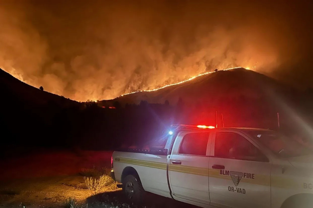
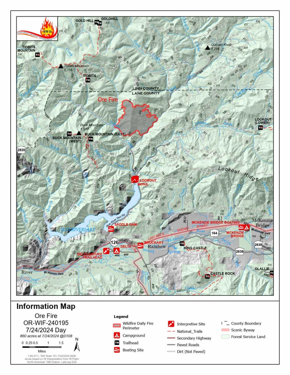
Ore Fire continues to grow amid rugged conditions and extreme fire behavior
Ore Fire information map.
The Ore Fire burning 7 miles northeast of Blue River was burning 860 acres as of Wednesday morning.
Fire managers are focusing on activities with the highest probability of success and least amount of risk to firefighters, communities and resources. The rugged and steep terrain, falling rocks, rolling debris, fire-weakened trees and extreme weather conditions continue to pose safety challenges for crews.
Burning debris rolling down steep slopes caused the fire to cross the established control line at FS 1509 Road on Tuesday. Firefighters were able to control the flames but falling debris will remain a challenge.
Buck Mountain Trail, Tidbits South and West Trail, Gold Hill Trail, Mona Campground, Lookout Campground and Saddle Dam Boat Launch are closed.
Other closures in the Willamette National Forest due to fire-impacted areas can be found at bit.ly/4dcWMCl
Homestead Complex reaches 910 acres
The Homestead Complex Fire, a group of fires in the Umpqua National Forest, had a combined 910 acreage total Wednesday morning.
The incident management teams assigned to the Homestead Complex and Diamond Complex will hold a joint community meeting at 5:30 p.m. on Wednesday in the Old Glide Middle School Gym.
On Tuesday, crews worked in both directions on the 258-acre the Horse Heaven Creek Fire, the most active in the complex, until fire activity intensified causing a switch to indirect tactics. Attempts at aviation intervention were thwarted due to thick smoke. Crews will try and build a containment line today, the news release said.
The steep and rugged terrain of the 267-acre No Man Fire makes it difficult to get firefighters on the ground near the fire’s edge. Crews will work to establish indirect control lines.
As of Wednesday, containment lines are being established for the 84-acre Reynolds Butte Fire and the 35-acre Lost Bucket Fire.
The 38-acre Fuller Lake Fire and 110-acre Bullpup Fire will remain unstaffed until resources become available.
The Umpqua National Forest issued closures for all of the Cottage Grove Ranger District and parts pf the Diamond Lake, North Umpqua and Tiller ranger districts. Boulder Flat Campground and Boat Launch are closed under the order.
BLM closes public lands due to wildfires southeast of Cottage Grove
Bureau of Land Management public lands southeast of Cottage Grove are closed due to wildfires in the areas of Sharps Creek and Clark Creek.
“The closure is for public and firefighter safety, and to allow fire suppression crews to continue to safely respond to the incident,” according to a Saturday news release from the BLM Northwest Oregon District.The closure area includes:
The Sharps Creek Campground and BLM-managed public lands southeast of the town of Dorena, surrounding Sharps Creek Road (County Road 2460 / BLM Road No. 23-1-12) and Clark Creek Road (BLM Road No. 23-1-13). It includes BLM lands in Township 22S, Range 1W, and Township 23S, Range 1W, Sections 1-3, 11-14, 22-24, 26-27, 33-34.
These areas are closed to the public and for activities including hiking, mining, hunting and camping.
BLM said Sharps Creek Road and Clark Creek Road are open to residents in the closure area.
Favorable weather helps crews fighting Microwave Tower Fire near Mosier
Crews were able to make progress by establishing lines on the east end of the 704-acre fire, as of Wednesday morning.
The fire has continued to creep down a north-facing ridge along I-84 and west of Mosier.
Authorities estimated 100 homes under level 3 and 500 residents were threatened in the Mosier area. Residents in Mosier west of the Columbia Gorge were being asked to evacuate due to the Microwave Tower Fire, which is being driven by strong winds.
Here are the evacuation levels for areas in Mosier related to the fire:
Level 3 “go now”: From Highway 30 south of Proctor Road, east to Huskey Road and the border of Mosier and west to the Hood River County line.
Level 2 “get set”: Mosier and from Huskey Road east to Mosier Creek Road and south to Jasper Lane.
Level 1 “be ready”: From Mosier Creek Road, east to Dry Creek Road, north to Mosier border and south to Osborn Cutoff Road.
There is a Red Cross shelter available for evacuees at Hood River Middle School, 1602 May St.,, Hood River, OR., 97031.
The fire started Monday afternoon west of Rattler Ridge west of Mosier.
The fire is burning in grass and timber and was being pushed eastwards by strong westerly winds.
“The fire has seen moderate activity with intermittent single tree torching, some flanking and smoldering creating a moderate amount of smoke,” according to a Wednesday update from the Oregon Department of Forestry. “The fire also saw growth backing down the north slope. With the expected increased winds today, crews are ready to address increased fire behavior. There is a potential for increased smoke in the area.”
20 fires burn at least 3,811 acres in the Diamond Complex
In the past 24 hours, 8 new fires at a combined 62 acres have been identified and added to the Diamond Complex on the Diamond Lake Ranger District of the Umpqua National Forest. The complex is 3% contained.
All fires are under a full suppression strategy with firefighters directly attacking the fire line where feasible.
These are the active fires in the complex:
Pine Bench: 1,472 acres (north of Highway 138 near Dry Creek)
Trail: 827 acres (east of Highway 138 on the west slope of Mount Thielsen)
Lemolo: 518 acres (north of Lemolo Lake on Bunker Hill)
Pig Iron: 27 acres (Pig Iron Mountain north of Highway 138)
Watson: 144 acres (north of Highway 138 on Watson Ridge)
Brodie: 95 acres (about 5 miles south of Highway 138 and south of Devils Canyon)
Trep: 101 acres (about 4 miles south of Highway 138)
Garwood: 5 acres (about 3 miles southwest of Mount Bailey)
Slide: 0.1 acres (northeast of Pine Bench)
Potter: 327 acres (north of Highway 138 about 2 miles southeast of Potter Mt.)
Ooya: 123 acres (north of Highway 138 about 1 mile northeast of Bird Point)
Clearwater: 7 acres (south of Highway 138 about 5 miles northwest of Diamond Lake)
Elephant: .07 acres (2 miles southwest of Lemolo Lake)
Lost Bear: 5 acres (2 miles south of Hwy 138)
Lost: 12 acres (4 miles south of Hwy 138)
The eight newest fires have not been named and are widely scattered in the area.
A level 2 “be set” evacuation warning was issued due to the Boulder Flat/Pine Bench Fire east of Roseburg and Glide in the North Umpqua Canyon near Toketee Falls. The evacuation was for homes in the Slide Creek area downstream to the Soda Springs area due to a fire near Soda Springs and Pine Bench in Toketee. A map of the evacuation area can be found here: bit.ly/4dc3qsB.
The weather on Tuesday was forecast to be lower in relative humidity and slightly higher in temperature. The conditions will support increased fire spread and spotting potential. This will add to the challenging fire behavior due to rugged and steep terrain.
Lemolo Fire reaches 404 acres in Douglas County
The Lemolo Fire in Douglas County had reach 423 acres as of Wednesday morning and was 0% contained.
The Douglas County Sheriff’s Office on Saturday night issued level 3 “go now” and level 2 “be ready” evacuation orders for the Lemolo Fire. The fire was reported to be at least 373 acres as of Sunday night.
Level 3 evacuations were issued for:
Bunker Hill Campground
Kelsay Valley Campground
The North Umpqua Trail between USFS 2612 Road and Windigo Pass intersection, west to North Umpqua Trail as it intersects with USFS 2612 Road.
This includes all areas on north and northeast side of Lemolo Lake, according to the sheriff’s office.
Level 2 evacuation orders have been issued for:
East Lemolo Campground
USFS 2614 Road south of Inlet Campground, including Kelsay Valley, Pumice Flat and Elbow Butte areas.
Falls Fire reaches 140,422 acres and 50% containment in Grant and Harney counties
The Falls Fire burning in Grant and Harney counties near Burns was 140,422 acres and was 50% contained as of Wednesday morning.
A cold front bringing wind and thunderstorms is anticipated to hit the Falls Fire area on Wednesday evening.
The fire was reported to be active on Monday afternoon due to southwest winds, which prompted growth along parts of the northern perimeter of the fire, according to the Tuesday morning update.
On Tuesday, Oregon State Fire Marshal crews were set to remain active on the northeast, east and southern parts of the fire.
The Oregon State Fire Marshal requested help from California to protect life and property against the fire on Friday.
The California Governor’s Office of Emergency Services provided three strike teams with 15 fire engines and 80 firefighters from nine different counties to provide structural protection.
Level 1, 2 and 3 evacuation orders remained in place in Grant and Harney counties. The Harney County Sheriff’s evacuation map can be found at bit.ly/4d1XvX2 for the most accurate evacuation notices.
Ten residences and 13 “other” structures were destroyed in the early stages of the fire, according to Oregon State Fire Marshal structure teams.
Round Mountain, Wickiup fires burn in Central Oregon
The Round Mountain and Wickiup fires on Deschutes National Forest remained at a combined 276 acres as of Tuesday morning. The Wickiup Fire is now 50% contained and Round Mountain is at 20%.
Crews were set to continue mop up for hot spots and secure the perimeter for both fires on Tuesday.
Campfires prohibited on BLM public lands in Northwest Oregon District
Campfires are now prohibited on all Bureau of Land Management public lands throughout the Northwest Oregon District.
Fires, campfires, smoking in vegetated areas, using vehicles in unmanaged vegetated areas, operating a chainsaw, welding, cutting or grinding, or using an internal combustion engine without a spark arrestor will be prohibited. The BLM announced Monday these stronger restrictions will remain in effect until rescinded.
More information on restrictions and closures can be found at blm.gov/orwafire
Fire restrictions in place for Willamette and Siuslaw national forests, majority of places in Oregon
The majority of Oregon’s national and state forests outlawed campfires, except in campgrounds.
Willamette National Forest and Siuslaw national forests, to the east and west of the Willamette Valley, implemented fire restrictions this week.
Fire restrictions prohibit all campfires, charcoal or briquette fires, pellet fires or other open fires outside of designated campgrounds. Building, maintaining or using a fire, campfire or stove was still permitted in designated metal campfire rings or grills in designated recreational sites.
Restrictions for smoking, off-highway vehicles and chainsaws in campgrounds were also in effect.
Oregon fire is the largest burning in the US. Thunderstorms and high winds are exacerbating it
Rebecca Boone – July 24, 2024
In this image provided by the Oregon Department of Transportation, the Durkee fire burns in the background as it nears Interstate 84 near Huntington, Ore., early Tuesday, July 23, 2024. (Oregon Department of Transportation via AP)In this image provided by the Oregon Department of Transportation, the Durkee fire burns in the background as it nears Interstate 84 near Huntington, Ore., early Sunday, July 21, 2024. (Oregon Department of Transportation via AP)
BOISE, Idaho (AP) — Powerful winds and hundreds of lightning strikes from thunderstorms rattled eastern Oregon and Idaho Wednesday afternoon, cutting power and stoking fires, including one in Oregon that is already the largest active blaze in the nation.
The Durkee Fire, burning near the Oregon-Idaho border about 130 miles (209 kilometers) west of Boise, Idaho, caused the closure of a stretch of Interstate 84 again Wednesday. Amid rapidly forming storms in the afternoon, the blaze crossed the interstate near the town of Huntington, home to about 500 people. It also merged with the Cow Valley Fire, another large blaze that had been burning nearby, Gov. Tina Kotek said.
“The wildfires in Eastern Oregon have scaled up quickly,” Kotek said in a news release Wednesday evening, calling it a dynamic situation. “We are facing strong erratic winds over the region that could impact all fires. Rain is not getting through. Some communities do not have power.”
She said she had deployed the National Guard to the region.
The nearly 420-square-mile (1,088-square-kilometer) blaze had prompted the evacuation of Huntington on Sunday, and on Wednesday city officials posted on Facebook that people remaining in town, especially those with “major health issues,” needed to leave their homes because of wildfire smoke and the lack of power. City officials also said Wednesday that gas service to residents had been shut off until the evacuation orders are lifted.
The fire approached Alison Oszman’s home in Rye Valley, a small ranching area north of Huntington, last week, but they were able to protect their property with the help of Bureau of Land Management firefighters and neighbors, using small tanker trucks and shovels. They used a small dozer to keep it away from the house, she said.
Since their property was burned and safe, her neighbor moved his horses and cattle over as the fire moved toward his ranch, she said. On Wednesday night, Oszman went to check his property and found that the fire came down a steep hillside and threatened his home.
“I went and parked our truck out in the field just in case those big trees by his house caught fire,” she said. “I was making sure sparks didn’t land in the dirt or the dry grass. But as the fire passed his house, it started raining.” The rain helped the firefighters get on top of the blaze.
“It was pretty scary but everything seemed to fall into place,” she said. “Everybody helped everybody. It was actually pretty amazing for how crummy it really was.”
The National Weather Service in Boise said the storms were capable of producing wind gusts up to 70 mph with blowing dust reducing visibility. A storm about 44 miles (71 kilometers) northwest of Huntington near Baker City on Wednesday afternoon had recorded a wind gust of 66 mph (106 kph), the weather service said.
Wind, lightning and heavy rain fell that could cause flash flooding and debris flows in recently burned areas, authorities said. Flash flood warnings were issued for Huntington and in a nearby burn scar area.
A flash flood warning was issued for the Cow Valley burn scar in Eastern Oregon at about 8 p.m. Wednesday and was expected to last until 10:30 p.m., said Les Colin, a meteorologist with the National Weather Service in Boise, Idaho. A strong thunderstorm moved into a burned area that is especially susceptible to flooding, he said. No homes are in the area but Interstate 84 runs close by.
The Oregon State Fire Marshal’s office also mobilized nearly 500 firefighters to help protect communities that could be threatened by wildfires on Wednesday.
The major electricity utility in the region, Idaho Power, warned customers to prepare for possible outages, and by late Wednesday afternoon, nearly 7,000 customers were without electricity, the utility said. The utility also cut power to customers in the Boise foothills and other nearby areas, citing extreme weather and wildfire risk.
More than 60 significant fires are burning in Oregon and Washington alone, and Oregon has been plagued with hundreds of lightning strikes from thunderstorms in recent days that have started new blazes in bone-dry vegetation.
A fire in southern California also was moving fast and threatening homes.
Evacuation orders were in effect Wednesday night in San Diego County after a wildfire began to spread fast near the San Diego and Riverside county line. Fire officials say the Grove Fire is spreading southeast through steep and challenging terrain. The fire grew to 1.3 square mile (3.4 square kilometers) within a few hours but was 5% contained just before 8 p.m., Cal Fire said on the social media platform X.
The smoke from the Durkee Fire in Oregon was choking the air in Boise and beyond. An air quality warning was in effect for the entire region on Wednesday.
Patrick Nauman, the owner of Weiser Classic Candy in the small town of Weiser, Idaho, near the Oregon border, said driving into town Wednesday morning was “like driving into a fog bank, because it’s so thick and low to the road.”
Nauman’s shop is on the main intersection in town and is typically a popular spot to stop for lunch or a sugar fix, but customer traffic has dropped by half in the past few days as thick smoke and triple-digit temperatures dogged the region.
“Yesterday you could smell it, taste it, it just kind of hung in the back of your throat,” Nauman said of the smoke.
Mike Cantin, a meteorologist with the National Weather Service in Boise, said cooler air moving into the region Wednesday evening could stoke the Durkee and other fires. A red flag warning was in effect, and the area has been suffering through a heat wave, including many days over 100 degrees Fahrenheit (38 degrees Celsius).
“With these winds showing up today, every little spark could get out of hand very easily. It could be a really hazardous situation very fast,” Cantin said. “Don’t light anything on fire, and be very careful around grass.”
___
Associated Press writer Lisa Baumann contributed from Bellingham, Washington and Martha Bellisle contributed from Seattle.
It’s easy to forget about the risk of heat exhaustion or sunstroke when you’re enjoying a pool party or hanging out at the beach, but these serious conditions can and do happen. Ahead, three emergency room physicians answer questions about how to stay safe when it’s scorching out — from being able to identify symptoms to the most effective ways to keep cool.
Why should I care about heat illness now?
Summer is when temperatures are the highest in the U.S. As temperatures soared last year, so did ER visits for heat illness. A study from the Centers for Disease Control and Prevention published in April found that there were nearly 120,000 heat-related emergency room visits in 2023, and 90% of them happened between May and September.The most ER visits happened in Arkansas, Louisiana, New Mexico, Oklahoma and Texas, with males and adults between the ages of 18 and 64 having the highest rates of ER visits for heat illness.
Heat is also the deadliest form of extreme weather, the National Weather Service warns. Hot weather kills 1,220 people annually, according to the CDC. And tolls are rising each year, amid climate change. Last year was the hottest in human history, and a record-breaking 2,303 people died from heat exposure, the Department of Health and Human Services estimates.
“With hotter summer months rapidly approaching, it’s important to plan ahead to protect yourself and others from heat illness,” Dr. Marc Taub, an emergency physician and medical director of emergency services at MemorialCare Saddleback Medical Center in Laguna Hills, Calif., tells Yahoo Life. “It’s especially important to take precautions for those who are more vulnerable to the heat, such as children, older adults, pregnant persons, those who work outdoors, people without ready access to cool areas and fluids and people with underlying health conditions.”
Heat illness (also known as heat-related illness) is an umbrella term used to describe several conditions that can happen to your body when temperatures rise.
Heat illness generally refers to these conditions:
Heat cramps: These can be the first sign of heat illness, and usually involve painful muscle cramps that can happen in the legs and abdomen, per the National Weather Service (NWS).
Heat exhaustion: Heat exhaustion is the body’s response to an excessive loss of water and salt that usually happens from sweating a lot, according to the CDC. It can cause heavy sweating, fatigue and dizziness, along with other symptoms.
Heat stroke: Also known as sunstroke, this is the most serious heat illness, the CDC says. It happens when the body can no longer control its temperature. The sweating mechanism fails, and the body is no longer able to cool down. Body temperature can also get to 106 degrees or higher within 10 to 15 minutes, according to the CDC. Heat stroke can lead to permanent disability or death.
Symptoms of heat illness vary depending on the type you experience. Here’s a breakdown, according to the CDC:
Heat cramps
Muscle cramps in the abdomen, arms or legs
Pain in the abdomen, arms or legs
Spasms in the abdomen, arms or legs
Heat rash
Red clusters of pimples or small blisters
Pimples or blisters that show up on the neck, upper chest, groin, under the breasts and in elbow creases
Heat exhaustion
Headache
Nausea
Dizziness
Weakness
Irritability
Thirst
Heavy sweating
Elevated body temperature
Urinating less than usual
Heat stroke
Confusion, altered mental status, slurred speech
Loss of consciousness
Hot, dry skin or excessive sweating
Seizures
Very high body temperature
How dangerous is heat illness?
It depends on the type of heat illness you have. Heat rash and heat cramps are “generally uncomfortable if you are healthy,” Dr. Lewis Nelson, chair of emergency medicine at Rutgers New Jersey Medical School, tells Yahoo Life. However, they are not usually serious.
But anyone can experience heat exhaustion and heat stroke — the latter of which is life-threatening, he points out.
“With heat stroke, you can develop organ problems, kidney failure, heart problems and stroke-like symptoms,” Dr. Eric Adkins, emergency medicine physician at The Ohio State University Wexner Medical Center, tells Yahoo Life. “You can die from heat stroke.”
I am having symptoms. What should I do?
Doctors recommend getting out of the heat ASAP if you don’t feel well. “The most important intervention if you feel sick in the heat is to move to a cooler area,” Nelson says. “This may be as simple as moving out of the sun or going indoors.”
Using a fan can speed up the evaporation of sweat and help you cool down, but Nelson points out that it’s “not very efficient” at higher temperatures. In fact, the Environmental Protection Agency recommends that people don’t use fans when the heat index temperature, which is a combination of the temperature and humidity, is above 99 degrees Fahrenheit.
“Making sure you are adequately hydrated is critical and replacing the lost sweat with water, plus electrolytes will help avoid a fall in your blood sodium level,” Nelson says.
It’s also a good idea to take off extra clothes and put on wet towels, if you have them nearby, to help cool you down, Adkins says. Spraying water on your body can also help, according to Taub.
If someone is showing symptoms of heat stroke, call 911 immediately. The NWS also urges getting “immediate medical attention” if heat cramps last for more than an hour, the person vomits or if heat exhaustion symptoms get worse or last for more than an hour.
How can I stay informed about heat risks?
The CDC just launched a Heat & Health Tracker to make it easier to know what’s happening with heat in your area. The tracker offers local heat and health information, including rates of emergency room visits for heat illness where you live. The CDC also notes which medications might make you more vulnerable to the effects of heat, and how to store them safely when temperatures rise.
“Keep track of daily weather forecasts and local heat alerts,” Taub says. “Good sources of information on current and forecasted weather include local news channels and weather websites.” He also suggests checking out Heat.gov for up-to-date information and forecasts.
My car is always sizzling in the summer. How can I keep myself cool?
Car temperatures can skyrocket, and research has found that interior temperatures can hit 116 degrees and seats can get up to 123 degrees.
“Getting into a hot car for a brief period of time is generally safe, but opening the windows or turning on the air conditioning should help moderate the temperature,” Nelson says. “The inside of a car, especially in the sun, can reach unsafe temperatures if not cooled, so do not keep children or pets in closed cars, even if out of the sun.”
Adkins recommends parking in the shade when you can. A sun shade in your car can help to deflect heat away from the interior as well, Taub says. If your car doesn’t have air conditioning and it’s extremely hot outside, Adkins suggests taking public transportation if it’s available.
What are the most effective ways to stay cool?
If you feel yourself getting hot, there are a few things you can do to cool off in the moment.
Drinking plenty of water is an obvious choice, but Adkins also recommends keeping an eye on the color of your urine. “If it looks more pale yellow, you’re hydrated,” he says. “If it’s dark yellow, orange or brown, that’s a primary sign of dehydration.”
Using fans, including portable fans, when the heat index is below 99 degrees can be helpful, along with misting yourself with cool water, Nelson says. Putting cool, wet cloths on your wrists, neck and ankles can help keep your temperature down, too, Adkins says.
Is there anything else I can do?
Doctors say there are a few other moves you can make to keep yourself cool on hot days. A big one is avoiding being outside on the hottest times of the day — typically between 10 a.m. and 2 p.m. — if you’re able, Adkins says.
Nelson also suggests carrying around a bottle of water with you to make sure you’re staying well hydrated. Carrying a portable fan in your bag and using it when you need to cool off can also be helpful, according to Adkins.
If you want to really plan ahead, Adkins recommends planting trees on your property to create shade for the future.
Overall, doctors stress the importance of being aware of the heat in your area and taking steps to keep yourself cool. “Exposure to excess heat can be serious — and it’s important to take it seriously,” Adkins says.
This article was originally published on May 22, 2024 and has been updated.
Nearly a quarter of a million people will be diagnosed with lung cancer in 2024 and about 125,000 will die from lung cancer, the organization estimates. Most people who are diagnosed are over the age of 65 — very few are diagnosed below the age of 45, per the ACS.
Health experts are encouraged by the fact that statistics are on the decline — likely thanks to a combination of smoking declining and advances in medical technology that allow for earlier detection and treatment. But those numbers are still high, and they say more can be done to mitigate risks.
“The health benefits of stopping smoking begin within minutes, so it’s never too late to stop,” Alejandra Ellison-Barnes, M.D., an assistant professor of medicine at the Johns Hopkins Tobacco Treatment and Cancer Screening Clinic, tells USA TODAY.
Here’s what medical experts want you to know about the causes and symptoms of lung cancer.
What causes lung cancer?
About 80% of lung cancer deaths are caused by smoking, according to the ACS.
Experts also note that while a majority of lung cancer deaths are from smoking, not all smokers get lung cancer, which likely means that genetics and exposure to other known risk factors play a role as well.
“About 10 to 20% of people who smoke cigarettes will develop lung cancer over the course of their lives, with those who smoke more at higher risk than those who smoke less,” Dr. Ellison-Barnes says.
You don’t have to smoke tobacco to be at risk for developing lung cancer, experts note.
Exposure to secondhand smoke, air pollution, asbestos, diesel exhaust, and radon, a radioactive gas with no smell or color that’s typically found in rocks, soil and burning coal and fossil fuels, can also cause lung cancer, according to the ACS.
Medical experts don’t know every risk factor that causes lung cancer, either. The ACS notes that other people could develop lung cancer from “random events that don’t have an outside cause” as well as “factors that we don’t yet know about.”
What are the first common signs of lung cancer?
Preliminary symptoms, according to the ACS, can include:
An ongoing or worsening cough
Coughing up blood or rust-colored phlegm
Ongoing or recurring infections such as bronchitis and pneumonia
Chest pain that worsens with deep breathing, laughing or coughing
Unexplained weight loss and/or loss of appetite
Feeling tired, weak or short of breath
Wheezing or hoarseness
Medical experts urge people who notice the aforementioned symptoms to see a doctor immediately. There’s a chance that they’re being caused by something else, but if it does turn out to be lung cancer, it’s best to begin treatment as soon as possible. And, Dr. Ellison-Barnes adds, people who smoke should check to see if they’re qualified for a lung cancer screening even if they don’t have any symptoms.
“Risk of lung cancer decreases drastically if you quit smoking,” says Benjamin Toll, Ph.D., co-director of the Medical University of South Carolina’s Lung Cancer Screening Program and director of the MUSC Health Tobacco Treatment Program.
Toll adds: “If you have been smoking cigarettes for a long time, or you smoked for a long time but don’t anymore, ask your doctor about lung cancer screening. If you can catch lung cancer early through screening, you have far greater odds of successful treatment.”
Larry Hogan blasts Project 2025 as a ‘dangerous path’ for GOP
Lauren Irwin – July 20, 2024
Former Maryland Gov. Larry Hogan (R) criticized Project 2025 in a recent op-ed, calling the policy priorities outlined in the conservative agenda “absurd and dangerous.”
Hogan, in the piece published Friday by The Washington Post, argued that “traditional American Values” are under threat on both sides of the aisle.
“On the left, the refusal by some to clearly stand up to radicals such as antisemitic and pro-Hamas protesters, advocates of defunding the police, and the open-borders movement has done substantial damage,” Hogan wrote. “However, on the right, there is no clearer example of the threat to American values than Project 2025.”
The 900-age policy agenda, led by the conservative Heritage Foundation, is gaining traction as the unofficial presidential transition project. It is divided into sections based on five main topics — “Taking the Reins of Government,” “The Common Defense,” “The General Welfare,” “The Economy” and “Independent Regulatory Agencies.”
Project 2025 has gained support from more than 100 other right-wing organizations and conservatives who critics argue could staff a second Trump administration if he’s reelected in November.
Hogan said to call the ideas in the plan radical would be “a disservice,” even as Republicans downplay the influence of the plan.
“In truth, Project 2025 takes many of the principles that have made this nation great and shreds them,” he wrote in the opinion piece.
Hogan, who is running for the vacant Senate seat left by retiring Sen. Ben Cardin (D-Md.), noted that one of the primary goals in the plan targets federal workers, and could affect more than 150,000 Maryland residents.
“The goal is to remove nonpartisan civil servants, most of whom patriotically do their jobs without fanfare or political agendas, and replace them with loyalists to the president,” Hogan said. “Republicans who believe this power grab will benefit them in the short term will ultimately regret empowering a Democratic president with this level of control.”
The former governor, whose father was an FBI agent, also highlighted an aspect of the plan that he said would weaken the Department of Justice’s independence from the president. Impartial justice should not be abandoned by choice and design, Hogan argued.
Of the “absurd and dangerous” policies in the plan, Hogan highlighted that the Education Department and the Federal Reserve could potentially be disbanded, as well as mass deportations.
“This radical approach is out of touch with the American people,” Hogan said. “Most Americans — regardless of party affiliation — have more in common than many realize.”
“They want common-sense solutions to address the cost of living, make our communities safer, and secure the border while fixing the broken immigration system,” he continued. “Instead of addressing these problems, Project 2025 opts for total war against the other side, making it impossible to find common ground.”
Scientists sound the alarm after new research points to growing invisible threat putting coastal cities at risk: ‘We need very dramatic action’
Susan Elizabeth Turek – July 19, 2024
A new study that accounts for seawater intrusion between ice sheets estimates that other projections about future sea level rise could be too modest.
What’s happening?
As detailed by the Guardian, researchers used computer models to analyze how ocean water intruding into ice sheet cavities impacted melting rates. They believe this could create a “tipping point” where the sheets lose ice much faster than expected.
“[Seawater intrusion] could basically be the missing piece,” study leader Dr. Alexander Bradley told the news outlet. “… And there’s a lot of evidence that when you do include it, the amount of sea level rise the models predict could be much, much higher.”
The Guardian also highlighted a previous study that suggested seawater intrusion could cause some Antarctic ice sheets to lose ice around two times more quickly. The latest findings were published in the journal Nature Geoscience.
Why is this concerning?
As it stands, models by the National Oceanic and Atmospheric Administration project large swaths of the West and East Coasts will eventually succumb to the oceans, but the latest analysis suggests the tipping point could be closer than initially believed.
Almost 40% of the global population lives less than 65 miles from a coast, according to the UN Environment Programme. If sea levels continue to rise, those communities could be at a further increased risk of property and livelihood loss, as well as displacement.
Human activities have directly impacted our seas, with the burning of dirty fuels like gas, oil, and coal overwhelmingly driving the overheating of our planet.
According to NOAA, the 10 hottest years on record have all occurred in the past decade, with 2023 being the warmest ever recorded. These warmer temperatures are causing ice sheets to melt and ocean water to expand, thus contributing to rising sea levels.
The higher water levels also increase the risk of costly damage and deadly flooding during extreme weather events. Strong hurricanes, for example, have become more frequent as a result of our changing climate, with rapid intensification a growing phenomenon.
What can be done about rising sea levels?
Floating homes and land reclamation projects are among the initiatives providing hope that we can adapt to rising sea levels. However, Dr. Bradley also called for bold action to help preserve our coastal communities.
“With every tenth of a degree of ocean warming, we get closer and closer to passing this tipping point…” Dr. Bradley told the Guardian. “So we need very dramatic action to restrict the amount of warming that takes place and prevent this tipping point from being passed.”
The global community still has a ways to go to reduce its reliance on dirty fuels and meet its agreed-upon pollution-reduction goals, but there have been promising developments. For example, in 2023, clean energy accounted for a record 30% of electricity worldwide, with wind and solar installations leading the way, according to a report by Ember.
While the appointment of 2024 United Nations Climate Change Conference president Mukhtar Babayev has been criticized because of his past ties to an oil company, there is also optimism that November’s COP29 event will lead to continued cooperation to protect our planet.
Supporting eco-friendly policymakers at home can support efforts at a systemic level. There are also simple ways to reduce the pollution you generate, like by unplugging energy vampires. Doing this can even save you around $165 on your electric bills every year.
In a matter of days, former President Donald Trump’s anti-democracy agenda will most likely be met with thunderous applause as he officially accepts the Republican nomination for president at the party’s national convention.
The picture of a lawless America mired in poverty and perversion that Trump will paint isn’t backed up by reality, but it is set to be backed up by the official Republican Party platform.
On Monday, the Republican platform committee advanced a draft of the so-called principles that will guide the Republican Party for the next four years. But this platform isn’t a road map to prosperity for the American people. It doesn’t offer a framework for unity in a fractured country.
Instead, it is a manifesto for one man: Trump.
The 16-page document is written to appeal to Trump’s sensibilities — emotionally, rhetorically and even grammatically (the erratic capitalization reads like one of his unhinged social media rants).
The 16-page document is written to appeal to his sensibilities — emotionally, rhetorically and even grammatically (the erratic capitalization reads like one of his unhinged social media rants).
And because it’s tailor-made for the convicted figurehead of this once-great party, it’s riddled with lies and belligerence designed to divide us further.
Some tenets reflect the heartlessness Trump has ushered in.
For instance, the platform promises to “CARRY OUT THE LARGEST DEPORTATION OPERATION IN AMERICAN HISTORY” — a policy that Heritage Foundation President Kevin Roberts also backed in his recent interview with “The Weekend”about Project 2025.
Let’s put the logistics of deporting millions of people — many of whom have built lives and started families in this country — and kneecapping the economy aside for a moment. Let’s focus instead on the morality of breaking those families up, of devaluing human lives to the point of boasting about it.
The position flies in the face of President Ronald Reagan’s more measured stance.
After noting that “our strength comes from our own immigrant heritage and our capacity to welcome those from other lands,” Reagan said:
“Illegal immigrants in considerable numbers have become productive members of our society and are a basic part of our work force. Those who have established equities in the United States should be recognized and accorded legal status. At the same time, in so doing, we must not encourage illegal immigration.”
Reagan later signed substantial immigration reform into law with the Immigration Reform and Control Act of 1986. That bill banned the hiring of undocumented immigrants while still ensuring a pathway to lawful permanent residence and eventual citizenship for some 2.7 million undocumented immigrants who entered the country before 1982.
The platform is also riddled with these kinds of contradictions.
The document highlights the importance of free speech multiple times throughout its pages, pledging to “ban the Federal Government from colluding with anyone to censor Lawful Speech.” In the same document, it vows “to keep foreign Christian-hating Communists, Marxists, and Socialists out of America.”
Exactly how do you do that? I fervently disagree with communism, Marxism and socialism, but like the views that animate this MAGA platform, they aren’t unlawful, and, as long as their expression doesn’t put people in physical danger, I believe that even views I disagree with shouldn’t be regulated by the government. 0 seconds of 9 minutes, 11 secondsVolume 90%
If the government can begin sanctioning everyday people for their political views alone, it sets a dangerous precedent. The platform acknowledges this with the pledge to “hold accountable those who have misused the power of Government to unjustly prosecute their Political Opponents.”
Then, there’s a tapestry of issues that the Republican Party under Trump has proven ineffective at addressing.
“Republicans will reassert greater Federal Control over Washington, DC to restore Law and Order in our Capital City, and ensure Federal Buildings and Monuments are well-maintained.”
The irony is palpable. On Jan. 6, 2021, a mob of pro-Trump extremists stormed the U.S. Capitol, where they shattered windows, ransacked offices and trashed the emblem of American democracy. Federal authorities estimate that Trump’s foot soldiers wreaked $2.73 million in damage.
Now, Republicans claiming to support law and order have largely backed Trump’s promise to pardon the rioters who desecrated a building paid for by U.S. taxpayers while also threatening to undermine the self-governance of our capital city.
Then there’s the platform’s vow to “END INFLATION,” a problem already under control.
Just this Thursday, the Bureau of Labor Statistics reported that year-over-year inflation rose only 3% last month — a sharper decrease than expected, continuing a steady reduction from a peak of 9% two years prior.
Or maybe Trump means the inflation that he will kick off with his other campaign pledges, as economists have warned that the drastic increases in tariffs he has endorsed would decimate that progress and worsen inflation.
The current Republican platform is incoherent, hate-filled and ham-fisted, but that should come as no surprise. It was made in the image of the man who will accept the party’s nomination in just a few days.
A famous speech in “Macbeth” compares life to “a tale told by an idiot, full of sound and fury signifying nothing,” as the Scottish king’s empire implodes.
The platform of this once-great party has “sound and fury” in spades and is being told by no shortage of idiots, but unfortunately, it doesn’t signify “nothing.” It signifies what will guide the MAGA party if it is given the chance to write laws that govern your life.
Vote accordingly.
For more thought-provoking insights from Michael Steele, Alicia Menendez and Symone Sanders-Townsend, watch “The Weekend” every Saturday and Sunday at 8 a.m. ET on MSNBC.
Michael Steele is a co-host of “The Weekend,” which airs Saturdays and Sundays at 8 a.m. ET on MSNBC. He is a former lieutenant governor of Maryland and a former chairman of the Republican National Committee.