Lake Tahoe wildfire seemed controllable, then it wasn’t

Lake Tahoe wildfire seemed controllable, then it wasn’t

SACRAMENTO, Calif. (AP) — Just last week, managers overseeing the fight against the massive wildfire scorching California’s Lake Tahoe region thought they could have it contained by the start of this week.

Instead, the Caldor Fire crested the Sierra Nevada on Monday, forcing the unprecedented evacuation of all 22,000 residents of South Lake Tahoe and tens of thousands of tourists who would otherwise be winding down their summers by the alpine lake straddling the California-Nevada state line.

That drastic move might never have been needed if authorities could have thrown more firefighters at the blaze when it was small. That didn’t happen because the Dixie Fire was simultaneously raging across the mountain range 100 miles (161 kilometers) to the north, on the way to becoming the second-largest wildfire in California history.

“I do think the Dixie and the way that it’s burned and its magnitude did impact the early response to the Caldor,” said Scott Stephens, a professor of wildland fire science at the University of California, Berkeley. “It really drew resources down so much that the Caldor got very few for the first couple days.”

By the time Caldor approached Lake Tahoe two weeks later, there were 4,000 fire personnel, dozens of water-dropping aircraft and hundreds of fire engines and bulldozers.

But all that manpower and equipment were overmatched by tinder dry conditions, whipping downslope winds and an overgrown forest ripe to burn, a half-dozen fire experts said. And with resources already stretched across the West and internationally, they said the long-term situation will only worsen as exhausted firefighters battle bigger blazes that start earlier and last longer.

“Mother Nature is calling the cards on our hubris that we can conquer and control wildfires during these extreme conditions,” said Timothy Ingalsbee, a former federal firefighter who now heads Oregon-based Firefighters United for Safety, Ethics and Ecology, which advocates for working with wildfires instead of reflexively putting them out.

The Caldor Fire ignited from an unknown cause on Aug. 14 in the steep wooded foothills east of California’s capital city of Sacramento. In the first few days, about 240 firefighters were dispatched, compared to the 6,550 firefighters battling the Dixie Fire at the time.

It wasn’t until four days later that Cal Fire Chief Thom Porter said fire managers diverted 30 fire engines from the Dixie Fire to the Caldor Fire. Overnight, the number of engines and firefighters nearly tripled. But by then the fire had already burned through Grizzly Flats, destroying dozens of homes in the town of about 1,200 people.

“We are moving resources around as needed, sharing among the incidents,” Porter told reporters on Aug. 18. But he acknowledged that “we are having a very difficult time” because resources were so stretched across the West.

Officials couldn’t say how many firefighters would have been ideal and when, but Cal Fire was candid that there initially was a shortage, said Ken Pimlott, who retired as the agency’s director in 2018 and lives a few miles from the fire’s origin.

“Early on, this was not the highest priority because there were other threats on other fires that were higher,” Pimlott said.

As the fire marched toward Lake Tahoe and its crystal clear waters that attract visitors from around the world, it destroyed hundreds of homes and other structures and left a firefighter with serious burns.

Still, officials predicted as recently as last weekend that they could hold the fire outside the Lake Tahoe Basin. They feverishly expanded fire lines to take advantage of the barren granite that caps the mountain chain which has formed an impenetrable barrier to flames in the past. This time, their optimism merely lulled residents into a false sense of security, leaving many scrambling to pack their lives in bags when evacuation orders came Monday.

Chad Hanson of the John Muir Project said fire managers were foolish to think they could stop the flames based on the expected winds.

“It is 100% predictable that under those conditions the fire will continue to move in that direction. So it’s hard for me to imagine why anyone would conclude otherwise,” said Hanson, a frequent critic of forest management efforts.

Firefighters had thought they made good progress during favorable conditions going into the weekend, said Jason Hunter, a spokesman for Caldor Fire managers. But then came the changing weather pattern with “incredibly gusty winds” that pushed burning embers over the crest.

“The weather, is what it boils down to, is what changed,” Hunter said. Containment projections are a “constantly moving target” based on evolving conditions, he said. The Caldor Fire’s containment projection has since been pushed back to Sept. 13.

Experts agreed conditions are grim because drought has been worsened by consecutive climate change-driven heat waves that sap humidity before dry winds whip flames and ferry embers sometimes a mile or more ahead of the main blaze.

“These embers are leapfrogging over fire lines and rivers, ridges and roads and other things that typically stop wildfire spread, and so you have these fires kind of hopscotching across the landscape,” Ingalsbee said.

Firefighters were outflanked by a shift in localized winds that funneled flames into the Tahoe basin, said John Battles, a University of California, Berkeley professor of forest ecology.

Fire managers have become adept at projecting the weather and how fuels will burn, but still lack the ability to predict localized winds at fires — some caused by the fires themselves — with 10 different computer models offering as many conflicting outcomes, he said.

“They’re trying to predict winds at a mountain pass. That is the most complex topography we have,” Battles said. “That’s why you have this feeling like they didn’t know what they’re doing.”

He added: “When you’re fighting a fire the size of the Caldor, you make your best guess.”

The Caldor Fire is just the second in modern history to have traversed the Sierra. The first was the Dixie Fire that started in mid-July near the town of Paradise and has grown to 1,300 square miles (3,367 square kilometers), more than four times as large as Caldor.

Such monster fires typically come later in the year when conditions are their driest but also when cooler days, rising humidity and ultimately rain and snow have aided the firefight, said Char Miller, a professor at Pomona College who has written extensively about wildfires.

But California has received far less precipitation than normal the last two years and there’s no guarantee more will arrive this fall to aid firefighters. “This may burn through October,” Miller said.

Yet the fire experts said the biggest challenge is neither drought nor climate change, but the overgrown forests that could actually benefit from fire — so long as it is set or allowed to burn at a low intensity during the spring or fall before it can explode out of control.

Firefighters still quickly contain about 95% of fires, but it’s the ones that escape that do the major damage, Pimlott said. Once fires spread, firefighters may need to start prioritizing communities that can be protected while letting the flames burn around them, he said.

“It’s a hard pill to swallow for all of us in the firefighting community, because we want to put these fires to bed,” he said. “We just may not be able to do that on every one of these fires, because of the conditions we’re facing.”

Property owners are paying up to hundreds of thousands of dollars to lift their homes above flood zones during dangerous hurricane season

Property owners are paying up to hundreds of thousands of dollars to lift their homes above flood zones during dangerous hurricane season

Property owners are paying up to hundreds of thousands of dollars to lift their homes above flood zones during dangerous hurricane season
An elevated house rests on newly constructed pillings nearly a year after it was damaged by Hurricane Sandy
An elevated house rests on newly constructed pilings nearly a year after it was damaged by Hurricane Sandy, which cost an estimated $70 billion in damages. Ramin Talaie/Corbis via Getty Images 

  • Companies that lift houses and build sea walls to protect homes from flooding are busier than ever.
  • 2020 set a new record with 22 extreme weather events costing over $1 billion in damages each.
  • “That’s all we do. Everything is seawall construction and raising houses,” one company told Insider.

In many coastal communities along the East Coast, houses large and small stand 15 feet in the air on concrete or wooden pilings. The view: gorgeous beaches and deadly flood zones.

In 2012, Hurricane Sandy destroyed over 600,000 homes and killed more than 200 people, costing approximately $70 billion in damages. Last year, climate disasters in the US set a new record with 22 extreme weather events costing over $1 billion each.

Since Hurricane Sandy, construction companies along the East Coast have been busy fortifying oceanfront buildings against storms that experts say are only getting stronger as a result of climate change.

“That’s all we do. We’re always on the water,” Kevin Braza, owner of K.E. Braza Construction in Connecticut, told Insider. “We haven’t taken any jobs off the beach, to be honest with you. Everything is seawall construction and raising houses.”

Wolfe House & Building Movers said house-lifting costs can range anywhere from $10,000 to over $100,000 for larger buildings – and that’s excluding foundation and utility work.

According to Braza, almost all of his clients own properties worth at least one million dollars, with one sea wall project coming with a price tag of approximately $2 million.

“Believe it or not, the million-dollar-plus homes are people’s summer homes, which is crazy,” he said. “In the summertime, they don’t want us on the beach, and now in the fall when this hurricane season comes around, people are really freaking out.”

What is left of a house at 705 Front Street on Union Beach, New Jersey after Hurricane Sandy. Residents who lived near the water found many of their homes are either gone or condemned.
What is left of a house on Union Beach, New Jersey after Hurricane Sandy. Residents who lived near the water found many of their homes are either gone or condemned. Debra L Rothenberg/Getty Images


Beyond individual homeowners, Braza said his company’s main clients are beach associations where hundreds of members pay for neighborhood sea walls or dock and jetty repairs.

Even though the Atlantic hurricane season lasts from June to late November, Braza said requests like these surge during the early fall months.

After a summer riddled with extreme flooding, homeowners are rushing to prevent future damages – but nobody wants excavators on their private beaches during June and July, he said.

One of the largest financial incentives for lifting homes above projected flood zones is FEMA’s National Flood Insurance Program. “Elevation certificates” that show an at-risk property has been lifted above the floodplain can drastically decrease insurance costs.

“They change the flood zone heights every year,” Braza told Insider. “If they’re telling you that your house isn’t going to be there in 10 or 15 years, people freak out.”

Wolfe’s Mike Brovont has been working in the house-lifting business for over two decades. He said the states with the highest demand for house lifting that Wolfe operates in are Connecticut, New Jersey, and Maryland.

“The year or two after a big storm there’s always an increasing demand,” he told Insider. “I haven’t seen a lot of people that are lifting due to rising sea levels. I think that’s still a slow enough thing that … people aren’t really worried as far as the immediate danger.”

Braza said he thinks climate change has played a role in the surge in demand – he said he gets new requests every other day.

Losses mount as Caldor fire rages; Biden declares emergency

Losses mount as Caldor fire rages; Biden declares emergency

Caldor fire is reflected off of Caples Lake near Kirkwood ski resort Wednesday.
The Caldor fire is reflected off Caples Lake near Kirkwood ski resort Wednesday. (Wally Skalij / Los Angeles Times)


President Biden declared an emergency in California that will allow federal assistance for the Caldor fire, which has burned hundreds of structures and is moving toward Nevada.

The fire took aim at Lake Tahoe for several days amid heavy winds. But that threat became one of many as the fire moved in other directions, including north toward Wrights Lake and Desolation Wilderness and south toward Kirkwood. Officials say it remains highly dangerous, and thousands of weary firefighters are battling it on several fronts.

Crews may get a break Thursday as red flag conditions are expected to abate, according to incident meteorologist Jim Dudley. However, dry conditions and low humidity will remain persistent problems.

The fire roared to more than 200,000 acres Wednesday but stayed mostly clear of the resort town as crews scrambled to keep it east of Pioneer Trail. Firefighters also managed to protect many of the homes in Christmas Valley and Meyers, both within the Tahoe basin.

By Thursday morning, it had reached 210,259 acres and was 25% contained.

Officials confirmed some damage on the outskirts of the Sierra-at-Tahoe ski resort late Wednesday night, said Assistant Chief Jamie Moore, a Los Angeles firefighter working as part of the state’s interagency effort on the Caldor fire.

“They did lose some outbuildings, but the main lodge was not damaged,” Moore said. Active structure defense is ongoing in Twin Bridges and Strawberry.

As of Thursday morning, 622 homes and 12 commercial properties had been destroyed by the fire, officials said. More than 32,000 structures remained threatened.

Yet even as officials expressed some optimism amid improving weather conditions, a new possibility was looming as the head of the fire moved east toward the Nevada state line.

The eastern flank of the fire was a top concern, officials said.

“This is where we have a lot of focus,” Cal Fire spokesman Beale Monday said. “All of our resource focus on this side is all broken up into structure protection, and trying to skirt that fire away from the valuables at risk and the communities down here.”

Monday said crews were laying bulldozer lines on the east side of Pioneer Trail and on the west side of Truckee Drive in an effort to keep flames away from South Lake Tahoe. Crews were also removing brush and debris from the side of the highways in the event that they have to ignite a backfire, he said.

Officials were considering opportunities to build a “catcher’s mitt” beyond the immediate fire lines and into Nevada to stop the fire’s march east, he said.

At Heavenly ski resort, near the state border, containment lines made with bulldozers appeared to be keeping the fire at bay. However, on the northern side of the wildfire flames remained active near the picturesque Desolation Wilderness and Wrights Lake.

To the south, plumes of smoke rose behind Kirkwood Mountain ski resort as officials used snow spreaders to wet down the area. Fire engines were parked throughout the community, poised to defend dozens of homes as well as resort property.

As of Wednesday night, the fire was about five miles from the state line, Moore said.

“I’d be surprised if it doesn’t make it to Nevada in the next day or so,” said Craig Clements, a professor of meteorology and director of the Wildfire Interdisciplinary Research Center at San Jose State University.

Clements’ team used dynamic computer modeling to forecast the fire’s likely behavior. The model initially showed the fire reaching Nevada late Wednesday night or early Thursday, he said, but was later amended to reflect slowing spread.

“This is a difficult fire to forecast,” Clements said, noting that it is burning in complex terrain with very dry vegetation. “But our model shows it’s going to keep going east.”

Fire behavior analyst Steven Volmer said, given the hot, dry conditions in the area, the probability of an errant ember sparking a new fire remained high.

“The terrain-driven winds are going to be what’s forcing the fire spread today,” he said Thursday morning.

Biden’s declaration allows for federal agencies to provide relief measures in areas hit hard by the fires.

Letters to the Editor: South Lake Tahoe is on the brink. Now will politicians stop deferring to Big Oil?

Letters to the Editor: South Lake Tahoe is on the brink. Now will politicians stop deferring to Big Oil?

Flames consume multiple homes as the Caldor fire pushes into South Lake Tahoe, California on August 30, 2021. - At least 650 structures have burned and thousands more are threatened as the Caldor fire moves into the resort community of South Lake Tahoe, California. Thousands of people were ordered to evacuate Monday as a huge wildfire loomed over a major US tourist spot, filling the air with choking smoke. The Caldor Fire has already torn through more than 270 square miles (700 square kilometers), razing hundreds of buildings. (Photo by JOSH EDELSON / AFP) (Photo by JOSH EDELSON/AFP via Getty Images)
Flames consume multiple homes as the Caldor fire pushes closer to South Lake Tahoe, Calif., on Monday. (AFP / Getty Images)


To the editor: The words of Chief Thom Porter, director of the California Department of Forestry and Fire Protection, should ring clear to those focused on the vulnerability of Lake Tahoe to wildfire. He said, “For the rest of you in California: Every acre can and will burn someday in this state.” (“As Caldor fire closes in on Lake Tahoe, crews scramble to prevent worst-case scenario,” Aug. 31)

Yes, decades of fire suppression, clear-cut logging and population growth in the urban-wildland interface have increased the danger from wildfires. But not to see the figurative forest for the trees in this situation is foolish.

Climate change has made the West warmer and drier will continue to make weather more extreme and wildfires more frequent and destructive beyond just our dense forests. If wildfires in places such as Lake Tahoe should teach us all anything, it is that true solutions are reached through politics and policymaking.

Both individuals and large businesses must step beyond the reactionary donations to impacted regions and put effort into climate lobbying. Policy solutions such as carbon taxes, regulations, ending subsidies and standards in renewable energy may threaten the fossil fuel industry’s status quo, but they would help slow the desiccation of the forests and other places we hold dear.

Dillon Osleger, Truckee, Calif.

To the editor: It is now death by a thousand cuts for the planet. The daily news consists of ceaseless fires, droughts, heat waves and floods.

I visited my sister in Minden, Nev., two weeks ago, just 20 miles from South Lake Tahoe. The Tamarack fire was still raging in nearby Alpine County, Calif. The air in Minden was a dystopian yellow, raining ashes. We huddled inside around an air filter, grieving the loss of one of my sister’s most cherished hiking trails.

What will be lost next? South Lake Tahoe? The iconic sequoia? What loss is too much for fossil fuel advocates, if any?

The rest of us are heartsick over the planet and the landmarks we loved, now charred, flooded or dead. If we don’t start lowering emissions and turning this around fast, these will be the good old days.

Wendy Blais, North Hills

To the editor: Has it occurred to anyone that perhaps we shouldn’t be fighting Mother Nature?

Rather than spending billions of dollars pushing back fires in essentially wilderness areas, preventing rising water levels from inundating low-lying areas or tearing down bluffs overlooking the ocean, perhaps it’s humans who should retreat and regroup.

If humans were to come together and admit climate change is a real thing, we would stop treating Mother Nature as an enemy to defeat and instead live where she can be our ally.

John Snyder, Newbury Park

Air pollution is slashing years off the lives of billions, report finds

The Guardian

Air pollution is slashing years off the lives of billions, report finds

Dirty air is a far greater killer than smoking, car crashes or HIV/Aids, with coal burning the leading cause


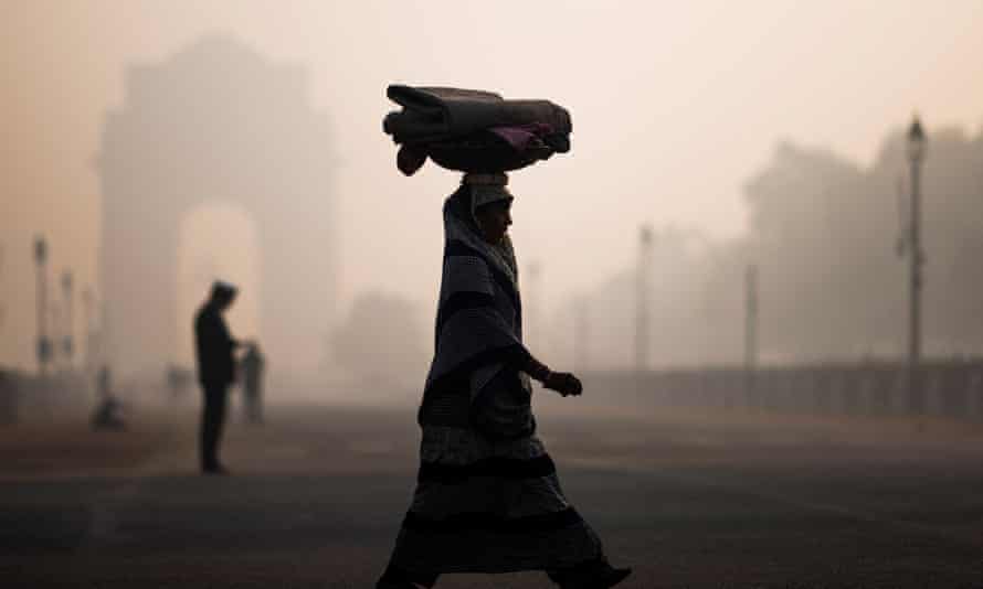
Smoggy conditions in New Delhi
Smoggy conditions in New Delhi. India is worst affected country, with the average citizen dying six years early. Photograph: Jewel Samad/AFP/Getty Images.
Air pollution is cutting short the lives of billions of people by up to six years, according to a new report, making it a far greater killer than smoking, car crashes or HIV/Aids.


Coal burning is the principal culprit, the researchers said, and India is worst affected, with the average citizen dying six years early. China has slashed air pollution in the last seven years, but dirty air is still cutting 2.6 years from its people’s lifespan.

Fossil fuel burning is causing air pollution and the climate crisis, but nations have much greater power to cut dirty air within their own borders. The climate crisis is now also adding to air pollution by driving wildfires, completing a vicious circle, the scientists said.

The team said recent events had illustrated the different futures possible depending on whether governments act or not. Coronavirus lockdowns cut pollution, revealing the Himalayas to some Indian city dwellers, while wildfires in the western US caused serious pollution on the other side of the continent in New York City.

“Air pollution is the greatest external threat to human health on the planet, and that is not widely recognized, or not recognized with the force and vigor that one might expect,” said Prof Michael Greenstone at the University of Chicago. Greenstone and colleagues developed the Air Quality Life Index (AQLI), which converts air pollution levels into their impact on life expectancy.

The average global citizen loses 2.2 years of life with today’s levels of air pollution and, if nothing changes, that adds up to 17bn lost years, Greenstone said. “What else on the planet is causing people to lose 17bn years of life?”

“Furthermore, we’re not just letting it happen, we’re actually causing it,” he said. “The most striking thing is that there are big countries where, effectively, a combination of the government and [societal] norms are choosing to allow people to live really dramatically shorter and sicker lives.” He said switching to cleaner energy and enforcing air quality measures on existing power plants have cut pollution in many countries.

The report estimated the number of additional years of life people would gain if air pollution levels in their country were reduced to World Health Organization guidelines. In India, the figure is 5.9 years – in the north of the country 480 million people breathe pollution that is 10 times higher than anywhere else in the world, the scientists said. Cutting pollution would add 5.4 years in Bangladesh and Nepal, and 3.9 years in Pakistan.

In central and west Africa, the impacts of particulate pollution on life expectancy are comparable to HIV/Aids and malaria, but receive far less attention, the report said. For example, the average person in the Niger delta stands to lose nearly six years of life, with 3.4 years lost by the average Nigerian.

China began a “war against pollution” in 2013 and has reduced levels by 29%. This is adding an average of 1.5 years on to lives, assuming the cuts are sustained, the scientists said, and shows rapid action is possible.

“Coal is the source of the problem in most parts of the world,” said Greenstone. “If these [health] costs were embedded in prices, coal would be uncompetitive in almost all parts of the world.”

Fossil gas is significantly less polluting than coal and Japan said in June that it would offer $10bn in aid for energy decarbonisation projects in southeast Asia, including gas power stations. But gas burning still drives global heating and Christiana Figueres, former UN climate chief, said on Sunday: “Let’s be clear, gas is not an alternative to coal and nor is it a transition fuel. Investments in new gas must stop immediately if carbon neutrality is to be reached by 2050.”

The AQLI report is based on research comparing the death rates of people living in more and less polluted places, with heart and lung problems being the largest source of early deaths. The analysis is based on small particle pollution, but is likely to include the effects of other air pollutants as these all tend to be high in the same locations. The estimates of air pollution around the world were derived from satellite data at 3.7-mile (6km) resolution.

  • The picture on this story was changed on 1 September 2021. The original showed water vapor emerging from cooling towers, which does not contribute to particulate pollution.
  • Related in The Guardian
    Air Pollution Trail Pic
    Revealed: air pollution may be damaging ‘every organ in the body’

If there were ever a time to join us, it is now. Every contribution, however big or small, powers our journalism and sustains our future. Support the Guardian from as little as $1 – it only takes a minute. Thank you.

Ida collapses Mississippi road; kills 2, injures at least 10

Ida collapses Mississippi road; kills 2, injures at least 10


Ten people were injured and two were killed when a highway collapsed in Mississippi

LUCEDALE, Miss. (AP) — Barbara Cochran said she was about to get ready for bed late Monday when she heard a loud crash outside her home in rural southeastern Mississippi. Hurricane Ida had been dumping torrential rain, her husband was already asleep and the home’s air conditioner was humming loudly.

The 83-year-old retired educator said she went onto the porch to see if a big oak tree had fallen, or if an 18-wheeler had slid off the highway down the hill from their home. She didn’t see car lights, so she didn’t think there was a wreck.

About 10 minutes after she went back inside, she heard a second loud crash. Moments later, Cochran heard a third crash. As she was about to call the sheriff’s department, she heard the wail of sirens.

And, she said: “I heard something that sounded like a woman screaming.”

Two people were killed and at least 10 others were injured late Monday when seven vehicles plunged, one after another, into a deep hole where a dark, rural highway collapsed as Hurricane Ida blew through Mississippi, authorities said Tuesday.

Heavy rainfall may have caused the collapse of two-lane Mississippi Highway 26 west of Lucedale, and the drivers may not have seen that the roadway in front of them had disappeared, Mississippi Highway Patrol Cpl. Cal Robertson said. The George County Sheriff’s Department received the first call at about 10:30 p.m.

Cochran told The Associated Press that she didn’t know about the highway collapse or the wrecks until after she woke from a fitful night’s sleep. She said she is praying for the families of those killed or hurt.

“This is such a catastrophe,” Cochran said Tuesday.

Robertson said some of the vehicles ended up stacked on top of each other as they crashed into the abyss, which opened up in a rural area without street lights. Ida dumped as much as 13 inches (33 centimeters) of rain as it blew through Mississippi, the National Weather Service said.

“You can imagine driving at night with heavy rain coming down,” Robertson said. “It’s just nothing but a wall of water, your headlights kind of reflecting back on you.”

State troopers, emergency workers and rescue teams responded to the crash site about 60 miles (96 kilometers) northeast of Biloxi, to find both the east and westbound lanes collapsed. Robertson said the hole removed about 50 to 60 feet (15 to 18 meters) of roadway, and is 20 to 30 feet (6 to 9 meters) deep.

George County Sheriff Keith Havard told the Sun Herald that the sheriff’s department received a 911 call from a man whose car had plunged into the hole.

“He said he was driving and all of a sudden he wasn’t driving anymore,” Havard said. “He didn’t understand what had happened. I can’t imagine anyone would.”

The newspaper reported that 911 dispatchers heard other vehicles crash into the pit.

The vehicles were later lifted out by a crane, leaving some debris at the bottom of the hole. A drone video published by the Sun Herald showed how a raised berm beneath the road washed away, leaving a red-clay scar that runs for hundreds of feet, from a cemetery on one side into a wooded area on the other.

“It is a slide, which means the ground under the roadway and embankment was super-saturated and we can tell right now that’s what caused the slide,” Kelly Castleberry, district engineer for the Mississippi Department of Transportation, told the newspaper.

Jerry Lee, 49, of Lucedale, was pronounced dead at 1:20 a.m., and Kent Brown, 49, of Leakesville, was pronounced dead 10 minutes later, George County Coroner DeeAnn Murrah said.

George County High School said one of its students, a senior, was hospitalized with critical injuries after crashing into the hole. Local schools were closed Tuesday because the collapsed highway created problems for buses and other traffic.

Mississippi southern district Transportation Commissioner Tom King said he didn’t know anything unusual about the soil conditions where the highway caved in.

“We just got bombarded here in south Mississippi with rain,” King told the AP.

King said work crews were checking other highways in areas that received heavy rain from Ida.

Between 3,100 and 5,700 vehicles drive along the stretch of highway on an average day, according to Mississippi Department of Transportation data.

“It’s going to take us a while to redo it and make it right again and make it safe for folks to go over,” King said of the collapsed roadbed.

Mike Dillon is pastor of Crossroads United Pentecostal Church, which is near the crash site. He said he learned about the crashes after he woke up Tuesday and checked a community prayer page online. Like many local residents, he walked to the crash site and prayed.

“We’re a very close-knit community,” Dillon said, “and we’re going to get through this with the help of the Lord.”

Hurricane Ida blasted ashore Sunday as a Category 4 storm, one of the most powerful ever to hit the U.S. mainland. It knocked out power to much of southeastern Louisiana and southern Mississippi, blowing roofs off buildings and causing widespread flooding as it pushed a surge of ocean water that briefly reversed the flow of the Mississippi River.

This story has been corrected to show that Jerry Lee was 49, not 42.

Emily Wagster Pettus reported from Jackson, Mississippi.

One evacuated and the other chose to stay. 2 south Louisiana residents share the horror of Hurricane Ida.

One evacuated and the other chose to stay. 2 south Louisiana residents share the horror of Hurricane Ida.

Marquise Francis, National Reporter & Producer      August 31, 2021


Amber Russo of LaPlace, La., was attending performing arts classes at Louisiana State University last Tuesday, excited to be getting her senior year of college underway. She had no idea that her world would be turned upside down less than a week later, when Hurricane Ida wreaked havoc across the state.

“It was so short notice, because it popped up out of nowhere,” Russo, 22, told Yahoo News. “I had to convince my mom at first to leave. I told her, ‘We’ve got to get the hell out of here.’ … This time last week I was going to college, having theater classes and having voice lessons, and this week none of that is happening.”

On Sunday evening — the 16th anniversary of Hurricane Katrina, which devastated New Orleans and much of the Gulf Coast — Ida made landfall in Louisiana as a Category 4 hurricane. The storm and its 150 mph winds stretched across 45 miles. It destroyed countless homes and businesses and caused so much flooding that boats replaced cars in some parishes.

The entire city of New Orleans lost power Sunday night, and it may take weeks to restore in some areas. Two people died and 10 others were injured after a rain-battered highway collapsed in George County, Miss., late Monday.

But no community suffered more destruction than LaPlace.

LaPlace, the largest city in St. John the Baptist Parish, is located along the east bank of the Mississippi River, with a population of just under 30,000 people. The majority-Black parish was in the direct path of Hurricane Ida, leaving many residents stranded.

“The streets of LaPlace looked like a raging river, all while buildings swayed from the high winds, metal ripped away from rooftops and traffic lights looked like they would fly away into Oz during the catastrophic storm,” Newsweek reported.

Residents wait to be rescued by first responders from floodwaters in LaPlace, La., on Monday.
Residents wait to be rescued by first responders from floodwaters in LaPlace, La., on Monday. (Luke Sharrett/Bloomberg via Getty Images)


Russo, her mom and two brothers are thankful to have gotten out of town. Now they’re more than 400 miles away from home in Hot Springs, Ark., a city they’ve never been to before, after evacuating from their home early Sunday morning. They’re staying in a rented space for now, thankful for two $50 donations they’ve received online that have helped them get by so far.

“It’s been stressful,” Russo said, adding that she’s previously been diagnosed with schizophrenia. She called the situation “scary, leaving us wondering what’s going to happen.”

The Russo family is hoping for the best when they return home this Friday, which Amber said they would do, “power or no power.” A neighbor who stayed in town told Russo that while her family’s backyard shed was destroyed, their home appears to be intact. Russo admits that many others are in a worse predicament than her family, especially those who were unable to flee Ida’s path.

All Sunday evening, Twitter users shared their addresses in desperation for help, many having to retreat into their attics as floodwaters rose 5 feet or higher in some homes. Dozens of messages, with some iteration of “Send help!” or “Help needed!” or “Urgent help!,” were shared like digital SOS alerts on social media to anyone who could offer any type of aid.

“It’s the worst that I’ve seen in the 20 years I’ve been in the parish,” Randal Gaines, a state representative who represents St. Charles and St. John the Baptist parishes, told NBC News Monday. “And we’ve seen several hurricanes.”

A first responder walks through floodwaters left by Hurricane Ida in LaPlace, La., on Aug. 30, 2021.
A first responder walks through floodwaters left by Hurricane Ida in LaPlace, La., on Monday. (Luke Sharrett/Bloomberg via Getty Images)


By Monday morning, Parish President Jaclyn Hotard told the Times-Picayune that there were no known fatalities from “one of the most catastrophic” storms to hit St. John the Baptist Parish. Nearly 800 people were rescued through Monday, according to parish officials.

“We have been tested before, and we overcame,” Hotard said. “Please continue to pray for our community and know that we have all hands and resources on deck.”

While thousands of people evacuated the southern part of Louisiana ahead of the storm, many chose to hunker down. Some did so out of stubbornness, while others stayed because they had nowhere else to go.

Jessica Bowers and her family — including her two children — decided to outlast the hurricane from inside their mobile home in LaPlace. After not evacuating during Katrina and now Ida, Bowers told NBC affiliate KPRC-TV that the family is thankful to be alive.

“Never again,” she said. “Leave, evacuate.”

For those who lived through Katrina, Ida is one big nightmare all over again. But this time the spotlight wasn’t solely on New Orleans and its challenges.

“Don’t forget it isn’t JUST New Orleans that was destroyed,” one person tweeted. “Houma. LaPlace. Franklin. Baton Rouge. And many more. … These cities need attention and help too!”

First responders rescue residents from floodwater left behind by Hurricane Ida in LaPlace, Louisiana, U.S., on Monday, Aug. 30, 2021. [left] Floodwaters left behind by Hurricane Ida in LaPlace, Louisiana, U.S., on Monday, Aug. 30, 2021. [right] (Photo Illustration: Yahoo! News; Photos: Luke Sharrett/Bloomberg via Getty Images (2))


One of the most active people on Twitter sharing the addresses of those in need along with resources was Keva Peters Jr. of St. Rose, La. Despite riding out a “scary and nerve-racking” Sunday night in his own home, he also continued to help others.

“I’m still trying my best to help others even while dealing with my own issues, but disasters like this take the community,” Peters told Yahoo News. “I was younger for Katrina, but I do remember how bad the aftermath was.”

Since Sunday, Peters has been “taking it day by day,” as the small group he is now with is low on water and food, and has no power and limited amounts of money.

“I was in a house with six people during the storm, and we had to hunker down in the stairway,” he said. “The upstairs floors were caving in, and everything on top was going to topple over us. The eye of the storm was about 15 miles west of us. Luckily, we were able to escape to a neighbor’s house after the roof caved in.

“A lot of people are shaken up badly, including myself,” he added. “The smallest sounds make my heart drop now, after going through the storm.”

St. Rose, a community of less than 10,000 people located in the St. Charles Parish along the east bank of the Mississippi River, is currently under a curfew that lasts from 8 p.m. to 5 a.m., as first responders work to clean up the debris and assess damages in the community. Peters says that most people are without cell service, but Wi-Fi still works.

“What we’re going through isn’t unbearable, and we’re hopeful,” he said.

Patricia Henderson stands in the stairway at her home, which lost its roof during Hurricane Ida, on Tuesday in Ponchatoula, La.
Patricia Henderson stands in the stairway at her home, which lost its roof during Hurricane Ida, on Tuesday in Ponchatoula, La. (Sean Rayford/Getty Images)


The devastation of past natural disasters, including Katrina, explains why Peters has been so determined to help others. He noted that many people who rode out the hurricane had no other choice, including himself.

“My mom couldn’t evacuate, so I had to choose between evacuating or staying with her. So of course I stayed, even though our town was under mandatory evacuation,” he said. “Others had no family to go to or no money to spend on leaving. Others who left had dealt with Katrina and didn’t want to experience this again.”

Cover thumbnail photo illustration: Yahoo News; photos: Patrick T. Fallon/AFP via Getty Images (2)

‘It will be a challenge to come back from this’: Wildfire threatens to forever change clear blue waters of Lake Tahoe

‘It will be a challenge to come back from this’: Wildfire threatens to forever change clear blue waters of Lake Tahoe


The raging wildfire that is encroaching upon Lake Tahoe threatens to mar the pristine alpine lake that draws approximately 15 million visitors a year to its cobalt waters and sandy beaches, remote mountain trails and world-class ski resorts.

The Caldor Fire in California grew to more than 191,000 acres Tuesday, prompting the evacuation of 22,000 residents in South Lake Tahoe and the partial shutdown of casinos next door in Stateline, Nevada.

Beyond the immediate concern for public safety and the thousands of homes at risk is the threat fire poses to the clarity of and scenery around the world-renowned lake.

While wildfires have wreaked devastation across the West in recent years, it’s hard to imagine a more unsettling scenario than fire bearing down on Lake Tahoe, which Mark Twain described as “the fairest picture the whole earth affords.”

The lake straddles the California-Nevada line high in the Sierra Nevada. The top end is about 35 miles south of Reno and the lower end, which the fire is threatening, is about 100 miles east of Sacramento.

“Lake Tahoe is one of the more unique gems of lakes on the planet,” said Sudeep Chandra, a biology professor and director of the Global Water Center at the University of Nevada, Reno.

At more than 1,600 feet deep it is among the largest lakes in the country. Tahoe is about 22 miles long with more than 70 miles of shore, some of which is undeveloped and protected for outdoor recreation, and some of which is tightly packed with housing, gift shops and towering hotel casinos.

Caldor Fire:Roads packed after South Lake Tahoe ordered to evacuate; all national forests in California closed due to wildfires

A sad irony: Wildfires are burning up trees meant to fight climate change: ‘It’s definitely not working’

“It has a very high transparency,” Chandra said of the famed waters. “You can see almost 100 feet below the surface. It is one of the deepest lakes in the world. From a cultural viewpoint, it is important for the native peoples. The Washoe Tribe lived in the basin. And now it is important for recreation and the local economy.”

A fire burning to the shores of the lake threatens that famous clarity.

South Lake Tahoe, a California city on the south shore, is the most populous area within the basin, and is the area the Caldor Fire is encroaching upon as it moves northward.

Tahoe is known for year-round activities.

The Nevada side attracts people with its casinos. The four on the south end of the lake — Harrah’s Lake Tahoe, Harvey’s, Hard Rock Lake Tahoe and Montbleu Casino Resort — were limiting gambling Monday, with evacuation orders just across the state line in neighboring South Lake Tahoe and many workers needing to tend to affairs at home.

More: Escape from South Lake Tahoe: Evacuees seek shelter from Caldor Fire in Northern Nevada

Caldor Fire updates: Highway 50 packed as thousands flee South Lake Tahoe

Warmer months bring throngs of people seeking Tahoe’s beaches, hiking and biking trails, boating and a variety of water sports such as kayaking and paddle boarding. Among the areas evacuated Monday were the famed Emerald Bay as well as the Tahoe Keys Marina.

Winter brings travelers seeking deep snow at about a dozen ski resorts around the lake, some of which offer views of the deep blue water from the slopes.

Already the flames have enveloped hillsides around Sierra-at-Tahoe Resort. Webcam footage appeared to show firefighters using a lift at Kirkwood Mountain Resort in their fight to keep the flames at bay.

Heavenly Ski Resort straddles the state line, with lifts and trails in both states. Monday’s evacuation orders included the area around its California operations.

Fire comes during busy season

The end of summer is usually among the busiest tourism periods for Lake Tahoe, and tourism is the key industry for the region.

The entire lake basin’s annual economy is estimated at $5 billion, with visitor services making up about 62% of that, said Carol Chaplin, president and CEO of the Lake Tahoe Visitors Authority.

But occupancy for Tahoe-area hotels already fell to below 30% in the past week because smoke from the fires drove visitors away. That was before officials asked travelers to avoid the area.

Now many hotels either are housing evacuees or emergency workers in town because of the fire, Chaplin said.

Normally hotels would be between 80-90% full this time of year heading into Labor Day.

Tahoe attracts most visitors from the San Francisco Bay Area, but increasingly sees visitors from across the United States and, prior to COVID-19 travel restrictions, international markets.

“We are an international destination,” said Chaplin, who also is a trustee of the Reno-Tahoe International Airport. “Our largest (international) markets are the United Kingdom, Australia, but we were starting to see India, China, South America.”

Tahoe was more popular than usual amid the COVID-19 pandemic the past two summers, even with limited international travel.

“We didn’t feel that because of the additional interest in outdoor recreation areas during COVID,” Chaplin said, adding that lodging and the airport have operated above 2019 levels during the pandemic. “People are really getting out there and using the trails like never before.”

Chaplin said her immediate thoughts were with people who already had lost homes to the fire, as well as those still in the fire’s path. But the long-term impact to the travel industry and all the people it employs also gives her concern.

Choking on smoke: South Lake Tahoe, usually bustling now, is empty

Many travelers to Lake Tahoe from California drive from Sacramento on U.S. 50, several miles of which were overrun by the Caldor Fire.

“The approach will be different,” Chaplin said of road trips to the area once the fire is under control. “It will be a challenge to come back from this.”

Water clarity makes lake famous

Tahoe is known for its clarity, with Twain writing in his 1872 book “Roughing It” that drifting on the lake in a rowboat was akin to floating from a balloon because the water was so transparent.

And while development and pollution have clouded the water somewhat since that time, the lake is still clear enough to see to depths of more than 62 feet on average, according to the latest report from the Tahoe Regional Planning Agency, which monitors environmental quality in the basin. The best measurements taken last year afforded 80 feet of visibility.

“It is really a national treasure,” said Sean McKenna, executive director of the Division of Hydrologic Sciences at the Desert Research Institute in Reno. “It has stayed that way through a very concerted effort and management practices.”

Maintaining the lake’s clarity has been a concern since the 1960s, and the municipalities around the lake have taken extra precautions, such as pumping all of their wastewater outside of the lake’s basin for treatment, to ensure the water stays clear, he said.

The Tahoe Regional Planning Agency also enforces a variety of restrictions on development, often to the chagrin of home owners and developers, with the intent on keeping runoff out of the lake and maintaining Tahoe’s clarity.

The focus lately is on storm water entering the lake, carrying with it sediment and nutrients that can affect lake clarity.

“Something we worry about a lot is the post-fire hydrologic effects,” McKenna said. “The soils become less permeable, so that could lead to more runoff and debris flows, more sediment. A severe fire going through there will change all the year-round activities significantly.”

What researchers don’t know is whether the effects will last for a short term or continue for years.

In 2007, the Angora Fire burned just over 3,000 acres in the Tahoe basin, destroying 254 homes. That fire’s impacts on the watershed were studied and found to be minimal.

“It is safe to say it is not an easy fix and will take resources and energy above and beyond what we have contributed to restoration to date,” Chandra said.

Ecologically speaking, Tahoe was home to Lahontan cutthroat trout, which wildlife officials are reintroducing to waterways in the region, and remains home to 10 endemic invertebrates, Chandra said.

The smoke from wildfires alone, which have been hammering the region for weeks, can affect the lake by “reorganizing” fisheries and aquatic plants, Chandra said.

But the other concern is that a wildfire in the basin will leave a burn scar, allowing more runoff into the lake that can bring more nutrients and soil, clouding the water and providing nutrients for algae that can further affect the clarity.

“While these are challenging times certainly for the people of Lake Tahoe, the lake also has had the remarkable ability to recover over time,” Chandra said, citing deforestation in the 1800s that increased sediment in the lake.

That problem was largely resolved by the 1950s when the forest had regrown, he said.

“We are facing the same situation today, a catastrophic and in this case unintended event is occurring that has the potential to change the long term clarity in the lake,” Chandra said.

“The science-supported management activities that we need to plan after this fire can help us understand the short- and long-term impacts to the lake’s fragile clarity and — where to go next.”

Firefighters say the raging Caldor Fire that sparked evacuations in the Lake Tahoe region may not be fully contained until mid-September

Firefighters say the raging Caldor Fire that sparked evacuations in the Lake Tahoe region may not be fully contained until mid-September

  • Firefighters say the Caldor Fire in Northern California will take another two weeks to contain.
  • The blaze has already consumed over 191,000 acres and destroyed over 600 buildings.
  • Five people – three first responders and two civilians – have been injured in the fire.

Firefighters say the massive Caldor Fire in Northern California will likely take another two weeks to contain, according to the California Department of Forestry and Fire Protection.

The wildfire has already consumed over 191,000 acres and destroyed over 600 buildings, fire officials said Tuesday.

Over 33,000 structures are threatened by the blaze that has prompted a series of evacuations orders and warnings in the area and caused gridlock on nearby highways as residents fled.

Five people – three first responders and two civilians – have been injured in the fire.

Cal Fire’s hourly updates on the fire’s trajectory and evacuation orders have warned there is a “potential threat to life and/or property.

What happens to animals during wildfires

It’s hard to imagine any good could come from a wildfire. But for some plants and animals, there are more benefits to wildfires than meets the eye.

A video shared on social media on August 27 shows the blaze casting an eerie, orange haze over the Lake Tahoe area.

The situation comes as firefighters in California face multiple active wildfires amid an ongoing drought. The Dixie Fire, currently the largest active wildfire in the state, grew to over 765,000 acres since it began in mid-July, Cal Fire said.

This story is developing. Please check back for updates.

To Save Lake Tahoe, They Spared No Expense. The Fire Came Over the Ridge Anyway.

To Save Lake Tahoe, They Spared No Expense. The Fire Came Over the Ridge Anyway.

San Marcos firefighters work to save a burning cabin in Strawberry, Calif. on Aug. 30, 2021. (Max Whittaker/The New York Times)


SOUTH LAKE TAHOE, Calif. — They sent thousands of firefighters, 25 helicopters and an arsenal of more than 400 fire engines and 70 water trucks. Yet the fire still advanced.

They dropped retardant chemicals through an ash-filled sky and bulldozed trees and brush to slow the march of the flames through the steep and rugged terrain of the Sierra Nevada. Yet the fire still advanced.

Bursting across a granite ridge into the Lake Tahoe basin, the Caldor fire now threatens tens of thousands of homes and hotels that ring the lake.

On Tuesday, the smoke-choked streets of South Lake Tahoe, the most populous city on the lake, were deserted, save for police patrol cars and an occasional convoy of fire vehicles. Thousands of residents and tourists had been evacuated the day before.

The lake, renowned for its bright blue hues and the evergreen forests that surround it, was smothered in a slate of sickly orange-gray haze. On the Nevada side of the border, which has not yet been evacuated, one industry was still limping along: A trickle of gamblers sat at slot machines to the whooshing sound of large air purifiers that attempted to keep out the pungent smoke. The air quality index was nearing 500, a level considered hazardous.

Battling the Caldor fire has been humbling and harrowing for California firefighters. Experts believe the challenge is a cautionary tale for future megafires in the West and lays bare a certain futility in trying to fully control the most aggressive wildfires.

“No matter how many people you have out on these fires, it’s not a large enough workforce to put the fire out,” said Malcolm North, a fire expert with the U.S. Forest Service and a professor at the University of California, Davis.

“You can save particular areas or particular homes,” North said. “But the fire is pretty much going to do what it’s going to do until the weather shifts.”

On Monday, propelled by strong winds, the fire crested a granite ridge that officials had hoped would serve as a natural barrier. Embers leapfrogged past firefighting crews and descended toward the valley floor just miles from South Lake Tahoe. By early Tuesday, the fire had taken hold in the Tahoe basin. Stands of pine ignited by flying embers were fully engulfed in flames, casting a bright orange glow into the night sky.

It was only the second time, officials said, that a wildfire that began on the western slopes of the Sierra Nevada crossed into the eastern side. The first was also this summer: the Dixie fire, the second largest in California history. No deaths have been reported in either fire.

The authorities say about 27,000 firefighters were battling blazes across the country, about 15,000 of them in California. All national forests in California will be closed by Tuesday night. Hundreds of soldiers and airmen and several military aircraft have been sent by the National Guard. But the resources are no match for the ferocious blazes, which continue to outpace firefighters and explode across the state.

The blazes in Sierra forests have exposed the domino effects of climate change on firefighting challenges: Frequent heat waves and overall higher temperatures have desiccated West Coast flora, making it more vulnerable to large fires. Droughts have weakened trees, encouraging insect infestations that have contributed to the deaths of close to 150 million trees. This creates more fuel for fires.

Scientists say there is also a correlation between global warming and the increased wind conditions that have fanned fierce wildfires across the state. And they point to a need for better forest management, thinning out some of the thickest woods.

What characterizes the megafires of recent years, experts said, is their tendency to launch embers far ahead of the main fire front — sometimes by miles — and for the embers to land on parched terrain that is instantly combustible. This can rapidly expand the perimeter of the fire, which hops over one of the main containment tools: the bulldozed areas, known as fire breaks, that create a line of containment.

The Tubbs fire in October 2017 jumped over what would normally be considered a formidable fire break — a six-lane freeway — and went on to incinerate 1,200 homes in the residential community of Coffey Park.

“These spot fires are causing a lot of havoc,” said Craig Clements, a professor of meteorology and the director of the Wildfire Interdisciplinary Research Center at San Jose State University, a group that is modeling the spread of the Caldor fire.

“There’s just fire all around,” Clements added, “and that makes it very difficult to suppress.” As a measure of how combustible the landscape has become, other scientists have calculated that embers have a 90% chance of becoming spot fires once they land.

The chaotic way these megafires spread was on display in the hills above South Lake Tahoe on Monday. Kyle Hukkanen was leading a crew of 12 inmate firefighters armed with axes, shovels and chain saws. They bounded down a steep hillside of granite boulders and evergreen trees until they reached a spot where wisps of smoke were rising from the ground.

They dug and sprayed the smoldering fire with water before ascending back to their idling truck. “This is not good,” Hukkanen said as gusts of wind fed the spot fire on the hillsides. The radio crackled with reports of spotting farther down the mountain toward South Lake Tahoe, and Hukkanen and his crew disappeared down a smoke-shrouded road.

Fire specialists say some firefighting tools are appropriate on a smaller scale but outmatched by the huge fires of recent years.

In the hills and gullies where the Caldor fire has burned 190,000 acres over the past two weeks, helicopters dropped large buckets of water — thousands of gallons at a time — but they hardly seemed a match.

“That’s great for protecting a neighborhood, but when you think about the size of a 750,000-acre fire, that’s nothing,” North, the U.S. Forest Service expert, said of dropping water or retardant in large swaths of forest.

He and others added that the Sisyphean task of fire containment pointed to a desperate need for better mitigation.

Controlled burns that embrace Indigenous methods to use “good” fire to fight destructive megafires has become an increasingly accepted method in recent years, but experts say that the state has a lot of catching up to do.

Until then, attempts to suppress fire are inevitably required to save lives and property. In the past year, California spent more than $1 billion on emergency fire suppression efforts but slashed its prevention budget. This year’s budget includes more than $500 million for fire prevention, Gov. Gavin Newsom said in April.

Still, resources remain strained. The U.S. Forest Service has struggled to retain federal firefighters, who earn around half of their state counterparts’ pay at Cal Fire. When the Caldor fire ballooned to 6,500 acres in mid-August, just 242 firefighters had been assigned to it. Eventually, hundreds more were redeployed from the Dixie fire, which has so far razed more than 800,000 acres and was still less than half contained by Tuesday morning.

On the receiving end of the worsening fires are the residents who wonder where, if anywhere, will be safe from wildfire.

Among the evacuees from South Lake Tahoe on Monday were Darren Cobrae, a real estate investor, and his partner, Stephanie Cothern, who was driving the couple’s car toward the Nevada state line.

Inside were bags of clothing, two large parrots and three dogs, Banana, Freddy and Copper.

Cobrae said he moved to South Lake Tahoe from Southern California, where his home was nearly burned in a wildfire in 2007.

“I figured I would be safe in this city,” Cobrae said. “And now this,” he said, pointing to a sky thickening with smoke.