Putin warns the United States of Cold War-style missile crisis
Guy Faulconbridge and Dmitry Antonov – July 28, 2024
Russian President Putin chairs a meeting in Moscow
MOSCOW (Reuters) -Russian President Vladimir Putin on Sunday warned the United States that if Washington deployed long-range missiles in Germany then Russia would station similar missiles in striking distance of the West.
The United States said on July 10 that it would start deploying long-range missiles in Germany from 2026 in preparation for a longer-term deployment that will include SM-6, Tomahawk cruise missiles and developmental hypersonic weapons.
In a speech to sailors from Russia, China, Algeria and India to mark Russian navy day in the former imperial capital of St Petersburg, Putin warned the United States that it risked triggering a Cold War-style missile crisis with the move.
“The flight time to targets on our territory of such missiles, which in the future may be equipped with nuclear warheads, will be about 10 minutes,” Putin said.
“We will take mirror measures to deploy, taking into account the actions of the United States, its satellites in Europe and in other regions of the world.”
Putin, who sent his army into Ukraine in 2022, casts the war as part of a historic struggle with the West, which he says humiliated Russia after Soviet Union fell in 1991 by encroaching on what he considers Moscow’s sphere of influence.
Ukraine and the West say Putin is engaged in an imperial-style land grab. They have vowed to defeat Russia, which currently controls about 18% of Ukraine, including Crimea, and parts of four regions in eastern Ukraine.
Russia says the lands, once part of the Russian empire, are now again part of Russia and that they will never be given back.
COLD WAR?
Russian and U.S. diplomats say their diplomatic relations are worse even that during the 1962 Cuban Missile Crisis, and both Moscow and Washington have urged de-escalation while both have made steps towards escalation.
Putin said that the United States was stoking tensions and had transferred Typhon missile systems to Denmark and the Philippines, and compared the U.S. plans to the NATO decision to deploy Pershing II launchers in Western Europe in 1979.
The Soviet leadership, including General Secretary Yuri Andropov, feared Pershing II deployments were part of an elaborate U.S.-led plan to decapitate the Soviet Union by taking out its political and military leadership.
“This situation is reminiscent of the events of the Cold War related to the deployment of American medium–range Pershing missiles in Europe,” Putin said.
The Pershing II, designed to deliver a variable yield nuclear warhead, was deployed to West Germany in 1983.
In 1983, the ailing Andropov and the KGB interpreted a series of U.S. moves including the Pershing II deployment and a major NATO exercise as signs the West was about to launch a pre-emptive strike on the Soviet Union.
Putin repeated an earlier warning that Russia could resume production of intermediate and shorter range nuclear-capable missiles and then consider where to deploy them after the United States brought similar missiles to Europe and Asia.
(Writing by Guy Faulconbridge; editing by David Evans)
Donald Trump Tells Christians They ‘Won’t Have to Vote Anymore’ if He’s Elected to Another Term
Charlotte Phillipp – July 27, 2024
Kamala Harris’ campaign team later called the former president’s comments a “vow to end democracy”
Joe Raedle/GettyDonald Trump speaks during a Turning Point USA Believers Summit conference at the Palm Beach Convention Center on July 26, 2024.
Former President Donald Trump made waves after urging his Christian followers to vote for him in the upcoming presidential election “just this time” — and saying that they “won’t have to do it anymore” if he wins.
During an event on Friday, July 26, hosted by the conservative Christian organization Turning Point Action, Trump, 78, addressed the crowd and implied that if he were to be voted in, “everything” would be “fixed,” according to multiple sources, including Rolling Stoneand The Hill.
“Christians, get out and vote, just this time,” Trump said as the crowd in West Palm Beach, Fla., cheered, per the outlets.
“You won’t have to do it anymore,” he said. “Four more years, you know what, it will be fixed, it will be fine. You won’t have to vote anymore, my beautiful Christians.”
Brandon Bell/GettyPresident Donald Trump speaks to attendees during his campaign rally on July 24, 2024 in Charlotte, N.C.
“I love you Christians. I’m a Christian. I love you, get out, you gotta get out and vote. In four years, you don’t have to vote again, we’ll have it fixed so good you’re not going to have to vote,” Trump continued.
At the same event, Trump also claimed that he would “once again appoint rock-solid conservative judges who will protect religious liberty,” per Rolling Stone.
In a statement shared by Vice President Kamala Harris‘ campaign team on Saturday concerning what they called “Trump’s vow to end democracy,” Harris for President spokesperson James Singer said: “When Vice President Harris says this election is about freedom, she means it.”
“Our democracy is under assault by criminal Donald Trump: After the last election Trump lost, he sent a mob to overturn the results,” Singer continued.
“This campaign, he has promised violence if he loses, the end of our elections if he wins, and the termination of the Constitution to empower him to be a dictator to enact his dangerous Project 2025 agenda on America,” he added.
Want to earn extra money through a side hustle? Here’s why 1 in 3 Americans do it.
Betty Lin-Fisher, USA TODAY – July 27, 2024
The gig economy is still big in the U.S. and growing.
More than a third (36%) of U.S. adults are working a side hustle – earning money in addition to their main source of income – according to a new Bankrate survey. They are earning more than they did last year, with the average side hustler making $891 a month, up from $810 last year.
Though the number of respondents who said they had a side hustle was down slightly from last year’s 39%, it is way up from 2019 when Bankrate first started surveying respondents about their extra gigs, Ted Rossman, Bankrate senior industry analyst, told USA TODAY. By comparison, in 2019, 19% of respondents said they had a side hustle.
“More people are side hustling because of inflation and because of high interest rates,” Rossman said. “Technology has made it easier as well. A lot of people are doing work from home and things online and via various mobile apps.”
Updated numbers are not widely available, but in 2018, Marketdata estimated the gig and side hustle market at $2.58 trillion. That year, analysts thought 36% of the U.S. workforce of 160 million already had an extra gig job. That number was forecasted to grow by more than 50% by 2027 to 83 million Americans working a side hustle.
And then Covid happened.
More than a third of Americans, or 36%, are working a side hustle, such as dog walking, according to a new Bankrate survey.
The number of people who picked up a side hustle spiked during the pandemic, said Bryce Colburn, lead editor covering small businesses for USA TODAY/Blueprint, a personal finance content partner to USA TODAY.
Colburn, whose journalists have written several stories about side hustles, said that while he can’t say the side hustle industry grew directly because of COVID-19, the spike in the number of people who had side hustles during and after the pandemic is pretty clear.
“Remote work has definitely been a huge factor in the growing of side hustles,” Colburn said. “We now have technology to do remote work, which then means that now if you’re home, you also can work on other things.”
Who is doing side hustles?
All ages are taking on side hustles, but more millennials and Gen Zers seem to have side hustles, Colburn said.
Colburn’s observation matches results from Bankrate’s study: Gen Zers (ages 18-27) had the highest number of people with a side hustle (48%) compared with millennials (ages 28-43) with 44%. Among Gen Xers (ages 44-59), 33% had an extra job, while 23% of baby boomers (ages 60-78) said they had a side gig.
Parents of children under 18 are more likely to have a side hustle (45%) than adults without children (36%) or those with adult children (28%), according to the survey.
Some workers may even be doing their side hustle during their remote full-time job, Colbun said.
Here’s some more highlights from Bankrate’s study:
More people started side hustles after 2022: More than half or 52% of side hustlers started less than two years ago.
Side hustlers spend their money differently: 37% use some of their money from gigs on discretionary spending; 36% use the extra cash for day-to-day expenses; 31% put some money into savings; and 20% use the income to pay down debt.
Side hustling isn’t temporary: 32% of respondents think they’ll always need an extra job to pay the bills.
How much are people making from side hustles?
Nearly two-thirds of side hustlers, or 63% in the Bankrate survey, said they are making more than $100 a month, and more than 1 in 4 respondents, or 28%, are making more than $500 a month.
Younger generations and men are more likely to have a side hustle, and make more. Millennial side hustlers report making an average $1,129 a month, and Gen Zers make $958. Gen Xers make $751 and baby boomers make $561 a month.
The gender pay gap is also alive in the gig economy: Only a slightly higher percentage of men (38%) have side hustles compared with women (33%), but men make an average of $1,034 a month, while women average $735 a month.
A food delivery worker looks at his mobile phone while carrying items to be delivered at a mall in Beijing on July 10, 2024.
Why are people taking side hustle jobs?
High inflation and rising housing costs, in addition to regular monthly bills and the desire to travel and save money, are causing more people to look to side hustles, Rossman said. “Americans are still finding that one job isn’t enough. The cost of living has risen sharply in recent years,” he said.
But Rossman said he also takes with a grain of salt the study statistic saying 32% of people with a side hustle felt they’d always need it to make ends meet.
“Most of these people are relatively new to it, and yet they’re saying they think they need to do it forever,” he said, since more than half have had a side hustle for two years or less. “Maybe things won’t be as bad as people fear.”
Still, “it’s very much a spending story,” he said. “Last year, it was all about day-to-day expense … “This year, it’s more fun spending and ‘I’m going to side hustle to take a nice vacation or splurge on some electronics’ or something like that.”
Colburn said his reporters were surprised to find that while many side hustlers said they were doing the extra job because they needed the money, “50% of people say that they’re doing it for fun and not for money.”
What are some of the best side or most popular gigs?
Side jobs that involve e-commerce, such as eBay or Etsy or using social media to funnel people to an e-commerce platform are popular, Colburn said.
Meanwhile, some of the easiest side hustles, according to Blueprint, are house sitting, dog walking, freelance work and grocery delivery. Blueprint also suggested some side jobs to avoid, such as online survey taker, ride-share driver and mystery shopper, saying they may not pay enough for the time invested.
A lot of people don’t realize that they have to pay taxes on anything more than $400 earned from a second job or that a successful side gig could push you into a higher tax bracket, he said.
Rossman said he believes the number of people doing side hustles will continue to grow, especially as the workforce continues to change and people either choose to job-hop or can’t maintain job stability.
Some people may also turn their side hustle into a passion project or even their next full-time job, he said.
Rossman gave a final bit of advice: if you are going to do a side hustle, walk before you run.
“I think a side hustle is a great way to drum up some extra money, maybe pay off credit card debt,” he said. “But be wary of things that require a big upfront investment. Sometimes they can be an outright scam … other times it’s maybe a multilevel marketing thing where you have to stock up on a bunch of inventory.
“Explore it first, take it for a test drive … prove out the concept before you dive headlong into it.”
Betty Lin-Fisher is a consumer reporter for USA TODAY.
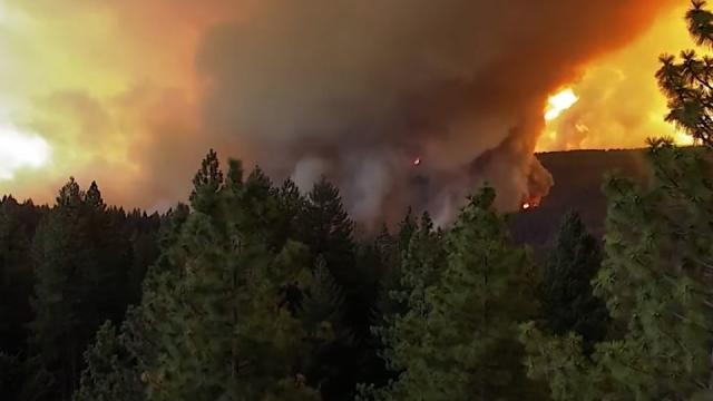
Firefighters get some help from cooler temperatures after California’s largest wildfire explodes
Nic Coury and Olga R. Rodriguez – July 27, 2024
Flames leap above fire vehicles as the Park Fire jumps Highway 36 near Paynes Creek in Tehama County, Calif., Friday, July 26, 2024. (AP Photo/Noah Berger)ASSOCIATED PRESSGrant Douglas pauses to drink water while evacuating as the Park Fire jumps Highway 36 near Paynes Creek in Tehama County, Calif., Friday, July 26, 2024. (AP Photo/Noah Berger)ASSOCIATED PRESSGrant Douglas pauses to drink water while evacuating as the Park Fire jumps Highway 36 near Paynes Creek in Tehama County, Calif., on Friday, July 26, 2024. (AP Photo/Noah Berger)ASSOCIATED PRESSDamage is seen after a wildfire in Jasper, Alberta, Friday July 26, 2024. (Amber Bracken/The Canadian Press via AP)A vehicle drives past the spreading River Fire Thursday, July 25, 2024, near Myrtle, Idaho, before U.S. Highway 12 was closed. Lightning strikes have sparked fast-moving wildfires in Idaho, prompting the evacuation of multiple communities. (August Frank/Lewiston Tribune via AP)Flames consume a vehicle as the Park Fire jburns in Tehama County, Calif., on Friday, July 26, 2024. (AP Photo/Noah Berger)Flames burn as the Park Fire jumps Highway 36 near Paynes Creek in Tehama County, Calif., on Friday, July 26, 2024. (AP Photo/Noah Berger)Flames consume structures as the Park Fire burns in Tehama County, Calif., on Friday, July 26, 2024. (AP Photo/Noah Berger)A resident turns around while trying to evacuate as the Park Fire jumps Highway 36 near Paynes Creek in Tehama County, Calif., on Friday, July 26, 2024. (AP Photo/Noah Berger)Flames leap above fire vehicles as the Park Fire jumps Highway 36 near Paynes Creek in Tehama County, Calif., Friday, July 26, 2024. (AP Photo/Noah Berger)
FOREST RANCH, Calif. (AP) — Thousands of firefighters battling a wildfire in northern California received some help from the weather Saturday, just hours after the blaze exploded in size, scorching an area greater than the size of Los Angeles. The blaze was one of several tearing through the western United States and Canada, fueled by wind and heat.
Cooler temperatures and an increase in humidity on Saturday could help slow the Park Fire, the largest blaze so far this year in California. The blaze’s intensity and dramatic spread led fire officials to make unwelcome comparisons to the monstrous Camp Fire. That fire burned out of control in nearby Paradise in 2018, killing 85 people and torching 11,000 homes.
And Paradise again was near the danger zone. The entire town was under an evacuation warning Saturday, one of several communities in Butte County. Evacuation orders were also issued in Plumas, Tehama and Shasta counties. An evacuation warning calls for people to prepare to evacuate and await instructions. An evacuation order means to leave immediately.
Temperatures are expected to be cooler than average through the middle of next week, but “that doesn’t mean that fires that are existing will go away,” said Marc Chenard, a meteorologist at the National Weather Service Weather Prediction Center in College Park, Maryland.
The blaze has scorched 540 square miles (1,409 square kilometers) as of Saturday with no containment. Los Angeles covers roughly 503 square miles (1,320 square kilometers). The blaze was moving north and east after igniting Wednesday, when authorities said a man pushed a burning car into a gully in Chico and then calmly blended in with others fleeing the scene.
Ronnie Dean Stout, 42, of Chico, was arrested early Thursday in connection with the blaze and held without bail pending a Monday arraignment, officials said. There was no reply to an email to the district attorney asking whether the suspect had legal representation or someone who could comment on his behalf.
Cal Fire incident commander Billy See said at a briefing on Saturday that the blaze had been advancing 8 square miles (21 square kilometers) per hour since its inception. But there was cautious optimism as weather conditions slowed the fire’s advance in some areas, and firefighters were able to plan and deploy additional personnel. Nearly 2,500 firefighters were battling the blaze, aided by 16 helicopters and numerous air tankers.
“Today we’ve got almost three times the personnel we had yesterday morning,” he said. “We still don’t have enough.”
He advised his crews to be aggressive, stay safe and take advantage of what likely are the best conditions they will experience in coming days.
Communities elsewhere in the U.S. West and Canada also were under siege Saturday from fast-moving flames.
More than 110 active fires covering 2,800 square miles (7,250 square kilometers) were burning in the U.S. on Friday, according to the National Interagency Fire Center. Some were caused by the weather, with climate change increasing the frequency of lightning strikes as the region endures record heat and bone-dry conditions.
In Chico, California, Carli Parker is one of hundreds who fled their homes as the Park Fire pushed close. Parker decided to leave her Forest Ranch residence with her family when the fire began burning across the street. She has previously been forced out of two homes by fire, and she said she had little hope that her residence would remain unscathed.
“I think I felt like I was in danger because the police had come to our house because we had signed up for early evacuation warnings, and they were running to their vehicle after telling us that we need to self-evacuate and they wouldn’t come back,” said Parker, a mother of five.
Amanda Brown, who lives in the same community where Stout was arrested, said she was stunned that someone would set a fire in a region where the memories of the devastation in Paradise are still fresh.
“That anyone could deliberately put our community through that again is incredibly cruel. I don’t understand it,” said the 61-year-old Brown, who’s about a mile (1.6 kilometers) from the fire but had not been ordered to evacuate.
Elsewhere, fire crews were making progress on another complex of fires burning in the Plumas National Forest near the California-Nevada line, said Forest Service spokesperson Adrienne Freeman. Traffic was backed up for miles near the border on a portion of the main highway linking Los Angeles and Las Vegas, as crews continued Saturday to battle a fire that started a day before when a truck carrying lithium-ion batteries crashed and turned onto its side.
The most damage so far has been to the Canadian Rockies’ Jasper National Park, where a fast-moving wildfire forced 25,000 people to flee and devastated the park’s namesake town, a World Heritage site. Authorities there said cool and wet weather was helping crews battle the wildfires. This comes after Parks Canada said 358 of the 1113 structures in the town of Jasper had been destroyed.
In eastern Washington state, crews late Friday stopped the forward progress of a fire near the community of Tyler that had destroyed three homes and five outbuildings, the Washington Department of Natural Resources said Saturday. The South Columbia Basin fire burned timber and grasses, and crews continued work on containment lines along the fire perimeter.
Two fires in eastern Oregon, including the Durkee and Cow Valley blazes, had burned about 660 square miles (1,709 square kilometers). Oregon Gov. Tina Kotek late Friday expressed condolences to the family of a pilot of a single-engine air tanker that had gone down in forested terrain while fighting a separate fire near the town of Seneca and the Malheur National Forest.
In Idaho, lightning strikes sparked fast-moving wildfires and the evacuation of multiple communities. The fires were burning on about 31 square miles (80 square kilometers) Friday afternoon. Juliaetta, about 27 miles (43 kilometers) southeast of the University of Idaho’s campus in Moscow, was evacuated Thursday just ahead of roaring fires, as were several other communities.
Rodriguez reported from San Francisco. Associated Press writers Rebecca Boone, John Antczak, Rio Yamat, David Sharp, Holly Ramer, Sarah Brumfield, Claire Rush, Terry Chea, Scott Sonner, Martha Bellisle and Amy Hanson contributed to this report.
California’s largest wildfire of the year has burned an area larger than the size of the city of Los Angeles,destroyed dozens of buildings and forced thousands of residents to flee their homes as wildfires wreak havoc in the Western United States.Meanwhile, homes and businesses in a popular Canadian resort town were incinerated as a wildfire continued to roar through the area. Here’s the latest:
• California’s Park Fire now state’s 8th largest: As the Park Fire exploded across parts of Butte and Tehama counties, north of Sacramento, California, it scorched 134 buildings and threatened another 4,200. The fast moving blaze has burned more than 307,000 acres, or about 480 square miles, making it the eighth largest wildfire in recorded state history. More than 2,400 firefighters are working to slow the fire’s progress as it remains 0% contained, according to Cal Fire.
• California governor declares state of emergency: Gov. Gavin Newsom declared a state of emergency for both counties Friday. The state also secured a federal grant to ensure there are enough resources to fight the blaze. The fire is advancing at 4,000 to 5,000 acres per hour, Billy See, incident commander for Cal Fire, said Friday. With winds forecast to die down overnight and higher humidity moving into the area, See believes firefighters will have a better chance to slow the fire down.
• A man is accused of igniting Park Fire: A 42-year-old man, identified as Ronnie Dean Stout II, was arrested on suspicion of pushing a burning car 60 feet into a gully, “spreading flames that caused the Park Fire,” authorities said. The DA says the man was seen “calmly leaving the area by blending in with the other citizens who were in the area and fleeing the rapidly evolving fire.” Stout, who has not retained an attorney, will likely face an arson charge, the DA’s office told CNN.
• Pilot dies while fighting Oregon fire: A firefighting pilot was found dead in a single-engine air tanker on Friday after going missing the night before while working in the vicinity of the 219-square-mile Falls Fire burning in the Malheur National Forest, according to officials. The fire, which was 55% contained as of Saturday morning, is among a number of large wildfires burning across Oregon. The largest active wildfire in the state is the Durkee Fire, which has scorched about 451 square miles and was 27% contained as of Saturday morning.
• Fire wipes out many of a Canadian town’s buildings: A fast-moving wildfire sent thousands of visitors and residents fleeing the town of Jasper in Alberta, where flames devastated an estimated 30% of the town’s structures. Officials say the losses are significant, and Prime Minister Justin Trudeau has deployed federal support to help battle the blaze. Cool temperatures are expected to calm fire behavior, which will help the 154 firefighters in Jasper fight the blaze, Jasper National Park said on Facebook Friday night. High winds, however, could increase fire activity.
• 96 large wildfires burning nationwide: Triple-digit heat and dry conditions across the West this week have made conditions poor for firefighters actively fighting to contain the dozens of wildfires burning nationwide, including 37 in Oregon and 14 in California. “Elevated to critical fire weather conditions will persist through the weekend across the Western U.S. Isolated dry thunderstorms could lead to new fire starts over portions of the northern Rockies,” the National Weather Service said. Smoke from wildfires will also result in continued unhealthy air quality.
Sherry Alpers checks on her dogs at a center for Park Fire evacuees in Chico, California, on Friday. – Noah Berger/AP
Park Fire makes some California residents relive tragedy
The Park Fire, which began Wednesday in the Chico area, has forced about 4,000 people to evacuate in Butte County, where the state’s deadliest wildfire, the Camp Fire, killed more than 85 people and destroyed thousands of homes in 2018.
A heavy plume of smoke once again looms over the county as crews battle thick flames that are torching everything in their path. The Park Fire has left graveyards of burned cars and charred, hallowed out structures, video from the Chico area shows.
For Butte County residents, the advancing flames bring with them painful memories of the losses they endured from the Camp Fire six years ago.
One evacuee, Tim Ferguson, told CNN affiliate KOVR he had lost his father in the Camp Fire, and it’s painful thinking about having to experience more loss this time around.
“We’ve got our home, and we’ve been working on it a lot lately, fixing it up, and it’s just we’re at the verge of maybe losing all that,” Ferguson said.
Lauri Schwein, who lost her home in the Camp Fire, told CNN affiliate KCRA she’s on high alert. “I’m packing up, my dog, my cat,” she said. “All I can do is wait and watch.”
In the town of Paradise, the smoke is enough to bring back the horrors the Camp Fire unleashed when it incinerated much of the town.
“It was very impactful, every once in a while we smell smoke or see smoke like that, it does trigger us. It triggers the people here in Paradise. When you go through trauma, that’s what happens,” Ron Lassonde, the mayor of Paradise, told KCRA.
Paradise is under an evacuation warning, according to the town web site. “An EVACUATION WARNING means prepare to evacuate and await additional instructions, under a warning those who need additional time to evacuate should begin evacuating now,” officials cautioned.
The Park Fire is burning just three weeks after the Thomspon Fire in Butte County burned more than 3,700 acres, forced people from their homes, and destroyed more than two dozen structures, including houses.
Local officials cautioned it would take some time before people would be allowed back in their homes.
“We are no strangers to evacuations in Butte County,” said Butte County Sheriff Kory Honea at a news conference Friday. “We are constantly looking for the earliest opportunity to get people back in.”
The North Valley Animal Disaster Group has rescued 88 animals from the blaze as its members dealt with losses of their own. In 2018, the group managed to shelter over 4,000 animals during the Camp Fire.
“When you’ve been through a big fire and you’ve lost everything, sometimes the only thing you have left to give is to go help the animals,” Vice President Norm Rosene told CNN.
Triple-digit temperatures and high wind gusts have fueled the explosive growth of the Park Fire amid an active fire season in California. An estimated 626,600 acres have burned across the state so far in 2024, compared to 25,254 acres burned by this time last year, according to Cal Fire.
“It’s been nothing but challenging,” Cal Fire Captain Dan Collins told CNN. “If we see fires behave like this in July, they may behave even more radically come the fall when the fields are even drier.”
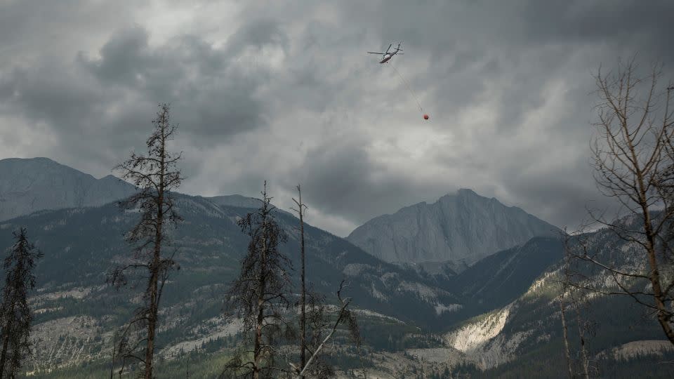
A helicopter buckets water onto smoldering fires outside of Jasper, Alberta, Canada, on Friday. Wildfires encroaching into the townsite of Jasper forced an evacuation of the national park. – Amber Bracken/The Canadian Press/AP
Lodge owner in Canadian tourist town sees business go up in flames
In Jasper, a popular tourist town in Alberta, 25,000 residents and visitors were forced to evacuate from a fast-moving blaze that has destroyed 30% of the town’s structures, officials said.
Two wildfires converged in the Jasper National Park area, becoming what authorities are referring to as the Jasper Wildfire Complex. It remains difficult to measure exactly how big the complex – which also includes a third nearby fire – is due to extreme fire behavior and thick smoke cover. Together, the fires have swallowed an estimated 89,000 acres, the Jasper National Park said.
An evacuation order remains in effect for Jasper and Jasper National Park, with the vast majority of evacuees being visitors, officials said. Along with about 4,100 residents – and thousands of seasonal workers – who live in the town, 2.48 million people visited Jasper National Park last year.
Out of a total of 1,113 structures in the town, 358 have been destroyed, according to a Facebook post from Jasper National Park.
The owner of Maligne Lodge in Jasper told CNN news partner CTV News that she was shocked when she saw a photo of the 98-room hotel up in flames. It had been in the family since 1961 after her father purchased the property, and she had been working there since she was a child.
“As soon as we’re given the go-ahead, we’ll be in there rebuilding our hotel,” Karyn Decore said.
Jasper Mayor Richard Ireland lost the home that his family had moved into around his second birthday, according to CTV News.
On a tour of the wreckage in Jasper, Ireland said that the loss of his home of 67 years “is shattering.”
“Now it’s memories of family and fire,” Ireland told CNN news partner CBC. “So many others are going to go through this same thing.”
But he said “when I stood back and looked, and saw what remains, I know that the community is still there.”
Wildfires are exploding across the West, especially in California, where the Park Fire has now grown to be the biggest in the state this year.
The largest of several wildfires in the state is the Park Fire, burning in Butte and Tehama counties, just north of Chico, which grew to over 348,370 acres on Saturday with 0% containment. At least 134 structures have been destroyed by the blaze, which has grown to be the 7th largest fire recorded in California history in only a few days.
California Gov. Gavin Newsom declared a State of Emergency for Butte and Tehama counties due to the Park Fire, as well as Plumas County, due to the Gold Complex Fire, which combined have burned more than 424,000 acres.
“We are using every available tool to protect lives and property as our fire and emergency response teams work around the clock to combat these challenging fires. Stay safe and remain alert for instructions from local authorities as dangerous fire weather conditions continue,” Newsom said in his statement.
Ronnie Dean Stout II, 42, has been arrested on suspicion of arson for starting the Park Fire after he allegedly pushed a burning car into a gully in Bidwell Park, near Chico, according to Butte County District Attorney Mike Ramsey.
There are more than over 2,400 personnel, six helicopters and 153 fire engines assigned just to the Park Fire.
The Lake Fire, in Santa Barbara County, is the second-largest burning in the state at the moment at over 38,000 acres, though it is 90% contained after sparking July 5.
Meanwhile, farther north, the Durkee Fire in Oregon had grown to over 288,000 acres on Friday morning with 20% containment, according to the Oregon/Washington Bureau of Land Management. It was sparked on July 17 by a lightning strike and has grown to the largest fire in the country this year.
More than 500 people fighting the fire, as rain fell overnight in the area, providing some relief for firefighters.
The pilot of a single-engine fire tanker carrying retardant was found dead on Friday in Grant County in eastern Oregon after the aircraft was reported missing, according to the Bureau of Land Management.
Smoke spreads across several western states
PHOTO: Wildfires burning in the West are creating unhealthy smoke conditions across several states. (ABC News)
The smoke from fires in Northern California and Oregon is spreading across several states, including Idaho, Montana and North Dakota, which will all see regions under “very heavy” smoke conditions — the second-worst level.
California’s Park Fire now among largest in state history as evacuation orders spread
Scott Sistek – July 27, 2024
https://s.yimg.com/rx/ev/builds/1.7.4/pframe.htmlScroll back up to restore default view.
CHICO, Calif. — The Park Fire burning in Northern California near Chico has now become one of the largest wildfires in state history as flames continue to grow, causing additional evacuations to now spread across four counties and taking aim at a community that is still reeling from a deadly wildfire just six years ago.
But some good news emerged for firefighters with the weather forecast as the weekend began without the triple-digit heat and Fire Weather Warnings of the past few days.
CAL Fire now estimates the Park Fire has burned nearly 350,000 acres as of midday Saturday, which ranks the fire as No. 7 on California’s list of most acreage burned by a fire. At least 134 homes and structures have been damaged or destroyed and another 4,200 are threatened, fire officials said. Over 50 community zones are now under evacuation warnings across 4 counties, spanning more than 4,400 people.
“Extreme fire behavior has occurred due to the slope and winds aligning, causing significant growth,” CAL Fire officials wrote in their Saturday morning update. “Damage inspection teams are working to identify structures that have been damaged or destroyed.”
So far, there are no reports of any deaths, but two people have been treated for minor injuries.
Vanessa Starling, who lives near the heavily damaged town of Cohasset, told FOX 2 Bay Area they could hear the sound as they evacuated their home.
“It was pretty crazy, there is one spot that had a little fire tornado going on. We could hear it, just this roaring sound, you can hear the fire roaring as we were leaving,” Starling said, worried about her family home. “We have property that’s been in our family since 1905.”
Late Friday night, the entire town of Paradise, California was placed under an evacuation warning, which means all residents should get ready to run if the fire gets closer.
“Fire behavior and predicted winds require all residents in Paradise to prepare to evacuate and await further information,” CAL Fire officials said.
It’s a particularly daunting reminder of wildfire dangers for this community that was devastated by the fast-moving Camp Fire in 2018 that left dozens dead as flames raced through town.
Additional evacuation shelters have opened in Red Bluff, Los Molinos, and the Butte County Fairgrounds in Gridley in addition to shelters in Chico.
Nearly 2,500 firefighters are dedicated to fighting the blaze as of Friday night, and California Gov. Gavin Newsome declared an emergency, allowing additional state resources to flow toward the fire.
The Park Fire began Wednesday as a bizarre care of arson, investigators said.
Witnesses spotted a man next to a car where a fire had started under the left wheel of what turned out to be the suspect’s mother’s vehicle, and watched it burn, according to Butte County District Attorney Mike Ramsey.
The man climbed into the vehicle for a few moments, then got out and pushed the flaming car down a 60-foot embankment into a gully, investigators said. The burning car eventually became engulfed, spreading flames into the nearby brush and eventually tearing through nearby neighborhoods.
The suspect was identified later that evening and arrested early Thursday morning. He’s being held in the Butte County Jail without bail, awaiting arraignment on Monday.
After days of fighting triple-digit heat and blustery winds that have triggered Fire Weather Warnings across much of Northern California, the weather pattern has finally shifted to give firefighters a temporary reprieve.
Cooler, ocean breezes have pushed inland, not only knocking temperatures down into the upper 80s and low 90s but increasing the humidity.
No weather alerts were in effect for Saturday and the pattern was expected to hold through the middle of the week. However, hotter weather and perhaps a return to triple digit heat was looming for later in the week.
Oregon wildfire explodes to half the size of Rhode Island
Rich McKay – July 26, 2024
Wildfire in Forest Ranch, CaliforniaWildfire northeast of Chico, CaliforniaWildfire in Forest Ranch, California
(Reuters) -Winds and lightning strikes have sparked and fanned wildfires across the Pacific Northwest this week, including the largest fire currently burning in the U.S., which was rapidly expanding near the Oregon-Idaho border on Friday.
The Durkee Fire near Huntington, Oregon, has scorched 600 square miles (1,600 square km), an area more than half the size of Rhode Island’s land mass, authorities said. It is threatening several towns.
The blaze was set off by lightning on July 17, and wind gusts up to 60 mph (100 kph) drove the flames across brush, timberland and ranches, killing hundreds of cattle. The fire was only 20% contained on Friday, officials said.
While there is zero chance of rain through next week, winds have dropped and cooler air is in store, said meteorologist Marc Chenard of the National Weather Service.
“Hopefully it gives firefighters a break,” he said.
As of Thursday, wildfires this year have burned almost 1 million acres (400,000 hectares) in Oregon and 125,900 acres in Washington, according to the Northwest Interagency Coordination Center in Portland, Oregon.
In 2020, the worst year in recent memory, Oregon wildfires scorched more than 1.14 million acres, according to a tally by CBS TV affiliate KOIN.
In California, the Park Fire, believed to have been started by an arsonist, has forced the evacuation of more than 4,000 residents in Butte County, about 100 miles northeast of Sacramento.
A suspect was arrested on Thursday, accused of pushing a burning car down a bone-dry gully.
The fire grew uncontrolled overnight from 125,000 acres on Thursday to 178,090 acres on Friday afternoon, according to the California Department of Forestry and Fire Protection. More than a hundred buildings had been damaged or destroyed.
“The biggest challenge with this fire is getting to it,” said Fire Captain Dan Collins. “It’s steep land with almost no roads. It’s hard to get our people and equipment to the fire lines.”
More than 1,600 firefighters were deployed to contain the blaze, CalFire said.
Forecasters warned that winds would reach 30 miles mph (50 kph) on Friday and through the weekend. Combined with low humidity, it is a recipe for rapid growth, officials said.
Smoke from fires in western Canada and the Pacific Northwest have brought hazy skies and unhealthy air from the Rocky Mountains to Minneapolis and as far east as Detroit, weather reports said.
Denver had the worst air quality in the U.S. on Friday and ranked the 30th worst in the world, according to IQAir, a group that tracks air pollution across the globe.
Much of the smoke coming into the Central and Eastern U.S. comes from a raging wildfire in the mountainous Jasper National Park in the Canadian province of Alberta.
The park and the town of Jasper, which draws more than 2 million tourists a year, were evacuated on Monday, displacing 10,000 residents and 15,000 park visitors. As much as half of the structures in the town could be damaged or destroyed, officials said, as the blaze burned more than 89,000 acres as of late Thursday.
Videos posted on social media show entire streets leveled by the blazes in the Alberta province, with scorched trees, charred metal skeletons of cars, and nothing but rubble where homes and businesses had stood.
(Reporting by Rich McKay in Atlanta; Additional reporting by Jonathan Allen; Editing by Rod Nickel, Sandra Maler and William Mallard)
Two fires moving at speeds of more than 60 miles-an-hour converged in the Canadian Rockies on Wednesday, burning through the town of Jasper — along the Athabasca River in Alberta, Canada — destroying nearly a third of its structures.
More than 25,000 residents and visitors were evacuated this week from the tourist town and surrounding Jasper National Park, officials said.
Rain and cooler temperatures helped to subdue the fire somewhat on Thursday, officials said, but the fire is still burning. Firefighters continued to fight fires in the town, moving from one building to another on Thursday, according to an update from Parks Canada.
A male elk crosses the Yellowhead Highway, a route roughly followed by Kinder Morgan’s Trans Mountain Pipeline through the Rocky Mountains, in Jasper National Park, Alberta, Canada November 14, 2016.
“There’s no denying this is the worst nightmare for any community,” said Alberta Premier Danielle Smith.
“For many generations, the town of Jasper and the park surrounding it have been a source of pride with some of the most beautiful scenery in the entire, in the world,” said Smith, as she was overcome by emotion.
A general view shows the Howse Pass Viewpoint between the Banff and Jasper national parks, in Alberta, on September 9, 2022.
How much of Jasper was damaged in the fires?
Of 1,113 structures in the town of Jasper, 358 of them were destroyed in this week’s fire, according to a Friday update from the incident command team overseeing the firefighting effort, which includes Parks Canada.
The fire is estimated at roughly 88,000 acres in size, although areas within that perimeter may be only partially burned or not burned at all.
Firefighters said they were able to protect the town’s critical facilities, including the hospital, emergency services buildings, both the elementary and junior/senior schools, an activity center and the wastewater treatment plant.
The fire damaged a number of bridges throughout the national park, including the Moberly Bridge and the Old Fort Point Bridge, the park said. Bridges on the region’s famed Icefields Parkway will be assessed for structural damage, and parks officials said that would slow down access to the picturesque Maligne Lake southeast of town.
The most significant structural damage occurred on the town’s southwest side, officials said Thursday.
Crews continue to fight the fire “and we remain focused on making it safe for the people of Jasper to come home,” the Friday morning update stated. The area remains closed for public safety and the evacuation order remains in effect.
Jasper’s residents and visitors scoured social media posts for news this week trying to get word about their community.
Bishop Stephen London with the Anglican Diocese of Edmonton confirmed in a Facebook post that the St. Mary and St. George Anglican Church in Jasper was destroyed by the flames.
Jasper Mayor Richard Ireland called the fire an “unprecedented challenge.”
The blaze ravaged Jasper, Ireland said in an update. “The destruction and loss that many of you are facing and feeling is beyond description and comprehension.”
What is Jasper, Canada known for?
“Known for its vast wilderness, majestic peaks, abundant wildlife and outstanding natural beauty, visitors from all over Canada and round the world travel here to experience this very special place,” Parks Canada’s website says.
Jasper is a tourist destination for those who visit the Rockies and Jasper National Park. The park is a World Heritage Site with more than 2 million visitors a year passing through the gates, according to the town’s website. Tourists travel the Icefields Parkway between Jasper and Banff National Parks and visit Athabasca Falls and Athabasca Glacier.
Idyllic scene in Maligne Lake in Alberta’s Jasper National Park in 2016.
One of Canada’s national treasures, the park boasts over 2.7 million acres and is the largest in the Canadian Rockies. It was established as Jasper Forest Park reserve in 1907 and became a national park in 1930. About 70 species of mammals live there, according to National Geographic, including grizzly bears, moose and elk. The park serves as a preserve for species of wildlife that have declined in other areas.
What’s the Athabasca Glacier?
The Columbia Icefield is the largest remnant of a thick ice mass that once covered much of the area in the Canadian Rockies. The Athabasca Glacier flows from the icefield and down into the valley, where tourists can walk up to the toe of the glacier, following a series of markers that show how much the warming climate has melted the glacier.
Athabasca Falls in Jasper National Park in 2016. Parts of the park were burned over in a fire on July 24-25, 2024.
The Athabasca has been averaging a retreat of about 16 feet a year. In 2023, when global average temperatures were their hottest on record, the Athabasca Glacier saw more glacial melt than in any of the previous 10 years, according to Parks Canada.
Durkee Fire creates extreme storms, wind and closes I-84 in eastern Oregon
Emma Logan, Salem Statesman Journal – July25, 2024
The Durkee Fire in eastern Oregon reached 244,858 acres as of Wednesday morning. The area is expecting hurricane force winds along with thunder and lightning storms Wednesday night.
This story was updated at 9:30 a.m. Thursday
One of the biggest fires burning in the United States is the Durkee Fire in eastern Oregon. As of Thursday morning, the fire was reported to be at least 270,000 acres and is 0% contained. The National Weather Service said storms brought close to 3,000 lightning strikes in the area.
The Oregon Department of Transportation closed Interstate 84 from Pendleton to Ontario on Wednesday due to unpredictable fire activity in the area. ODOT does not have an expected opening and travelers should not plan to use I-84 for travel. Check TripCheck for updates.
Heading into Wednesday afternoon, the area is under a red flag warning, hurricane force winds and a flash flood warning, according to the Durkee Fire updates. The National Weather Service also expects extreme thunderstorms and lightning in the area.
Due to the immense heat the Durkee Fire is creating and the existing winds, it is creating its own storms and changing the overall wind patterns.
“We call those pyrocumulus and you end up with a thunderstorm over the fire because there’s so much heat and just enough moisture above the fire to get a storm that forms,” Mike Cantin, a meteorologist from the National Weather Service in Boise, Idaho, said.
This happens due to the air surrounding the fire being drawn toward the fire creating erratic winds in the area. The gusty winds created could spread to other areas and elevate the danger for firefighters.
The Durkee Fire in Baker County has impacted travel on Interstate 84 Tuesday and Wednesday. The Oregon Department of Transportation recommends using US 20 as an alternate route.
“The low elevation fuels, all the grass, the sagebrush, all of the trees below 6,000 feet are ready to burn. Any ignition source no matter how small can start another major wildfire,” Cantin said.
On Saturday, Gov. Tina Kotek invoked the Emergency Conflagration Act for the fire.
“The wildfires in Eastern Oregon have scaled up quickly,” Kotek said in a new release on Wednesday. “We are facing strong erratic winds over the region that could impact all fires. Rain is not getting through. Some communities do not have power. The situation is dynamic, and the teams on the ground are taking it day by day. I have deployed resources from the National Guard that are currently serving eastern and southwestern Oregon. I know these communities are supporting one another, doing their part to heed the guidance from officials and showing tremendous gratitude for our firefighters.”
On Friday, the Oregon State Fire Marshal sent structural protection resources in the form of firefighters and equipment to fight the fire in Eastern Oregon.
The fire was first reported last Wednesday and sparked by lightning strikes. The fire has brought level 1, 2 and 3 evacuations around Baker County. An evacuation map can be found at bit.ly/3YaNUJ0
“If you are outside, don’t create any sparks. Don’t drag a chain, if you are driving an RV make sure your chains are tied up, don’t park your car over grass, the heat of the engine could ignite it,” Cantin said. “This is one of those critical situations, that’s why fire are getting so big the weather is just right and the grass and sage and trees are ready to burn, all it takes is just a little bit.”
Here’s the latest on wildfires burning across Oregon.
Slate Fire burning 5 miles south of Detroit Dam
The Slate Fire in Willamette National Forest grew to at least 45 acres on Wednesday and was burning 5 miles south of Detroit Dam.
A multi-agency response performed suppression activities over Tuesday night. An air attack took place Wednesday as suppression attempts continue.
Forest Service Road 2212 will be closed from the dam to FS Road 1133 intersection to assist emergency crews’ access.
There are no current evacuation orders as of Wednesday afternoon.
Boneyard Fire reaches 49,716 acres at 3% containment
Boneyard Fire evacuation map.
A level 3 “Go Now” evacuation order has been issued in Monument and from the south Morrow County line, north to Forest Service Road 21 and to the east Morrow County line for the Boneyard Fire in northeastern Oregon.
The fire was reported to be 49,716 acres and 3% contained as of Wednesday.
There is potential for the Boneyard Fire to merge with the 56,139-acre Monkey Creek Fire to the east.
An evacuation center has been set up at Grant Union High School (911 S Canyon Blvd., John Day).
A community meeting for the fire is panned 6 p.m. Thursday at the Long Creek High School gym (375 E Main St., Long Creek).
Parts of Oregon see 75 days without rain as fires rage
As more than a dozen fires burned on national forestland in the Pacific Northwest, some areas have gone more than 75 days without rain as of Tuesday morning, according to the U.S. Forest Service.
The record dryness was partly due to the lack of moisture in the Pacific Northwest. The Fremont-Winema and Deschutes national forests had gone more than 75 days without rain.
The Rogue River-Siskiyou National Forest in southern Oregon and Wallowa-Whitman in the east had both gone at least 45 days without rain, as has the Okanogan-Wenatchee.
Crews work on the Falls Fire burning in Grant and Malheur counties. There were at least 14 fires burning on national forest lands in the Pacific Northwest Region on Tuesday.
The lightning storms last week produced more than 2,000 strikes in 48 hours, causing rapid wildfire growth in already dry timber regions.
“This is shaping up to be another monster fire year in the Pacific Northwest, and it’s just mid-July,” said Ed Hiatt, Pacific Northwest assistant fire director for operations.
Every year, 75% of wildfires are human-caused, according to the Forest Service. In an effort to reduce this, all 17 national forests in the region were in campfire restrictions.
Temperatures were expected to cool by the end of the week, but the lack of moisture was expected to continue to keep forests and grasslands at critical fire conditions, the Forest Service said.
Campfires temporarily banned at Oregon State Parks
Campfires are banned at most state parks due to dry conditions and the strain on firefighting resources, the Oregon Parks and recreation Department announced Tuesday. All parks east of the Cascades will be under campfire bans. Fires and open flames will also be banned at parks in high-risk areas until conditions improve.
A list of parks under the campfire ban are listed at bit.ly/4fdeLud
Several parks have been closed due to wildfires including Battle Mountain Forest Scenic Corridor, Farewell Bend State Recreation Area, East and West Hatfield Trailheads on the Columbia River Highway State Trail and Ukiah-Dale Forest State Scenic Corridor.
OPRD encourages visitors to check park webpages before visiting. Find updated information at stateparks.oregon.gov/
Ray Benson Sno Park temporarily closed to station firefighters
The Willamette National Forest has temporarily closed the Ray Benson Sno Park. The area will be used as an incident command post for nearby wildfires.
The Ray Benson site is located within the Santiam Pass Recreation Area. The access road FS Road 2690-902 will also be closed. The remainder of the Santiam Pass Recreation Area remains open.
Rocky Mountain Complex includes seven lighting started fires
Oakridge Lightning Fires map.
The lightning storm on July 17 ignited seven wildfires to the north, south and southeast of Oakridge and Westfir. The Rocky Mountain Complex Incident Team 1 assumed command of the fires on Tuesday.
Fire suppression efforts are underway beginning with fires deemed highest priority — Chalk, Coffeepot and Moss Mountain fires.
The Chalk Fire is the largest of the complex at 2,247 acres and 0% containment. Infrared flights on Tuesday revealed the fire grew by 1,000 acres. The Chalk Fire shares a perimeter with the 2021 Gales Fire scar, which should slow progress and help crews contain the flames.
Lane 1 wildfire prompts level 1 evacuation warnings
The Lane 1 Fire burning southeast of Cottage Grove has prompted Level 1 ‘Be Ready’ evacuation orders for areas east of Cottage Grove, according to the Lane County Sheriff’s Office. As of Tuesday evening, the fire has burned 1,090 acres.
Areas east of Disston starting at Brice Creek Road milepost 0.7 and following Brice Creek Road south are under the Level 1 notice.
The Lane County Sheriff’s Office has closed Brice Creek Road east of the Umpqua National Forest Boundary and all of Sharps Creek Road. People camping in the Brice Creek, Sharps Creek, Champion Creek, Bohemia and Fairview Peak areas are advised to leave now.
Air quality advisory issued for southern, central and eastern Oregon
The Department of Environmental Quality’s air quality advisory due to fire smoke issued on Monday is still in effect until further notice. The air quality advisory is for the following counties: Grant, Wheeler, Crook, Deschutes, southern Umatilla and southern Morrow, Klamath, eastern Douglas, and northern Harney and northern Malheur counties
The DEQ expects intermittent smoke in Union, Baker, Wallowa, Jackson, Josephine, Gilliam, eastern Lane and northern Lake counties due to smoke from fires in Oregon.
Areas east of the southern Oregon fires like Crescent and Diamond can expect periods of unhealthy air quality conditions, according to the DEQ. Roseburg and Cottage Grove should remain good with little impact from smoke.
Smoke levels can change rapidly. Up to date information can be found on the DEQ’s Air Quality Index.
Light winds expected to lessen fire activity of Pyramid Fire over next three days
The lightning-caused Pyramid Fire burning east of Sweet Home in the Tombstone Pass area north of Highway 20 and south of Detroit near Santiam Junction remains at 535 acres and 0% contained as of Wednesday morning.
Significant progress has been made toward the opening of roads and establishment of a control line around the fire’s perimeter, the news release said. Additional crews and firefighting equipment will be added to strengthen suppression efforts.
Due to the fire burning in an old-growth forest, fire behavior specialist Jeff Shelton does not anticipate significant fire activity to occur in the next three days. The light wind is causing the smoke to behave like a lid holding the fire’s activity.
There was increased fire activity in the southwest flank, but very little activity was observed in the remainder of the area, according to the update. The control focus on Tuesday was to protect the Middle Santiam Wilderness, private industrial timberlands and nearby communities.
The Linn County Sheriff’s Office announced Monday night “There is still no imminent danger to structures, the town of Sweet Home, or of closures to Highway 20” despite the fire behavior and dangerous conditions.
Linn County Sheriff Michelle Duncan issued a level 3 “go now” evacuation order for a large area of the Sweet Home Ranger District that mostly includes hiking trails and campgrounds in the Old Cascades region. The evacuation was coordinated with the U.S. Forest Service, and a closure of the area was likely. View a map of the closure area at tinyurl.com/LinnCoFireMap.
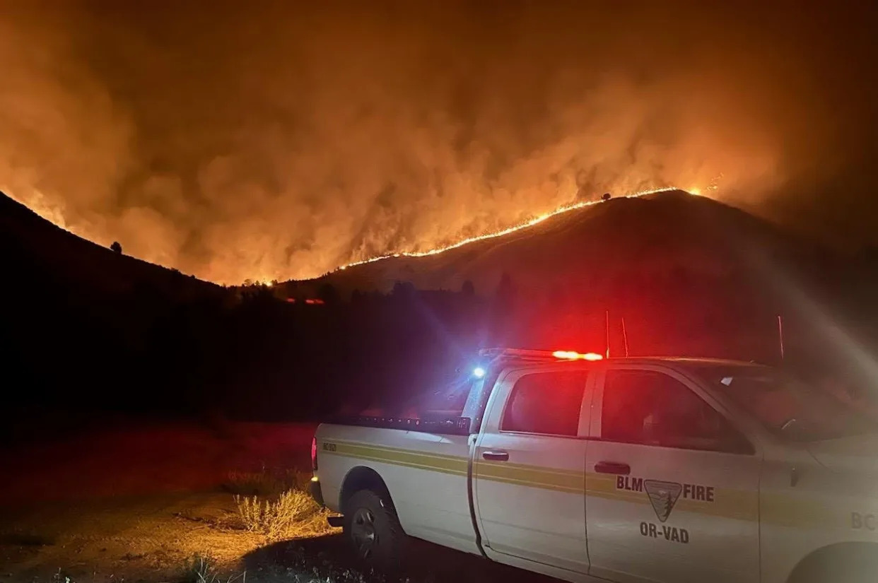
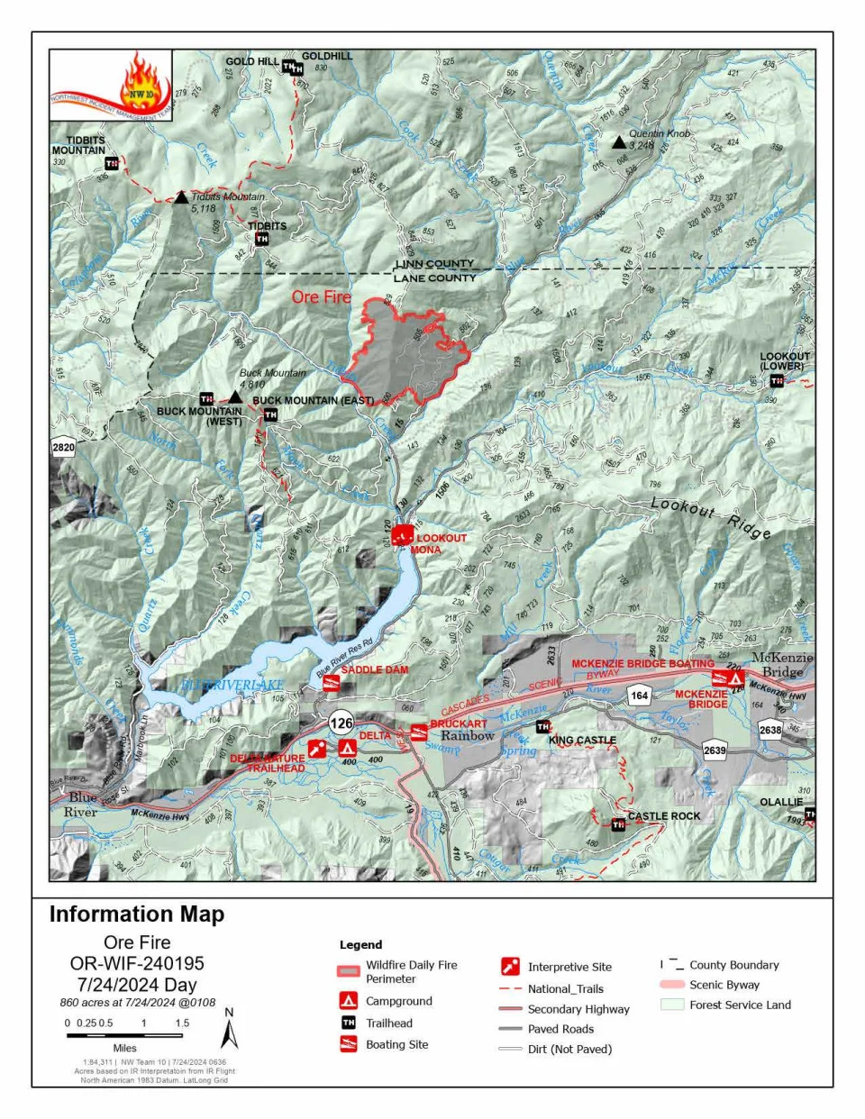
Ore Fire continues to grow amid rugged conditions and extreme fire behavior
Ore Fire information map.
The Ore Fire burning 7 miles northeast of Blue River was burning 860 acres as of Wednesday morning.
Fire managers are focusing on activities with the highest probability of success and least amount of risk to firefighters, communities and resources. The rugged and steep terrain, falling rocks, rolling debris, fire-weakened trees and extreme weather conditions continue to pose safety challenges for crews.
Burning debris rolling down steep slopes caused the fire to cross the established control line at FS 1509 Road on Tuesday. Firefighters were able to control the flames but falling debris will remain a challenge.
Buck Mountain Trail, Tidbits South and West Trail, Gold Hill Trail, Mona Campground, Lookout Campground and Saddle Dam Boat Launch are closed.
Other closures in the Willamette National Forest due to fire-impacted areas can be found at bit.ly/4dcWMCl
Homestead Complex reaches 910 acres
The Homestead Complex Fire, a group of fires in the Umpqua National Forest, had a combined 910 acreage total Wednesday morning.
The incident management teams assigned to the Homestead Complex and Diamond Complex will hold a joint community meeting at 5:30 p.m. on Wednesday in the Old Glide Middle School Gym.
On Tuesday, crews worked in both directions on the 258-acre the Horse Heaven Creek Fire, the most active in the complex, until fire activity intensified causing a switch to indirect tactics. Attempts at aviation intervention were thwarted due to thick smoke. Crews will try and build a containment line today, the news release said.
The steep and rugged terrain of the 267-acre No Man Fire makes it difficult to get firefighters on the ground near the fire’s edge. Crews will work to establish indirect control lines.
As of Wednesday, containment lines are being established for the 84-acre Reynolds Butte Fire and the 35-acre Lost Bucket Fire.
The 38-acre Fuller Lake Fire and 110-acre Bullpup Fire will remain unstaffed until resources become available.
The Umpqua National Forest issued closures for all of the Cottage Grove Ranger District and parts pf the Diamond Lake, North Umpqua and Tiller ranger districts. Boulder Flat Campground and Boat Launch are closed under the order.
BLM closes public lands due to wildfires southeast of Cottage Grove
Bureau of Land Management public lands southeast of Cottage Grove are closed due to wildfires in the areas of Sharps Creek and Clark Creek.
“The closure is for public and firefighter safety, and to allow fire suppression crews to continue to safely respond to the incident,” according to a Saturday news release from the BLM Northwest Oregon District.The closure area includes:
The Sharps Creek Campground and BLM-managed public lands southeast of the town of Dorena, surrounding Sharps Creek Road (County Road 2460 / BLM Road No. 23-1-12) and Clark Creek Road (BLM Road No. 23-1-13). It includes BLM lands in Township 22S, Range 1W, and Township 23S, Range 1W, Sections 1-3, 11-14, 22-24, 26-27, 33-34.
These areas are closed to the public and for activities including hiking, mining, hunting and camping.
BLM said Sharps Creek Road and Clark Creek Road are open to residents in the closure area.
Favorable weather helps crews fighting Microwave Tower Fire near Mosier
Crews were able to make progress by establishing lines on the east end of the 704-acre fire, as of Wednesday morning.
The fire has continued to creep down a north-facing ridge along I-84 and west of Mosier.
Authorities estimated 100 homes under level 3 and 500 residents were threatened in the Mosier area. Residents in Mosier west of the Columbia Gorge were being asked to evacuate due to the Microwave Tower Fire, which is being driven by strong winds.
Here are the evacuation levels for areas in Mosier related to the fire:
Level 3 “go now”: From Highway 30 south of Proctor Road, east to Huskey Road and the border of Mosier and west to the Hood River County line.
Level 2 “get set”: Mosier and from Huskey Road east to Mosier Creek Road and south to Jasper Lane.
Level 1 “be ready”: From Mosier Creek Road, east to Dry Creek Road, north to Mosier border and south to Osborn Cutoff Road.
There is a Red Cross shelter available for evacuees at Hood River Middle School, 1602 May St.,, Hood River, OR., 97031.
The fire started Monday afternoon west of Rattler Ridge west of Mosier.
The fire is burning in grass and timber and was being pushed eastwards by strong westerly winds.
“The fire has seen moderate activity with intermittent single tree torching, some flanking and smoldering creating a moderate amount of smoke,” according to a Wednesday update from the Oregon Department of Forestry. “The fire also saw growth backing down the north slope. With the expected increased winds today, crews are ready to address increased fire behavior. There is a potential for increased smoke in the area.”
20 fires burn at least 3,811 acres in the Diamond Complex
In the past 24 hours, 8 new fires at a combined 62 acres have been identified and added to the Diamond Complex on the Diamond Lake Ranger District of the Umpqua National Forest. The complex is 3% contained.
All fires are under a full suppression strategy with firefighters directly attacking the fire line where feasible.
These are the active fires in the complex:
Pine Bench: 1,472 acres (north of Highway 138 near Dry Creek)
Trail: 827 acres (east of Highway 138 on the west slope of Mount Thielsen)
Lemolo: 518 acres (north of Lemolo Lake on Bunker Hill)
Pig Iron: 27 acres (Pig Iron Mountain north of Highway 138)
Watson: 144 acres (north of Highway 138 on Watson Ridge)
Brodie: 95 acres (about 5 miles south of Highway 138 and south of Devils Canyon)
Trep: 101 acres (about 4 miles south of Highway 138)
Garwood: 5 acres (about 3 miles southwest of Mount Bailey)
Slide: 0.1 acres (northeast of Pine Bench)
Potter: 327 acres (north of Highway 138 about 2 miles southeast of Potter Mt.)
Ooya: 123 acres (north of Highway 138 about 1 mile northeast of Bird Point)
Clearwater: 7 acres (south of Highway 138 about 5 miles northwest of Diamond Lake)
Elephant: .07 acres (2 miles southwest of Lemolo Lake)
Lost Bear: 5 acres (2 miles south of Hwy 138)
Lost: 12 acres (4 miles south of Hwy 138)
The eight newest fires have not been named and are widely scattered in the area.
A level 2 “be set” evacuation warning was issued due to the Boulder Flat/Pine Bench Fire east of Roseburg and Glide in the North Umpqua Canyon near Toketee Falls. The evacuation was for homes in the Slide Creek area downstream to the Soda Springs area due to a fire near Soda Springs and Pine Bench in Toketee. A map of the evacuation area can be found here: bit.ly/4dc3qsB.
The weather on Tuesday was forecast to be lower in relative humidity and slightly higher in temperature. The conditions will support increased fire spread and spotting potential. This will add to the challenging fire behavior due to rugged and steep terrain.
Lemolo Fire reaches 404 acres in Douglas County
The Lemolo Fire in Douglas County had reach 423 acres as of Wednesday morning and was 0% contained.
The Douglas County Sheriff’s Office on Saturday night issued level 3 “go now” and level 2 “be ready” evacuation orders for the Lemolo Fire. The fire was reported to be at least 373 acres as of Sunday night.
Level 3 evacuations were issued for:
Bunker Hill Campground
Kelsay Valley Campground
The North Umpqua Trail between USFS 2612 Road and Windigo Pass intersection, west to North Umpqua Trail as it intersects with USFS 2612 Road.
This includes all areas on north and northeast side of Lemolo Lake, according to the sheriff’s office.
Level 2 evacuation orders have been issued for:
East Lemolo Campground
USFS 2614 Road south of Inlet Campground, including Kelsay Valley, Pumice Flat and Elbow Butte areas.
Falls Fire reaches 140,422 acres and 50% containment in Grant and Harney counties
The Falls Fire burning in Grant and Harney counties near Burns was 140,422 acres and was 50% contained as of Wednesday morning.
A cold front bringing wind and thunderstorms is anticipated to hit the Falls Fire area on Wednesday evening.
The fire was reported to be active on Monday afternoon due to southwest winds, which prompted growth along parts of the northern perimeter of the fire, according to the Tuesday morning update.
On Tuesday, Oregon State Fire Marshal crews were set to remain active on the northeast, east and southern parts of the fire.
The Oregon State Fire Marshal requested help from California to protect life and property against the fire on Friday.
The California Governor’s Office of Emergency Services provided three strike teams with 15 fire engines and 80 firefighters from nine different counties to provide structural protection.
Level 1, 2 and 3 evacuation orders remained in place in Grant and Harney counties. The Harney County Sheriff’s evacuation map can be found at bit.ly/4d1XvX2 for the most accurate evacuation notices.
Ten residences and 13 “other” structures were destroyed in the early stages of the fire, according to Oregon State Fire Marshal structure teams.
Round Mountain, Wickiup fires burn in Central Oregon
The Round Mountain and Wickiup fires on Deschutes National Forest remained at a combined 276 acres as of Tuesday morning. The Wickiup Fire is now 50% contained and Round Mountain is at 20%.
Crews were set to continue mop up for hot spots and secure the perimeter for both fires on Tuesday.
Campfires prohibited on BLM public lands in Northwest Oregon District
Campfires are now prohibited on all Bureau of Land Management public lands throughout the Northwest Oregon District.
Fires, campfires, smoking in vegetated areas, using vehicles in unmanaged vegetated areas, operating a chainsaw, welding, cutting or grinding, or using an internal combustion engine without a spark arrestor will be prohibited. The BLM announced Monday these stronger restrictions will remain in effect until rescinded.
More information on restrictions and closures can be found at blm.gov/orwafire
Fire restrictions in place for Willamette and Siuslaw national forests, majority of places in Oregon
The majority of Oregon’s national and state forests outlawed campfires, except in campgrounds.
Willamette National Forest and Siuslaw national forests, to the east and west of the Willamette Valley, implemented fire restrictions this week.
Fire restrictions prohibit all campfires, charcoal or briquette fires, pellet fires or other open fires outside of designated campgrounds. Building, maintaining or using a fire, campfire or stove was still permitted in designated metal campfire rings or grills in designated recreational sites.
Restrictions for smoking, off-highway vehicles and chainsaws in campgrounds were also in effect.


 Scroll back up to restore default view.