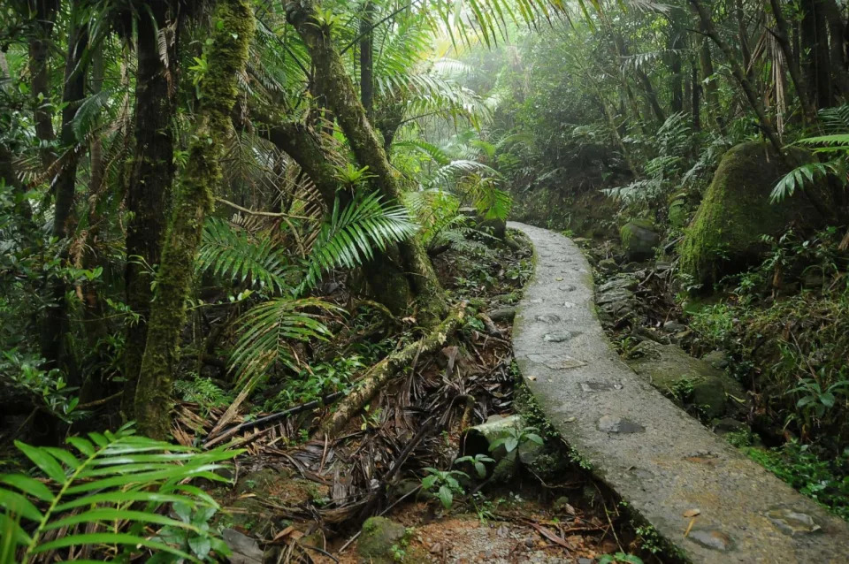
Viral video shows the shocking technique used to clear poison ivy from hiking trails: ‘[This is] really innovative’
Roberto Guerra – August 27, 2023
An Instagram Reel shows how goats are helping get rid of poison ivy along a popular forested trail.
The video was posted on the page Kut Austin (@kut_austin), which is “a community-supported public media newsroom sharing news and information on-air at 90.5 FM and online at KUT.org.”
“An army of goats is clearing poison ivy from the trails around Austin’s Lady Bird Lake,” the caption on the opening scene reads.https://www.instagram.com/p/CuupPjvpo95/embed/captioned?cr=1&v=12
The video shows an array of goats inside a forest, eating away at bushes and plants which are described in the captions as poison ivy and invasive plants.
This can apparently be an effective way of getting rid of poisonous and invasive plants, which can have adverse effects on ecosystems, like reducing biodiversity.
Herbicides are commonly used to deal with invasive and poisonous plant species, but these bring about their own problems and can be even worse for the environment than the invasive species.
There are also other natural, non-toxic ways to get rid of unwanted plants, either for your garden or for an entire forest. Among these methods are bringing in other plant species to combat the unwanted ones or simply pulling them out manually by the roots.
Bringing in animals to eat them is among the most efficient ways of taking care of the problem since they end up doing most of the work and benefit from it as well, resulting in a mutually beneficial relationship.
The Trail Conservancy, the nonprofit organization that maintains the forested trail, came up with the idea of bringing in animals to take care of the problem.
“It’s a really innovative and creative alternative to some of the other tactics we could use to eradicate poison ivy, like controlled burns, which affect air quality, or chemicals, which affect water quality in the lake,” The Trail Conservancy’s CEO Heidi Anderson said.
Viewers of the Reel also had plenty to say.
“Through careful rotational grazing with multiple animals, it’s amazing how well an area can be maintained,” one person wrote in the comments.
Join our free newsletter for cool news and cool tips that make it easy to help yourself while helping the planet.
Mystery land buyers around California Air Force base revealed
Tom Palmer – August 26, 2023
(NewsNation) – New reports shed light on nearly $1 billion in land purchases by a mysterious company near a California Air Force base that raised national security concerns.
Since 2018, a group called “Flannery Associates” invested more than $800 million on almost 54,000 acres of agriculture-zoned land surrounding the Travis Air Force base in Solano County, California, public records show.
Despite early speculation China was behind the purchases — amid concerns that companies with ties to China have been ramping up efforts to buy American farmland — legal representation for Flannery has maintained the group is controlled by U.S. citizens, with 97% of its capital coming from U.S.-based investors.
However, after eight months of investigation, federal officials were not able to confirm or deny this to be true, and were not able to determine exactly who was backing the company.
Now, reports from The New York Times and San Francisco Chronicle reveal Flannery is comprised of a group of ultra-wealthy Silicon Valley investors acquiring vast parcels of land northeast of San Francisco with the mission to build a new California city “from scratch.”
According to the reports, the investors’ plan for the land involves creating a new urban center that could accommodate the growing demands of the tech industry and provide a fresh environment for innovation and economic growth.
The goal, according to the reports, is to establish a new city that caters to the needs of Silicon Valley tech companies and professionals, potentially alleviating some of the challenges posed by congestion, housing shortages and high costs of living in the Bay Area.
The San Francisco Chronicle reports that these land acquisitions have been met with a mix of excitement and concern from local communities and government officials.
Democratic California Rep. John Garamendi called developments around Travis Air Force Base a critical national security issue.
“The fact they chose to buy all three sides of the Travis Air Force Base even raises immediate questions about national security,” Garamendi said.
To pull off the project, according to the Times, the company will have to use the state’s initiative system to get Solano County residents to vote on it.
Garamendi said utilizing an initiative means they’re going to override the local protections that are in place for Travis Air Force Base.
According to Garamendi, the area is “heavily impacted by some very severe restrictions that prevent development and other kinds of activities that would somehow degrade or harm Travis Air Force Base.”
The Air Force’s Foreign Investment Risk Review office is currently investigating Flannery Associates. Garamendi says there are valid concerns that Flannery’s land acquisitions could be tied to foreign enemies.
“Wherever the money is coming from,” he said, “the underlying problem of securing Travis Air Force Base remains.”
Garamendi also said the “organization has been just playing nasty,” referring to farmers in the area being targeted in a lawsuit from the group.
“Please understand that this group spent five years secretly and in my estimation, using strong-arm techniques that would best be associated with monsters to acquire the land,” he said.
Garamendi said he’s been in contact with the families of farmers who handed over their land to Flannery, saying they didn’t want to sell in the first place.
Since no California laws require them to sell, the land was bargained for by both parties at a much higher price. But now, Flannery is suing those families for $510 million, accusing them of conspiring together to inflate the value of the land.
“It’s a suit designed to force the farmers to lawyer up, spend tens of thousands of dollars on lawyering and maybe at the end of the day, bankrupt themselves,” Garamendi said. “In fact, that has happened to at least one family that I know of and I’ve heard rumors that another family simply said, ‘We can’t afford the lawyers.’”
NewsNation correspondent Emily Finn contributed to this article.
California high-speed rail project looks to build Central Valley train fleet
Vanessa Arredondo – August 26, 2023
The Road 27 grade separation in Madera County was built to take traffic over the existing BNSF rail and future high-speed rail lines. (California High-Speed Rail Authority)
California’s high-speed rail project is working to secure its fleet of trains as it looks to stay on track to open an initial segment in the Central Valley.
The High-Speed Rail Authority’s board of directors on Thursday approved a plan to screen prospective vendors to manufacture and maintain the electrified high-speed trains, which are planned to operate at speeds of about 220 mph.
“The project is continuing to make progress with our commitment unwavering as we remain active and aggressive in moving the project forward while actively pursuing federal funding,” authority spokesperson Micah Flores wrote in an email.
Gov. Gavin Newsom has adopted a scaled-down blueprint for the bullet train that proposes building a 171-mile starter segment in the Central Valley — connecting Bakersfield to Merced. Officials are looking to begin operating in 2030, but that timeline could stretch out to 2033, according to an agency progress report from earlier this year.
“This is an aggressive schedule, as we still have much to do including the extensions north and south to Merced and Bakersfield, track, systems and trainset procurement,” Flores said.
A 700 foot bullet train bridge across Road 27, between Road 27 and Club Drive, and the BNSF main line in Madera County. (Gary Coronado/Los Angeles Times)
Newsom adopted the plan for a starter system in the Central Valley in a bid to garner public support for construction of the more expensive passages in the Bay Area and Southern California.
Officials expect to receive bids from potential manufacturers in November and will review applications by the first quarter of 2024.
The High-Speed Rail Authority aims to obtain at least 10 trainsets that can operate at 220 mph and reach speeds up to 242 mph. The goal would be to produce two prototypes by 2028 for testing and trial runs.
“These trainsets ensure that we are procuring the latest generation of high-speed trains for this first-in-the-nation project,” agency Chief Executive Brian Kelly said in a release. “We look forward to working with members of the industry as we strive to develop a market for high-speed trains in the United States.”
There are 30 active high-speed rail construction sites in the Central Valley, according to the agency. Nearly 422 miles, from the Los Angeles Basin to the Bay Area, have been environmentally cleared for the project.
Construction began in 2015, about seven years after voters approved initial funding. The project has long been troubled, however, and it faces significant funding gaps. Earlier this year, an official estimate showed projected ridership has dropped by 25%.
The authority estimates that trains between Los Angeles and San Francisco would shuttle 31 million riders per year.
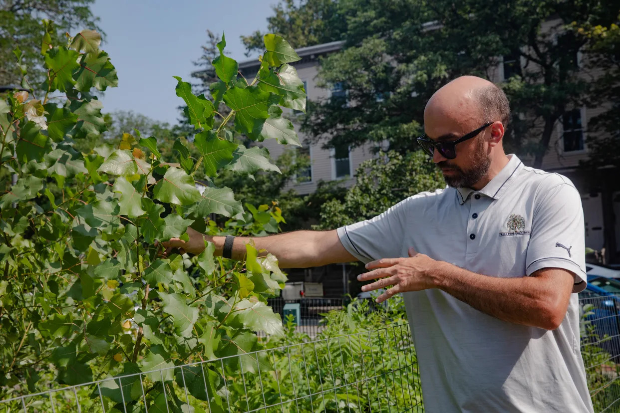
Andrew Putnam, superintendent of urban forestry and landscapes for the city of Cambridge, Mass., in Danehy Park, near Harvard University, July 26, 2023. (Cassandra Klos/The New York Times)
The tiny forest lives atop an old landfill in the city of Cambridge, Massachusetts. Although it is still a baby, it’s already acting quite a bit older than its actual age, which is just shy of 2.
Its aspens are growing at twice the speed normally expected, with fragrant sumac and tulip trees racing to catch up. It has absorbed stormwater without washing out, suppressed many weeds and stayed lush throughout last year’s drought. The little forest managed all this because of its enriched soil and density, and despite its diminutive size: 1,400 native shrubs and saplings, thriving in an area roughly the size of a basketball court.
It is part of a sweeping movement that is transforming dusty highway shoulders, parking lots, schoolyards and junkyards worldwide. Tiny forests have been planted across Europe, in Africa, throughout Asia and in South America, Russia and the Middle East. India has hundreds, and Japan, where it all began, has thousands.
Now tiny forests are slowly but steadily appearing in the United States. In recent years, they’ve been planted alongside a corrections facility on the Yakama reservation in Washington state, in Los Angeles’ Griffith Park and in Cambridge, where the forest is one of the first of its kind in the Northeast.
“It’s just phenomenal,” Andrew Putnam, superintendent of urban forestry and landscapes for the city of Cambridge, said on a recent visit to the forest, which was planted in fall 2021 in Danehy Park, a green space built atop the former city landfill. As dragonflies and white butterflies floated about, Putnam noted that within a few years, many of the now 14-foot saplings would be as tall as telephone poles and the forest would be self-sufficient.
Healthy woodlands absorb carbon dioxide, clean the air and provide for wildlife. But these tiny forests promise even more.
They can grow as quickly as 10 times the speed of conventional tree plantations, enabling them to support more birds, animals and insects and to sequester more carbon, while requiring no weeding or watering after the first three years, their creators said.
Perhaps more important for urban areas, tiny forests can help lower temperatures in places where pavement, buildings and concrete surfaces absorb and retain heat from the sun.
“This isn’t just a simple tree-planting method,” said Katherine Pakradouni, a native plant horticulturist who oversaw the forest planting in Griffith Park. “This is about a whole system of ecology that supports all manner of life, both above and below ground.”
The Griffith Park forest occupies 1,000 square feet and has drawn all manner of insects, lizards, birds and ground squirrels, along with western toads that journeyed from the Los Angeles River, Pakradouni said. To get to the forest, the toads had to clamber up a concrete embankment, traverse a bike trail, venture down another dirt embankment and cross a horse trail.
“It has all the food they need to survive and reproduce, and the shelter they need as a refuge,” Pakradouni said. “We need habitat refuges, and even a tiny one can, in a year, be life or death for an entire species.”
Known variously as tiny forests, miniforests, pocket forests and, in the United Kingdom, “wee” forests, they trace their lineage to Japanese botanist and plant ecologist Akira Miyawaki, who in 2006 won the Blue Planet Prize, considered the environmental equivalent of a Nobel award, for his method of creating fast-growing native forests.
Miyawaki, who died in 2021 at the age of 93, developed his technique in the 1970s, after observing that thickets of indigenous trees around Japan’s temples and shrines were healthier and more resilient than those in single-crop plantations or forests grown in the aftermath of logging. He wanted to protect old-growth forests and encourage the planting of native species, arguing that they provided vital resilience amid climate change while also reconnecting people with nature.
“The forest is the root of all life; it is the womb that revives our biological instincts, that deepens our intelligence and increases our sensitivity as human beings,” he wrote.
Miyawaki’s prescription involves intense soil restoration and planting many native flora close together. Multiple layers are sown — from shrub to canopy — in a dense arrangement of about three to five plantings per square meter. The plants compete for resources as they race toward the sun, while underground bacteria and fungal communities thrive. Where a natural forest could take at least a century to mature, Miyawaki forests take just a few decades, proponents say.
Crucially, the method requires that local residents do the planting, in order to forge connections with young woodlands. In Cambridge, where a second tiny forest, less than half the size of the first one, was planted in late 2022, Putnam said residents had embraced the small forest with fervor. A third forest is in the works, he said, and all three were planned and organized in conjunction with the nonprofit Biodiversity for a Livable Climate.
“This has, by far and away, gotten the most positive feedback from the public and residents than we’ve had for any project, and we do a lot,” Putnam said.
Still, there are skeptics. Because a Miyawaki forest requires intense site and soil preparation, and exact sourcing of many native plants, it can be expensive. The Danehy Park forest cost $18,000 for the plants and soil amendments, Putnam said, while the pocket forest company, SUGi, covered the forest creators’ consulting fees of roughly $9,500. By way of comparison, a Cambridge street tree costs $1,800.
“A massive impact for a pretty small dollar amount in the grand scheme of the urban forestry program,” Putnam said.
Doug Tallamy, an American entomologist and author of “Nature’s Best Hope,” said that while he applauded efforts to restore degraded habitat, particularly in urban areas, many of the plants would eventually get crowded out and die. Better to plant fewer and save more, he said.
“I don’t want to throw a wet blanket on it; the concept is great, and we have to put the plants back in the ground,” Tallamy said. “But the ecological concept of a tiny forest packed with dozens of species doesn’t make any sense.”
Kazue Fujiwara, a longtime Miyawaki collaborator at Yokohama National University, said survival rates are between 85% and 90% in the first three years, and then, as the canopy grows, drop to 45% after 20 years, with dead trees falling and feeding the soil. The initial density is crucial to stimulating rapid growth, said Hannah Lewis, author of “Mini-Forest Revolution.” It quickly creates a canopy that shades out weeds and shelters the microclimate underneath from wind and direct sun, she said.
Throughout his life, Miyawaki planted forests at industrial sites globally, including at an automotive parts plant in southern Indiana. A turning point came when an engineer named Shubhendu Sharma took part in a Miyawaki planting in India. Enthralled, Sharma turned his own backyard into a miniforest, started a planting company called Afforestt and, in 2014, delivered a TED Talk that, along with a 2016 follow-up, ended up drawing millions of views.
Around the world, conservationists took notice.
In the Netherlands, Daan Bleichrodt, an environmental educator, plants tiny forests to bring nature closer to urban dwellers, especially city children. In 2015, he spearheaded the country’s first Miyawaki forest, in a community north of Amsterdam, and has overseen the planting of nearly 200 forests since.
Four years later, Elise van Middelem started SUGi, which has planted more than 160 pocket forests worldwide. The company’s first forest was planted on a dumping ground alongside the Beirut River in Lebanon; others were sown later near a power plant in the country’s most polluted city and in several playgrounds badly damaged by the 2020 blast at Beirut’s port.
And Earthwatch Europe, an environmental nonprofit, has planted more than 200 forests, most of them the size of a tennis court, throughout the United Kingdom and mainland Europe in the past three years.
Although many of the forests are still very young, their creators say there have already been outsize benefits.
The woodlands in Lebanon have drawn lizards, geckos, birds and tons of insects and fungi, according to Adib Dada, an architect and environmentalist and the main forest creator there. In the West African country of Cameroon, where eight Miyawaki forests have been planted since 2019, there are improved groundwater conditions and higher water tables around the forest sites, according to Limbi Blessing Tata, who has led the reforestation there. Crabs and frogs have also returned, she said, along with birds that were thought to be extinct.
According to Bleichrodt, a 2021 university study of 11 Dutch miniforests found more than 1,100 types of plants and animals at the sites — kingfishers, foxes, hedgehogs, spider beetles, ants, earthworms and wood lice.
“A Miyawaki forest may be like a drop of rain falling into the ocean,” Fujiwara wrote in an email, “but if Miyawaki forests regenerated urban deserts and degraded areas around the world, it will create a river.”
“Doing nothing,” she added “is the most pointless thing.”
Chicago roasting in record-setting heat that feels like 120 degrees
Denise Chow and Bill Karins – August 24, 2023
Brian Cassella
Chicago set a heat index record Thursday after “feels like” temperatures at an airport hit a blistering 120 degrees Fahrenheit, smashing the previous record set in July 1995 during a heat wave that killed more than 500 people in the city.
Heat index values measure what conditions feel like to the human body when humidity and air temperatures are combined. An intense heat wave across the Midwest and through the South sent heat index values skyrocketing well into the triple digits this week, as 98 million people remained under heat alerts Thursday.
Chicago’s previous heat index record of 118 F, set July 13, 1995, stood for nearly three decades. Just before 3 p.m. Thursday, however, a heat index of 120 F was recorded at O’Hare International Airport, becoming the city’s highest in recorded history.
Temperatures up to 20 degrees hotter than normal have been recorded from the Upper Midwest to the Gulf Coast, with heat indexes well over 100 F in Missouri, Iowa and Illinois.
Cities across the southern part of the U.S. are also baking. High temperatures Thursday were forecast to hit 105 in Houston, 106 in Dallas and 101 in Memphis, Tennessee.
Temperatures are expected to cool off in the Midwest heading into the weekend, but high heat and humidity will linger across the South into next week.
Studies have shown climate change is making heat waves more likely to occur — and longer and more severe when they do.
Republican activist says party ‘deserves to lose’ if it fails to address climate crisis
Oliver Milman – August 24, 2023
Photograph: Chandan Khanna/AFP/Getty Images
Republicans “deserve to lose” electorally if they can’t show they care about the climate crisis, according to the head of a conservative climate organization that put forward a rare question on the issue to GOP candidates in Wednesday’s televised debate.
The Republican presidential hopefuls, minus Donald Trump, were asked at the Fox News debate what they would do to improve the party’s standing on climate policy by Alexander Diaz, a young conservative who is part of the American Conservation Coalition (ACC), a youth conservative group that pushes for action on the climate crisis.
Asked by the moderators for a show of hands over whether climate change is real, none of the candidates did so, with one, Vivek Ramaswamy, the far-right businessman, declaring that the “climate agenda is a hoax”. Two other candidates, Tim Scott and Nikki Haley, accepted the well-established scientific reality of global heating but looked to shift the blame to other major carbon polluters, such as China, and even, in Scott’s case, to Africa, which is responsible for about 3% of the world’s emissions.
Benji Backer, founder and executive chairman of ACC, said the question on climate was “historic” and highlighted the desire among young Republicans for their leaders to take the threat of global heating seriously.
“That we didn’t get an immediate hand raise speaks to how much work we have left to do; young people will never vote for a candidate that doesn’t believe in climate change,” he said after the debate. “We’re not going away, we are normalizing this as part of the Republican conversation. Republicans deserve to lose if they are climate deniers and don’t have a plan.”
Backer said that Ramaswamy “has always been wrong on this issue” and that Haley’s answer was a “winning one” for young people. He noted how Ramaswamy, who he said an ACC colleague confronted about his remarks after the debate, was booed by the audience for his dismissal of climate science.
“Republicans are environmentalists, we are the original conservationists,” Backer told a debate after-party attended by campaign staffers, some Republican members of Congress and Ramaswamy, a video shared with the Guardian shows. “And by sitting on the sidelines and letting the Democrats take this issue and run with it over the last few decades we’ve not only lost an entire generation of young voters we’ve also ceded the ground to really, really bad policy that is impacting our day-to-day lives in so many ways.”
Polling shows there is growing concern among all Americans over the impacts of the climate crisis, which have been on vivid display this summer, with devastating fires in Hawaii, floods in California and Vermont and a series of punishing heatwaves that have broken temperature records across the US.
There remains a partisan divide, however, with far more Democrats considering climate a priority than Republicans. Among GOP voters, younger people are more likely to see the climate crisis as a threat that requires action than the party’s older voters, polls suggest.
Few Republican leaders have backed strong climate action in recent years, however, with Trump, the dominant force in the party, calling the climate crisis a “hoax” and “bullshit”. During Trump’s presidency, the US withdrew from the Paris climate agreement and scrapped various regulations designed to reduce carbon pollution. Republicans in Congress have since attempted to demolish key aspects of Joe Biden’s landmark Inflation Reduction Act, which provides enormous incentives to proliferate renewable energy and electric vehicles.
The specter of Trump, the clear frontrunner for the Republican nomination despite his various criminal indictments, still haunts Republicans when it comes to dealing with the climate crisis, according to Bob Inglis, a former Republican congressman who now advocates for conservative action on climate.
“At the debate last night the future called to the present and the present seized up in fear – the candidates couldn’t answer the future’s call because they are in fear of a certain constituency in the party and the person who leads that,” Inglis said.
“It’s an abysmal failure of vision. The smart money is moving towards innovation to deal with climate change. But that guy [Trump] is an angel of death. He can’t get you elected, but he can kill you in the primary.”
Environmental groups were scathing of the Republican candidate’s responses. “Republicans are stuck between a hoax and a hard place,” said Lori Lodes, executive director of Climate Power. “Their Maga base demands a rigid stance against the obvious reality of climate change, which requires that they ignore what we’re all experiencing – extreme weather that disrupts lives and destroys communities week in and week out.”
How Centuries of Extractive Agriculture Helped Set the Stage for the Maui Fires
The sugar and pineapple plantations that dominate the Hawaiian island changed the landscape, how the water flows, and contributed to the devastation of the fire.
By Katie Rodriguez – August 23, 2023
A sugarcane field in Pu’unene, Maui, with a sugar mill in the background. (Photo credit: John Elk, Getty Images)
Lahaina, the former capital of the Hawaiian Kingdom, was once a thriving, ecologically diverse landscape full of fish ponds and diverse crops that included sweet potatoes, kalo (taro), and ‘ulu (breadfruit). But colonization, and the extractive agricultural systems that came with it, had a devastating impact on reshaping the landscape ecologically, culturally, and economically—not only depleting soils of fertility but making much of the island more fire-prone.
As these maps of historic sugarcane lands and pineapple lands illustrate, the two crops covered vast portions of West Maui.
A map showing the 1937 area of pineapple and sugarcane lands. (Map credit: Hawaii Statewide GIS Program)
The sugarcane and pineapple industries reigned for nearly two centuries, with monocropping farming methods made exceptionally profitable with indentured servitude. This process transformed natural ecosystems, as the companies diverted water from wet areas of the island to irrigate the fields in the drier parts.
As workers slowly gained rights, profits plummeted, and Brazil and India became competitors of cheap sugar production. Maui’s last sugar mill, the 36,000-acre Hawaiian Commercial & Sugar, Co. (HC&S), shut down in 2016, and the land was left in the hands of management company Alexander & Baldwin.
Now, tens of thousands of acres that had been used for sugarcane and pineapple production sit untended, much lying fallow, some overrun with non-native grass species, or in the hands of development companies who aim to offset the economic loss of agricultural production with tourism. Meanwhile, local communities are engaged in an ongoing battle for water rights as the residents of Hawaii look toward rebuilding.
Civil Eats spoke with Noa Lincoln, an assistant professor of Indigenous crops and cropping systems at the University of Hawaii, Manoa, about water diversion, deforestation, and Big Ag’s impact on Maui.
Will you briefly describe the history of sugarcane? When did it get to Hawaii and what were some of its benefits?
Sugarcane was introduced to Hawaii probably about a millennia ago by Polynesians. It played a pivotal role in a broad range of traditional cropping systems before Europeans’ arrival.
We have very recent work that shows that it has high nitrogen fixation potential, and it was probably critical in the long-term sustainability of our dryland systems for nitrogen dynamics. It plays really important hydrologic functions in certain systems, acting as a windbreak. It’s one of the world’s highest biomass producers, so it was critical for mulching and labor maintenance in terms of weeds and covering the soil.
And sugarcane itself is actually a tremendously powerful tool, when applied properly, and it enhances soil health and ecosystem function within agricultural systems. Which then, of course, becomes very ironic in terms of how the plantations then [put] a horrible, detrimental end to our soil quality.
What conditions did the sugarcane thrive in originally?
Pretty diverse conditions. [Many] varieties of sugarcane tend to be much more grass-like, much more acclimated to dry habitats. When you look at the wild occurrence of these sugarcane ancestors, they occupy everything from inundated bogs, all the way to pretty dry mesic habitats. Polynesians, as they traveled across the islands, occupied a broad range of habitats, and selected varieties that performed across a broad spectrum of habitats.
Chinese contract laborers on a sugar plantation in 19th century Hawaii. (Photo credit: Hawaii State Archives)
While everyone always thinks of sugarcane as a very thirsty crop [that] can take up a lot of water, it is also actually drought adapted. It’s coated in wax to reduce water loss. It has amazing stomatal control, so it can really close itself up and reduce its water loss. So, yes, if you pump them full of water, you are going to get more production. But, actually, sugarcane can perform and produce across a range of habitats, including pretty dry habitats.
Can you describe the diversion of water for sugarcane?
You could grow sugarcane without irrigation in the wet areas of Hawaii, but you had lower sunlight, so you got lower yields. A lot of the plantations wanted to exploit the drier, mesic areas of Hawaii, which have better sunlight and significantly better soil. A lot of the big water diversions are to move water from these wet areas out into the mesic areas that don’t have flowing surface streams. It’s not that they needed irrigation everywhere, but they did need irrigation to establish these plantations in areas that probably shouldn’t have been supporting plantations.
On Maui, most of the sugarcane cultivation is in the Central Valley, which is largely a mesic habitat. Alexander & Baldwin, one of the early, large sugar plantations, created a really extensive irrigation ditch that cut across 27 windward valleys; they completely de-watered those streams and took all 27 and diverted them into this canal that went into the Central Valley so they could irrigate an area that was not wet enough for sugarcane cultivation.
Where do those water diversions stand today?
It’s fascinating and unprecedented in our country, because [at the time the plantations were planted] Hawaii was an independent monarchy. The monarchy eventually got overthrown, and Hawaii became a territory, and eventually a state. There’s really not a parallel in U.S. law or U.S. history. It’s a unique case study.
There have been very long fights over the water in East Maui, because obviously when they took all the water from the stream, that displaced the ability for the downstream Native communities to cultivate, for instance, the flooded irrigated Kalo, which was their main production and food staple. This has gone through a lot of legal fights.
One of the big culminating cases that went to the Hawaii Supreme Court and is actually taught in a lot of water law courses today is the Waiahole Ditch case, in which the Supreme Court affirmed that cultural applications of water are protected under the public trust doctrine for governing water law.
That opened the door for a lot of other traditional users to fight for these water returns. And so on that East Maui irrigation ditch, there have been some victories over the last decade in terms of reestablishing inflow streams standards and guaranteeing a certain amount of water for downstream users.
How much land in Maui is currently fallow?
It’s pretty high. Maui has probably one of the lower percentages [when compared to other islands across the state], but more than 50 percent of our agriculturally zoned lands are fallow. It’s estimated that only something like 15 percent of our ag lands are actually used to grow active crops.
How are farmers working to regenerate the soil on former sugarcane land?
Unfortunately, it’s hardly on the radar, because there are so many larger struggles just to operate in agriculture in Hawaii today. The biggest is that our state does nothing to protect or value land for agriculture. And therefore, the land value of ag land is tied to its development potential.
On the north shore of Oahu, if you want to get an acre of land, you’re talking like half a million dollars. And the costs of land, water, and labor in Hawaii are so high, it’s very, very challenging to just exist as a farmer. Because of that, if you’re thinking about regenerative agricultural practices, that is a further investment on the farmers’ behalf; it’s taking a longer time horizon. [Organic] amendments are more expensive than industrial fertilizers. If you’re doing tree crops, that takes longer [than annual] crops. All these things amount to additional economic investment on the farmer’s behalf in an already extremely challenging economic landscape.
An aerial view of a sugarcane field next to the community of Paia, Maui. (Photo CC-licensed by Forest and Kim Starr)
Because of that, the vast majority of people who are engaging in regenerative agricultural practices are not strictly farmers. There’s a lot of nonprofit education or social enterprises that subsidize farming through youth engagement or cultural education, and that allows them to engage in more regenerative practices without being beholden to the bottom line.
You have a lot of retirees or people who work other jobs to support themselves. That farming is more of a passion and, in some cases, a hobby. And they have the luxury, I would say, of engaging in regenerative practices. But in terms of where the food production is coming from in Hawaii, there are very few food-producing farmers who can do that. It’s just economically restricted.
How much of the former sugar ag land is going toward development?
Since the 1950s, we’ve lost about 1 percent of our farmlands annually. That’s being rezoned for residential or other development purposes. There are no restrictions, really, of what you can do with agricultural lands in Hawaii. There’s a tremendous amount of ag lands that are supporting gentleman’s farms where people come in and buy 20 acres. They put up a mansion; they have a horse.
How did the history of the sugarcane industry lead to this month’s wildfire?
In some of the old Hawaiian language newspapers, Lahaina used to have significant wetlands and lowland flats. They would say, “Lahaina sits in the house of the Ulu trees,” or the ancient breadfruit grove Malaulumulele.
“Our state does nothing to protect or value land for agriculture. And therefore, the land value of ag land is tied to its development potential.”
People just describe almost the entirety of Lahaina town as this forested area filled with breadfruit. And as the plantations came in, they were cutting down a lot of these trees. It got to the point where they passed a law that made it illegal to cut down an ulu tree. And so plantation owners started to pile their bagasse, their spent sugarcane pressings, around the base of the tree and burn it.
After three or four burnings, it would kill the tree. They weren’t breaking the law. They weren’t cutting it down, but they were very systematically and deliberately eliminating the trees from this region.
Those trees probably had a very significant effect in terms of the region’s moisture. Deep-rooted trees are able to tap into the water table. If you look at the rainfall, Lahaina was always way too dry to grow breadfruit. But the fact that you had this huge breadfruit growth and all these wetlands essentially speaks to the fact that the trees were tapping into this subterranean water table, lifting moisture up to the surface, redepositing some of that moisture through leaf litter, allowing for additional rain capture, for reduced evaporation, increased carbon in the soil, and holding additional moisture.
You basically just had an entirely different ecology of that region for two reasons: the undisturbed flow of the river, which allowed the recharge of the subterranean water sources; and these extensive treed landscapes in that area. The plantations removed both of those. They diverted the river in its entirety and eliminated the tree cover. I think the long-term ecological implications of those changes were a huge factor in [the conditions that led to] the fire.
Is there anything you’d like to add?
It’s not a new concept, but it’s important to recognize that agriculture provides a lot of different services, most of which are not valued. Our country has, over the last century, become increasingly aware of the negative externalities of agriculture, in terms of soil loss, groundwater poisoning, and eutrophication and dead zones in the Gulf of Mexico. As a country, we’ve started to acknowledge and at least begin to address the negative externalities of agriculture.
I would like to see the conversation shift to focus on agriculture’s positive impacts. Basically everything that can be done negatively, agriculture can also do it positively. Agriculture can contribute to soil remediation, improved water quality, and biodiversity. How do we encourage those activities? That work really needs to be accelerated and expanded. In Hawaiian culture, really any Indigenous culture, agriculture is the fundamental way that people interact with their environment. To me, it really sets the tone for our entire society.
This interview has been edited for length and clarity.
Katie Rodriguez is a U.C. Berkeley-11th Hour Food and Farming Journalism Intern spending the summer working for Civil Eats. She is a 2023 graduate of U.C. Berkeley’s Graduate School of Journalism and a reporter from the Investigative Reporting Program. She is passionate about telling stories of environmental health, climate policy, agriculture, and marine food systems. Her work has appeared in Inside Climate News, USA Today, Outside, and more. She is based in San Francisco and very excited about the Yucatán banana leaf tamales she recently discovered in her neighborhood.
Researchers discover another way tropical forests could suffer due to climate change
Julia Jacobo – August 23, 2023
Scientists have recently discovered a phenomenon occurring in tropical forests that could be of great concern if global warming continues unabated.
Climate change has caused the leaves on some plants in tropical forests to stop undergoing photosynthesis — the process in which plants and other organisms use sunlight to synthesize foods from carbon dioxide and water, according to a study published Wednesday in Nature.
“When leaves reach a certain temperature, their photosynthetic machinery breaks down,” Gregory Goldsmith, a professor of biology at Chapman University in Orange, California, told reporters.
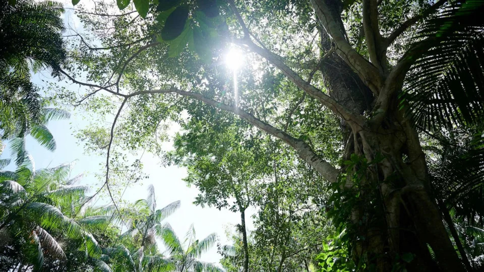
PHOTO: The sun shines through the rainforest near Belem, Brazil, June 7, 2023. (Picture Alliance via Getty Images)
This study is really the first to establish the limits of these tropical forest canopies, Goldsmith said.
The analysis indicates that tropical forests may be approaching the maximum temperature threshold for photosynthesis to work, the researchers found.
Researchers used high-resolution measurements taken from an instrument on board the International Space Station between 2018 and 2020. They also placed sensors on top of tree canopies in places like Brazil, Puerto Rico and Australia to estimate peak tropical-forest canopy temperatures.
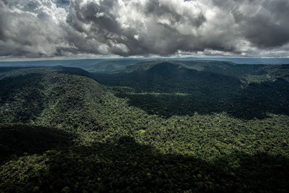
PHOTO: The National Forest in the Carajas mountain range, Para state, Brazil, May 17, 2023. (Dado Galdieri/Bloomberg via Getty Images)
They found many of the leaves are approaching a critical temperature threshold, according to Christopher Doughty, a professor in infomatics, computing and cyber systems and lead author of the study.
The data shows that canopy temperatures peaked at around 34 degrees Celsius — or 93.2 degrees Fahrenheit — on average, although a small proportion of those observed exceeded 40 degrees Celsius, or 104 degrees Fahrenheit.
Researchers are “just starting to see” these temperatures light up throughout forests, Joshua Fisher, a climate scientist with a focus on terrestrial ecosystems at Chapman University, told reporters at Monday’s news conference.
The percentage of leaves that began to fail was small — just an estimated .01% of all leaves in the forests studied, according to the study. But warming experiments predict this value will rise to 1.4% under future warming conditions.
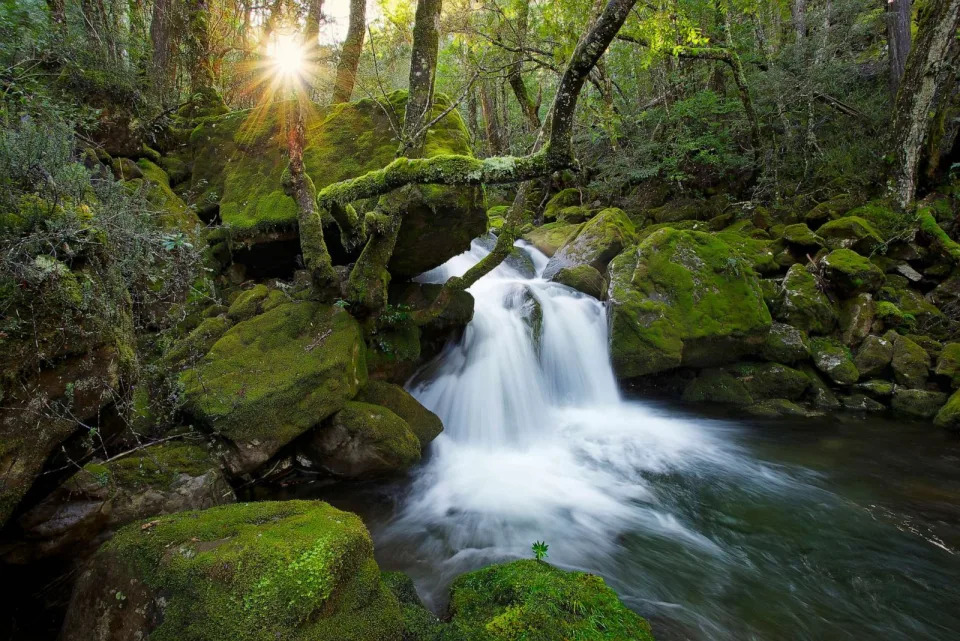
PHOTO: Falls on Mother Cummings Rivulet in Meander Forest Reserve, Great Western Tiers, Tasmania, Australia. (Auscape/Universal Images Group via Getty)
The critical temperature beyond which photosynthetic machinery in tropical trees begins to fail averages at about 46.7 degrees Celsius or about 116 degrees Fahrenheit.
Modeling suggests that tropical forests can withstand up to a 3.9 degree Celsius increase over current air temperatures before a potential tipping point is reached, which is within the worst-case scenario for climate predictions and possible, the researchers found.
“There’s a potential for a tipping point in these forest,” Doughty said.
PHOTO: A trail in the rain forest of El Yunque National Forest, Puerto Rico, Jan. 1, 2011. (Diego Cupolo/NurPhoto via Getty Images)
Known as the the carbon sinks of the world, tropical forests serve as critical carbon storage due to their capture and pack away carbon dioxide from the atmosphere. In addition, they hold most of the world species, which is why it is important to understand future temperatures and tropical forests, Doughty said.
“There’s all sorts of potential feedbacks once you start losing bits of forest,” he said.
Ambitious climate change mitigation goals and reduced deforestation are needed to help forests stay below thermally critical thresholds, the authors found.
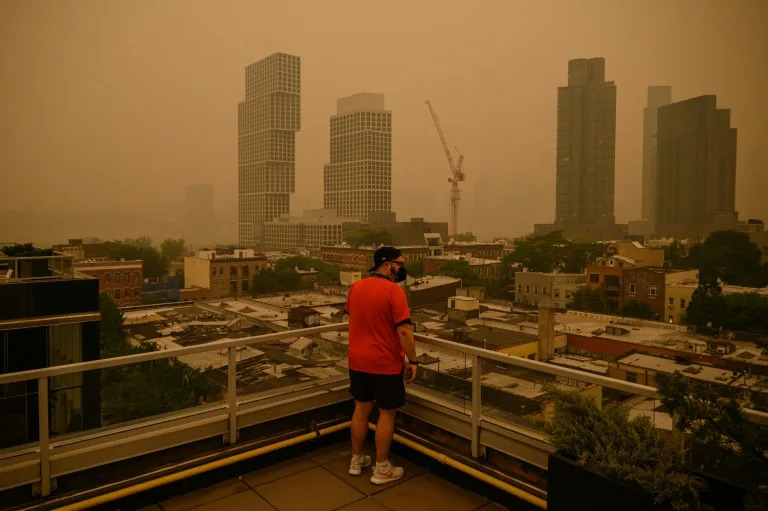
Heavy smog covers the skylines of the boroughs of Brooklyn and Manhattan in New York on June 7, 2023 (Ed JONES)
From Quebec to British Columbia to Hawaii, North America is facing an extraordinary wildfire season — and regions both near and far have found themselves increasingly blighted by smoke exposure.
Here’s what you should know about air pollution from these blazes.
– What we know –
One of the defining aspects of smoke from wildfires is “particulate matter” — toxins that, in their numbers, can make smoke visible.
Particulate matter of 2.5 micron diameter, PM2.5, is “particularly dangerous for human health and emitted in really large quantities,” Rebecca Hornbrook, an atmospheric chemist at the National Center for Atmospheric Research, who flies in planes through smoke for her research, told AFP.
“Typically if you are downwind of a wildfire, that’s the thing that’s causing the majority of the darkening of the sky and the lack of visibility,” she said, such as the shrouded skies seen in New York as a result of fires hundreds of miles away in Quebec earlier this year.
PM2.5 penetrates deep inside the lungs and potentially even the bloodstream.
The average American had already been exposed to 450 micrograms of smoke per cubic meter by early July, worse that the entirety of the years from 2006-2022, economist Marshall Burke at Stanford posted on X recently, citing calculations made by the university’s Environmental Change and Human Outcomes Lab.
Also of concern are invisible substances known as volatile organic compounds such as butane and benzene. These cause eye and throat irritation, while some are known carcinogens.
When VOCs mix with nitrogen oxides — which are produced by wildfires but also are abundant in urban areas from burning fossil fuels — they help form ozone which can exacerbate coughing, asthma, sore throat and difficulty breathing.
– What we don’t know –
Automobile ownership exploded after World War II, and in the decades since scientists have gained insights on how it impacts humans — from the onset of asthma in childhood to increased risk of heart attacks and even dementia later on in life.
That breadth of knowledge is lacking for wildfire smoke, explained Christopher Carlsten, director of the Air Pollution Exposure Laboratory at the University of British Columbia.
Based on the two dozen studies published “there seems to be a greater proportion of respiratory versus cardiovascular effects of smoke as compared to traffic pollution,” he told AFP.
The reason might be that nitric oxides are more prominent in traffic pollution.
Carlsten’s lab has begun conducting human experiments with wood smoke to gain more clarity.
Medical interventions exist, said Carlsten, who is also a physician, including inhaled steroids, non-steroid inflammatories, and air filters — but research is urgently needed to know how best to use them.
– Will it spur action? –
The warming planet also impacts our psychological wellbeing in myriad ways, Joshua Wortzel, chair of the American Psychiatric Association’s committee on climate change in mental health, told AFP.
One response is distress, “anger, grief, anxiety, in the face of the natural disasters they expect to come,” with these rates far higher in younger people than older.
Another is mental “acclimatization,” a byproduct of evolution that helps us cope with new stressors, but if we’re not careful can inure us to dangers, much like the proverbial frog in boiling water.
For Hornbrook, who is based in Colorado, what eastern North America experienced in 2023 is what the western side of the continent has already been dealing with for many years — and the global picture is only set to worsen given humanity’s appetite for burning fossil fuels.
While historic pollution regulations helped rein in emissions from cars and industry, climate action will be needed to tackle the wildfire scourge, she said.
“It gets frustrating knowing that we’ve been ringing the warning bell for years and years, and we’re now seeing what we’ve been warning about,” she said, but added there was still hope. “Maybe now people are actually starting to notice and we’ll see some change.”
Flooding overtakes Palm Springs, California, during Hilary as local emergency declared
Hillary Andrews – August 21, 2023
PALM SPRINGS, Calif. – A local emergency was declared in Palm Springs, California, Sunday afternoon as flash flooding from Hilary overwhelmed the city.
The desert resort city so far received more than a half-year’s worth of rain in less than a day. As of early evening, the NWS recorded 2.64 inches since early morning. The city only sees an average of 0.14 inches each August and 4.61 inches a year. No monthly average exceeds 1.15 inches.
“Due to unprecedented rainfall and flooding of local roadways and at least one swift water rescue, City Manager Scott Stiles has declared a local emergency due to the critically dangerous impacts,” announced the City of Palm Springs on X, the company formerly known as Twitter.
The city reported that 911 was down in the overnight hours.
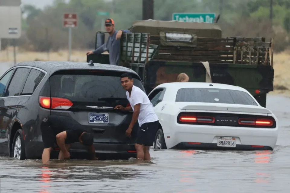
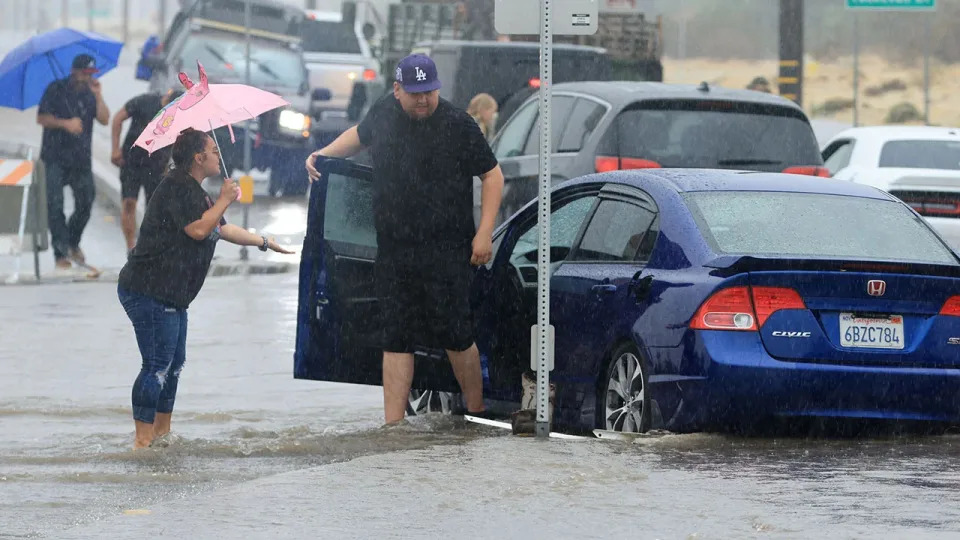
Motorists deal with a flooded road and stuck vehicles during heavy rains from Tropical Storm Hilary in Palm Springs, California, on August 20, 2023. Heavy rain lashed California on August 20 as Tropical Storm Hilary approached from Mexico, bringing warnings of potentially life-threatening flooding in the typically arid southwestern United States.More
The Palm Springs Fire Department shared a video of the raging wash over major city roads. They closed at least five roads because they were underwater.
More cars in Palm Springs were trapped as well by floodwaters. Cars stalled, and drivers tossed off shoes and tried to help each other in the calf-deep water. This was the first-ever Tropical Storm Warning for Southern California.
Motorists deal with a flooded road and stuck in vehicles during heavy rains from Tropical Storm Hilary in Palm Springs, California, on August 20, 2023.
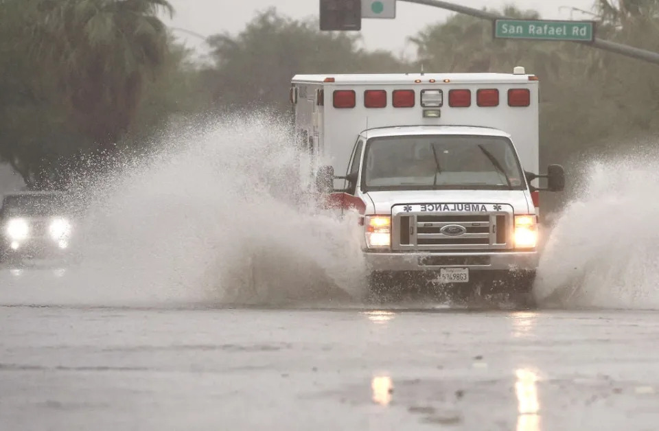
First responders coming to the aid of those stranded by the flooding had some issues themselves. This ambulance looked more like it was on a log flume instead of a city street.
PALM SPRINGS, CALIFORNIA – AUGUST 20: An ambulance drives through a flooded street as Tropical Storm Hilary approaches on August 20, 2023 in Palm Springs, California. Southern California is under a first-ever tropical storm warning as Hilary nears, with parts of California, Arizona and Nevada preparing for flooding and heavy rains. All California state beaches have been closed in San Diego and Orange counties in preparation for the impacts from the storm, which was downgraded from hurricane status.More
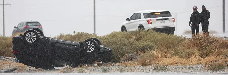
Roads became slick from the rain. A film of oil and the detergents in gasoline accumulates and coats the asphalt during the dry season. Before rain fell heavy enough to wash it away, the streets proved too slippery for this car.
First responders keep watch near a vehicle that flipped over during rainfall from approaching Tropical Storm Hilary on August 20, 2023 near Palm Springs, California.
Car parts floated down flooded streets in nearby Coachella.
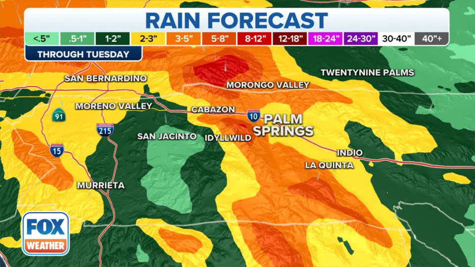
Sunday already set a record for the wettest August day in history for Palm Springs. The previous record has been held since 1930. And more rain is on the way. The FOX Forecast Center calls for 3 to 5 inches total for the city before Hilary departs.
The highest rainfall amounts are on the highest elevation of the mountains cradling Palm Springs and the entire Coachella Valley.
California’s unique mountainous geography, which tourists and residents flock to enjoy, is working against the helpless desert valley.
“That rain is going to be forced up along some of those mountains, especially east of San Diego,” explained Meteorologist Michael Estime. “And that’s going to create what we call orographic lift. And as moisture is lifted up the mountains, it’s it is then going to condense, and it’s going to get squeezed out like a wet washcloth over these areas again, east of the mountains.”
The extreme wind gusts with Hilary, already up to 84 mph on Big Black Mountain, blow south-southwesterly and lift the moisture and heavy rain on normally dry west slopes, explained the FOX Weather Forecast Center.
Palm Springs sits at the foot of 10,000-foot Mount Jacinto, according to the Bureau of Tourism. Gravity will force the water downhill, where it will overwhelm already taxed spillways, washes and gullies.
Water exploded through a low-lying road so fast that this truck in Thousand Palms, part of the Coachella Valley, couldn’t escape. The driver was trapped.
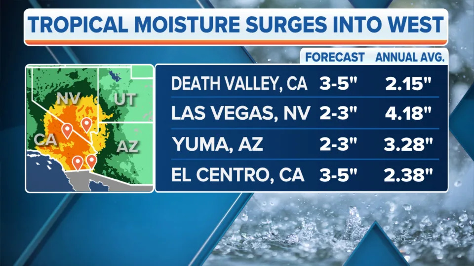
While Palm Springs braces for a year of rain from this one storm, some arid cities will see several years worth of rain in just a day before Hilary departs.