‘We live in a desert. We have to act like it’: Las Vegas faces reality of drought

‘We live in a desert. We have to act like it’: Las Vegas faces reality of drought

<span>Photograph: David McNew/Getty Images</span>
Photograph: David McNew/Getty Images


Investigator Perry Kaye jammed the brakes of his government-issued vehicle to survey the offense. “Uh oh this doesn’t look too good. Let’s take a peek,” he said, exiting the car to handle what has become one of the most existential violations in drought-stricken Las Vegas – a faulty sprinkler.

Kaye is one of nearly 50 water waste investigators deployed by the local water authority to crack down on even the smallest misuse of a liquid perilously scarce in the US west, desiccated by two decades of drought. The situation in Las Vegas, which went a record 240 consecutive days without rain last year, is increasingly severe.

Lake Mead, the vast reservoir that supplies Las Vegas with 90% of its water, has now plummeted to a historic low, meaning Nevada faces the first ever mandatory reduction in its water supply next year. This looming cutback is forcing restrictions upon the city that has somehow managed to thrive as a gaudy oasis in the baking Mojave desert.

Related: ‘A scourge of the Earth’: grasshopper swarms overwhelm US west

“The lake isn’t getting any fuller at this time so we need to conserve every single drop,” said Kaye, an energetic former US air force serviceman who wears a hi-vis vest and brandishes a badge as he does his rounds searching for violators. He starts his shift at 4am. “A lot of people think because we are government workers we are not out there at that time but we are out 24/7, every day of the year,” he said.

Kaye regularly hands out fines – they start at $80 and then double for each further offense – for the sort of rule-breaking he has spotted in Summerlin, a wealthy Las Vegas enclave where landscapers tend manicured grounds in the soaring heat. Water sprayed on to lawns and plants isn’t allowed to flow off the property, but that day a damaged sprinkler had caused water to cascade into the gutter, where the precious resource is lost.

“Look, we’ve got a little creek or stream here,” said Kaye, as he used his phone to video the water snaking on to the road. “If everyone did this, quite a bit of water would be wasted.”

It’s so hot in Vegas – this July day’s temperature will breach 40C (104F) – that the errant water will evaporate within five minutes. Kaye planted a yellow flag next to the leak as a warning to the homeowners but a few taps on the computer mounted in his cruiser shows this property has a previous warning, so an $80 fine will be on its way.

There’s a growing realization, however, that such rules – no watering between 11am and 7pm, none at all on Sundays – won’t be sufficient as Nevada is squeezed by a drought that has escalated dangerously in 2021. In June, the state passed a law to rip up “non-functional” public turf in Las Vegas, such as grass planted beside roads or on roundabouts, over the next five years to save around 10% of city water use.

“That is just wasteful – the only person who walks on that is the person who cuts it,” said Kaye, jabbing a finger at a nearby grass verge median. “Some people just want to recreate home, where they grew up with grass.” The new law, along with a financial incentive given to homeowners to replace thirsty grass with more hardy desert plants and rocks, is an acknowledgment that climate change won’t easily allow the imposition of a verdant green oasis upon a bone-dry desert basin.

A city that contains a huge replica of the Eiffel tower, sprawling golf courses and a simulacrum of Venetian canals complete with gondolas can never be said to fit in with its surroundings. But Las Vegas, called “The Meadows” in Spanish due to its natural springs that were pumped dry by the 1960s, is at least aware of its setting in a place so arid that only a few small creosote bushes and tumbleweeds can survive here naturally.

“We live in the desert. We are the driest city in the United States, in the driest state in the United States,” said Colby Pellegrino, deputy manager of resources for the Southern Nevada Water Authority. “We have to act like it.”

Pellegrino said the recent escalation of the drought has been “very scary” for some Vegas residents, although she insists the water authority has planned for this moment. Lake Mead’s level dropped under 1,075ft in June, barely a third full, triggering what will be the first ever cutbacks under a seven-state agreement on sharing the water from the Colorado River, which is harnessed by the Hoover dam to create the reservoir.

Different states get different water allocations and Nevada is a victim of its depopulated history, getting just 300,000 acre-feet of water a year (by comparison California gets 4.4m acre-feet) under an agreement struck before the Hoover dam was completed in the 1930s. “The joke is that Nevada’s representative was drunk,” said Pellegrino, who was born in 1983, when the state’s population was barely 900,000. It’s now more than 3m and receives tens of millions of tourists a year.

Houses, trees and swimming pools spring from the desert in Henderson, Nevada.
Houses, trees and swimming pools spring from the desert in Henderson, Nevada. Photograph: David McNew/Getty Images


This small water allocation will shrink by 21,000 acre-feet with the new cuts, although Nevada has made impressive strides in keeping below its low cap, slashing its water use despite the population nearly doubling since the early 2000s. Pellegrino is confident that further savings can be made and scrutiny is being placed upon the water used in Vegas casinos’ ubiquitous cooling systems.

But global heating’s impact upon the west’s snowpack and rivers is unrelenting and the city’s water savings will only go so far. Las Vegas only has a supporting role in its own fate. Three-quarters of allocated Colorado River water is used to irrigate thirsty agriculture, and the overall water supply is more dependent upon the amount of snow melting hundreds of miles away in the Rocky Mountains than some extra marginal savings made in the suburbs.

“Vegas has done great things such as ripping out the grass, but we’ve lost 20% of the flow of the Colorado River since 2000 and another 10% loss by 2050 is completely possible,” said Brad Udall, a water and climate scientist at Colorado State University whose research has focused on the stresses facing the river.

“I worry it could be even more than that, and that should frighten everyone.”

Back in Summerlin, Perry Kaye is also relentless. A house opposite the first offender has broken sprinklers splurging water into puddles on the grass and road. Kaye bangs on the ornate door to inform the homeowner, but no one is in.

“These sprinklers haven’t popped up properly, they are just oozing everywhere,” muttered Kaye. He has been policing water waste for the past 16 years, issuing countless fines in that time. “I had hoped I would’ve worked myself out of a job by now. But it looks like I will retire first.”

Along St. Petersburg’s waterfront, the park is quiet but the smell is strong

Along St. Petersburg’s waterfront, the park is quiet but the smell is strong


ST. PETERSBURG — The 9 a.m. bayside air reeked of dead fish.

Megan McDonald smelled it as she approached the park with her friend’s two dogs, and walked up to the concrete seawall and looked down at the water. There were thousands of tarpon and snook floating sideways.

“I didn’t expect it to be like this,” said McDonald, 27.

The six volleyball courts, usually full, had only two in use.

“Where is everybody?” a passerby asked between points.

“Red Tide,” replied a player.

Normally packed on a Saturday morning in July, the stench was strong and the scene was quiet at Vinoy Park as thousands of dead fish lined the seawall, spread out into the bay and turned St. Petersburg’s bayside into one of the state’s epicenters for Red Tide.

The scattered blooms of the organism that causes Red Tide, Karenia brevis, is concentrated near St. Petersburg’s beaches and parks. Of the 15 tons of dead fish the city has collected in the past 10 days, city officials believe nine were blown in by Tropical Storm Elsa, St. Petersburg Emergency Manager Amber Boulding said at a Friday news conference.

Crews stood on the edge of the seawall, scooping fish in their nets, adding to the nine tons of fish they collected in the previous 24 hours. The volleyball nets soon emptied. A biker sped along the sidewalk, one hand on the handlebar and the other on her nose.

One couple walked over to see the damage. Morgan Janssen had told Freddy Hensley about the strong stench and closed businesses that Red Tide blooms from 2017 to 2019 had caused along the Gulf Coast. Hensley visited to see a widespread outbreak for the first time.

“I wanted to show him this morning because I was like, ‘No, you have to believe me. There’s fish everywhere,’” Janssen said as Hensley scooped at the fish with a tree branch.

Others continued their normal routines. Along his favorite breezy spot at the park, Al Nixon sat on his bench, resting his arm on its back and greeting passersby like always.

He visits Vinoy Park every day, a friendly face to some and a confidant to others, but lately, he’s seen less foot traffic than normal. He noticed people “just trying to get through the walk” because of the smell. For some people who stopped to chat, the conversation often led to the stench of the water.

“It doesn’t change my mood. I’m just a play-it-by-ear, why-be-sad type of person,” he said. “It’s somewhat disappointing because you don’t see the people that you normally see and have normal chats with.”

Pinellas County helped city efforts in cleaning up waterways and beaches in St. Petersburg, Mayor Rick Kriseman said in a Saturday morning Facebook post. The city called on a debris removal contractor that usually helps with storms to clean the debris. It also sought assistance from the state.

Dead fish are also popping up in Treasure Island, scattered mostly one-by-one instead of in groups, several people who lead beach cleanups said. The Bay Side Yacht Club, a cleanup group from a cul-de-sac on Bay Plaza, met for free eggs and bacon at Caddy’s before starting their monthly beach cleanup.

City crews picked up the dead fish, but what bothered Richard Harris the most was what had caused one of the more pervasive problems from storms: the cigarette butts that Elsa had pushed to the high tide line.

“Last month, during the month of June, when I did the cleanup, I picked up 271 (cigarette butts),” he said just after 10 a.m. “Today, I’m up to 535.” (He ended the morning with 821).

As noon approached in Vinoy Park, Daniel Larouche sat in his hammock, next to a candle he lit to keep the flies away. He sleeps in the hammock most nights by a lake, then walks 30 minutes each morning to the edge of the park, where there’s a bathroom he can use and cold water fountains. He grew up in St. Petersburg, working various jobs, but ended up homeless. Vinoy Park is his go-to spot.

“A lot of people you see walking, they’re in air conditioning most of their lives. So they come out here for 20 minutes or 30 minutes to walk,” he said. “And they don’t really feel that smell. You just get used to it.”

He set up at the edge of the park, far enough where if the air is still, coffee and cigarettes can help dull the smell of the water. It was “kind of, sort of” less crowded than normal away from the main sidewalk, he said.

Fitness classes came and went. It would clear out more as the afternoon heat approaches. Crews would continue to net the fish. Eventually, the smell would return to normal.

But not on Saturday.

“There’s only so much (the city) can do,” Larouche said.

Red Tide resources

There are several online resources that can help residents stay informed and share information about Red Tide:

Florida Poison Control Centers have a toll-free 24/7 hotline to report illnesses, including from exposure to Red Tide: 1-800-222-1222

To report fish kills in St. Petersburg, call the Mayor’s Action Center at 727-893-7111 or use St. Petersburg’s seeclickfix website.

Visit St. Pete/Clearwater, the county’s tourism wing, runs an online beach dashboard at www.beachesupdate.com.

The agency asks business owners to email reports of Red Tide issues to pr@visitspc.com.

Pinellas County shares information with the Red Tide Respiratory Forecast tool that allows beachgoers to check for warnings.

The Florida Fish and Wildlife Conservation Commission has a website that tracks where Red Tide is detected and how strong the concentrations.

How to stay safe near the water
  • Beachgoers should avoid swimming around dead fish.
  • Those with chronic respiratory problems should be particularly careful and “consider staying away” from places with a Red Tide bloom.
  • People should not harvest or eat mollusks or distressed and dead fish from the area. Fillets of healthy fish should be rinsed with clean water, and the guts thrown out.
  • Pet owners should keep their animals away from the water and from dead fish.
  • Residents living near the beach should close their windows and run air conditioners with proper filters.
  • Visitors to the beach can wear paper masks, especially if the wind is blowing in.

Source: Florida Department of Health in Pinellas County

St. Petersburg cleans up 9 tons of dead fish in 24 hours due to Red Tide, Elsa

St. Petersburg cleans up 9 tons of dead fish in 24 hours due to Red Tide, Elsa

ST. PETERSBURG — The city’s shoreline was besieged by dead fish and Red Tide blooms.


The sidewalk along the shore at North Shore Park reeked of death Friday. Just off into the water, crews in yellow jumpsuits and tall rubber boots scooped dead fish off the top of the water with pool skimmers, put them into trash bags and loaded them into a dump truck. Hundreds of dead fish were still out there, floating just a few feet from shore.

Crews picked up 9 tons of dead fish in 24 hours — and they weren’t even done.

The fish were killed by toxic Red Tide blooms and then pushed ashore by Tropical Storm Elsa, said St. Petersburg Emergency Manager Amber Boulding at a Friday news conference. The city has collected 15 tons of dead fish in the past 10 days, she believes the 9 tons that recently washed ashore was blown in by the storm’s winds.

“You look at Elsa and that push of water from the wind seems to have definitely pushed in more of the fish kill,” Boulding said.

The conclusion to Justin Bloom, a board member for the environmental groups Tampa Bay and Suncoast Waterkeeper, is inescapable:

“Tampa Bay is really sick right now, really extraordinarily bad. Conditions that we haven’t seen in decades.”

Several high concentrations of Karenia brevis, the microorganism that causes Red Tide blooms, also dot St. Petersburg’s shore. They were detected in water samples taken off Vinoy Park, Bayboro Harbor, Big Bayou and Coquina Key, according to the Florida Fish and Wildlife Conservation Commission’s Red Tide map.

The result, Boulding said, is that St. Petersburg is seeing a greater number of fish kills than the massive 2017-19 Red Tide outbreak that crushed the county’s tourism industry and led to more than 1,800 tons of dead marine life to wash up onto the Pinellas beaches. But that outbreak afflicted the Gulf of Mexico side of the Pinellas coast, while the current outbreak is on the Tampa Bay side, which affects St. Petersburg the most.

“It’s very serious,” Boulding said.

Bloom believes the April Piney Point disaster helped fuel strong, harmful Red Tide blooms. The owner of the Manatee County fertilizer plant released 215 million gallons of polluted wastewater into Tampa Bay. Scientists are studying whether the release fueled the algal blooms.

The most impacted areas, according to St. Petersburg officials, were along the east and southeast coast from Tierra Verde to Gandy Boulevard.

Boulding said aerial footage of Tampa Bay has shown there is a lot more dead fish in the water waiting that will need to be cleaned after it comes ashore. While she assured residents and tourists that crews are working as fast as they can, she said this isn’t a problem that will be resolved quickly.

The city’s efforts are “at the mercy” of the winds and tides pushing Red Tide blooms and dead fish piles around the bay, she said.

Boulding said residents and visitors can see the dead fish on their morning runs and smell them the moment they step outside. Officials don’t know when the current situation will get better. Pinellas County officials say that, including St. Petersburg, the county has collected 427 tons of dead marine life and debris.

“What makes our city so wonderful is all of our waterfront,” Boulding said. “And that also is what makes it so tough when it comes to tackling Red Tide.”

Crews of about 120 people from across city departments are on clean-up duty. The effort started last week but paused as workers helped distribute sandbags in advance of Elsa. When the storm passed by, she said, they went back out cleaning fish.

The focus on the clean-up has delayed other city services like roadway mowing, tree trimming and pot hole repairs.

Boulding asks anyone who sees dead fish on land or in the water to report it by calling the Mayor’s Action Center at 727-893-7111 or through St. Petersburg’s seeclickfix website.

Red Tide resources

There are several online resources that can help residents stay informed and share information about Red Tide:

Florida Poison Control Centers have a toll-free 24/7 hotline to report illnesses, including from exposure to Red Tide: 1-800-222-1222

Visit St. Pete/Clearwater, the county’s tourism wing, runs an online beach dashboard at www.beachesupdate.com.

The agency asks business owners to email reports of Red Tide issues to pr@visitspc.com.

Pinellas County shares information with the Red Tide Respiratory Forecast tool that allows beachgoers to check for warnings.

The Florida Fish and Wildlife Conservation Commission has a website that tracks where Red Tide is detected and how strong the concentrations.

How to stay safe near the water
  • Beachgoers should avoid swimming around dead fish.
  • Those with chronic respiratory problems should be particularly careful and “consider staying away” from places with a Red Tide bloom.
  • People should not harvest or eat mollusks or distressed and dead fish from the area. Fillets of healthy fish should be rinsed with clean water, and the guts thrown out.
  • Pet owners should keep their animals away from the water and from dead fish.
  • Residents living near the beach should close their windows and run air conditioners with proper filters.
  • Visitors to the beach can wear paper masks, especially if the wind is blowing in.

Source: Florida Department of Health in Pinellas County

Yellowstone Is Losing Its Snow, with Repercussions for Everyone Downstream

InTheseTimes – Rural America

Yellowstone Is Losing Its Snow, with Repercussions for Everyone Downstream

A climate assessment found that snowfall is declining in Greater Yellowstone — and likely to keep declining. The problems trickle down to impact everyone from trout to grizzly bears to people.

Bryan Shuman                    July 7, 2021

Bison walk the prairie beneath Electric Peak in Yellowstone National Park. PHOTO BY JACOB W. FRANK / NATIONAL PARK SERVICE

Editor’s Note: This article is republished from The Conversation under a Creative Commons license. Read the original article.

When you picture Yellowstone National Park and its neighbor, Grand Teton, the snowcapped peaks and Old Faithful Geyser almost certainly come to mind. Climate change threatens all of these iconic scenes, and its impact reaches far beyond the parks’ borders.

A new assessment of climate change in the two national parks and surrounding forests and ranchland warns of the potential for significant changes as the region continues to heat up.

Since 1950, average temperatures in the Greater Yellowstone Area have risen 2.3 degrees Fahrenheit (1.3 C), and potentially more importantly, the region has lost a quarter of its annual snowfall. With the region projected to warm 5 – 6 F by 2061 – 2080, compared with the average from 1986 – 2005, and by as much as 10 – 11 F by the end of the century, the high country around Yellowstone is poised to lose its snow altogether.

The loss of snow there has repercussions for a vast range of ecosystems and wildlife, as well as cities and farms downstream that rely on rivers that start in these mountains.

Broad impact on wildlife and ecosystems

The Greater Yellowstone Area comprises 22 million acres in northwest Wyoming and portions of Montana and Idaho. In addition to geysers and hot springs, it’s home to the southernmost range of grizzly bear populations in North America and some of the longest intact wildlife migrations, including the seasonal traverses of elk, pronghorn, mule deer and bison.

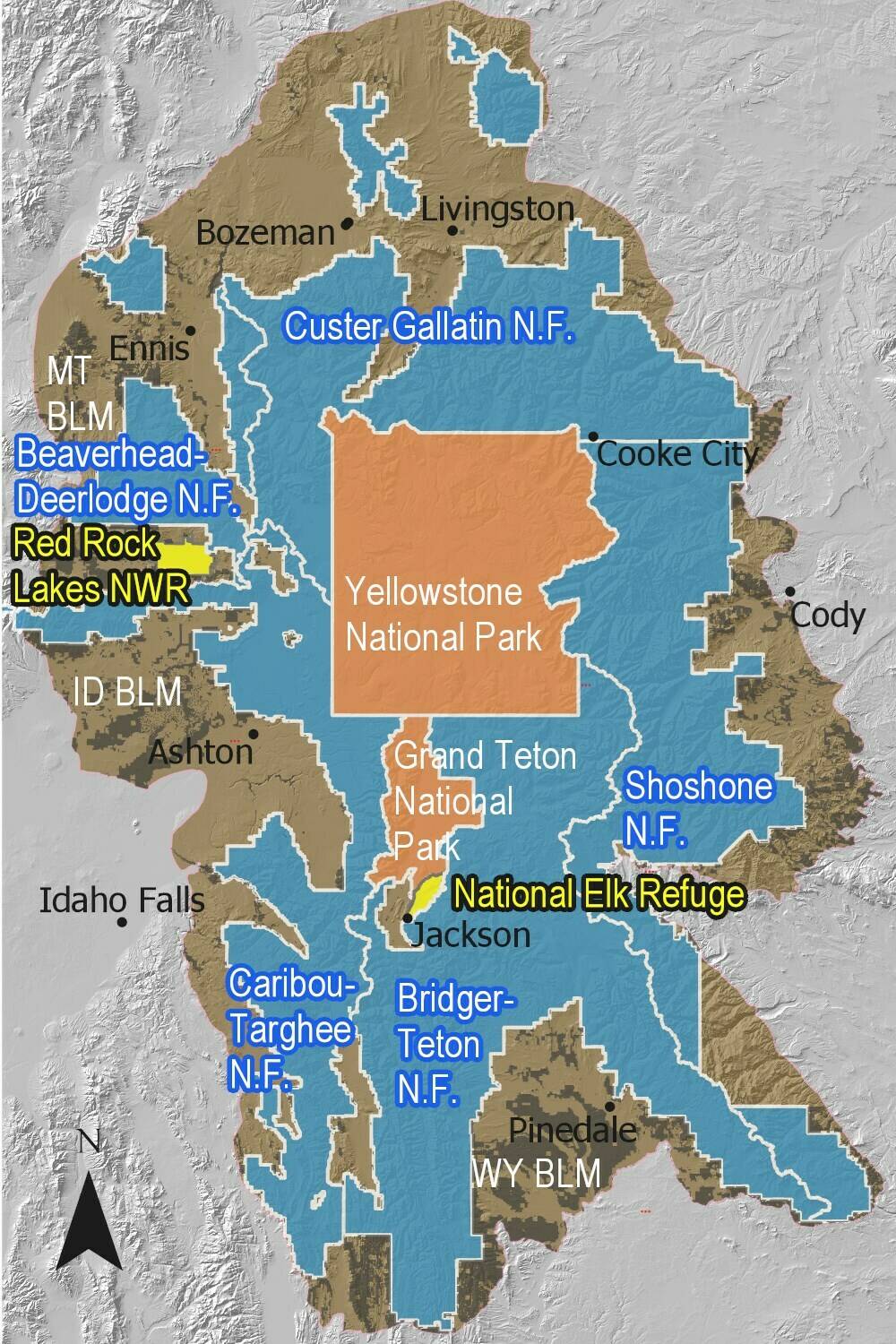
The Greater Yellowstone Area includes both Yellowstone and Grand Teton national parks, as well as surrounding national forests and federal land. MAP COURTESY OF THE NATIONAL PARK SERVICE


The area also represents the one point where the three major river basins of the western U.S. converge. The rivers of the Snake-Columbia basin, Green-Colorado basin, and Missouri River Basin all begin as snow on the Continental Divide as it weaves across Yellowstone’s peaks and plateaus.

How climate change alters the Greater Yellowstone Area is, therefore, a question with implications far beyond the impact on Yellowstone’s declining cutthroat trout population and disruptions to the food supplies critical for the region’s recovering grizzly population. By altering the water supply, it also shapes the fate of major Western reservoirs and their dependent cities and farms hundreds of miles downstream.

Rising temperatures also increase the risk of large forest fires like those that scarred Yellowstone in 1988 and broke records across Colorado in 2020. And the effects on the national parks could harm the region’s nearly $800 billion in annual tourism activity across the three states.

A group of scientists led by Cathy Whitlock from Montana State University, Steve Hostetler of the U.S. Geological Survey and myself at the University of Wyoming partnered with local organizations, including the Greater Yellowstone Coalition, to launch the climate assessment.

We wanted to create a common baseline for discussion among the region’s many voices, from the Indigenous nations who have lived in these landscapes for over 10,000 years to the federal agencies mandated to care for the region’s public lands. What information would ranchers and outfitters, skiers and energy producers need to know to begin planning for the future?

Less water in rivers can harm cutthroat trout, which grizzly bears and other wildlife rely on for food. Climate change also threatens white bark pines, high-elevation trees that historically provided an important food source for Yellowstone grizzlies. PHOTO BY KAREN BLEIER/AFP VIA GETTY IMAGES
Shifting from snow to rain

Standing at the University of Wyoming-National Park Service Research Station and looking up at the snow on the Grand Teton, over 13,000 feet above sea level, I cannot help but think that the transition away from snow is the most striking outcome that the assessment anticipates – and the most dire.

Today the average winter snowline – the level where almost all winter precipitation falls as snow – is at an elevation of about 6,000 feet. By the end of the century, warming is forecast to raise it to at least 10,000 feet, the top of Jackson Hole’s famous ski areas.

The climate assessment uses projections of future climates based on a scenario that assumes countries substantially reduce their greenhouse gas emissions. When we looked at scenarios in which global emissions continue at a high rate instead, the differences by the end of century compared with today became stark. Not even the highest peaks would regularly receive snow.

In interviews with people across the region, nearly everyone agreed that the challenge ahead is directly connected to water. As a member of one of the regional tribes noted, ​Water is a big concern for everybody.”

Precipitation may increase slightly as the region warms, but less of it will fall as snow. More of it will fall in spring and autumn, while summers will become drier than they have been, our assessment found.

The timing of the spring runoff, when winter snow melts and feeds into streams and rivers, has already shifted ahead by about eight days since 1950. The shift means a longer, drier late summer when drought can turn the landscape brown – or black as the wildfire season becomes longer and hotter.

The outcomes will affect wildlife migrations dependent on the ​green wave” of new leaves that rises up the mountain slopes each spring. Low stream flow and warm water in late summer will threaten the survival of coldwater fisheries, like the Yellowstone cutthroat trout, and Yellowstone’s unique species like the western glacier stonefly, which depends on the meltwater from mountain glaciers.

Preparing for a warming future

These outcomes will vary somewhat from location to location, but no area will be untouched.

We hope the climate assessment will help communities anticipate the complex impacts ahead and start planning for the future.

As the report indicates, that future will depend on choices made now and in the coming years. Federal and state policy choices will determine whether the world will see optimistic scenarios or scenarios where adaption becomes more difficult. The Yellowstone region, one of the coldest parts of the U.S., will face changes, but actions now can help avoid the worst. High-elevation mountain towns like Jackson, Wyoming, which today rarely experience 90 F, may face a couple of weeks of such heat by the end of the century – or they may face two months of it, depending in large part on those decisions.

The assessment underscores the need for discussion. What choices do we want to make?

Bryan Shuman is professor of paleoclimatology and paleoecology at the University of Wyoming.

Wind and solar power surges in record year

Wind and solar power surges in record year

The sun sets behind power-generating turbines of a local wind farm in Crimea


China led a record increase in wind and solar power during 2020 – even as the emerging superpower continued to build new fossil-fuel burning coal plants.

Capacity of wind and solar power grew by 238GW globally last year, about 50pc larger than any previous expansion, according to the latest annual review of world energy by BP.

The jump in renewable output amounts to about seven times the total installed capacity in the UK, and came in a year marked by a slump in energy use as the pandemic triggered a slowdown in global travel.

China accounted for over half of the growth in wind and solar capacity. Some of the increase was driven by changes to the Chinese subsidy regime, which pulled projects forward, but BP said there was a significant increase even accounting for this.

Wind, solar and other renewable sources are on the rise as countries and companies pledge to slash their carbon emissions in line with the Paris agreements to cut global warming. Last year China said it would cut its emissions to net zero by 2060.

The share of renewable power, including wind and solar, in the global power mix also rose from 10.3pc to 11.7pc.

In Europe, that share reached 23.8pc, making it the first region where renewables are the main source of fuel, BP said.

The figures appear to allay concerns at the start of the pandemic that low oil prices and distracted politicians might slow down the push towards cleaner power.

Meanwhile the share of coal in power generation fell 1.3 percentage points to 35.1pc.

This is a record low share, although coal-fired generation overall is relatively flat compared to 2015.

Coal consumption among countries in the OECD club of developed nations fell to the lowest level recorded in BP’s annual review, which stretches back to 1965. However, coal consumption rose in China and Malaysia.

Despite its push on renewables, China approved 13GW of coal-fired plants, a 45pc increase on 2019 levels, last year, according to a report in June by the International Energy Agency.

Officials lowered restrictions on new plants to help the country recover from the pandemic.

Bernard Looney, chief executive of BP, said: “The relative immunity of renewable energy to the events of last year is encouraging.

“The challenge is to achieve sustained, comparable year-on-year reductions in emissions without massive disruption to our livelihoods and our everyday lives.”

The collapse in demand for energy, and particularly oil, during the pandemic led to a 6pc fall in carbon emissions from energy use, the largest decline since 1945, BP said.

However, this came at considerable cost, with GDP falling globally by more than 3.5pc.

Spencer Dale, BP’s chief economist, said: “Despite the turmoil, despite the collapse in world GDP, wind and solar just continue to grow.

“The increase in installed capacity last year is 50pc bigger than any time in history.”

BP is among several major companies pledging to slash their carbon emissions, and is investing more in renewables while cutting back on oil and gas production.

Dahlen, N.D., rancher deals with burnt-up pastures and low or empty water holes

Dahlen, N.D., rancher deals with burnt-up pastures and low or empty water holes


DAHLEN, N.D. — Grass crunched under Jeff Trenda’s boots as he walked across a parched pasture, where a herd of about 20 Angus-Simmental crossbred cows gathered under a tree as the temperature neared 90 degrees.

The combination of too much heat and too little rain dried up the pasture grass that usually would be green and lush in early summer. On this day, it’s brown and sparse.

Trenda’s situation echoes across North Dakota’s farms and ranches. North Dakota pasture and range conditions for the week ending Sunday, June 27, were rated 33% very poor, 32% poor, 27% fair and 8% good, according to the National Agricultural Statistics Service-North Dakota. Stock water supplies were rated 38% very short, 36% short and 26% percent adequate. No pasture or rangeland in North Dakota was rated excellent and there was no surplus of water in the state, the statistics service said.

In late June, Trenda already was resigned to the fact that this year’s summer grazing season would be greatly shortened.

“If we get to the first of August, we’ll be lucky,” Trenda said. Most years, he would leave the cows in the pasture until mid-October.

Because pasture conditions are poor late last month, half of his herd of 120 cow-calf pairs were still in a corral, where he was feeding them hay and silage.

“We’re trying to hold them in the yard to let the grass get a little longer,” Trenda said. He’s grateful that last winter was mild so he didn’t use all of the hay he baled in 2020.

This year’s hay crop is likely to be scanty, and Trenda figures he’ll get less than a third of the bales he usually does. He is hoping Conservation Reserve Program acres will be opened early for haying. If farmers and ranchers aren’t allowed to cut and bale CRP land until August, the quality of the grass, which generally isn’t good, will be even poorer, Trenda said.

“It’s going to be better than nothing, but it would be a lot better if we could get it earlier, quality-wise,” he said.

Trenda plans to sell 10 older cows in the next couple of weeks to ease pressure on his feed supply. It’s likely he’ll also have to sell some heifers that he wanted to keep and use as breeding stock.

The drought, besides damaging pastures, has resulted in dry or nearly dry water holes, like the one in his pasture east of Dahlen.

“There was water there a week ago when I put the cows in it, but now there’s nothing” Trenda said. The water hole not only was empty, but the top of the ground had cracked into brittle pieces, and the sides of the hole showed no signs of moisture.

Other pasture water holes have a small pool of water but it’s poor quality, and Trenda is concerned his cattle will get sick if they drink from them. He’s hauling water to his herd to ensure they have access to good water. For the past few weeks, Trenda has been filling a 3,000-gallon water trailer, pulling it to the pastures, and then pumping the water into troughs.

Two years ago, Trenda and his neighbors were struggling to cut corn silage because the fields were knee-deep in mud. That year, 2019, farmers banded together and modified manure spreaders and used them to haul their silage through the field.

“It’s a battle. Every day is a battle. You just don’t know what’ s going to happen,” he said.

Report: Great Lakes region needs about $2B for flood repairs

Report: Great Lakes region needs about $2B for flood repairs

FILE – In this Dec. 4, 2019 file photo, erosion reaches a house along Lake Michigan’s southwestern shoreline in Stevensville, Mich. Shoreline cities and towns in the Great Lakes region will be spending heavily in coming years to fix public infrastructure damaged by recent flooding and erosion, with estimated costs approaching $2 billion, officials said Thursday, June 8, 2021. (Robert Franklin/South Bend Tribune via AP. File)


TRAVERSE CITY, Mich. (AP) — Shoreline cities and towns in the Great Lakes region will be spending heavily in coming years to fix public infrastructure damaged by recent flooding and erosion, with estimated costs approaching $2 billion, officials said Thursday.

Communities already have poured about $878 million into repairs over the last two years, according to the results of a survey by the Great Lakes and St. Lawrence Cities Initiative, a coalition of mayors and local officials in the region’s eight states and two Canadian provinces.

But the survey of 241 cities, villages and other jurisdictions found that at least $1.94 billion more will be needed over the next five years. The total is certain to be even higher because the report didn’t include all shoreline municipalities, said Jon Altenberg, the initiative’s executive director.

“Communities around the Great Lakes face a growing crisis, and we need both the federal governments of the U.S. and Canada to assist with the necessary investments,” Milwaukee Mayor Tom Barrett said. “Our coastal infrastructure is vital to the economic and recreational health of our communities, and coordinated action is required.”

Abnormally high lake levels and severe rains since 2019 have hammered drinking water intake pipes, sidewalks, ports and docks. Parkland, beaches and wetlands have washed away. Portions of roads have crumbled.

Great Lakes levels fluctuate annually with the seasons and historically experience prolonged high- and low-water periods. But scientists say the warming climate may be making those multi-year swings more abrupt and extreme.

Lakes Huron and Michigan reached their lowest levels on record in early 2013, while the other Great Lakes — Superior, Erie and Ontario — were well below average. Then came a turnabout, as wetter weather filled the lakes to the brim. All five set record highs during the past two years.

Although levels have dipped this year, intense storms have brought flooding to some cities on the lakes or rivers connecting them, including Chicago and Detroit.

The cities group is joining other government, business and environmental organizations in pushing for the Great Lakes region to get a generous share of the infrastructure funding proposed by President Joe Biden and under consideration in Congress.

In addition to continued funding of the Great Lakes Restoration Initiative cleanup program established in 2010, the groups in a June 24 letter to congressional leaders requested billions for water and sewer upgrades, flood prevention and related needs.

“These investments will address longstanding basin-wide priorities while stimulating economic activity in hard-hit communities throughout our region,” the letter said.

Utah’s Great Salt Lake is in trouble

Axios

Utah’s Great Salt Lake is in trouble


Utah’s Great Salt Lake is in trouble, with serious ramifications for one of America’s fastest-growing areas.

Why it matters: It’s the largest natural lake west of the Mississippi River and has been shrinking for years, with the mega-drought making it even worse, reports AP’s Lindsay Whitehurst.

Get market news worthy of your time with Axios Markets. Subscribe for free.

  • The lake’s levels are expected to hit a 170-year low this year.
  • Wildlife is suffering from the decline, especially birds and shrimp.
Visitors stand in the shallow waters in June. Photo: Rick Bowmer/AP

The waves have been replaced by dry, gravelly lakebed that’s grown to 750 square miles. Winds can whip up dust from the dry lakebed that is laced with naturally occurring arsenic.

Tourism is also at risk: The dust from the lakebed could speed up snowmelt at Utah’s popular ski resorts.

  • And once-popular lakeside resorts are now long shuttered.

People swim at Saltair in 1933. The resort once drew sunbathers who would float like corks in the Great Salt Lake’s extra salty waters. Photo: Salt Lake Tribune via AP

The bottom line: To maintain lake levels, diverting water from rivers that flow into it would have to decrease by 30%.

  • But for the state with the nation’s fastest-growing population, addressing the problem will require a major shift in how water is allocated.

Sen. Ron Johnson mouths to GOP group that climate change is ‘bullsh–‘ just weeks before deadly heat wave

Sen. Ron Johnson mouths to GOP group that climate change is ‘bullsh–‘ just weeks before deadly heat wave

Sen. Ron Johnson, a Wisconsin Republican.
Sen. Ron Johnson, a Wisconsin Republican. Samuel Corum/Getty Images 

  • Ron Johnson mouthed to a GOP luncheon that climate change is “bullsh–,” CNN reported.
  • His comments came weeks before a fatal heat wave in the Pacific Northwest that scientists attributed to climate change.
  • Johnson has a long record of rejecting facts or making comments at odds with science on climate change.

Republican Sen. Ron Johnson of Wisconsin called climate change “bullsh–” during a GOP luncheon in early June, just weeks before a heat wave claimed dozens of lives in the Pacific Northwest. Scientists have linked the historic high temperatures to climate change.

“I don’t know about you guys, but I think climate change is – as Lord Monckton said – bullsh–,” Johnson said during the Republican Women of Greater Wisconsin Luncheon at Alioto’s in Wauwatosa, Wisconsin, in comments caught on video and first reported by CNN. “By the way, it is.”

Johnson – who referred to Lord Christopher Monckton, a climate skeptic who has held positions in the British government and press – did not actually say “bullsh–” out loud, but mouthed the word.

The Wisconsin senator defended himself in comments to CNN, rejecting the notion that he’s a climate change denier.

“My statements are consistent. I am not a climate change denier, but I also am not a climate change alarmist. Climate is not static. It has always changed and always will change,” Johnson said.

The world’s top scientists say that climate change is real and caused by human activities. In short, Johnson’s comments are not backed up by science.

Johnson further defended himself on Twitter, writing, “I do not share Rep. Ocasio-Cortez view that the ‘world is going to end in 12 years if we don’t address climate change.’ Or POTUS saying the ‘greatest threat’ to U.S. security is climate change. I consider those to be extreme positions – to say the least.”

The Wisconsin Republican was referencing remarks made by Democratic Rep. Alexandria Ocasio-Cortez of New York in January 2019. Ocasio-Cortez has said she did not mean the world would literally end in 12 years, and was referencing a United Nations report that said humans only had a dozen years to change their behavior and avoid a climate change catastrophe.

Johnson also dismissed President Joe Biden’s comments on the national security threat posed by climate change, which have been backed up by Chairman of the Joint Chiefs of Staff Gen. Mark Milley.

“Climate change is going to impact natural resources, for example,” Milley said during a Senate Armed Services Committee hearing in June. “It’s going to impact increased instability in various parts of the world. It’s going to impact migrations, and so on.”

Johnson has a long record of making statements at odds with science and denying that climate change is a product of human activities. In 2010, for example, Johnson falsely said Greenland only recently froze and erroneously suggested it was named for its previously green landscapes.

Farmworkers face dangerous conditions as heat waves scorch Western U.S.

Farmworkers face dangerous conditions as heat waves scorch Western U.S.

David Knowles, Senior Editor                           July 8, 2021


With temperatures expected to top 110 degrees in California’s Central Valley, and reach 120 degrees in the southern part of the state, migrant farmworkers will once again be forced to endure dangerous conditions born of climate change.

“Farmworkers really are at the frontlines of climate change,” Leydy Rangel, communications manager for the United Farm Workers Foundation told Yahoo News. “Unfortunately, that’s an issue that will not get better. We know that heat is the No. 1 cause of weather-related deaths in the U.S.”

When a heat dome descended over the Pacific Northwest last month, Sebastian Francisco Perez, a Guatemalan immigrant, was found unresponsive on June 26 at the farm where he had been working in 104-degree heat.

A farmer pulls a wind-felled almond tree with a tractor on an almond farm in Gustine, California, U.S., on Monday, June 14, 2021. (David Paul Morris/Bloomberg via Getty Images)


In response, Oregon Gov. Kate Brown directed the state’s workplace safety agency to implement rules designed to protect workers from extreme heat.

“All Oregonians should be able to go to work knowing that conditions will be safe and that they will return home to their families at the end of the day,” Brown said in a statement. “While Oregon OSHA has been working to adopt permanent rules related to heat, it became clear that immediate action was necessary in order to protect Oregonians, especially those whose work is critical to keeping Oregon functioning and oftentimes must continue during extreme weather.”

California’s heat standards — which mandate clean drinking water for workers, breaks and access to shade — were put in place following the 2008 death of Maria Isabel Vasquez Jimenez, a 17-year-old migrant worker from Oaxaca, Mexico. Unaware that she was pregnant, she died while while harvesting grapes at a farm near Stockton, Calif., in temperatures near 100 degrees.

“Farmworkers have been excluded from many of the rights and benefits that protect other workers partly because they are immigrants and don’t have legal status,” Rangel said.

During last month’s heat dome event in the Pacific Northwest, which killed hundreds of people across the region, the UFW conducted a text-message survey of agricultural workers in Washington state. While the results are still preliminary and have not yet been published, Rangel told Yahoo News that of the 1,875 workers who responded, 56 percent reported experiencing symptoms associated with heat illness while on the job, 26 percent said they were not being provided with cool drinking water and 96 percent said that they believed heat regulations should be improved in the state.

Ben DuVal stands in a field of triticale, one of the few crops his family was able to plant this year due to the water shortage, on Wednesday, June 9, 2021, in Tulelake, Calif. (Nathan Howard/AP Photo)


Washington, California and Minnesota are the only states in the nation that have implemented heat rights for farmworkers, Rangel said, but the standards vary. As yet there are is no federal legislation to protect workers from exposure to excessive heat.

In 2019, the Asuncion Valdivia Heat Illness and Fatality Prevention Act was introduced in the House of Representatives. Like California’s heat standards, the bill is named after an agricultural worker who perished while picking table grapes for 10 hours straight in temperatures over 100 degrees. Sens. Sherrod Brown, D-Ohio; Alex Padilla, D-Calif.; and Catherine Cortez Masto, D-Nev., introduced the bill in the Senate this year.

“Workers in California and across the country are too often exposed to dangerous heat conditions in the workplace. In the past year, Californians have faced extreme heat temperatures from wildfires, while trying to navigate the unique challenges of the COVID-19 pandemic — risking the health and safety of our workers,” Padilla said in a statement when the bill was introduced. “This vital legislation will hold employers accountable and ensure workplace protections are put in place to prevent further heat stress illness and deaths from happening.”

The bill’s sponsors noted that 815 workers in the U.S. had been killed due to heat stress injuries between 1992 and 2017, and more than 70,000 workers had been seriously injured.

Pedro Lucas (left), nephew of farm worker Sebastian Francisco Perez who died last weekend while working in an extreme heat wave, break up earth on Thursday, July, 1, 2021 near St. Paul, Ore. (Nathan Howard/AP Photo)Pedro Lucas (left), nephew of farm worker Sebastian Francisco Perez who died last weekend while working in an extreme heat wave, break up earth on Thursday, July, 1, 2021 near St. Paul, Ore. (Nathan Howard/AP Photo)

From soaring temperatures to increased exposure to smoke from wildfires, climate change has made the conditions for migrant farmworkers, most of whom have come to the U.S. from Mexico and Central America, increasingly dangerous. As California braces for its third record-breaking heat wave of 2021, farmworkers are having to adapt to a new normal.

“Every single year, we keep hitting record after record in terms of temperatures,” Rangel said. “That’s only going to continue. So it’s important that we do something now before we see more deaths. Everyone deserves to be protected when they go to work.”