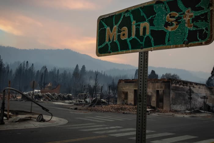
California’s Caldor Fire has grown 20 times bigger: ‘It’s devastation’
Doyle Rice, USA TODAY
California’s Caldor Fire was more than 20 times bigger on Thursday than it was on Tuesday and has forced over 10,000 people to flee their homes, according to fire officials.
On Wednesday, dozens of fire engines and crews were called in from other fires to fight the Caldor fire, which exploded through heavy timber in steep terrain since erupting over the weekend southwest of Lake Tahoe in El Dorado County.
The fire, the cause of which is unknown, was 0% contained as of Thursday, Cal Fire said. It’s now at over 65,000 acres in size.
Increased humidity on Wednesday night into Thursday morning helped slow the fire’s progress, but fire officials expect fire behavior to increase Thursday afternoon when the inversion layer lifts, sparking new spot fires to the north and northeast of the fire area. A red flag warning is scheduled to continue through 11 a.m. Thursday.
More than 6,900 structures are threatened by the fire.
The number of those evacuated in El Dorado County jumped to 16,380 Wednesday, up from about 6,850 the day prior, the Governor’s Office of Emergency Services told CNN.
The fire has blackened nearly 220 square miles and on Tuesday ravaged Grizzly Flats, California, a small community of about 1,200 people.
Dozens of homes burned there. Grizzly Flats resident Chris Sheean said the dream home he bought six weeks ago went up in smoke. “It’s devastation. You know, there’s really no way to explain the feeling, the loss,” Sheean said. “Everything that we owned, everything that we’ve built is gone.”
A home burns on Jeters Road as the Dixie fire jumps Highway 395 south of Janesville, Calif., on Monday, Aug. 16, 2021. Critical fire weather throughout the region threatens to spread multiple wildfires burning in Northern California.
Cal Fire reported Wednesday that the blaze had “experienced unprecedented fire behavior and growth due to extremely dry fuels pushed by southwest winds.”
Fire agencies battling the blaze say that the extent of the damage is not yet entirely known as unsafe conditions continue to prevent structure assessment teams from entering the area.
At least 16,000 other homes remain threatened by California wildfires, which are among some 104 burning throughout mostly Western states, officials from the National Interagency Fire Center said Thursday.
California’s wildfires are on pace to exceed the amount of land burned last year – the most in modern history.
The massive Dixie Fire – the nation’s largest at more than 1,000 square miles, which is about two-thirds the size of Rhode Island – also continued to burn Thursday.
The fire has destroyed 1,217 structures, including 649 homes, according to Cal Fire.
The Dixie Fire is the first to have burned from east to west across the spine of California, where the Sierra Nevada and Cascade mountains meet.
No deaths have been reported despite the speed and damage of the blazes in California.
Contributing: The Associated Press; The Record, Stockton, Calif.; The Reno Gazette-Journal
Southern California officials declare water supply alert
In this Monday, April 13, 2015, file photo, members of the board committee of the Metropolitan Water District, MWD moved forwards on a proposal that would cut regional water deliveries by 15 percent beginning this summer, during a meeting in Los Angeles. A major Southern California water agency has declared a water supply alert for the first time in seven years, Tuesday, Aug. 17, 2021 and is asking residents to voluntarily conserve. (AP Photo/Damian Dovarganes)
In this Aug. 13, 2021, file photo, a person looks out over Lake Mead near Hoover Dam at the Lake Mead National Recreation Area in Arizona. A major Southern California water agency has declared a water supply alert for the first time in seven years, Tuesday, Aug. 17, 2021 and is asking residents to voluntarily conserve. (AP Photo/John Locher, File)
This March 26, 2019 photo shows the water level of the Colorado River, as seen from the Hoover Dam, Ariz. A major Southern California water agency has declared a water supply alert for the first time in seven years, Tuesday, Aug. 17, 2021 and is asking residents to voluntarily conserve. (AP Photo/Richard Vogel, File)
In this Aug. 14, 2021, file photo, houseboats rest in a channel at Lake Oroville State Recreation Area in Butte County, Calif. At the time of this photo, the reservoir was at 24 percent of capacity and 34 percent of its historical average. A major Southern California water agency has declared a water supply alert for the first time in seven years, Tuesday, Aug. 17, and is asking residents to voluntarily conserve. (AP Photo/Noah Berger, File)
In this Wednesday, Aug. 4, 2021, file photo, signs alert visitors to the severe drought in Mendocino, Calif. A major Southern California water agency has declared a water supply alert for the first time in seven years, Tuesday, Aug. 17, and is asking residents to voluntarily conserve. (AP Photo/Haven Daley, File)
In this Feb. 28, 2014, file photo, Santa Monica, Calif., resident Josephine Miller stands next to her 200-gallon water storage tank that collects rain from her home’s roof to water her garden. A major Southern California water agency has declared a water supply alert for the first time in seven years, Tuesday, Aug. 17, 2021 and is asking residents to voluntarily conserve. (AP Photo/Reed Saxon, File)
FILE – In this May 23, 2021, file photo, a home destroyed in the 2020 North Complex Fire sits above Lake Oroville, in Oroville, Calif. California officials say the drought gripping the U.S. West is so severe it could cause one of the state’s most important reservoirs to reach historic lows by late August, closing most boat ramps and shutting down a hydroelectric power plant during the peak demand of the hottest part of the summer. (AP Photo/Noah Berger, File)
In this May 22, 2021, file photo, water drips from a faucet near boat docks sitting on dry land at the Browns Ravine Cove area of drought-stricken Folsom Lake, in Folsom, Calif. The Metropolitan Water District of Southern California declared a water supply alert for the first time in seven years and is asking residents to voluntarily conserve Tuesday, Aug. 17, 2021, hoping to lessen the need for more severe actions such as reducing water supplies to member agencies. The Metropolitan Water District of Southern California receives about half its water from the Colorado River and State Water Project. (AP Photo/Josh Edelson, File)
LOS ANGELES (AP) — A major Southern California water agency has declared a water supply alert for the first time in seven years and is asking residents to voluntarily conserve.
The Los Angeles Times reports that the board of the Metropolitan Water District of Southern California took the step Tuesday, hoping to lessen the need for more severe actions such as reducing water supplies to member agencies.
The move comes a day after U.S. officials declared the first-ever water shortage on the Colorado River, a key water source for Southern California.
“This is a wake-up call for what lies ahead,” said Deven Upadhyay, chief operating officer for the district that supplies water to 19 million Californians.
“We cannot overstate the seriousness of this drought,” he said. “Conditions are getting worse, and more importantly, we don’t know how long it will last.”
California Gov. Gavin Newsom last month asked Californians to scale back water use and many of the state’s counties, mostly in Central and Northern California, are already under a state of drought emergency.
Concern about water supplies spread to the state’s heavily-populated southern region following a winter of low precipitation and shrinking reservoirs throughout the West.
Newsom on Tuesday said he may put mandatory water restrictions in place in the coming months, the East Bay Times reported.
“At the moment, we’re doing voluntary,” he said. “But if we enter into another year of drought — and as you know our water season starts Oct. 1 — we will have likely more to say by the end of September as we enter potentially the third year of this current drought.”
The Metropolitan Water District of Southern California receives about half its water from the Colorado River and State Water Project.
Water levels in Lake Mead, the largest reservoir on the Colorado River, were at about 35% of capacity on Tuesday. The State Water Project, which collects water from rivers and tributaries, has already reduced the Southern California district’s allocation to 5% and next year the amount could be zero, officials said.
Scientists say climate change has made the American West much warmer and drier in the past 30 years and will keep making weather more extreme.
Glen MacDonald, a University of California, Los Angeles distinguished professor of California and the American West, said even if precipitation returned it would not likely be enough to keep pace with the loss of water through evaporation due to rising temperatures.
That has the potential to not only turn California lawns brown but could also affect the nation’s food supply, which relies heavily on the state’s farmlands, MacDonald said.
“We are living in the perfect drought, right now,” he said. “It’s unfortunate, but we kind of have seen this coming.”
Raging wildfires linked to thousands of COVID-19 cases and hundreds of deaths in 2020, study says
Adrianna Rodriguez, USA TODAY
The record-setting 2020 wildfire season scorched millions of acres, forcing the evacuation of hundreds of thousands of people and costing billions of dollars in insured losses.
Researchers at Harvard T.H. Chan School of Public Health used a statistical model to measure the connection between high levels of fine particulate air pollution, or PM2.5, produced by the wildfires and the number of COVID-19 cases and deaths in 92 counties.
They found a daily increase of 10 micrograms in PM2.5 per cubic meter of air for 28 days was associated with an 11.7% increase in COVID-19 cases and an 8.4% increase in death. Across the three states studied, researchers determined nearly 19,700 COVID-19 cases and 750 deaths were attributable to daily increases in PM2.5 from wildfires.
“The year 2020 brought unimaginable challenges in public health, with the convergence of the COVID-19 pandemic and wildfires across the western United States,” said senior author Francesca Dominici, professor of biostatistics, population and data science at Harvard Chan School. “Climate change – which increases the frequency and the intensity of wildfires – and the pandemic are a disastrous combination.”
COVID-19 cases had the biggest increase in Sonoma County, California, and Whitman County, Washington – 65.3% and 71.6%, respectively – sites of the Glass Fire and Babb-Malden Fire.
“That small particle is small enough to burrow into the lung in a way that sets it up for any respiratory disease,” said Dr. Len Horovitz, a pulmonary specialist at Lenox Hill Hospital in New York City. “It can burrow past the epithelium and create inflammation. It’s a setting for any respiratory disease, including COVID, to exacerbate.”
Wildfire smoke can temporarily compromise the immune system, said Dr. Kari Nadeau, director of the Sean N. Parker Center for Allergy and Asthma at Stanford University.
“When you breathe in smoke, those particulates get into the lungs … they can get into your bloodstream, and they damage your immune system,” she said. “COVID affects your immune system, your lungs and your blood vessels. So you’re getting doubled up targeting of these organs in a very pathological way. It’s like a double hit.”
Although the damage is typically reversible, Nadeau said, it can become permanent in residents who have lived for decades where wildfires are common and have been repeatedly exposed to high levels of PM2.5.
This year’s fire season is on pace to race past 2020. As of Aug. 12, 6,272 fires in California have burned about 1,432 square miles, according to Cal Fire.
Health experts worry the wildfires may lead to another rise in coronavirus cases this year. Unvaccinated Americans make up more than 90% of COVID-19 hospitalizations, and if the body’s defenses are further weakened by smoke, they stand little chance against the highly contagious delta variant.
They urge Americans to not only protect themselves from COVID-19 but also from wildfire smoke by staying indoors and wearing N95 masks that help block PM2.5.
“We need to try to prevent the wildfires, and we need to prevent COVID, and luckily, we have that knowledge in our hands,” Nadeau said. “We just have to do something actionable about it.”
Contributing: David Benda and Mike Chapman, Redding Record Searchlight
Health and patient safety coverage at USA TODAY is made possible in part by a grant from the Masimo Foundation for Ethics, Innovation and Competition in Healthcare. The Masimo Foundation does not provide editorial input.
Insurance companies are bailing in risk areas—what to do if your homeowners policy isn’t renewed
By Ben Moore August 16, 2021
Nonrenewals are on the rise—but there are alternatives
In July, fire swept through Greenville, Calif., destroying homes, historic buildings and forcing hundreds to evacuate. Getty Images
Homeowners insurance non-renewals are on the rise as private insurers steer clear of locations at high risk for natural disasters. The West Coast’s blazing wildfires are leaving some Californians scrambling to find coverage, while many Floridians are facing non-renewals during hurricane season.
In the midst of changing climate conditions and increasing weather-related catastrophes, it’s more crucial than ever to have insurance coverage for your home to have peace of mind. Here’s what to do if your homeowners insurance policy isn’t renewed.
1. Know your rights
An insurance company is usually required to provide a nonrenewal notice, typically at least 30 days prior to the end of coverage, unless you’ve missed a payment or committed fraud on your application. But you might get more time to find a new policy. For example, Florida homeowners could get up to 120 days’ notice, according to Stacey Giulianti, chief legal officer for Florida Peninsula Insurance Company.
If you believe you were wrongly dropped, you can contest the nonrenewal. You’ll likely need to prove that your home isn’t in a high-risk area, or that you’ve made efforts to mitigate that risk, like replacing the roof or removing flammable shrubs near your house.
2. Make home improvements
If your policy isn’t renewed because of a failed inspection, making the proper updates could help you maintain coverage, even if you’re in a high-risk area.
Inspections give homeowners the opportunity to fix problems, like leaky roofs or exposed electrical wiring, so they can keep an insurance policy, according to Michael Peltier, media relations manager for Citizens Property Insurance.
When making improvements, consider upgrading your home’s building materials. Newer materials may withstand weather catastrophes better than older ones while simultaneously lowering your insurance costs, Giulianti says. “The houses that are a hundred years old … aren’t going to withstand storms the same way as a brand-new concrete building.”
Building upgrades could include:
Replacing walls with ignition-resistant materials like stucco or fiber-cement siding to mitigate fire damage.
Switching to impact-resistant shingles to prevent roof damage.
Installing hurricane-resistant windows if you live on the coast.
3. Shop around for another policy
Your previous insurer may not be an option, but you should still shop around. “There’s almost always another company … that will pick you up,” Giulianti says.
An independent insurance agent can research home insurance quotes for companies in your area. You can also ask your real-estate agent, mortgage lender, home builder or previous owner for a list of companies, or call your state’s insurance department.
4. Turn to your state’s shared market option
If you still can’t find coverage, you may need a state-run shared market policy. Many states offer Fair Access to Insurance Requirements policies for high-risk homes, or beach and windstorm plans for coastal properties. Aptly named “last-resort” policies, FAIR policies offer limited coverage and are often more expensive than a standard home policy from a private insurer.
California’s FAIR Plan
The California FAIR Plan sells insurance for damage from fire, lightning, internal explosions and smoke, with optional coverage available at an additional cost. As wildfires worsen in the state, more customers are turning to the FAIR Plan for coverage, and this trend is expected to continue, Natalie Haskell, a spokesperson for the California FAIR Plan, wrote in an email.
But these policies don’t cover everything standard homeowners insurance policies do, like personal liability, your belongings or additional living expenses. For more extensive coverage, homeowners in California need to purchase a “difference in conditions” policy that complements FAIR Plan coverage to create a comprehensive home insurance policy.
Florida’s state-run insurer
Citizens Property Insurance, Florida’s insurer of last resort, has also seen an uptick in policy sales. But the reasons differ — worsening hurricane seasons combined with increasing litigation have driven up home insurance costs and non-renewals in the state.
Citizens offers coverage similar to that of private insurers, including dwelling, personal property, other structures and additional living expense coverage, though limits may be lower. In some areas, the company also sells wind-only policies that cover damage from hurricanes and other wind-related catastrophes. Policies are available only through an independent agent.
If you’ve exhausted all other options, surplus lines insurance may be available. Provided by specialized insurers that are regulated differently from standard companies, surplus lines offer coverage for risky properties when other insurers won’t. Available companies may vary by state, so speak with an insurance agent about surplus lines once you’ve been rejected by at least three other insurers.
Florida’s outdoor workers could lose billions as climate change makes it too hot to work
Alex Harris
Climate change, if left unchecked, could make outdoor work in notoriously hot Florida even more unbearable and unhealthy, and a new report shows it could also make that work less profitable.
Under scenarios where the world doesn’t quickly cut fossil fuel emissions, there could be a full month of the year where it’s too hot to safely work a normal day outside in Florida. Right now, Florida experiences an average of five days like that a year.
“Between now and mid-century, outdoor workers’ exposure to extreme heat would quadruple,” said Kristina Dahl, senior climate scientist at the Union of Concerned Scientists and co-author of the report. “That could put them in the position to increasingly choose between their health and their paychecks.”
Florida, the third-most populous state, has the third-largest population of outdoor workers. Those 2 million workers account for nearly a quarter of the state’s workforce and earn $56 billion a year.
Those earnings could be at risk in a future with more days where it’s too hot to work outside.
By the Union of Concerned Scientists’ calculations, Florida outdoor workers could lose up to $8.4 billion of those earnings by mid-century if no action is done to slow climate change. If the world acts slowly to lower fossil fuel emissions by that time, workers could lose less, around $6 billion.
The numbers grow more dire by century’s end. With continued slow action, workers could lose around $7.5 billion a year, versus double that amount with no action.
The only state with more potential earnings at risk is Texas.
As heat and humidity rise, the CDC recommends that employers provide more work breaks to avoid heat-related illness. However, reductions in work time would translate into losses in workdays (top map) and put workers’ earnings at risk (bottom). Florida, especially South Florida, ranks highly on both maps.
Per Florida worker, that breaks down to losing $3,743 a year in wages by mid-century if nothing is done to switch away from fossil fuels and $2,648 a year if slow action is taken.
Miami-Dade, Florida’s most populous county, has the most outdoor workers in the state — over 300,000.
Miami-Dade’s first Chief Heat Officer, Jane Gilbert, said she’s planning to host focus groups with outdoor workers and their employers to hear more about what conditions are like and how the county could possibly protect outdoor workers. So far, no one is talking about regulations for heat exposure for outdoor workers.
“Having something on the books that you cannot enforce doesn’t make sense,” she said. “I’d rather focus our resources on raising awareness, making employers aware of what their costs are and broader responsibilities to their workforce.”
She’s also talked with the National Weather Service about sending out more alerts for dealing with heat. This summer, cities from Seattle to Boston have issued heat advisories, but there have been none in Florida, despite record-breaking temperatures.
That’s because heat, like time, is relative.
The threshold for a heat advisory in Florida is a heat index (meaning temperature plus humidity, or “feels like”) of 108 degrees Fahrenheit for at least two hours. An “excessive” heat warning requires temperatures of 113 degrees.
“You can have pretty dangerous conditions over 100 heat index and they’re not even getting into advisories until 108,” she said.
Dr. Ankush Bansal, co-chair of the Florida Clinicians for Climate Action and a doctor of internal medicine in a Palm Beach County hospital, said extreme heat can take a toll on the body. It affects the lungs, the heart and especially the kidneys.
In extreme cases, heat illness can lead to red or brown urine, the result of muscles in the body breaking down into pieces and clogging up the kidneys.
“What happens is, and I’ve seen this, people that work outside … even athletes … are coming into the hospital with heat exhaustion or even heat stroke, which if untreated can lead to death,” he said. “If you have heart disease or a history of heart failure, it can throw you over the edge. It can cause a heart attack.”
The military treats extreme heat as a matter of national security. It has strict rules and a flag-based system for warning soldiers how much strenuous activity they can safely do outside in order to keep military personnel safe and healthy.
The Union of Concerned Scientists report calculated the potential lost wages by using similar standards, Centers for Disease Control and Prevention recommendations for worker safety on days when the heat index is at or over 100 degrees Fahrenheit. The center suggests workers take a break for 15 minutes every hour in shade and drink water.
As the heat index rises, the recommended amount of outdoor work drops. At 104 degrees Fahrenheit, the CDC says workers should work 30 minutes and rest 30 minutes. When the heat index crosses 108 degrees Fahrenheit (the standard for a heat advisory in Florida), the CDC recommends no one work outside at all.
The report assumed those breaks were unpaid.
“It’s an assumption but it also reflects to some extent that some outdoor workers are paid annually, some are paid hourly and others are paid piece rate,” Dahl said.
Tree trimmers work along Southwest 13th Street in Fort Lauderdale to remove limbs damaged during Hurricane Irma, Sept. 18, 2017.
Piece rate workers can be paid per pound of fruit or vegetable they pick, per lawn they mow or other per task goal, and would potentially have the most to lose economically in a future where it’s physically unsafe to work outside sometimes.
That’s a present reality in Saudi Arabia, where outdoor work is banned from noon to 3 p.m. from June to September to protect workers from dangerous heat.
In hot places like Arizona or Florida, outdoor workers already adjust their schedules to survive the summer. Construction workers get going at dawn and take breaks when the noonday sun is hottest. Some contractors, like AC repair workers, avoid sending employees into sweltering attics for jobs that can be put off til the cooler months.
Those adjustments may become more common in the U.S. as the world warms, but for now, they’re solely at the discretion of the employer.
There is no nationwide protective standard for outdoor workers, although the National Institute for Occupational Safety & Health developed standards in 2016 for the Occupational Safety and Health Administration to take up, which it never did. OSHA’s general duty clause requires employers to provide a safe working environment, and it has some recommendations for working in extreme heat, but it’s tough to enforce a recommendation.
Veronica Custodio, 37, picks through spinach at her father’s farm in Homestead on May 27, 2020. The farm belongs to Juventino Custodio, 53, who was forced to let his spinach rot after the coronavirus pandemic caused a disruption in his supply chain process.
A survey of hundreds of nursery workers in Homestead by the organization WeCount! found that more than half said they weren’t allowed to rest in the shade, 15% said they weren’t provided water and 69% had experienced symptoms of heat illness.
Farmworkers told the WeCount! organizers they try not to drink water so they can avoid bathroom breaks and possibly missing production quotas.
Another study of farmworkers in Central and South Florida measured core body temperatures, heat rate and hydration levels. Half started the day dehydrated, and three-quarters finished that way. One in three of the workers had acute kidney injury at some point in the study.
So far, California and Washington have passed state-level heat protection laws for outdoor workers, but they have different standards, leading to unequal protections during this summer’s heat wave.
“If we leave it up to states to do individually, we’re going to end up with a real patchwork of protections for outdoor workers,” Dahl said.
Reducing workload and shifting outdoor work to cooler parts of the day can help, she said. “But since there are limits to those, we found our first line of defense has to be reducing emissions.”
If Florida and the rest of the world stop burning fossil fuels, the worst effects of climate change and extreme heat can be avoided.
Bansal said there’s a common analogy in the medical world when discussing treating symptoms versus cause that applies to climate change too. If a bathtub is overflowing and you’re only putting towels on the floor but never turning off the water, the problem will never be fixed.
“And that’s what we need to do, shut off the faucet,” he said.
Miami Herald intern Ariana Aspuru contributed to this story.
Parts of the US are getting dangerously hot. Yet Americans are moving the wrong way
David Sirota and Julia Rock
Photograph: Justin Lane/EPA
Science has provided America with a decent idea of which areas of our country will be most devastated by climate change, and which areas will be most insulated from the worst effects. Unfortunately, it seems that US population flows are going in the wrong direction – new census data shows a nation moving out of the safer areas and into some of the most dangerous places of all.
The Census Bureau’s new map of the last decade’s population trends shows big growth in the west and on the coasts – and declines in the inland east coast and Great Lakes region.
Now compare that map to ProPublica maps documenting the areas most at risk of extreme heat, wildfires and flooding, and you see the problem. While there has been some recent anecdotalevidence of pragmatic climate migration, overall the census data shows America’s population growth is shifting out of areas that may be the best refuges from the most extreme effects of climate change, and into many areas that are most at risk.
Put another way: if climate change were an enemy in a war, America is not fortifying our population in the safest places – the country’s population is moving into the areas most at risk of attack.
Some of the examples are genuinely mind-boggling. For instance, upstate New York is considered one of the country’s most insulated regions in the climate crisis – and yet almost all of upstate New York saw population either nearly flat or declining. At the same time, there were big population increases in and around the Texas Gulf coast, which is threatened by extreme heat and coastal flooding.
Similarly, Philadelphia is comparatively well situated in the climate crisis – but it saw only modest population growth of 5%. It was surpassed on the list of biggest cities by Phoenix, which saw an 11% population growth, despite that city facing some of the worst forms of extreme heat and drought in the entire country.
And then there is south Florida, which saw Miami clock in a 10% population increase despite the possibility that large swaths of the city could soon be underwater. Compare that to a place like Vermont, where the population growth was flat.
This isn’t to blame Americans for moving to climate-threatened regions – after all, population growth and decline is often driven by the quest for necessities such as affordable housing and jobs. But the census data illustrate a trend that has been exacerbated by public policy.
For instance, weak zoning and land-use laws have encouraged a population explosion in the fire-prone wildland-urban interface, areas near forests and other vegetation. Likewise, federal flood-insurance subsidies have encouraged continued construction in coastal areas threatened by flooding. And corporations have not yet been forced to disclose their climate risks to investors, which potentially allows them to make investment and location decisions without factoring in such vulnerabilities.
There are ways to change the policies – for instance there has been a push to change zoning laws in ways that discourage or prohibit construction in areas most prone to wildfires. In May, Joe Biden issued an executive order requiring federally funded infrastructure to take into account current and future flood risks during construction, and the Securities and Exchange Commission is preparing a rule to require climate risk disclosures from all public companies.
But, as the census data suggest, the Biden administration has a long way to go.
The Federal Emergency Management Agency (Fema), which runs the national flood insurance program, has longbeenunderfunded and mostly helps wealthy and white homeowners. Moreover, a recent Government Accountability Office report found that while Fema has good information about flood risk to homeowners, it has not acted on that information to encourage homeowners to buy flood insurance. The report called on Congress to update the mandatory purchase requirement for flood insurance.
Meanwhile, homeowners have struggled to access buyout funds for flood-prone properties, which crucially encourage people to move out of high-risk areas and reduce the costs of future cleanup after disasters. Some parts of California have considered using that Fema aid for buyouts in wildfire-prone areas.
This spring, Fema updated its methodology for pricing flood insurance to make it more equitable and adapt to climate change.
But, of course, many of the efforts to fix those policies – or at least force them to factor in climate risks – now face vociferous opposition from powerful Republicans in Washington.
They want to pretend that nothing must fundamentally change – even though we’re already seeing that everything is changing faster than ever.
David Sirota is a Guardian US columnist and an investigative journalist. He is an editor at large at Jacobin and the founder of the Daily Poster. He served as Bernie Sanders’ presidential campaign speechwriter
Julia Rock is a staff writer at the Daily Poster
This article was originally published in the Daily Poster, a grassroots-funded investigative news outlet
The Taliban now controls one of the world’s biggest lithium deposits
By Tim McDonnell, Climate reporter August 16, 2021
REUTERS/MOHAMMAD ISMAIL.
Illegal mining of lapis lazuli, a gem, is a major source of revenue for the Taliban.
When Taliban fighters entered Kabul on Aug. 15, they didn’t just seize control of the Afghan government. They also gained the ability to control access to huge deposits of minerals that are crucial to the global clean energy economy.
In 2010, an internal US Department of Defense memo called Afghanistan “the Saudi Arabia of lithium,” after American geologists discovered the vast extent of the country’s mineral wealth, valued at at least $1 trillion. The silvery metal is essential for electric vehicles and renewable energy batteries.
Ten years later, thanks to conflict, corruption, and bureaucratic dysfunction, those resources remain almost entirely untapped. And as the US looks to disentangle its clean energy supply chains from China, the world’s top lithium producer, to have Afghanistan’s minerals under Taliban control is a severe blow to American economic interests.
“The Taliban is now sitting on some of the most important strategic minerals in the world,” said Rod Schoonover, head of the ecological security program at the Center for Strategic Risks, a Washington think tank. “Whether they can/will utilize them will be an important question going forward.”
Minerals are a double-edged sword for Afghanistan
Global demand for lithium is projected to skyrocket 40-fold above 2020 levels by 2040, according to the International Energy Agency, along with rare earth elements, copper, cobalt, and other minerals in which Afghanistan is naturally rich. These minerals are concentrated in a small number of pockets around the globe, so the clean energy transition has the potential to yield a substantial payday for Afghanistan.
In the past, Afghan government officials have dangled the prospect of lucrative mining contracts in front of their US counterparts as an enticement to prolong the American military presence in the country. With the Taliban in charge, that option is likely off the table.
But Ashraf Ghani, the World Bank economist-turned-Afghan president, who fled the country the day of the Taliban takeover, saw the minerals as a potential “curse.” For one, most economists agree that mineral riches breed corruption and violence, particularly in developing countries, and that they often fail to yield many benefits for average citizens. At the same time, the Taliban have long illegally tapped the country’s minerals (especially lapis lazuli, a gem) as a source of up to $300 million in annual revenue for their insurgency.
What happens now that the Taliban is in control
The Taliban can’t simply flick a switch and dive into the global lithium trade, Schoonover said. Years of conflict have left the country’s physical infrastructure—roads, power plants, railways—in tatters. And at the moment Taliban militants are reportedly struggling even to maintain the provision of basic public services and utilities in the cities they have captured, let alone carry out economic policies that can attract international investors.
Competing factions within the Taliban would make it very difficult for any company to negotiate mining deals, and China is unlikely to extend to the group the scale of infrastructure loans that would be required to bring any sizable mining operations online, said Nick Crawford, a development economics researcher at the International Institute for Strategic Studies think tank. That’s especially true after Chinese investors got burned on a $3 billion copper mining project in Afghanistan, that started in 2007 and failed to produce anything, largely because of challenges related to the lack of infrastructure.
“As long as there are safer and more reliable sources elsewhere, full utilization of Afghan minerals is likely to remain slow,” Schoonover said. However, China and Russia are already retaining diplomatic ties with the Taliban, and will almost certainly do business with the new regime on its home turf.
One reason for China to do so, Crawford said, could be to offshore some of the localized environmental destruction that comes with rare earth and lithium mining. In that case, mining is likely to add to the range of other environmental hazards—including water scarcity, air pollution, and extreme weather disastersrelated to climate change—already faced by the Afghan people.
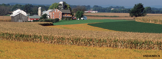
Cover crop usage sets record as farmers see environmental, financial benefits
Andy Knight, The Herald Bulletin, Anderson, Ind.
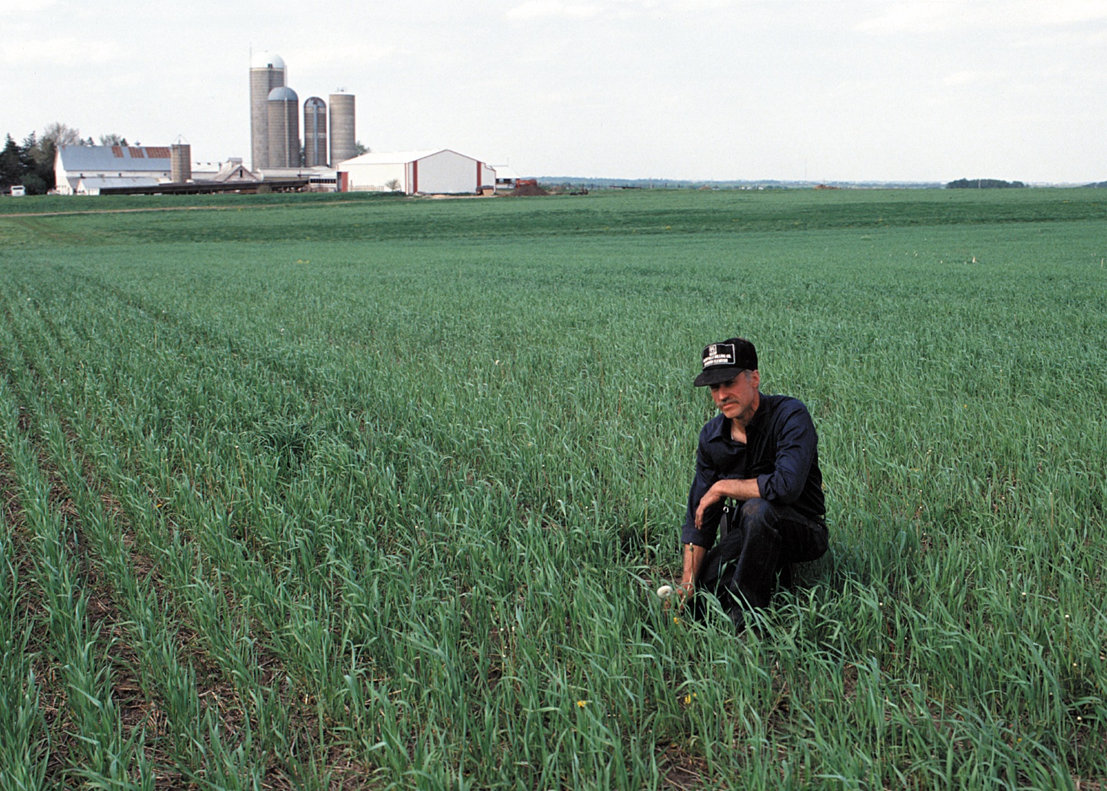
Aug. 14—FRANKTON — Most of the fields surrounding Mike Shuter’s farm in western Madison County had blossomed with corn and soybeans by early August.
But one, situated next to a winding driveway leading to the farmhouse, featured much smaller and less conspicuous greenery.
That 180-acre plot, Shuter said, is being used to grow buckwheat seed for use as a cover crop. Once fully grown — probably by early October — it will be harvested and replanted elsewhere to ensure that the microbes in the soil remain healthy, and that the soil itself will remain suitably porous throughout the winter months.
“It’s kind of an ongoing learning process,” said Shuter, the president of Shuter Sunset Farms, a fourth-generation family farm specializing in corn, beans, cattle and pork production. The operation covers about 3,000 acres in the northern and western parts of the county. “The more we understand about soil health and the microbes in the soil and how we’re helping them with cover crops, the deeper we get involved with it.”
Shuter and hundreds of other farmers across Indiana are integrating cover crops into their operations more than ever. According to a recent survey commissioned by the Indiana State Department of Agriculture, the state’s farmers set a record this year by planting an estimated 1.5 million acres of cover crops, also known as overwinter living covers.
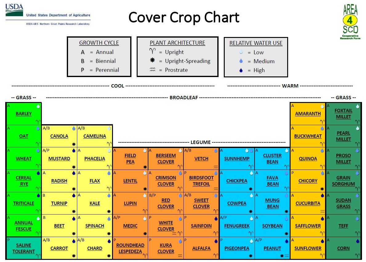
Cover crops are important, advocates say, because they promote a variety of environmental benefits. In addition to improving overall soil health by adding living roots to the soil over a greater time period each year, they also improve water filtration and increase organic matter in the soil. Some cover crops, such as legumes, also serve as natural fertilizers.
Shuter began experimenting with cover crops in 2009, and over the years he’s seen technology improve to a point where fine-tuning the ingredients in different herbicides is a more seamless process.
“Part of it was networking with other producers across Indiana and some other states and learning what their experiences have been,” he said. “We still try to network in and out, trying to help other producers understand what we’ve learned and still learning from some other good friends as well.”
By keeping roots in the ground throughout the winter, cover crops can also act as natural filters for ground water, which can prevent sediment from moving into nearby waterways, thus keeping the water supply cleaner.
“All those root channels help us capture those early spring rains,” said Jill Hoffmann, executive director of the White River Alliance, an Indianapolis-based nonprofit organization that promotes the improvement and protection of water resources in Central Indiana. “We’re also sequestering carbon, which helps us with climate change, and it helps the soil hold more water, so that can prevent loss during drought.”
The recent survey, conducted by the Indiana Conservation Partnership, estimated that 1.6 million tons of sediment was prevented from entering the state’s waterways. The practice of cover crop planting also kept approximately 4.1 million pounds of nitrogen and more than two million pounds of phosphorus out of lakes, rivers and streams, the study found.
“By increasing our cover crop practices, we are keeping Indiana waterways and soil healthier for future planting seasons and the next generation of farmers,” Lt. Gov. Suzanne Crouch said in a news release.
Shuter said he normally plants cereal rye ahead of soybeans and rye grass ahead of corn. He’s also taken part in crop study programs through the local Purdue Extension office, as well as other programs that have helped him refine his approach to using cover crops.
“We’ve had a few field days over the years where we talk about cover crops,” he said. “About 20% of our operation is organic now, and we’re using cover crops even more intensely in that. There’s a lot of things we’ve learned that we’ve been able to take advantage of in the years of experience we’ve got.”
In addition to environmental benefits including pollution prevention and carbon sequestration, conservationists say the practice also improves farmers’ bottom line.
“This year’s data may be surprising to some considering the tough farm economy this past year, but over time, our farmers have learned that incorporating a comprehensive management system into their operations that includes cover crops…helped improve the sustainability and productivity of their soils, said Indiana State conservationist Jerry Raynor. “As a result, farmers are sequestering more carbon, increasing water infiltration and improving wildlife and pollinator habitat — all while harvesting better profits and often better yields.”
Hoffmann said it’s encouraging to see many of the state’s farmers recognizing that they can play a role in preserving — and even bettering — the environment.
“As we look at the challenges that we’re facing environmentally, we all have our part to play,” she said. “To see farmers adopting these practices that not only benefit their operations, but also protect our water supply, it’s encouraging to me that they’re taking these actions.”
The Atlantic: The driving force behind ocean circulation and our taste for cod
Suzanne OConnell, Harold T. Stearns Professor of Earth Science, Wesleyan University and Pascal Le Floc’h, Maître de conférences, économiste, laboratoire Amure (UBO, Ifremer, CNRS), Université de Bretagne occidentale
Fishing boats coming into Le Guilvinec, Brittany, France, at the end of the day. Photoneye/Shutterstock
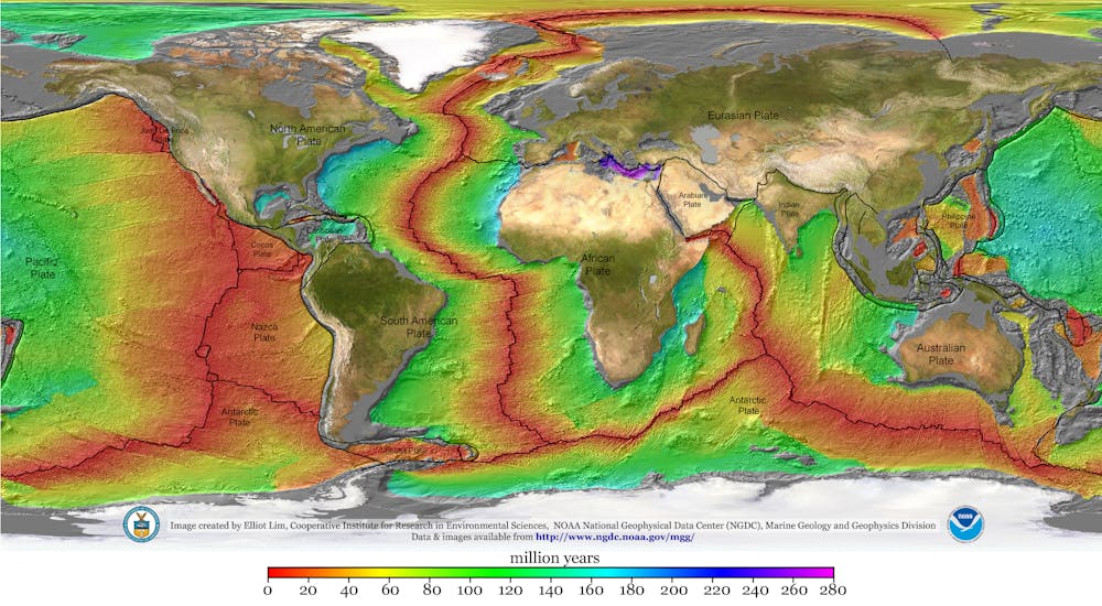
The answer? Yes, over millions of years. And it was the breakup of the supercontinent Pangea, starting some 180 million years ago, that began creating the Atlantic Ocean basin as we know it today.
Earth’s surface is made up of intersecting tectonic plates. For much of our planet’s history these plates have been bumping into one another, forming chains of mountains and volcanoes, and then rifting apart, creating oceans.
When Pangea existed it would have been possible to walk from modern Connecticut or Georgia in the U.S. to what is now Morocco in Africa. Geologists don’t know what causes continents to break up, but we know that when rifting occurs, continents thin and pull apart. Magma intrudes into the continental rocks.
The oldest portions of crust in the Atlantic Ocean lie off of North America and Africa, which were adjacent in Pangea. They show that these two continents separated about 180 million years ago, forming the North Atlantic Ocean basin. The rest of Africa and South America rifted apart about 40 million or 50 million years later, creating what is now the South Atlantic Ocean basin.
Magma wells upward from beneath the ocean floor at the Mid-Atlantic Ridge, creating new crust where the plates move apart. Some of this ocean crust is younger than you or me, and more is being created today. The Atlantic is still growing.
World map with colored zones showing age of ocean plates
Winds and currents
Once the ocean basin formed after Pangea’s breakup, water entered from rain and rivers. Winds began to move the surface water.
Thanks to the unequal heating of Earth’s surface and its rotation, these winds blow in different directions. The Earth is warmer at the equator than near the poles, which puts air in motion. At the equator the planet’s heat causes moist air to warm, expand and rise. At the polar regions cold, dry, heavier air descends.
This motion creates “cells” of rising and descending air that control global wind patterns. Earth’s rotation dictates that different parts of the globe travel at different speeds. At a pole, a molecule of air would just spin around, while a particle of air at the equator in Quito, Ecuador, would travel 7,918 miles (12,742 kilometers) in a single day.
This different movement causes the air cells to break up. For example, in the Hadley Cell, tropical air, which rose at the equator, cools in the upper atmosphere and descends at about 30 degrees north and south latitude – roughly, near the northern and southern tips of Africa. Earth’s rotation turns this descending air, creating trade winds that flow from east to west across the Atlantic and back to the equator. At higher latitudes in the North and South Atlantic, the same forces create mid-latitude cells with winds that blow from west to east.
Atmospheric circulation diagram
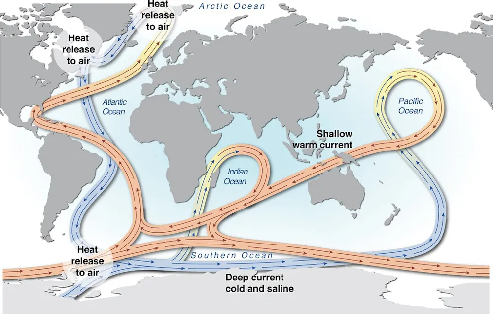
As air flows across the ocean’s surface, it moves water. This creates a circulating system of gyres, or rotating currents, that move clockwise in the North Atlantic and counterclockwise in the South Atlantic. These gyres are part of a global conveyor belt that transports and redistributes heat and nutrients throughout the global ocean.
The Gulf Stream, which follows the U.S. East Coast before heading east across the North Atlantic, is part of the North Atlantic gyre. Since the current carries warm water north, it is easy to see on false-color infrared satellite images as it transports heat northward. Like a river, it also meanders.
Moving water masses
These wind-blown surface currents are important for many reasons, including human navigation, but they affect only about 10% of the Atlantic’s volume. Most of the ocean operates in a different system, which is called thermohaline circulation because it is driven by heat (thermo) and salt (saline).
Like many processes in the ocean, salinity is tied to weather and circulation. For example, trade winds blow moist air from the Atlantic across Central America and into the Pacific Ocean, which concentrates salinity in the Atlantic waters left behind. As a result, the Atlantic is slightly saltier than the Pacific.
This extra salinity makes the Atlantic the driving force in ocean circulation. As currents move surface waters poleward, the water cools and becomes more dense. Eventually at high latitudes this cold, salty water sinks to the ocean floor. From there it flows along the bottom and back toward the the opposite pole, creating density-driven currents with names such as North Atlantic Deep Water and Antarctic Bottom Water.
Thermohaline circulation map
As these deep currents move, they collect surface organisms that have died and fallen to the bottom. With time, the organisms decompose, filling the deep water with essential nutrients.
In some locations this nutrient-rich water rises back up to the surface, a process called upwelling. When it reaches the ocean’s sunlit zone, within 650 feet (200 meters) of the surface, tiny organisms called phytoplankton feed on the nutrients. In turn, they become food for zooplankton and larger organisms higher up the food chain. Some of the the Atlantic’s richest fishing grounds, such as the Grand Banks to the southeast of Newfoundland in Canada and the Falkland/Malvinas Islands in the South Atlantic, are upwelling areas.
Much about the Atlantic remains to be discovered, especially in a changing climate. Will rising carbon dioxide levels and resulting ocean acidification disrupt marine food chains? How will a warmer ocean affect circulation and hurricane intensity? What we do know is that the Atlantic’s winds, currents and sea life are intricately connected, and disrupting them can have far-reaching effects.
Atlantic cod fishing
Now, let’s head back up to the surface, and into the wake of the first sailboats that set out to fish for cod along the Canadian coast. These pioneering ships paved the way for greater exploitation of the Atlantic’s wealth of fishery resources – particularly cod. Communities of people greatly benefited from these resources over the following centuries, until the threat of overfishing became impossible to ignore.
The history of fishing in the Atlantic is often said to trace back to the discovery of the cod-rich Canadian waters of Newfoundland, attributed to Italian navigator and explorer John Cabot, who led an English expedition there in 1497. From the 16th to the 20th centuries, cod-fishing mania swept European fleets. Between 1960 to 1976, ships from Spain, Portugal and France were responsible for 40% of the catch. However, in 1977 Canada extended its territory offshore by 200 miles, taking possession of the Newfoundland cod fisheries, which accounted for 70% of cod production in the Northwest Atlantic.
Fishermen aboard a boat with a haul of cod.
George Kristiansen/Shutterstock
For five centuries, the only thing that mattered was the size of the catch. This drove innovations in the design and equipment of fishing boats. The sailboat cod-fishing industry in Newfoundland and Iceland hit its peak in the late 19th century; from 1800 to 1900, France – the main fishing operator alongside Britain – outfitted more than 30,000 schooners.
At the end of the 19th century, the rowboat was replaced by the dory, a small (two-person) boat from North America, which sharply increased production. A plaque commenting on the new safety of the dory in the French Museum of Fisheries, in Normandy – dedicated to the history of commercial cod fishing – noted that the hazard of losing a man overboard was “built into the mindset of cod-fishing.” But by the early 20th century, steamers had begun to replace these boats.
New productivity gains came with new techniques, such as using back-trawling instead of side-trawling in the 1950s and 1960s, alongside reduced crew sizes.
The biggest cod catch, at nearly 1.9 million tons, was recorded in 1968. After that, overall production declined year after year, reaching less than a million tons in 1973. Numbers slowly picked up again in the 1980s after European fleets were excluded from the Newfoundland area, but this comeback was short-lived. On July 2, 1992, the Canadian government announced a moratorium on cod fishing, confirming that populations had collapsed. This collapse in the northwestern Atlantic has since become a textbook example of the risks of overfishing.
The wider catch
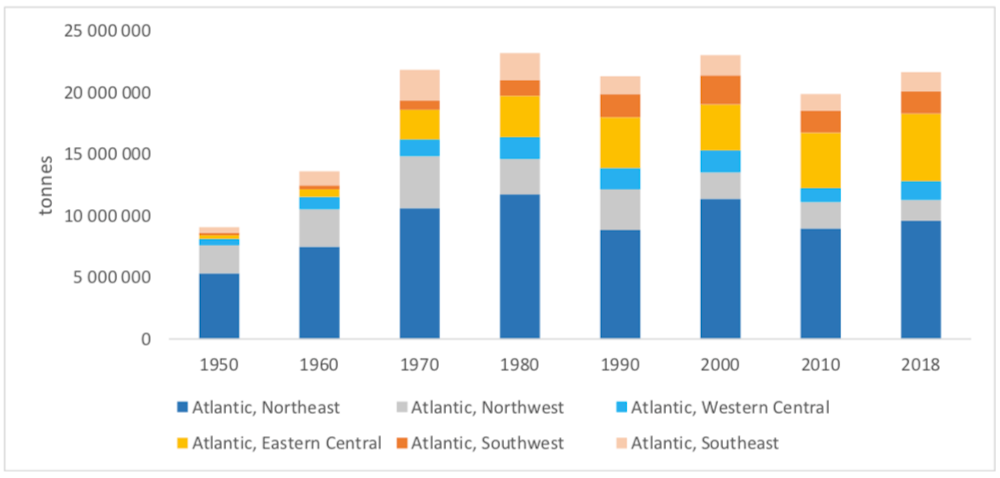
Seafood production in the Atlantic went from an estimated 9 million tons in 1950 to more than 23 million tons in 1980 and 2000, and 22 million tons in 2018. This overall production has remained stable since 1970.
In the North Atlantic, whiting and herring are the two most fished species by tonnage. Sardine and sardinella hold the top spots in the Central Atlantic. In the South Atlantic, mackerel and Argentine hake dominate the catch.
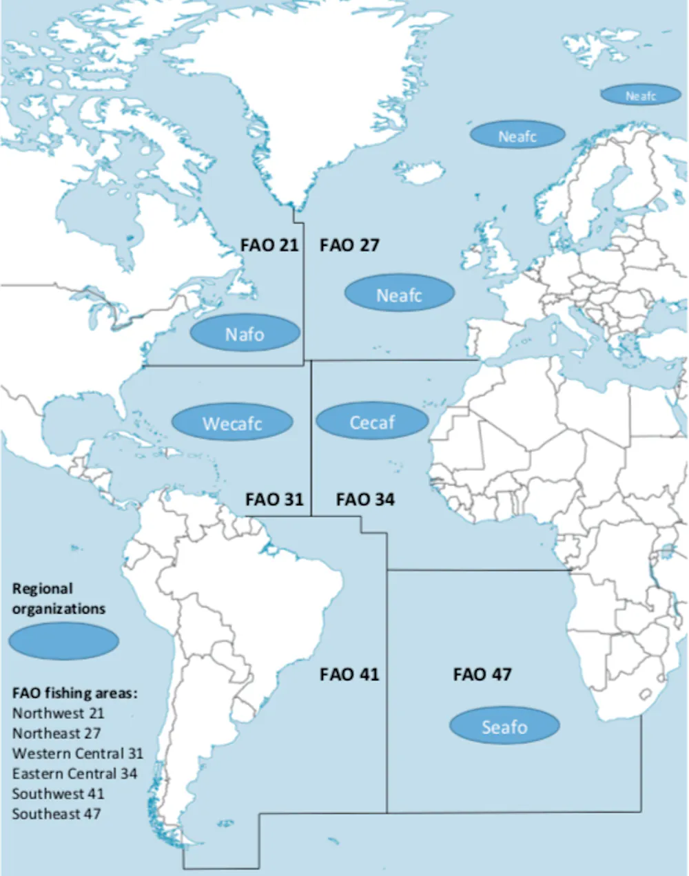
The Food and Agriculture Organization of the United Nations (FAO) has identified six production areas in the Atlantic Ocean, divided up cardinally, as shown on the map below. In 1950, these various areas accounted for 52% of the worldwide catch. From 1960 to 1980, this proportion went down to 37% to 43%. Since 1990, one-quarter of global seafood production is caught by fleets operating in the Atlantic.
Nearly 60% of seafood production now comes from fisheries in the Pacific Ocean, and 15% from the Indian Ocean.
The northeastern Atlantic (FAO Area 27) covers fisheries operated by European fleets. This area is, by far, the most bountiful of the entire Atlantic zone, with a total catch of 9.6 million tons in 2018.
Norway took the lead for seafood production by tonnage (2.5 million tons) in 2018, ahead of Spain (just under a million tons). It is also the most diversified zone, with more than 450 commercial species.
The northwestern Atlantic (FAO Area 21) stretches from the Rhode Island and Gulf of Maine coastlines in the U.S. to the Canadian coasts, including the Gulf of Saint Lawrence and the waters of Newfoundland and Labrador. Cod has dominated the history of fishing in this area since the 16th century. The biggest overall catch was recorded in 1970, at more than 4 million tons. But, after 1990, that number dropped, as a consequence of the 1992 moratorium. Since 2000, the northwest area has accounted for around 10% of the Atlantic catch (1.7 million tons in 2018). There are 220 monitored species in the area.
Eastern Central Atlantic (FAO Area 34) stretches from the Moroccan to the Zairian coasts. Species caught include sardine, anchovy and herring. In 2018, this area accounted for a quarter of the total seafood production of all six Atlantic areas. That same year, West African fisheries recorded the second biggest catches after the northeastern Atlantic. The high number of commercial species identified by the FAO sets this region apart, at nearly 300.
Western Central Atlantic (FAO Area 31) stretches from the southern U.S. to the north of Brazil, including the Caribbean. Since 1970, catch size has remained between 1.3 million and 1.8 million tons (5% to 10% of the entire Atlantic catch). Lobster and shrimp are the target species in the Caribbean waters.
Southeast Atlantic (FAO Area 47) connects the African coastlines of Angola, Namibia and South Africa. Production surpassed 2 million tons in 1970 and 1980, accounting for 10% of the total Atlantic catch. Since 1990, the catch has been stable, with a plateau of 1.5 million tons. It’s the least diversified region in the Atlantic, with 160 species monitored by the FAO. Mackerel, hake and anchovy make up 59% of total production.
Southwest Atlantic (FAO Area 41), which stretches along the coastlines of Brazil, Uruguay and Argentina in South America, was the lowest-producing of the six areas until 1980. It recorded no more than 5% of the total Atlantic catch. But from 1990, fisheries produced 1.8 million to 2 million tons (8% to 10% of the overall catch). This can be attributed to investment from the Argentinian government into fishing fleets in the 1980s. Some 225 commercial species are being statistically monitored, with 52% of total production coming from hake, shortfin squid and shrimp.
Protecting the entire ecosystem
At a time when scientific research predicts that all living marine resources will be exhausted by 2048, a new fisheries approach is required to avoid new tragedies, like the one that befell the cod populations in the northwestern Atlantic.
In this context, protecting ecosystems has become a priority. This growing acknowledgment of the impacts of fishing is a direct result of the successful work undertaken by ecological and social science researchers since the 1970s, who placed the concept of resilience at the heart of their studies.
This new ecosystem-based management approach, now inscribed in law in Europe and Canada, has been positive. A similar U.S. policy was revoked by President Donald Trump, but likely will be restored by incoming president Joe Biden. However, there is still work to do to tackle the main challenge – making this approach a reality in all Atlantic fisheries.
‘I can’t do it’: Portland residents battle grueling heat in unprecedented summer
Dani Anguiano in Portland
Photograph: Mathieu Lewis-Rolland/Reuters
“No, no, no,” Linda Longoria cried as she heard the weather forecast for Portland, Oregon on Friday: 100F (38C). “I can’t do it. Even in the shade it’s so humid.”
Longoria, 65, and her son are homeless and stay in hotels when they can but sometimes are forced to sleep outdoors. A lifelong resident of the city, she shook her head: “A heatwave in Portland. It’s not usually like this.”
Less than two months after seeing its highest temperature on record, 116F, the city of 645,000 was facing more grueling temperatures from yet another intense heatwave scorching the Pacific north-west.
People make use of Multnomah county’s Arbor Lodge cooling center on Thursday.Photograph: Dave Killen/AP
Temperatures in Portland climbed to 103F on Thursday while Bellingham, Washington, hit 100F for the first time. Seattle reached highs in the 90s. Much of the region was under an excessive heat warning through Saturday.
Portland typically sees mild summers with temperatures in the eighties in August. The heatwave, the second of the summer, is particularly dangerous in a region unaccustomed to such extreme heat. Ninety-six Oregon residents died in the June heatwave; 60 were Portland residents. The occurrence of that heatwave would have been virtually impossible without human-caused climate change, a detailed scientific analysis has found.
As the temperatures climbed in south-east Portland on Friday, streets were quieter than normal, save for a handful of cars and scattered cyclists. A haze of smoke from nearby wildfires covered the sky, which forecasters said could help keep temperatures on Friday and Saturday slightly lower than predicted. Some restaurants, food trucks and coffee shops closed early for the day, leaving notes of apology on their doors, citing the heatwave.
Meanwhile, the city closed its outdoor pools on Thursday and Friday afternoon to “protect all visitors and staff”.
Portland ranks third among the least air-conditioned US cities – about 70% of homes have air conditioning. Oregon’s governor, Kate Brown, and the Portland mayor, Ted Wheeler, declared a state of emergency earlier in the week due to the heat, and officials opened cooling centers across the city and state.
A county pool sits closed due to inclement weather, as a heatwave continues in Portland.Photograph: Mathieu Lewis-Rolland/Reuters
“Not everyone has a place to get cool. This climate doesn’t usually get this hot and it’s important people have a place to rest,” said Jake Dornblaser, who was overseeing a cooling center at a middle school in south-east Portland. “There are so many people in Portland that need access to resources.”
The center, which is open 24 hours a day through Sunday, provides people with food, water, beds and other basic items. Longoria had been sitting nearby in the heat with her son when a couple stopped to tell them about the center.
“I was so thankful. My son – he’s in a wheelchair with a broken leg. We were both hot sitting outside. We had never heard of this,” she said.
Crosby Lundbom and Destin Hornych make a water delivery during the heatwave in Portland.Photograph: Mathieu Lewis-Rolland/Reuters
The 65-year-old, who uses a walker, said she relied on water bottles and wet bandanas to survive the summer heat, but that this year had been particularly difficult. Longoria and her son lost their house in the city after her husband died.
“I’m gonna reminisce about my house and then walk in,” she said, looking at the cooling center.