US Veterans View Afghan Collapse With Anguish, Rage and Relief
Dave Philipps
Ginger Wallace, right, a retired Air Force colonel, with her wife, Janet Holliday, a retired Army colonel, in Louisville, Ky., on Monday, August 16, 2021. (Andrew Cenci/The New York Times)
On Javier Mackey’s second deployment to Afghanistan, one of his friends was shot in an ambush and bled to death in his arms. He saw high-ranking Afghan officers selling off equipment for personal gain and Afghan troops running away during firefights. And he started wondering what the United States could really achieve by sending thousands of troops to a distant land that seemed to have never known peace. That was in 2008.
Mackey, an Army Special Forces soldier, deployed there five more times, was shot twice, and, he said, grew more cynical on each trip, until he decided the only sensible thing for the U.S. to do was cut its losses and leave.
Even so, seeing the swift and chaotic collapse of the Afghan government in recent days hit him with the intensity of a bomb blast.
“It’s pain — pain I thought I had gotten used to,” said Mackey, who retired as a sergeant first class in 2018 and now lives in Florida. “I sacrificed a lot, I saw death every year. And the guys I served with, we knew it would probably come to an end like this. But to see it end in chaos, it makes us angry. After everything we gave, I just wish there had been a way to leave with honor.”
In the 20 years that the U.S. military was in Afghanistan, more than 775,000 U.S. troops deployed there, to citylike air bases and sandbag outposts on lonely mountaintops. As the Taliban swept into Kabul on Sunday, wiping away any gains made, veterans said in interviews that they watched with a roiling mix of sadness, rage and relief. Some were thankful that America’s involvement in the country seemed to have ended, but were also dismayed that hard-won progress was squandered. Others were fearful for Afghan friends left behind.
In interviews, text messages and on Facebook, men and women who collectively spent decades in Afghanistan said they were angry that despite a drawdown that has spanned years, the United States could not manage to exit the country with more dignity.
The anguish can be especially raw because veterans often worked side by side with Afghans during the years of attempts at nation-building, and now in that nation’s collapse they see the individual faces of friends who have been enveloped by the anarchy.
“My heart breaks for the Afghan people,” said Ginger Wallace, a retired Air Force colonel who in 2012 oversaw a program that retrained low-level Taliban fighters to clear land mines and work in other jobs that offered an alternative to combat.
At the time, she thought that efforts to stabilize Afghanistan were succeeding, and that U.S. troops would one day leave the country a better place. But her optimism slowly wore down as the Taliban gained ground.
“It’s heartbreaking, absolutely. I hate to see it end like this, but you don’t know what else we could have done,” she said from her home in Louisville, Kentucky. “Do we have an expectation that U.S. service members should stay and fight the Taliban when the Afghan army won’t?”
Wallace met her wife, Janet Holliday, while deployed in Afghanistan. The two normally watch the news each morning, but Monday, as scenes of mayhem unfolded at the airport in Kabul, Holliday, a retired Army colonel, switched to the Food Channel.
“It was too hard to watch,” Holliday said, excusing herself as she became upset. “I just can’t help thinking about what a waste it is. I can’t allow myself to think about how after all that blood and treasure, it ends like this.”
More than with other wars in the nation’s history, Americans have been mostly insulated from the fighting in Afghanistan. There was no draft or mass mobilization. Less than 1% of the nation served and a disproportionate number of troops came from rural counties in the South and West, far from the seats of power.
But veterans have said in interviews over the years that they were cleareyed about the challenges posed by the war, perhaps more so than the rest of the nation. They saw firsthand the deeply ingrained traditional cultures, tribal allegiances and endemic corruption that continually hobbled U.S. efforts.
Mackey agreed with President Joe Biden’s decision to withdraw, but thought the way it was done was slapdash and unprofessional.
“We train to have contingencies. The way it was handled was just irresponsible,” Mackey said. “We didn’t want to have another Vietnam, we wanted to do better.”
Jake Wood was a 25-year-old Marine sniper deployed to a forgotten corner of Afghanistan in 2008 when he started to see how much daylight there was between the optimistic pronouncements of top U.S. leaders and the reality of serving with Afghans on the ground.
Villagers in the district center of Sangin, where he manned an outpost, seemed to have little allegiance to the Afghan government in Kabul or the U.S. vision of democracy.
“We had no idea what our mission was, even back then,” said Wood, who now runs the nationwide veteran volunteering network Team Rubicon. “Were we trying to defeat the Taliban? Were we nation-building? I don’t think we knew.”
The Afghans he served with seemed to accept the uncertainty with a weary fatalism foreign to young Marines. At one point over small cups of tea, he said, he spoke with a young Afghan he served with who said Afghanistan only knows war, and when the U.S. war ended, another would come.
“He told me that maybe the Americans would come back,” Wood said. Then he recalled the Afghan saying, “But if you do, I can’t tell you if we’ll be friends or enemies.”
Wood said the veterans he has been in touch with feel a mix of sadness and fury watching the fall of Kabul: sadness that the folly that seemed so obvious in the ranks took years and thousands of lives for top leaders to accept; fury that the result of that ignorance and hubris was playing out on cable television in a way that would tarnish the reputation of the nation and the hundreds of thousands of troops who fought.
“We already knew we were losing the war,” he said. “But now we are losing it live on TV in front of the rest of the world. That’s what’s so hard.”
The Taliban now controls one of the world’s biggest lithium deposits
By Tim McDonnell, Climate reporter August 16, 2021
REUTERS/MOHAMMAD ISMAIL.
Illegal mining of lapis lazuli, a gem, is a major source of revenue for the Taliban.
When Taliban fighters entered Kabul on Aug. 15, they didn’t just seize control of the Afghan government. They also gained the ability to control access to huge deposits of minerals that are crucial to the global clean energy economy.
In 2010, an internal US Department of Defense memo called Afghanistan “the Saudi Arabia of lithium,” after American geologists discovered the vast extent of the country’s mineral wealth, valued at at least $1 trillion. The silvery metal is essential for electric vehicles and renewable energy batteries.
Ten years later, thanks to conflict, corruption, and bureaucratic dysfunction, those resources remain almost entirely untapped. And as the US looks to disentangle its clean energy supply chains from China, the world’s top lithium producer, to have Afghanistan’s minerals under Taliban control is a severe blow to American economic interests.
“The Taliban is now sitting on some of the most important strategic minerals in the world,” said Rod Schoonover, head of the ecological security program at the Center for Strategic Risks, a Washington think tank. “Whether they can/will utilize them will be an important question going forward.”
Minerals are a double-edged sword for Afghanistan
Global demand for lithium is projected to skyrocket 40-fold above 2020 levels by 2040, according to the International Energy Agency, along with rare earth elements, copper, cobalt, and other minerals in which Afghanistan is naturally rich. These minerals are concentrated in a small number of pockets around the globe, so the clean energy transition has the potential to yield a substantial payday for Afghanistan.
In the past, Afghan government officials have dangled the prospect of lucrative mining contracts in front of their US counterparts as an enticement to prolong the American military presence in the country. With the Taliban in charge, that option is likely off the table.
But Ashraf Ghani, the World Bank economist-turned-Afghan president, who fled the country the day of the Taliban takeover, saw the minerals as a potential “curse.” For one, most economists agree that mineral riches breed corruption and violence, particularly in developing countries, and that they often fail to yield many benefits for average citizens. At the same time, the Taliban have long illegally tapped the country’s minerals (especially lapis lazuli, a gem) as a source of up to $300 million in annual revenue for their insurgency.
What happens now that the Taliban is in control
The Taliban can’t simply flick a switch and dive into the global lithium trade, Schoonover said. Years of conflict have left the country’s physical infrastructure—roads, power plants, railways—in tatters. And at the moment Taliban militants are reportedly struggling even to maintain the provision of basic public services and utilities in the cities they have captured, let alone carry out economic policies that can attract international investors.
Competing factions within the Taliban would make it very difficult for any company to negotiate mining deals, and China is unlikely to extend to the group the scale of infrastructure loans that would be required to bring any sizable mining operations online, said Nick Crawford, a development economics researcher at the International Institute for Strategic Studies think tank. That’s especially true after Chinese investors got burned on a $3 billion copper mining project in Afghanistan, that started in 2007 and failed to produce anything, largely because of challenges related to the lack of infrastructure.
“As long as there are safer and more reliable sources elsewhere, full utilization of Afghan minerals is likely to remain slow,” Schoonover said. However, China and Russia are already retaining diplomatic ties with the Taliban, and will almost certainly do business with the new regime on its home turf.
One reason for China to do so, Crawford said, could be to offshore some of the localized environmental destruction that comes with rare earth and lithium mining. In that case, mining is likely to add to the range of other environmental hazards—including water scarcity, air pollution, and extreme weather disastersrelated to climate change—already faced by the Afghan people.
Cover crop usage sets record as farmers see environmental, financial benefits
Andy Knight, The Herald Bulletin, Anderson, Ind.
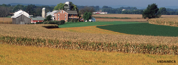
Aug. 14—FRANKTON — Most of the fields surrounding Mike Shuter’s farm in western Madison County had blossomed with corn and soybeans by early August.
But one, situated next to a winding driveway leading to the farmhouse, featured much smaller and less conspicuous greenery.
That 180-acre plot, Shuter said, is being used to grow buckwheat seed for use as a cover crop. Once fully grown — probably by early October — it will be harvested and replanted elsewhere to ensure that the microbes in the soil remain healthy, and that the soil itself will remain suitably porous throughout the winter months.
“It’s kind of an ongoing learning process,” said Shuter, the president of Shuter Sunset Farms, a fourth-generation family farm specializing in corn, beans, cattle and pork production. The operation covers about 3,000 acres in the northern and western parts of the county. “The more we understand about soil health and the microbes in the soil and how we’re helping them with cover crops, the deeper we get involved with it.”
Shuter and hundreds of other farmers across Indiana are integrating cover crops into their operations more than ever. According to a recent survey commissioned by the Indiana State Department of Agriculture, the state’s farmers set a record this year by planting an estimated 1.5 million acres of cover crops, also known as overwinter living covers.
Cover crops are important, advocates say, because they promote a variety of environmental benefits. In addition to improving overall soil health by adding living roots to the soil over a greater time period each year, they also improve water filtration and increase organic matter in the soil. Some cover crops, such as legumes, also serve as natural fertilizers.
Shuter began experimenting with cover crops in 2009, and over the years he’s seen technology improve to a point where fine-tuning the ingredients in different herbicides is a more seamless process.
“Part of it was networking with other producers across Indiana and some other states and learning what their experiences have been,” he said. “We still try to network in and out, trying to help other producers understand what we’ve learned and still learning from some other good friends as well.”
By keeping roots in the ground throughout the winter, cover crops can also act as natural filters for ground water, which can prevent sediment from moving into nearby waterways, thus keeping the water supply cleaner.
“All those root channels help us capture those early spring rains,” said Jill Hoffmann, executive director of the White River Alliance, an Indianapolis-based nonprofit organization that promotes the improvement and protection of water resources in Central Indiana. “We’re also sequestering carbon, which helps us with climate change, and it helps the soil hold more water, so that can prevent loss during drought.”
The recent survey, conducted by the Indiana Conservation Partnership, estimated that 1.6 million tons of sediment was prevented from entering the state’s waterways. The practice of cover crop planting also kept approximately 4.1 million pounds of nitrogen and more than two million pounds of phosphorus out of lakes, rivers and streams, the study found.
“By increasing our cover crop practices, we are keeping Indiana waterways and soil healthier for future planting seasons and the next generation of farmers,” Lt. Gov. Suzanne Crouch said in a news release.
Shuter said he normally plants cereal rye ahead of soybeans and rye grass ahead of corn. He’s also taken part in crop study programs through the local Purdue Extension office, as well as other programs that have helped him refine his approach to using cover crops.
“We’ve had a few field days over the years where we talk about cover crops,” he said. “About 20% of our operation is organic now, and we’re using cover crops even more intensely in that. There’s a lot of things we’ve learned that we’ve been able to take advantage of in the years of experience we’ve got.”
In addition to environmental benefits including pollution prevention and carbon sequestration, conservationists say the practice also improves farmers’ bottom line.
“This year’s data may be surprising to some considering the tough farm economy this past year, but over time, our farmers have learned that incorporating a comprehensive management system into their operations that includes cover crops…helped improve the sustainability and productivity of their soils, said Indiana State conservationist Jerry Raynor. “As a result, farmers are sequestering more carbon, increasing water infiltration and improving wildlife and pollinator habitat — all while harvesting better profits and often better yields.”
Hoffmann said it’s encouraging to see many of the state’s farmers recognizing that they can play a role in preserving — and even bettering — the environment.
“As we look at the challenges that we’re facing environmentally, we all have our part to play,” she said. “To see farmers adopting these practices that not only benefit their operations, but also protect our water supply, it’s encouraging to me that they’re taking these actions.”
The Atlantic: The driving force behind ocean circulation and our taste for cod
Suzanne OConnell, Harold T. Stearns Professor of Earth Science, Wesleyan University and Pascal Le Floc’h, Maître de conférences, économiste, laboratoire Amure (UBO, Ifremer, CNRS), Université de Bretagne occidentale
Fishing boats coming into Le Guilvinec, Brittany, France, at the end of the day. Photoneye/Shutterstock
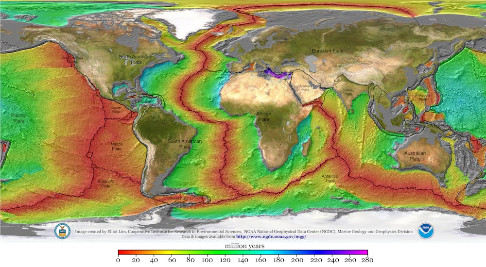
The answer? Yes, over millions of years. And it was the breakup of the supercontinent Pangea, starting some 180 million years ago, that began creating the Atlantic Ocean basin as we know it today.
Earth’s surface is made up of intersecting tectonic plates. For much of our planet’s history these plates have been bumping into one another, forming chains of mountains and volcanoes, and then rifting apart, creating oceans.
When Pangea existed it would have been possible to walk from modern Connecticut or Georgia in the U.S. to what is now Morocco in Africa. Geologists don’t know what causes continents to break up, but we know that when rifting occurs, continents thin and pull apart. Magma intrudes into the continental rocks.
The oldest portions of crust in the Atlantic Ocean lie off of North America and Africa, which were adjacent in Pangea. They show that these two continents separated about 180 million years ago, forming the North Atlantic Ocean basin. The rest of Africa and South America rifted apart about 40 million or 50 million years later, creating what is now the South Atlantic Ocean basin.
Magma wells upward from beneath the ocean floor at the Mid-Atlantic Ridge, creating new crust where the plates move apart. Some of this ocean crust is younger than you or me, and more is being created today. The Atlantic is still growing.
World map with colored zones showing age of ocean plates
Winds and currents
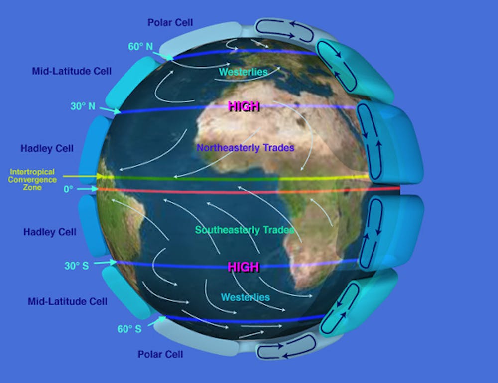
Once the ocean basin formed after Pangea’s breakup, water entered from rain and rivers. Winds began to move the surface water.
Thanks to the unequal heating of Earth’s surface and its rotation, these winds blow in different directions. The Earth is warmer at the equator than near the poles, which puts air in motion. At the equator the planet’s heat causes moist air to warm, expand and rise. At the polar regions cold, dry, heavier air descends.
This motion creates “cells” of rising and descending air that control global wind patterns. Earth’s rotation dictates that different parts of the globe travel at different speeds. At a pole, a molecule of air would just spin around, while a particle of air at the equator in Quito, Ecuador, would travel 7,918 miles (12,742 kilometers) in a single day.
This different movement causes the air cells to break up. For example, in the Hadley Cell, tropical air, which rose at the equator, cools in the upper atmosphere and descends at about 30 degrees north and south latitude – roughly, near the northern and southern tips of Africa. Earth’s rotation turns this descending air, creating trade winds that flow from east to west across the Atlantic and back to the equator. At higher latitudes in the North and South Atlantic, the same forces create mid-latitude cells with winds that blow from west to east.
Atmospheric circulation diagram
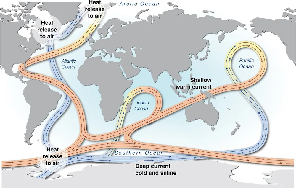
As air flows across the ocean’s surface, it moves water. This creates a circulating system of gyres, or rotating currents, that move clockwise in the North Atlantic and counterclockwise in the South Atlantic. These gyres are part of a global conveyor belt that transports and redistributes heat and nutrients throughout the global ocean.
The Gulf Stream, which follows the U.S. East Coast before heading east across the North Atlantic, is part of the North Atlantic gyre. Since the current carries warm water north, it is easy to see on false-color infrared satellite images as it transports heat northward. Like a river, it also meanders.
Moving water masses
These wind-blown surface currents are important for many reasons, including human navigation, but they affect only about 10% of the Atlantic’s volume. Most of the ocean operates in a different system, which is called thermohaline circulation because it is driven by heat (thermo) and salt (saline).
Like many processes in the ocean, salinity is tied to weather and circulation. For example, trade winds blow moist air from the Atlantic across Central America and into the Pacific Ocean, which concentrates salinity in the Atlantic waters left behind. As a result, the Atlantic is slightly saltier than the Pacific.
This extra salinity makes the Atlantic the driving force in ocean circulation. As currents move surface waters poleward, the water cools and becomes more dense. Eventually at high latitudes this cold, salty water sinks to the ocean floor. From there it flows along the bottom and back toward the the opposite pole, creating density-driven currents with names such as North Atlantic Deep Water and Antarctic Bottom Water.
Thermohaline circulation map
As these deep currents move, they collect surface organisms that have died and fallen to the bottom. With time, the organisms decompose, filling the deep water with essential nutrients.
In some locations this nutrient-rich water rises back up to the surface, a process called upwelling. When it reaches the ocean’s sunlit zone, within 650 feet (200 meters) of the surface, tiny organisms called phytoplankton feed on the nutrients. In turn, they become food for zooplankton and larger organisms higher up the food chain. Some of the the Atlantic’s richest fishing grounds, such as the Grand Banks to the southeast of Newfoundland in Canada and the Falkland/Malvinas Islands in the South Atlantic, are upwelling areas.
Much about the Atlantic remains to be discovered, especially in a changing climate. Will rising carbon dioxide levels and resulting ocean acidification disrupt marine food chains? How will a warmer ocean affect circulation and hurricane intensity? What we do know is that the Atlantic’s winds, currents and sea life are intricately connected, and disrupting them can have far-reaching effects.
Atlantic cod fishing
Now, let’s head back up to the surface, and into the wake of the first sailboats that set out to fish for cod along the Canadian coast. These pioneering ships paved the way for greater exploitation of the Atlantic’s wealth of fishery resources – particularly cod. Communities of people greatly benefited from these resources over the following centuries, until the threat of overfishing became impossible to ignore.
The history of fishing in the Atlantic is often said to trace back to the discovery of the cod-rich Canadian waters of Newfoundland, attributed to Italian navigator and explorer John Cabot, who led an English expedition there in 1497. From the 16th to the 20th centuries, cod-fishing mania swept European fleets. Between 1960 to 1976, ships from Spain, Portugal and France were responsible for 40% of the catch. However, in 1977 Canada extended its territory offshore by 200 miles, taking possession of the Newfoundland cod fisheries, which accounted for 70% of cod production in the Northwest Atlantic.
Fishermen aboard a boat with a haul of cod.
George Kristiansen/Shutterstock
For five centuries, the only thing that mattered was the size of the catch. This drove innovations in the design and equipment of fishing boats. The sailboat cod-fishing industry in Newfoundland and Iceland hit its peak in the late 19th century; from 1800 to 1900, France – the main fishing operator alongside Britain – outfitted more than 30,000 schooners.
At the end of the 19th century, the rowboat was replaced by the dory, a small (two-person) boat from North America, which sharply increased production. A plaque commenting on the new safety of the dory in the French Museum of Fisheries, in Normandy – dedicated to the history of commercial cod fishing – noted that the hazard of losing a man overboard was “built into the mindset of cod-fishing.” But by the early 20th century, steamers had begun to replace these boats.
New productivity gains came with new techniques, such as using back-trawling instead of side-trawling in the 1950s and 1960s, alongside reduced crew sizes.
The biggest cod catch, at nearly 1.9 million tons, was recorded in 1968. After that, overall production declined year after year, reaching less than a million tons in 1973. Numbers slowly picked up again in the 1980s after European fleets were excluded from the Newfoundland area, but this comeback was short-lived. On July 2, 1992, the Canadian government announced a moratorium on cod fishing, confirming that populations had collapsed. This collapse in the northwestern Atlantic has since become a textbook example of the risks of overfishing.
The wider catch
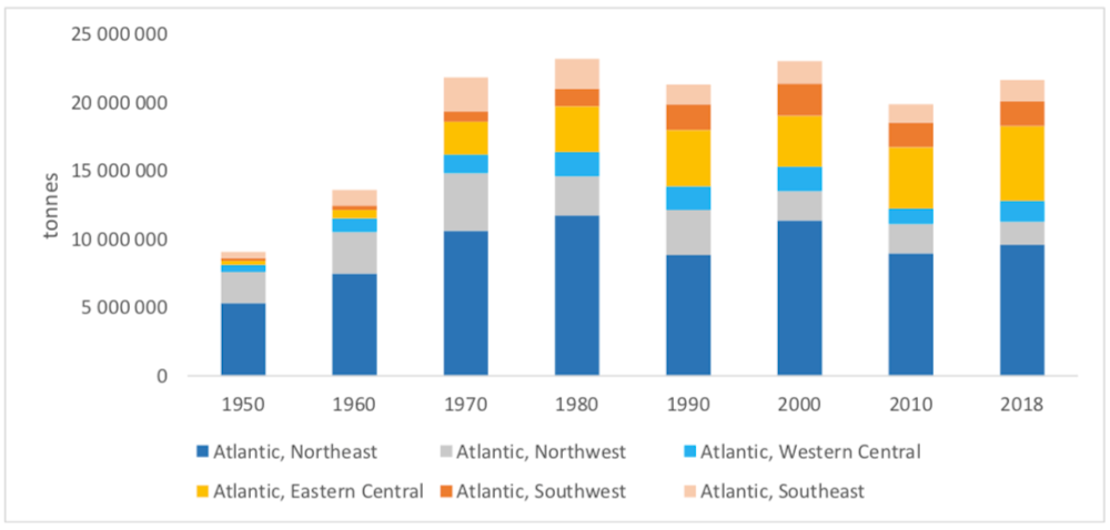
Seafood production in the Atlantic went from an estimated 9 million tons in 1950 to more than 23 million tons in 1980 and 2000, and 22 million tons in 2018. This overall production has remained stable since 1970.
In the North Atlantic, whiting and herring are the two most fished species by tonnage. Sardine and sardinella hold the top spots in the Central Atlantic. In the South Atlantic, mackerel and Argentine hake dominate the catch.
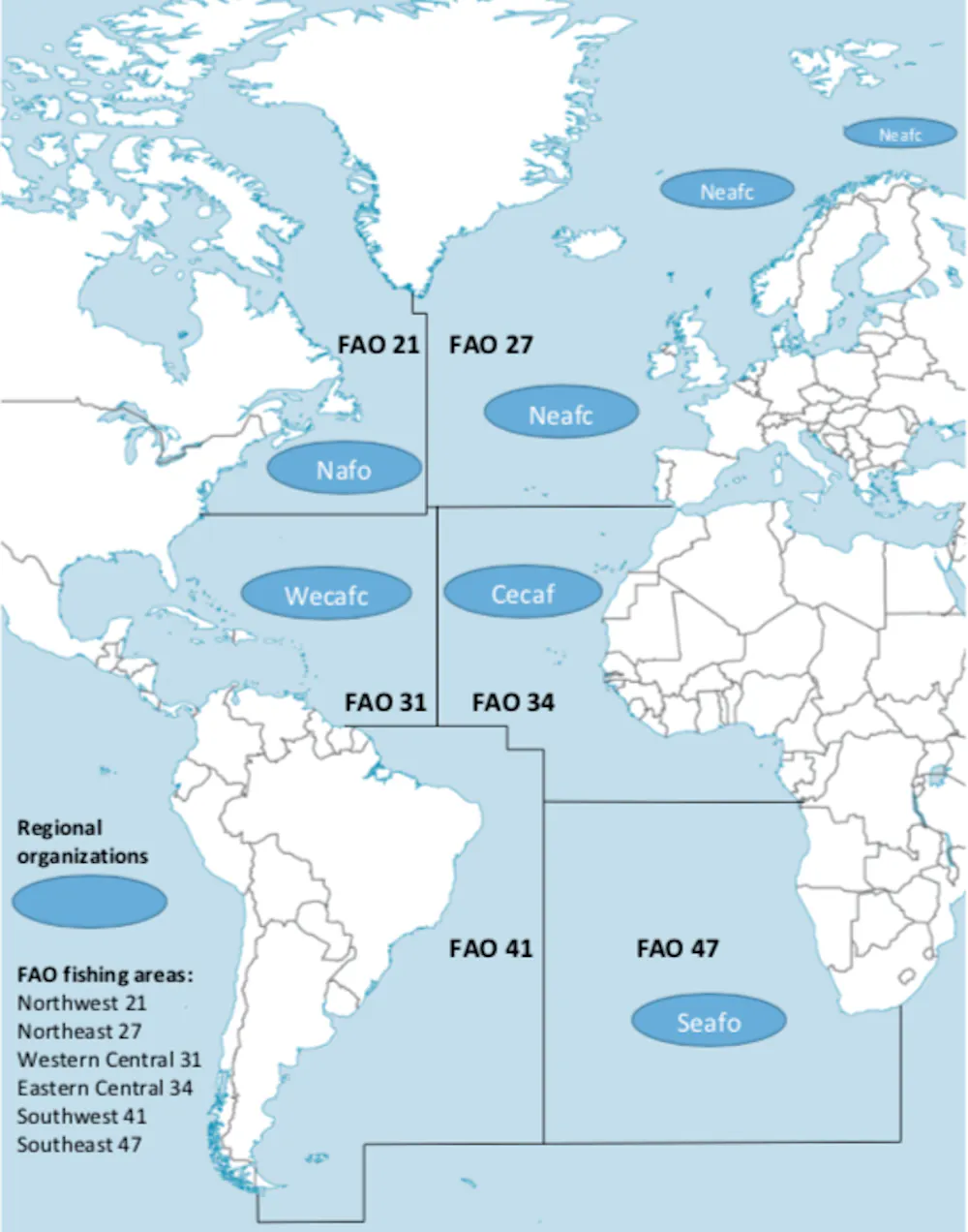
The Food and Agriculture Organization of the United Nations (FAO) has identified six production areas in the Atlantic Ocean, divided up cardinally, as shown on the map below. In 1950, these various areas accounted for 52% of the worldwide catch. From 1960 to 1980, this proportion went down to 37% to 43%. Since 1990, one-quarter of global seafood production is caught by fleets operating in the Atlantic.
Nearly 60% of seafood production now comes from fisheries in the Pacific Ocean, and 15% from the Indian Ocean.
The northeastern Atlantic (FAO Area 27) covers fisheries operated by European fleets. This area is, by far, the most bountiful of the entire Atlantic zone, with a total catch of 9.6 million tons in 2018.
Norway took the lead for seafood production by tonnage (2.5 million tons) in 2018, ahead of Spain (just under a million tons). It is also the most diversified zone, with more than 450 commercial species.
The northwestern Atlantic (FAO Area 21) stretches from the Rhode Island and Gulf of Maine coastlines in the U.S. to the Canadian coasts, including the Gulf of Saint Lawrence and the waters of Newfoundland and Labrador. Cod has dominated the history of fishing in this area since the 16th century. The biggest overall catch was recorded in 1970, at more than 4 million tons. But, after 1990, that number dropped, as a consequence of the 1992 moratorium. Since 2000, the northwest area has accounted for around 10% of the Atlantic catch (1.7 million tons in 2018). There are 220 monitored species in the area.
Eastern Central Atlantic (FAO Area 34) stretches from the Moroccan to the Zairian coasts. Species caught include sardine, anchovy and herring. In 2018, this area accounted for a quarter of the total seafood production of all six Atlantic areas. That same year, West African fisheries recorded the second biggest catches after the northeastern Atlantic. The high number of commercial species identified by the FAO sets this region apart, at nearly 300.
Western Central Atlantic (FAO Area 31) stretches from the southern U.S. to the north of Brazil, including the Caribbean. Since 1970, catch size has remained between 1.3 million and 1.8 million tons (5% to 10% of the entire Atlantic catch). Lobster and shrimp are the target species in the Caribbean waters.
Southeast Atlantic (FAO Area 47) connects the African coastlines of Angola, Namibia and South Africa. Production surpassed 2 million tons in 1970 and 1980, accounting for 10% of the total Atlantic catch. Since 1990, the catch has been stable, with a plateau of 1.5 million tons. It’s the least diversified region in the Atlantic, with 160 species monitored by the FAO. Mackerel, hake and anchovy make up 59% of total production.
Southwest Atlantic (FAO Area 41), which stretches along the coastlines of Brazil, Uruguay and Argentina in South America, was the lowest-producing of the six areas until 1980. It recorded no more than 5% of the total Atlantic catch. But from 1990, fisheries produced 1.8 million to 2 million tons (8% to 10% of the overall catch). This can be attributed to investment from the Argentinian government into fishing fleets in the 1980s. Some 225 commercial species are being statistically monitored, with 52% of total production coming from hake, shortfin squid and shrimp.
Protecting the entire ecosystem
At a time when scientific research predicts that all living marine resources will be exhausted by 2048, a new fisheries approach is required to avoid new tragedies, like the one that befell the cod populations in the northwestern Atlantic.
In this context, protecting ecosystems has become a priority. This growing acknowledgment of the impacts of fishing is a direct result of the successful work undertaken by ecological and social science researchers since the 1970s, who placed the concept of resilience at the heart of their studies.
This new ecosystem-based management approach, now inscribed in law in Europe and Canada, has been positive. A similar U.S. policy was revoked by President Donald Trump, but likely will be restored by incoming president Joe Biden. However, there is still work to do to tackle the main challenge – making this approach a reality in all Atlantic fisheries.
‘I can’t do it’: Portland residents battle grueling heat in unprecedented summer
Dani Anguiano in Portland
Photograph: Mathieu Lewis-Rolland/Reuters
“No, no, no,” Linda Longoria cried as she heard the weather forecast for Portland, Oregon on Friday: 100F (38C). “I can’t do it. Even in the shade it’s so humid.”
Longoria, 65, and her son are homeless and stay in hotels when they can but sometimes are forced to sleep outdoors. A lifelong resident of the city, she shook her head: “A heatwave in Portland. It’s not usually like this.”
Less than two months after seeing its highest temperature on record, 116F, the city of 645,000 was facing more grueling temperatures from yet another intense heatwave scorching the Pacific north-west.
People make use of Multnomah county’s Arbor Lodge cooling center on Thursday.Photograph: Dave Killen/AP
Temperatures in Portland climbed to 103F on Thursday while Bellingham, Washington, hit 100F for the first time. Seattle reached highs in the 90s. Much of the region was under an excessive heat warning through Saturday.
Portland typically sees mild summers with temperatures in the eighties in August. The heatwave, the second of the summer, is particularly dangerous in a region unaccustomed to such extreme heat. Ninety-six Oregon residents died in the June heatwave; 60 were Portland residents. The occurrence of that heatwave would have been virtually impossible without human-caused climate change, a detailed scientific analysis has found.
As the temperatures climbed in south-east Portland on Friday, streets were quieter than normal, save for a handful of cars and scattered cyclists. A haze of smoke from nearby wildfires covered the sky, which forecasters said could help keep temperatures on Friday and Saturday slightly lower than predicted. Some restaurants, food trucks and coffee shops closed early for the day, leaving notes of apology on their doors, citing the heatwave.
Meanwhile, the city closed its outdoor pools on Thursday and Friday afternoon to “protect all visitors and staff”.
Portland ranks third among the least air-conditioned US cities – about 70% of homes have air conditioning. Oregon’s governor, Kate Brown, and the Portland mayor, Ted Wheeler, declared a state of emergency earlier in the week due to the heat, and officials opened cooling centers across the city and state.
A county pool sits closed due to inclement weather, as a heatwave continues in Portland.Photograph: Mathieu Lewis-Rolland/Reuters
“Not everyone has a place to get cool. This climate doesn’t usually get this hot and it’s important people have a place to rest,” said Jake Dornblaser, who was overseeing a cooling center at a middle school in south-east Portland. “There are so many people in Portland that need access to resources.”
The center, which is open 24 hours a day through Sunday, provides people with food, water, beds and other basic items. Longoria had been sitting nearby in the heat with her son when a couple stopped to tell them about the center.
“I was so thankful. My son – he’s in a wheelchair with a broken leg. We were both hot sitting outside. We had never heard of this,” she said.
Crosby Lundbom and Destin Hornych make a water delivery during the heatwave in Portland.Photograph: Mathieu Lewis-Rolland/Reuters
The 65-year-old, who uses a walker, said she relied on water bottles and wet bandanas to survive the summer heat, but that this year had been particularly difficult. Longoria and her son lost their house in the city after her husband died.
“I’m gonna reminisce about my house and then walk in,” she said, looking at the cooling center.
Opinion: Where have all the climate change deniers gone?
Paul Thornton
An 8-year-old child looks at flames near his backyard in Monrovia as the Bobcat fire burns on Sept. 15, 2020. (Los Angeles Times)
In 2013, I unintentionally touched off a journalistic controversy when, in a short piece on counterfactual letters to the editor, I mentioned that denying the existence of evidence for climate change was an example of the kind of factual inaccuracies I try to keep off the page. A follow-up explaining my thinking as an editor on this drew more controversy. In many quarters at the time, climate change denial was considered a mainstream opinion occasionally worthy of print space.
Since the IPCC report was released Monday, our readers have expressed everything from despair to resolve to curb climate change. Letters denying the science still trickle in, but this isn’t anything like 2013.
To the editor: The Times’ Aug. 9 editorial on the U.N. climate report focuses on world leaders and their policies. But as one reader wrote in response to an earlier editorial on President Biden’s electric vehicle push, “Industrial policy is a fool’s errand…. Tastes, incomes and production costs determine what gets bought and sold.”
If that’s the case, then let’s change our tastes, incomes and production costs.
As consumers we can stop buying stuff we don’t need. As manufacturers we can choose not to be overcompensated. We can use the savings in executive salaries to ease production costs and boost the incomes of frontline workers, who could then afford to buy stuff they do need. We can embrace a simpler lifestyle that places less of a burden on the planet.
None of this requires government regulation or policy. What it requires is looking around and asking, whether it’s stuff or money, do I need all this?
Mary Bomba, Los Angeles
To the editor: Even as The Times’ pages fill with scientific warnings about how quickly we must act to avoid the worst of global warming, a Bloomberg article on your Business pages tells us that U.S. carbon emissions will surge this year. The economy is springing back and fossil fuel use is increasing.
The market prices of coal, oil and natural gas in no way reflect the catastrophic effects they are having on our planet. This is why “business as usual” cannot be allowed to continue. Putting a rapidly escalating tax on carbon is essential to rendering fossil fuels less and less attractive economically. That in turn will accelerate the adoption of alternatives.
New fossil fuel exploration should cease now. Clean-energy infrastructure must be placed on a war footing. Conservation, forestation and many other solutions clamor for implementation. And poor nations must be helped by rich ones.
It is high time for the world, led by the U.S., to accept we are all in the same boat that will founder unless we get serious.
Grace Bertalot, Anaheim
To the editor: I do not accept the idea that our response to climate change will fail as it has with the pandemic.
Reducing greenhouse gasses does not rely on micro-level decisions made by individuals. Rather, it depends on the macro policies put in place by government. Placing a substantial price on carbon at its source is the best way to significantly impact global temperatures.
For inspiration, we can look back on the 1980s. It was then that the world became aware of the enlarging hole in the atmosphere’s ozone layer, created by the use of chlorofluorocarbons (CFCs) in aerosol products, refrigeration and air conditioning.
Though initially skeptical about the need for government intervention, President Reagan listened to the science and, ultimately, signed onto the Montreal Protocol of 1987, a global treaty to phase out CFCs. Reagan realized that government needed to quickly address this emergency and, consequently, incentivize the production of CFC-free products.
Likewise, private citizens alone cannot solve climate change. Our environmental story will not echo our COVID-19 tragedy if government does what it is meant to do: Act in big ways to solve big problems.
Sarah Freifeld, Valencia
To the editor: Our beautiful and wondrous planet will undoubtedly regenerate itself and go on with or without humans. What is truly threatened or may need saving right now is humanity.
Perhaps natural selection is already playing out. When the human animal does nothing to protect its young by refusing vaccination, consumes products it does not need, flies in planes and goes on cruises and burns fossil fuels while the very life systems that support it are contaminated and altered by its activities, what else are we to conclude?
It would have been nice if humans could have heeded the wake-up call that was COVID-19. It is beyond sad that we are taking many non-human animals and plants down with us in the mass extinction crisis that is happening right now.
But there is hope. Nature bats last.
Gina Ortiz, Claremont
To the editor: In 1968, I went to a movie theater and watched a blockbuster science fiction movie. The shocking twist ending, that we had destroyed our planet, brought the character played by Charlton Heston to his knees in horror.
Today, my horror is that “Planet of the Apes” was not necessarily science fiction.
“The climate is f’d. Even worse than it seems.” That’s from the opening page of a 12-page letter sent by venture capitalist Chris Sacca to potential investors in Lowercarbon Capital, the climate-focused firm he launched last year after a brief retirement.
What’s new: Lowercarbon, which initially funded more than 50 startups via money from Sacca and his wife Crystal, last week announced that it raised $800 million in outside capital.
The $800 million is split among four funds, two early-stage and two later-stage. Each strategy includes a small fund that contains a slice of existing Lowercarbon portfolio companies, so that LP and GP interests are more aligned (plus, it was a marketing sweetener).
Why it matters: Both institutional and individual investors have gotten over ROI PTSD from the initial green-tech investing boom, with Sacca telling me that the funds were more than 2x oversubscribed in just a matter of days.
“Carbon is an expensive, inefficient thing,” Sacca argues. “Anywhere we can remove it from the process, it’s cheaper. That means customers. We’re not running a nonprofit here.”
“One big difference between now and years ago is that current tech makes it so much faster for startups to get to the binary point of understanding if something works or not. Biotech’s binary moment usually comes much later, and even web/app stuff can take a couple years to build something that you don’t actually know if it will catch on.”
Big picture: There is still a relative dearth of early-stage firms investing in green tech, despite an emerging consensus that climate change is an existential threat and that it can’t be stemmed (let alone reversed) via policy change alone.
Sacca believes we’ll know the money is matching the opportunity when we see more VC firms hire climate scientists like Lowercarbon’s Clea Kolster.
“I’m seeing more traditional VCs who do care and want to be proud of what they do. But we’re still not seeing too much competition, because most of these firms are clustering around lower-impact, consumer-facing technologies like basic reuse and recycling because they don’t yet have the skill set for deeper tech.”
Also: Lowercarbon had planned to offer some fund allocations to Historically Black Colleges and Universities on a no-fee/no-carry basis. But it hasn’t happened yet, as Sacca says it’s proven surprisingly difficult to find “decision-makers” at schools that haven’t traditionally had access to top VC funds.
“Our goal now is to donate a few million of each fund to HBCUs, while setting up direct relationships with the schools so they can get similar deals with other big VC funds. It’s kind of an open invitation because we have a chunk of these funds waiting for them. Maybe this interview will help get the word out.”
The bottom line: If we’re going to innovate our way out of global climate catastrophe, venture capital must play a key role. Right now.
Fish fewer at Hanauma Bay since reopening with new visitor limitations system
Mindy Pennybacker, The Honolulu Star-Adv.
Aug. 16—In the first light of day, at 7 a.m., when Hanauma Bay Nature Preserve opens to the public, its great half moon of beach is empty, and the sea over its dappled reef is at peak clarity, before rising winds and waves, kicking swim fins and wading feet bring turbidity.
It’s also the time when Hawaii residents with state IDs enjoy the privilege of entering the vast, collapsed volcanic crater without a reservation until 8 a.m.
“It’s impossible to get a reservation online—they’re all gone in one minute—so I drove here by 6 :30 a.m., ” said Annabella Taylor of Palolo Valley as she and her children, Zoe, Zen and Zarina, paused to overlook the bay’s turquoise waters as they walked down the hill Thursday morning.
Under a new reservation and visitor limitations system aiming to reduce stress on the bay’s coral reef ecosystem when it reopened in December, after 8-1 /2 months’ closure due to COVID-19, the preserve currently receives about 1, 400 visitors a day—half its former 3, 000 visitors a day but almost twice the 720-780 daily visitors initially allowed at reopening, according to Nathan Serota, spokesman for the Honolulu Department of Parks and Recreation.
Meanwhile, a new study has found that population density and biomass of more than half the bay’s most common fish species increased during the closure but decreased after reopening at only 25 % of the former visitor load.
This suggests “human avoidance behavior, even at 25 % capacity of visitors, for these more sensitive species, ” according to the “Hanauma Bay Biological Carrying Capacity Survey 20 /21 Annual Report, ” the third annual report conducted for DPR by the Coral Reef Ecology Lab of the Marine Biology Institute of the University of Hawaii at Manoa.
The study period ended two months after reopening and before the city began raising admission quotas. said lead author Sarah Severino.
“I find it interesting that seven of the 13 most abundant fish species in the bay showed an increase in density during closure, and after reopening really decreased in abundance, (showing ) some response to an increase in visitors, even at 25 % of normal visitor capacity prior to closure, ” Severino said in a telephone interview.
“A lot of the study is broken down by species, ” she noted, explaining that biomass refers to the size of the fish and the numbers of that particular fish, combined.
While many larger, common fish such as surgeonfish showed an increase both during the closure and after the reopening of the bay, the report said, many smaller species, such as butterflyfish, snappers and wrasses, decreased after the reopening.
“We’re thinking that these fishes are more sensitive to human interactions so may be modifying their behaviors, ” Severino said, adding what she meant by sensitivity was “when you’re snorkelling around and fish respond to you (being ) next to them and go into a hole, while other species don’t seem fazed at all.”
The seven species that increased with closure and decreased with reopening were palenose parrotfish (uhu ), saddle wrasse (hinalea lauwili ), belted wrasse (omaka ), brighteye damselfish, blackspot sergeant (kupipi ), white spotted toby and chubs (nenue ).
Diversity of fish species also changed, Severino said, most notably in Keyhole, the most heavily snorkeled area of the bay.
While Keyhole significantly increased in mean fish density and biomass throughout the closure, it also experienced significant decreases in the number of species of fish (species diversity ) and relative abundance of different species (species evenness ), “which means less species in Keyhole, ” she said.
Brown surgeonfish, convict tangs (manini ) and chubs “have now infiltrated and become dominant species in Keyhole, and smaller ones are either hiding or have moved elsewhere (in the bay ), ” Severino said, adding, “Generally speaking, higher diversity is associated with a healthier reef.”
At the same time, she pointed out, an increase in diversity was seen in the Channel sector of the bay, which has more reef with crevices and holes, compared with Keyhole’s open, sand-bottom spaces.
Density of butterflyfish increased during the closure within all sectors, suggesting they may have come in from offshore or ventured out of shelter due to lack of visitors, the report said.
The marine biology team also conducted video recordings of fish behavior and found “when more snorkelers were in the water, they would flee sooner when approached, and when there were less snorkelers, they would let you approach closer before they would flee, ” Severino said.
The bay’s water was 56 % clearer during closure when compared with days at full capacity in 2018, “which was pretty significant, ” Severino said, adding it remained 12.2 % clearer after reopening at 25 % capacity, “so that is something we can be excited about.”
There was 8.9 % greater clarity during the closure than on Tuesdays, when the bay was closed to public, in 2018.
Since reopening, the bay is closed Mondays as well as Tuesdays.
On Thursday morning a reporter who last swam in the bay on its first reopening day Dec. 3 observed fewer, and different, fish species in Keyhole than the last time.
There were still large surgeonfish and large schools of manini, but compared with before, there were few turquoise parrotfish and red-and-green wrasses and none of the dinner plate-size butterflyfish that had previously swum close to humans without flinching.
Here and there a couple of pairs of small, four-spot butterflyfish swam unhurriedly beneath a swimmer without fleeing, but two threadfin butterflyfish were already deep in a hole, looking up, as a lone human approached ; bird wrasses, with their long-nosed white faces, were prevalent before and now nowhere to be seen.
However, this was only what scientists call an anecdotal observation ; in contrast, Ron Sanderson of Hawaii Kai, who has swum in the bay almost weekly for 50 years, said he saw “hundreds and hundreds of fish, the usual kine, ” and was “so excited to be here because the online reservation system was impossible for me.”
While they hadn’t yet been in the water, first-time Hawaii visitors Zach Urgena, 28, and Mariel Cruz, 27, of New York City said they were astonished by the unique beauty of the bay and thought the $25 entry fee a person, recently raised from $12.50, was fair “because it’s to keep up the preserve, ” Urgena said.
The cost was minimal compared with the “hundreds of dollars a person we pay to go to Disneyland, ” said James Craig, a visitor from Pensacola, Fla.
Visitors also praised the video all entrants are required to view in the preserve’s theater before descending to the beach.
“The video was very informational, with the safety rules and what we can do to protect the reef, like not touching the animals or feeding them, and not leaving trash behind, ” said Lizbeth Yerena, 22, of Los Angeles.
She added she would apply the knowledge “to maintain our sea life no matter where.”
Despite having to make an early morning drive to enter without a reservation, “I agree, to preserve the reef, they need to limit visitors, ” said Waipahu resident Edie Ruiz, who arrived with her family at 5 :50 a.m., adding she felt tourists should be welcome “so long as they respect the aina.”
As for how many tourists—and residents—the bay can tolerate, “I think there’s a happy medium, something we’ve been trying to find throughout our three-year capacity study, ” Severino said.
EXPLAINER: Western states face first federal water cuts
Suman Naishadham
WASHINGTON (AP) — U.S. officials on Monday declared the first-ever water shortage from a river that serves 40 million people in the West, triggering cuts to some Arizona farmers next year amid a gripping drought.
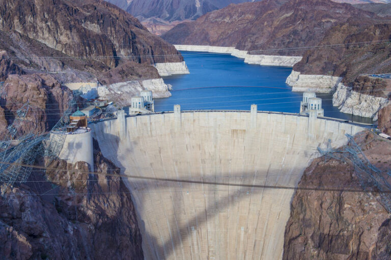
Water levels at the largest reservoir on the Colorado River — Lake Mead — have fallen to record lows. Along its perimeter, a white “bathtub ring” of minerals outlines where the high water line once stood, underscoring the acute water challenges for a region facing a growing population and a drought that is being worsened by hotter, drier weather brought on by climate change.
States, cities, farmers and others have diversified their water sources over the years, helping soften the blow of the upcoming cuts. But federal officials said Monday’s declaration makes clear that conditions have intensified faster than scientists predicted in 2019, when some states in the Colorado River basin agreed to give up shares of water to maintain levels at Lake Mead.
“The announcement today is a recognition that the hydrology that was planned for years ago — but we hoped we would never see — is here,” said Bureau of Reclamation Commissioner Camille Touton.
Lake Mead was formed by building the Hoover Dam in the 1930s. It is one of several man-made reservoirs that store water from the Colorado River, which supplies household water, irrigation for farms and hydropower to Arizona, California, Colorado, Nevada, New Mexico, Utah, Wyoming and parts of Mexico.
But water levels at Lake Mead and Lake Powell, the river’s two largest reservoirs, have been falling for years and faster than experts predicted. Scorching temperatures and less melting snow in the spring have reduced the amount of water flowing from the Rocky Mountains, where the river originates before it snakes 1,450 miles (2,334 kilometers) southwest and into the Gulf of California.
“We’re at a moment where we’re reckoning with how we continue to flourish with less water, and it’s very painful,” said Sarah Porter, director of the Kyl Center for Water Policy at Arizona State University.
HOW IS THE RIVER WATER SHARED?
Water stored in Lake Mead and Lake Powell is divvied up through legal agreements among the seven Colorado River basin states, the federal government, Mexico and others. The agreements determine how much water each gets, when cuts are triggered and the order in which the parties have to sacrifice some of their supply.
Under a 2019 drought contingency plan, Arizona, Nevada, California and Mexico agreed to give up shares of their water to maintain water levels at Lake Mead. The voluntary measures weren’t enough to prevent the shortage declaration.
WHO DOES LAKE MEAD SERVE?
Lake Mead supplies water to millions of people in Arizona, California, Nevada and Mexico.
Cuts for 2022 are triggered when predicted water levels fall below a certain threshold — 1,075 feet (328 meters) above sea level, or 40% capacity. Hydrologists predict that by January, the reservoir will drop to 1,066 feet (325 meters).
Further rounds of cuts are triggered when projected levels sink to 1,050, 1,045 and 1,025 feet (320, 318 and 312 meters).
Eventually, some city and industrial water users could be affected.
Lake Powell’s levels also are falling, threatening the roughly 5 billion kilowatt hours of electricity generated each year at the Glen Canyon Dam.
Colorado, New Mexico, Utah and Wyoming get water from tributaries and other reservoirs that feed into Lake Powell. Water from three reservoirs in those states has been drained to maintain water levels at Lake Powell and protect the electric grid powered by the Glen Canyon Dam.
WHICH STATES WILL BE AFFECTED BY THE CUTS?
In the U.S., Arizona will be hardest hit and lose 18% of its share from the river next year, or 512,000 acre-feet of water. That’s around 8% of the state’s total water use.
An acre-foot is enough water to supply one to two households a year.
Nevada will lose about 7% of its allocation, or 21,000 acre-feet of water. But it will not feel the shortage largely because of conservation efforts.
California is spared from immediate cuts because it has more senior water rights than Arizona and Nevada.
Mexico will see a reduction of roughly 5%, or 80,000 acre-feet.
WHO IN THOSE STATES WILL SEE THEIR WATER SUPPLY CUT?
Farmers in central Arizona, who are among the state’s largest producers of livestock, dairy, alfalfa, wheat and barley, will bear the brunt of the cuts. Their allocation comes from water deemed “extra” by the agency that supplies water to much of the region, making them the first to lose it during a shortage.
As a result, the farmers will likely need to fallow land — as many already have in recent years because of persisting drought — and rely even more on groundwater, switch to water-efficient crops and find other ways to use less water.
Water suppliers have planned for the shortage declaration by diversifying and conserving their water supply, such as by storing water in underground basins. Still, water cuts make it harder to plan for the future.
The Central Arizona Project, which supplies water to Arizona’s major cities, will no longer bank river water or replenish some groundwater systems next year because of the cuts.
“It’s a historic moment where drought and climate change are at our door,” said Chuck Cullom of the Central Arizona Project.
Cities such as Las Vegas, Phoenix and Tucson, and Native American tribes are shielded from the first round of cuts.
CAN THE DECLINE OF LAKE MEAD BE REVERSED?
Water levels at the reservoir have been falling since 1999 due to the dry spell enveloping the West and increased water demand. With weather patterns expected to worsen, experts say the reservoir may never be full again.
Though Lake Mead and Lake Powell could theoretically be refilled, planning for a hotter, drier future with less river water would be more prudent, said Porter of Arizona State University.
AP reporters Felicia Fonseca in Flagstaff, Arizona, and Sam Metz in Carson City, Nevada, contributed to this report.
The Associated Press receives support from the Walton Family Foundation for coverage of water and environmental policy. The AP is solely responsible for all content. For all of AP’s environmental coverage, visit
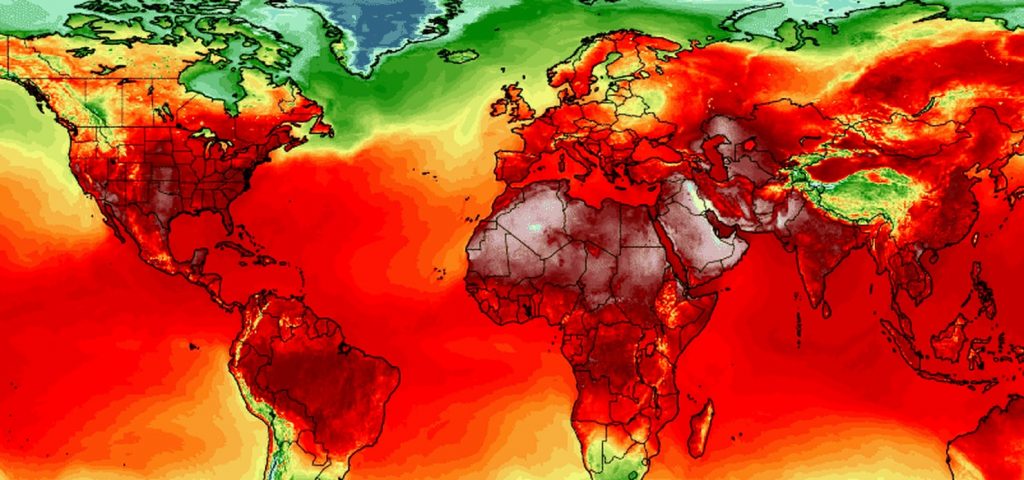
It’s been a brutally hot summer. Experts say this is just a glimpse of the future.
Denise Chow
In a summer already full of extreme weather,it’s the heat waves roasting hundreds of millions of people across three continents that are confirming a grim climate prophecy for many experts.
Sizzling temperatures in the United States and Canada and persistent heat in parts of Europe and northern Africa are creating dangerous health conditions, aggravating droughts and fueling wildfires around the world. And it’s this troubling confluence of climate threats that researchers have been warning about for two decades.
“Climate scientists were predicting exactly these kinds of things, that there would be an enhanced threat of these types of extreme events brought on by increased warming,” said Jonathan Martin, a professor of atmospheric science at the University of Wisconsin-Madison. “It’s very distressing. These are not encouraging signs for our immediate future.”
While August is typically one of the hottest months in the Northern Hemisphere, this week’s heat waves add to a growing list of recent extremes. The National Oceanic and Atmospheric Administration announced Friday that July was the hottest month since record-keeping began 142 years ago. Catastrophic flooding killed more than 200 people in Europe last month, and wildfires are raging in Siberia, across the Mediterranean and along the western coasts of the U.S. and Canada.
But to many experts, these events offer just a glimpse of what lies ahead in future summers because of climate change.
This week, a United Nations panel released an alarming report on the state of climate change and the consequences of further global warming. The assessment highlighted the threat of extreme weather events, including how global warming will make heat waves both more frequent and more intense.
The U.N.’s Intergovernmental Panel on Climate Change found that severe heat waves that previously occurred once every 50 years will now likely happen once per decade. And in a study published last month in the journal Nature Climate Change, scientists determined that record-shattering heat events are up to seven times more likely to occur between now and 2050, and more than 21 times more likely to occur from 2051 to 2080.
The oppressive heat that blanketed the Pacific Northwest early this summer demonstrated how dangerous heat extremes can be. Hundreds of deaths were linked to the June heat wave, and more than 35 cities across Washington state and Oregon tied or set new temperature records.
“The heat event that we had in the Pacific Northwest in June — it’s not that we’re suddenly going to see that every summer, but the recent extremes are certainly a preview of what we’ll see more frequently in the future,” said Karin Bumbaco, a research scientist at the University of Washington and Washington’s assistant state climatologist.
Heat waves occur when a ridge of high pressure parks over a region, suppressing cloud formation and causing air to compress and warm. The resulting heat domes have been associated with tropical cyclone activity, which can alter the circulation of air over the Northern Hemisphere and trigger unusual weather patterns.
Heat waves occur naturally in the summer, but climate change is exacerbating these events because emissions of heat-trapping greenhouse gases are causing average temperatures to increase. These changes to baseline temperatures mean that when heat waves do occur, they are more likely to be severe, said Gerald Meehl, a senior scientist at the National Center for Atmospheric Research in Colorado.
“If average temperatures are increasing everywhere, that increases the odds of more intense heat events,” he said. “Even relatively small increases in average temperatures cause a much bigger shift in the extremes.”
Extreme weather events, including heat waves, are driven by a complex mix of atmospheric processes and can vary from year to year, but climate change helps amplify the threats, said Philip Mote, a climate scientist at Oregon State University.
Global warming can also create feedback loops that then make other extreme events more likely to occur. Droughts, for instance, can intensify heat waves because the sun can more easily heat the ground when there is less moisture in the soil to evaporate.
“Right now, we have drought conditions over half the country, so that’s also playing into why we’re seeing so much heat this summer,” Bumbaco said.
Yet even while climate scientists have spent the past few decades projecting the effects of global warming, Mote said the intensity and pace of changes to the planet have been surprising.
“I’ve been involved with climate research for 23 years, and I honestly didn’t think it would get this bad this fast,” he said. “This isn’t really news to anyone who have been studying this for a while, but it’s depressing to see it coming true.”