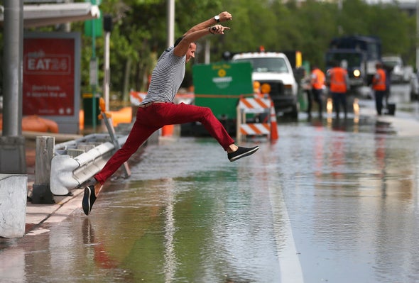
Nearly 200 million in U.S. under heat advisories, warnings as two heat domes form
Andrew Freedman
Nearly 200 million Americans are under heat advisories or excessive heat warnings as dual “heat domes” affect the Pacific Northwest, Central states and East Coast.
Why it matters: Extreme heat can kill, and it can also greatly aggravate wildfire conditions, making it even harder for thousands of firefighters to contain California’s Dixie Fire, the state’s second-largest on record.
Although it is summer, it’s unusual to see so much of the Lower 48 states experiencing extreme heat simultaneously.
The big picture: An area of upper level high pressure, also known as a heat dome, is parked over the Pacific Northwest, just off the coast of Washington State. The air circulation around this high is bringing winds off land areas land areas in British Columbia, rather than the typical cooling ocean breezes that this region is more known for.
The Northwest is a region that has already seen a record-shattering heat wave that set all-time temperature milestones in late June into early July.
High temperatures in Portland, Ore., are forecast to reach 98°F Wednesday, and 100°F on Thursday and Friday before cooling down for the weekend. The typical high temperature in Portland at this time of year is 83°F.
Red flag warnings are up for wildfire zones in northern California and parts of Oregon, and excessive heat warnings stretch from extreme northern California into Washington State. A state of emergency due to the heat wave is in effect in Oregon.
The heat is also worsening fire conditions in British Columbia, where blazes started during the June heat wave.
Heat advisories also extend from Michigan to Texas, with high humidity making for especially dangerous conditions near the urban heat islands of Kansas City and St. Louis.
Threat level: Heat advisories also stretch from North Carolina to Maine, which are under the influence of a “Bermuda High,” so named for its tendency to be located near Bermuda or between Bermuda and the East Coast at this time of year.
Currently, the high pressure area is located over the Southeastern U.S. and the southwesterly flow of air up the East Coast is bringing the heat and humidity.
Excessive heat warnings, which are a more severe type of alert, are in effect for New York City and Philadelphia, where heat indices will reach or even exceed 105°F on Wednesday and Thursday, with the hottest conditions expected Thursday.
“Extreme heat and humidity will significantly increase the potential for heat related illnesses, particularly for those working or participating in outdoor activities,” the National Weather Service said.
Washington, D.C. could hit 100°F on Thursday, with a heat index higher than that.
Context: Climate change caused by the burning of fossil fuels for energy is causing a significant rise in the intensity and probability of extreme heat events, a landmark U.N. sponsored scientific panel in a report released Monday concluded.
It warned of even more “unprecedented” heat events, like the one in the Pacific Northwest in June, to come as global warming continues.
What’s next: The heat in the Pacific Northwest should abate during the next several days, while conditions gradually moderate in the East as well. However, an overall pattern of above average temperatures in the West, in particular, is likely going to continue, in large part due to the severe drought in place in the region.
From the looks of things, willful ignorance is going to be the death of us | Opinion
Leonard Pitts Jr.
“Nothing in all the world is more dangerous than sincere ignorance and conscientious stupidity.” Martin Luther King
Dr. King didn’t know the half of it.
Those words, after all, are from 1963. Back then, the idea of U.S. citizens and lawmakers attacking their own democracy would have been unthinkable, flouting precautions in a deadly pandemic unimaginable, ignoring a threat to our very planet inconceivable. Of course, back then, information came through a few reliable conduits: Walter Cronkite, Chet Huntley, David Brinkley, the local paper.
There was no social media. The production and distribution of information had not yet become the province of any and everybody.
Things have changed. The unthinkable, the unimaginable and the inconceivable are hard upon us. We face not one, but three simultaneous existential emergencies, and while each is distinct, it’s time we understood that, ultimately, they are not different threats at all, but rather different manifestations of the same threat. Meaning that the insurrection crisis, the COVID crisis and the climate-change crisis are really, at bottom, just facets of a misinformation crisis.
If you consider how belief in risibly false information ginned up by social media — e.g., Donald Trump won, vaccines magnetize skin, cold snaps disprove global warming — has impeded if not paralyzed our response to these and other issues, the truth of it becomes evident. Cronkite, Huntley and Brinkley are long dead, the local paper just a shadow of itself. Social media purport to fill the void and as a direct result, misinformation has reached critical levels.
It’s not that no one saw this coming. Warnings go back at least two decades, including in this very space. But the threat seemed so theoretical. Who knew that it would have such real and profound effects? Who knew it would cleave this country — this planet — like an axe, splitting the informed off so decisively from the proudly misinformed, the adherents to crackpot theories and screwball beliefs that would have been laughed off the public stage in 1963 but that, in 2021, find strength in numbers and validation online? And that now emerge as a clear and present danger.
Just this week, for instance, a United Nations panel issued a report warning that climate change has brought us to the point of catastrophe: “code red for humanity.” It’s a truth underscored by our own eyes, by the hundred-year events that now happen every year: devastating floods, blistering heat, raging fires, rampaging storms. The damage, we are told, is irreversible. We can only mitigate it.
You’d think such a dire prognosis would leave us united on the need for immediate action, but Fox “News” saw little to worry about, bringing on climate denier Marc Morano to assure viewers that the U.N. just wants to take their cars. “You’re being conned,” he said, “if you’re falling for this U.N. report.”
And so it goes.
The need to teach our children well — media literacy and critical thinking, in particular — has never felt more urgent. Indeed, it is not too much to call it a matter of survival. After all, the insurrection crisis threatens our country, the COVID crisis threatens our health and the climate crisis threatens the only planet we’ve got. But the misinformation crisis either caused or exacerbated them all. So the obvious epitaph if we do not survive these challenges would be ignominious, but fair:
Chile’s record-breaking drought makes climate change ‘very easy’ to see
Esteban Medel
A cow is seen on a land that used to be filled with water, at the Aculeo Lagoon in Paine
SANTIAGO (Reuters) – A punishing, decade-long drought in Chile has gone from bad to worse due to a scorching July, a month which typically brings midwinter weather showering the capital Santiago in rain and snow.
But a lack of precipitation this year has left the towering and typically snowcapped Andes above the city mostly bare, reservoir levels low and farm fields parched. The scenes, government officials say, are clear evidence of global warming.
On Tuesday, a central Santiago weather station had recorded just 78 mm (3 inches) of rainfall so far this year compared to last year’s 180 mm and an average amount of 252 mm, according to Chile’s Meteorological Service.
Science Minister Andres Couve told Reuters on Tuesday that the steady decline in water reserves due to climate change was now a “national priority.”
He added the government was addressing the crisis by investing in water conservation and storage, creating a post for a subsecretary of water and establishing a scientist working group on water management, as well as a climate change observatory.
“We already have overwhelming evidence and it is climatic evidence,” he said. “We are seeing a very significant decrease in rainfall and that is generating water shortages.”
On Monday, United Nations climate scientists warned that extreme heat waves, which not long ago struck once every 50 years, are now to be expected once per decade.
Droughts and downpours are also becoming more frequent, the Intergovernmental Panel on Climate Change (IPCC) report said, and humans are “unequivocally” to blame through greenhouse gas emissions.
Couve said Chile, a long thin nation with the world’s driest deserts at its north, glaciers, forests and wetlands throughout and the Antarctic at its south, had bountiful proof of climate change in action.
“The scientific evidence is there but also the weather events are happening with a frequency and intensity that makes it very easy for people to see,” he said.
‘DAY ZERO’
Some scientists and politicians in Chile are warning of growing, and potentially irreversible, water shortages in the central region whose Mediterranean climate has made it home to vineyards and farms, as well as a third of its population in Santiago, the country’s economic engine.
Two rivers that provide Santiago with water – the Mapocho and the Maipo – are drier than they were in 2019, the driest year in Chile’s history, Public Works Minister Alfredo Moreno said, prompting regulators to clamp down on water use and seek alternative sources.
Chile’s utilities companies have invested heavily in new infrastructure to avoid the arrival of “Day Zero,” – the day the taps run dry, a threat which prompted major water restrictions in Cape Town, South Africa, and Chennai, India, in recent years.
That day however “arrived almost a decade ago for nearly 400 thousand people who inhabit rural areas of Chile and today receive water in tanker trucks,” said Raul Cordero, University of Santiago climatologist and leader of its Antarctic Investigation Group.
Cordero said the situation faced by rural communities in central Chile is likely to spread and worsen over time.
“It is unlikely the precipitation we once had in the central region in the 1980s and 1990s (will) return, or that we recover that climate,” he said.
Chile must build more reservoirs and desalination plants, which are increasingly relied on by its critical mining sector, he added.
“Our only advantage is we now know how climate change will hit us hardest, so we know what we need to do to face the consequences,” he said.
(Reporting by Reuters TV, writing by Dave Sherwood and Aislinn Laing; Editing by Aurora Ellis)
Nice Surprise: Africa’s first digital map of its land reveals a surprising fact about its trees
By Seth Onyango, Bird contributor August 10, 2021
New FAO digital land use study reveals that in Africa there are about 7 billion trees not counting major woodlands like the Congo rainforest.
From Our Obsession – The climate economy. Every industry can be part of the solution — or part of the ongoing problem.
As Africa registered a significant first, becoming the first continent in the world to complete its digital land-use data, new revelations emerged about its trees outside of key forests in Africa. There are more trees in Africa than initially thought, with the latest study showing there are about 7 billion trees on the continent, not counting the continent’s major woodlands like the Congo rainforest. This is according to a recent study by the Food and Agriculture Organisation.
The open data initiative that covered the period between 2018 and 2020, disclosed more forests and arable lands than were previously detected.
FAO said the findings reveal huge opportunities for the management of the environment, agriculture, and land use in Africa, and increase countries’ ability to track changes and conduct analyses for informed sustainable production, restoration interventions, and climate action.
Consequently, countries can detect where deforestation is happening, where settlement land is encroaching on cropland or grassland and where the wetland is being lost.
Africa is the first continent to complete a digital land use study of this type
The African Union Commission (AUC) revealed that the continent is the first to complete the collection of accurate, comprehensive, and harmonized digital land use and land-use change data under the Africa Open DEAL initiative. DEAL stands for Data for the Environment, Agriculture, and Land Initiative.
“Africa Open DEAL initiative has made Africa the first continent to complete the collection of accurate, comprehensive, and harmonized digital land use and land-use change data,” FAO and the AUC said at the virtual launch of the initiative July 13, 2021.
The collection of digital land-use data is crucial in agricultural policymaking.
“This collaboration has…assured that we can still turn the tide, that we can still restore degraded land for agricultural use, through models such as agroforestry, that we can still halt desertification, that we can still fight climate change, and above all that we can still restore hope for humanity despite the odds,” said Josefa Sacko, the African Union Commissioner for Agriculture, Rural Development, Blue Economy, and Sustainable Environment.
Moreover, land-cover data is used as basic information for sustainable management of natural resources; it is increasingly needed for the assessment of impacts of economic development on the environment.
According to Down To Earth, Collect Earth, free and open-source software developed by FAO, was used to collect data through Google Earth.
It is part of the set of tools called Open Foris and was developed in 2017 in collaboration with Google Earth, Bing Maps, and Google Earth Engine.
The data was analyzed to highlight land-use change over the past two decades and the potential for restoration at the national level for every country in the African continent.
“This initiative showed that science and innovation could provide real solutions and that collaboration and pooling experience led to the best results,” Qu Dongyu, FAO director-general, said in his statement.
The initiative further revealed that 350 million hectares of cropland are cultivated in Africa. This is a 25% jump over the cropland in the continent. FAO estimates show, in 2018, 279 million hectares of cropland were cultivated in the continent.
This story was republished with the permission of bird, a story agency under Africa No Filter.
Welcome to NC Voices, where leaders, readers and experts from across North Carolina can speak on issues affecting our communities.
Learn from Miami regarding NC 12. Start planning now for it to disappear.
Staff
The Army Corps of Engineers is planning to build sea wall around downtown Miami, 20 feet high in places, to protect the city from storm surges and flooding.
The problem is that Miami sits atop porous limestone through which rising sea waters will soon flood the city — a 100-foot seawall would not make a difference. The rising water from below is well known and understood, and it may have played a role in the recent Miami area building collapse.
It seems some planners in Miami just can’t get their heads around the catastrophe that the city faces — a catastrophe that could lead to eventual abandonment and 4 million environmental refugees fleeing north.
The Highway 12 situation along the Outer Banks has similarities to the Miami situation. There is not the slightest doubt that N.C. 12 is a goner. The only question is when.
University of Miami geologist Hal Wanless argues that a 2- to 3-foot sea level rise will halt development on all the world’s barrier islands. It’s not that the islands will be under water; it’s that low spots will be under water and access roads will be flooded and washed away.
Current estimates of global sea level rise range from 3 to 8 feet max by the end of this century assuming that we don’t reduce the rate of carbon dioxide release.
The evidence pointing to intensifying storms and accelerating rise in sea levels is clear. Oceanographer John Englander has shown that based on satellite observations the sea level rise rate more than doubled between 2000 and 2020.
The Highway 12 situation is not only ripe for increased rates of erosion and island overwash, but the possibility of damaging seaward overwash is greatly increased because of the large bodies of water behind the islands — Pamlico and Albemarle Sounds.
Barrier island dwellers should accept these facts as the gospel truth. They should not delay until the wolf is at the door, which is the case in Miami. Instead, learn from Miami and start planning now.
For planning purposes, I believe the assumption of a decade long maximum future lifespan for N.C. 12 is a reasonable one.
Orrin H. Pilkey. The writer is a professor emeritus of Earth Sciences at Duke University’s Nicholas School of the Environment.
Geoengineering marks scientific gains in U.N. report on dire climate future
Jake Spring
Sunrise is seen from Thyssenkrupp’s test tower in Rottweil
(Reuters) – Geoengineering science is advancing, but the question remains – should we use it?
The U.N. climate report https://www.ipcc.ch/report/ar6/wg1 released Monday presents a major leap forward in predicting how geoengineering to limit global warming might affect the planet, although scientists said the greatest hurdle remains deciding whether to use the controversial methods.
Geoengineering involves large-scale interventions that shift the climate, generally with an aim of cooling the earth.
The United Nations panel addressed two types of geoengineering in the report – solar radiation management and greenhouse gas removal.
But the report makes no recommendations on whether to use either method. The panel could give guidance on how decisions on geoengineering should be made in another report due in 2022.
Solar radiation management techniques generally control how much sunlight is reflected back out into space, preventing it from heating the earth.
Climate models previously focused on how solar radiation management would change the planet’s overall average temperature. But the models run on supercomputers have rapidly become much more sophisticated in predicting variations from the earth’s poles to equator and between hemispheres, said Govindasamy Bala, a lead author of the report from the Indian Institute of Science.
They can also better project how geoengineering could alter the amount of rain and snowfall, he said.
This would allow for more advance uses of multiple forms of solar radiation management at the same time to control for both temperature and precipitation.
For example, humans could spray sulfate aerosols – tiny reflective particles – into the stratosphere 20 to 25 kilometers (12 to 16 miles) above the earth’s surface to reflect more sunlight back into space, which lowers global temperatures.
But sulfate aerosols have the side effect of also lowering average precipitation. A separate method to thin out cirrus clouds in the upper atmosphere could offset the effect and increase precipitation, Bala said.
“The science is there,” Bala said.
“I think the next big question is, do you want to do it? … That involves uncertainty, moral issues, ethical issues and governance,” he said.
That’s because every region would be affected differently. While some regions could gain in an artificially cooler world, others could suffer by, for example, no longer having conditions to grow crops.
He said his personal assessment is that a world that overshoots the Paris Agreement targets of limiting warming to 1.5 to 2 degrees Celsius would be better off using geoengineering. But he is pessimistic the world’s governments could come to agreement on it.
Paulo Artaxo, another lead author and an environmental physicist at University of Sao Paulo, said he interprets the report as still emphasizing caution when it comes to geoengineering.
“Basically the message is more or less the same as (the previous report): The science is not mature enough,” Artaxo said.
“The side effects of any of the known geoengineering techniques can be very significant… Society has to consider if these side effects are too big to try any strategy.”
CARBON REMOVAL
While solar radiation management remains on the periphery of climate discussions, carbon dioxide removal has been accepted as a necessary tool for mitigating climate change, said Chris Field, an earth scientist at Stanford University.
“That’s become more clear with the recognition we’re going to need negative emissions…and almost by definition negative emissions have to be through some kind of carbon dioxide removal,” said Field, who was not involved in this IPCC report.
This U.N. report expressed much higher confidence regarding the use of carbon dioxide removal to help limit rising levels of the greenhouse gas in the atmosphere, said Leticia Cotrim da Cunha, a lead author and oceanographer at Rio de Janeiro State University.
There are a wide variety of methods of greenhouse gas removal including technological solutions like using massive machines to filter carbon dioxide out of the air, or capturing carbon emissions from factories or fossil fuel drilling and injecting it into certain underground rocks to contain it.
Carbon dioxide can also be removed from the atmosphere by using forests or by encouraging plant growth in the ocean.
The report focuses on greenhouse gas removal as a whole without making recommendations on the merits of individual methods, Cunha said.
Greenhouse gas removal cannot solve climate change by itself and must go together with cutting back how much carbon dioxide is being emitted in the first place, she said.
“We can’t go on emitting this much CO2 and just try to remove all the excess CO2 from the atmosphere,” Cunha said.
“We would need an extra planet to put all the CO2.”
(Reporting by Jake Spring in Brasilia; Editing by Lisa Shumaker)
Heat, drought and fire: how climate dangers combine for a catastrophic ‘perfect storm’
Gabrielle Canon
Photograph: Fred Greaves/Reuters
Northern California’s Dixie fire this weekend swelled to become the single largest fire incident the state has ever recorded, a mammoth that has leveled mountain towns, produced flames that shot 200ft in the air, and scorched through close to 490,000 acres.
“It is just the perfect storm,” says Rick Carhart, the California department of forestry and fire protection (Cal Fire) public information officer, adding that the difficult and steep terrain, parched vegetation, and hot, dry weather had all come together to fuel the conflagration that has sent flames 200ft into the sky.
And, he says, the Dixie fire was just one of a series of large blazes that have affected the area in recent years. “It has been giant devastating fire after giant devastating fire.”
Researchers are concerned that the Dixie fire’s record won’t hold for long. The parched landscapes and increased temperatures that set the stage for bigger blazes this year are not anomalies – they are trends. And the conditions are going to get worse.
A climate crisis trifecta
Drought, extreme heat, and destructive infernos are each devastating in their own right, but together they cause calamity. The combination augments their effects and causes each individual condition to intensify. Scientists say they are seeing the trifecta more frequently in the west and that climate breakdown is the key culprit.
“This is what climate scientists have been warning about for years now,” says Park Williams, a hydro-climatologist at the University of California, Los Angeles.
Drought and fire have always been part of the climate in the western US, but increasing heat, which scientists say is directly attributable to human-caused climate change, has had a devastating impact. “These things amplify each other,” Williams says, adding that the effects exponentially increase.
The climate conditions don’t act alone, and fire and and water policies play a part in increasing risks and determining the outcome as well. Most fires are still started by people. The expansion of communities in forested and fire-prone areas adds new dimensions that complicate containment efforts when blazes get big. But what’s happening in the environment has made fires much harder to fight.
That’s why new records don’t just nose out the old ones – they obliterate them. In 2020, the 4.2m acres that burned in California was nearly triple the previous record. This year, fires have burned more than three times as much land as they had by this point in 2020, according to Cal Fire.
“And there’s really no end in sight for the capacity for that type of thing to happen again,” Williams says.
A vicious cycle of heat and drought
Heat affects drought in several ways. Higher temperatures cause precipitation to fall as rain rather than snow. Snow that does fall melts away much more quickly, leaving less to trickle into streams, rivers, and reservoirs. People, plants and animals depend on the snowpack to feed the water systems and with less available, the landscape and anything living in it or off of it will feel the strain.
Heat also bakes moisture right out of the landscape. The hotter it is, the more water plants and animals need to regulate themselves, and that increases water scarcity even further. What makes all this more complicated is that the relationship works in the other direction as well – drought conditions increase heat.
“Heat is both a response to drought and also a driver of drought,” says Andrew Hoell, a meteorologist for the National Oceanic and Atmospheric Administration’s physical sciences laboratory. Dry soils radiate and reflect the sun’s energy that otherwise would be used in evaporation. That pushes surface temperatures even higher.
“Just like we get cold when we climb out of a swimming pool, the earth cools off when water evaporates,” Hoell says. “When soils are dry, when it’s hot out, there isn’t as much water available to evaporate. That means the earth doesn’t get to cool off.”
That’s why Hoell calls climate change a “threat multiplier”. As the region becomes hotter and drier, the risk of small sparks quickly igniting into enormous and erratic wildfires magnifies.
Fires add another dimension to the threat
New research also suggests that the wildfires themselves will increase drought and heat, adding a new dimension to the catastrophic cycle. Researchers are discussing hypotheses, Hoell explains, that smoke and aerosols released into the atmosphere by wildfires can alter weather patterns. There are already studies that show wildfires influence the formation of clouds in the sky and could decrease precipitation.
“It is very dynamic and very complicated but that’s where we are going as a science community – we are trying to figure out how wildfires feed back on to drought,” he said.
Researchers are also investigating how reduced canopies from forests decimated in fires expose the snowpack that was once shaded to the sun.
Although more research is needed to better understand these complex relationships, the scientific record is clear that rising heat will lead to an increase in extreme events.
“Global surface temperature will continue to increase until at least the mid-century under all emissions scenarios considered,” according to the Intergovernmental Panel on Climate Change in its sixth report, released on Monday, which went on to detail and list the expected increase in both frequency and intensity of hot extremes, ecological droughts, and the reductions in Arctic sea ice, snow cover and permafrost, along with other catastrophic conditions.
“Under all future scenarios and global warming levels, temperatures and extreme high temperatures are expected to continue to increase,” the report said of North and Central America, attributing the rise to “human influence”.
Models show that extreme heatwaves are expected to happen more frequently, more intensely, and across larger areas of land in just the next three decades. “Historically we have had between four and six extreme heat events in any given year,” said Steve Ostoja, director of the USDA California Climate Hub. “By 2050, we expect that number to go somewhere between 25 and 30 events. That’s a huge difference. That basically means it is going to be that hot all the time.”
No time to lose
The trends are already being felt. Currently, about half of the contiguous US is in drought, according to federal agencies. The entire state of California is experiencing drought conditions, with more than 88% of the state in the “extreme drought” category, as determined by the US Drought Monitor. Meanwhile, dozens of climate stations across the west documented the warmest June and July on record, as extreme heatwaves spiked temperatures across the region.
Climate scientists say that there is still time to make big changes, and there’s a chance that the worst effects of the changing climate can be staved off. But there’s no time to lose.
In the west, the wildfires, drought, and heat are already wreaking havoc. Williams, the climate scientist from UCLA, says there are clear indications that places like California won’t look like they do now for much longer. The landscape is growing arid, and as it gets drier and hotter, there will be more fires. That will lead to fewer forests and more grasslands, shrublands, and deserts.
“Fire has been around for hundreds of millions of years and it is a critical part of the earth’s system,” he said. But the fires of the future will do much more than clear the underbrush. “Now the fires we are seeing are eliminating giant patches of forest entirely,” he added, explaining that many tree species had not evolved to repopulate the giant gaps quickly.
“It could take hundreds of years for ponderosa or Jeffrey pine – which we see a lot of in the Sierra Nevada – to actually reoccupy giant patches of forest,” he said. “By that time the climate might be totally inappropriate for those species anyway.”
How elite, oil-backed think tanks worked to lift the ban on US crude oil exports
by Rob Galbraith
Brookings Institution senior fellow Charles Ebinger testifies before Congress in favor of lifting the crude oil export ban in 2014(via C-SPAN)
In early July, Brookings Institution Vice President Darrell M. West blasted Unearthed, an investigative journalism project of Greenpeace UK,in a since-deleted post on the Brookings blog for secretly recording ExxonMobil lobbyists candidly disclosing the company’s playbook for blocking government action on climate change.
Lawrence Carter, a reporter at Unearthed, had published an exposé based on undercover interviews with two ExxonMobil lobbyists who revealed how the company persuaded lawmakers to drastically limit the scope of the Biden administration’s infrastructure bill, backed proposals for a carbon tax to give the appearance of supporting climate action in the belief that the policy was unlikely to ever pass, and backed “shadow groups” to undermine the scientific consensus on climate change.
After West criticizedthe Unearthed report as “erod[ing] trust in civic life,” Kate Aronoff pointed out that Brookings is funded by ExxonMobil and was explicitly named, along with the Center for Strategic and International Studies (CSIS), as one of “the two big think tanks that we work with and that we’re actively involved in” by one of the ExxonMobil lobbyists in the report.
Aronoff noted in her article at The New Republicthat “funding the institutions that help define ideas about what constitutes a reasonable climate debate” can help ExxonMobil and other fossil fuel companies influence climate policy in ways that are hidden to the general public.
Indeed, while the lobbyists’ unwitting admissions to Unearthed revealed ExxonMobil’s tactics in particularly stark terms, Big Oil’s use of think tanks to shape policy is nothing new. We documented this phenomenon as it related to a specific policy debate in our 2015 report “The Oil Tanks.” The report examined fossil fuel industry funding for Brookings, CSIS, and seven other elite think tanks advocating for repealing the ban on exporting crude oil from the United States.
In 2014, Brookings published a report titled “Economic Benefits of Lifting the Crude Oil Export Ban” written by Charles Ebinger, a senior fellow at Brookings with a long history of advising energy companies and governments on energy issues. In that year Brookings reported receiving between $1.7 and $3.6 million from nine major oil and gas companies, including between $500,000 and $999,999 from ExxonMobil. Further, at the time 15 of Brookings’ 74 were current or former directors, executives, or lobbyists of oil and gas companies who gave an additional $1.3 to $3.1 million to the institute.
Other think tanks profiled in our report who worked to lift the crude oil export ban while taking money from the fossil fuel industry include CSIS, the Council on Foreign Relations, the Cato Institute, the Heritage Foundation, the American Enterprise Institute, the Atlantic Council, the Aspen Institute, and the Bipartisan Policy Center.
In her article, Aronoff describes the influence that Brookings and other elite think tanks funded with fossil fuel money and other corporate donations have on US policy: “These institutions often feed experts to top posts in the White House and serve as landing pads for ex-administration officials when their parties lose control, weighing in on key policy debates with recommendations for lawmakers.”
We observed this precise dynamic in our 2015 report on the effort to allow oil drillers to begin exporting crude oil from the United States.
Frank Verrastro, senior advisor to the Center for Strategic and International Studies’ energy security and climate change program and lead author of the report “Delivering the Goods: Making the Most of North America’s Evolving Oil Infrastructure,” held positions in the White House energy policy and planning staff as well as the Department of Interior’s oil and gas office and the Department of Energy’s domestic policy and international affairs office, according to one bio.
David Goldwyn was co-director of the Atlantic Council’s pro-export report “Empowering America: How Energy Abundance Can Strengthen US Global Leadership.” Previously, as Special Envoy for International Energy Affairs in the State Department, Goldwyn was critical to the Obama administration’s strategy of encouraging eastern European countries to embrace fracking and lease land to US oil companies, including Chevron, a major Atlantic Council donor. Goldwyn has also held roles at other elite, fossil fuel-funded think tanks that promoted lifting the export ban. From 2001 until 2009 when he joined the federal government, Goldywn was a senior associate at CSIS. In 2007, Goldwyn was a member of a Council on Foreign Relations task force on National Security Consequences of U.S. Oil Dependency. In 2014, Goldwyn was a member of the Brookings Institution’s natural gas task force, which endorsed liquefied natural gas (LNG) exports.
Overall, as we observed in 2015, the effect was to create an “echo chamber of highly influential institutions funded, directed, and staffed by many of the same corporations and people and delivering the same pro-industry messages,” through 2014 and 2015 calling for a major policy shift to benefit the United States oil industry. On December 18, 2015, just two weeks after we published our report, then-President Barack Obama signed a bill lifting the export ban. Now, thanks to the reporting of Lawrence Carter at Unearthed and Kate Aronoff at The New Republic we have evidence, in Exxon’s own words, of how they use elite liberal and right-wing think tanks to advance their agenda in Washington.
‘Code Red for Humanity’: IPCC Report Warns Window for Climate Action Is Closing Fast
By Jake Johnson at Common Dreams August 9, 2021
“The alarm bells are deafening, and the evidence is irrefutable: greenhouse gas emissions from fossil fuel burning and deforestation are choking our planet and putting billions of people at immediate risk.”
Wildfire in the Pacific Northwest Credit: BLM Oregon & Washington. CC By 2.0
A panel of leading scientists convened by the United Nations issued a comprehensive report Monday that contains a stark warning for humanity: The climate crisis is here, some of its most destructive consequences are now inevitable, and only massive and speedy reductions in greenhouse gas emissions can limit the coming disaster.
Assembled by the International Panel on Climate Change (IPCC) — a team of more than 200 scientists — the new report represents a sweeping analysis of thousands of studies published over the past eight years as people the world over have suffered record-shattering temperatures and deadly extreme weather, from catastrophic wildfires to monsoon rains to extreme drought.
The result of the scientists’ work is a startling assessment of the extent to which human activity, particularly the burning of fossil fuels, has altered the climate, producing “unprecedented” planetary warming, glacial melting, sea level rise, and other changes that are wreaking havoc in every region of the globe — wiping out entire towns, imperiling biodiverse ecosystems such as the Great Barrier Reef and the Amazon rainforest, and endangering densely populated swaths of the world.
“This report is a reality check,” said Valérie Masson-Delmotte, a climate scientist at the University of Paris-Saclay and co-chair of the panel that produced the report. “We now have a much clearer picture of the past, present, and future climate, which is essential for understanding where we are headed, what can be done, and how we can prepare.”
One central finding of the new analysis is that the Paris accord’s goal of limiting global temperature rise to no more than 1.5°C above pre-industrial levels is in serious danger as policymakers fail to take the necessary steps to curb greenhouse gas emissions.
Each of the past four decades, according to the report, has been successively warmer than any preceding decade dating back to 1850, atmospheric CO2 has soared to levels not seen in two million years, and “global surface temperature will continue to increase until at least the mid-century under all emissions scenarios considered.”
“Global warming of 1.5°C and 2°C will be exceeded during the 21st century,” the IPCC panel warns, “unless deep reductions in carbon dioxide and other greenhouse gas emissions occur in the coming decades.”
“Many of the changes observed in the climate are unprecedented in thousands, if not hundreds of thousands of years, and some of the changes already set in motion—such as continued sea level rise—are irreversible over hundreds to thousands of years,” reads the report, which was approved by 195 member nations of the IPCC.
“However,” the report emphasizes, “strong and sustained reductions in emissions of carbon dioxide and other greenhouse gases would limit climate change. While benefits for air quality would come quickly, it could take 20-30 years to see global temperatures stabilize.”
Panmao Zhai, another co-chair of the IPCC working group, stressed that “stabilizing the climate will require strong, rapid, and sustained reductions in greenhouse gas emissions, and reaching net-zero CO2 emissions.”
“Limiting other greenhouse gases and air pollutants, especially methane, could have benefits both for health and the climate,” Zhai added.
The planet has warmed at an unprecedented rate, the IPCC report states.
The new report, the first of three installments, was released just weeks before world leaders are set to gather in Glasgow for the 2021 United Nations Climate Change Conference (COP26), which activists view as a pivotal moment for the global climate fight.
“Many see COP26 as our last, best chance to prevent global temperatures from spiraling out of control,” Dorothy Grace Guerrero of Global Justice Now wrote last month. “Unfortunately, we are not yet on track to limit global warming to 1.5°C, the threshold that scientists agree will prevent the most dangerous climate impacts. Failure to reach this goal will take a disproportionate toll on developing countries.”
António Guterres, secretary-general of the U.N., said in a statement Monday that the IPCC’s latest findings are “a code red for humanity.”
“The alarm bells are deafening, and the evidence is irrefutable: greenhouse gas emissions from fossil fuel burning and deforestation are choking our planet and putting billions of people at immediate risk,” said Guterres. “Global heating is affecting every region on Earth, with many of the changes becoming irreversible.”
“There is a clear moral and economic imperative to protect the lives and livelihoods of those on the front lines of the climate crisis,” Guterres continued. “If we combine forces now, we can avert climate catastrophe. But, as today’s report makes clear, there is no time for delay and no room for excuses. I count on government leaders and all stakeholders to ensure COP26 is a success.”
This article was republished from Common Dreams under Creative Commons (CC BY-NC-ND 3.0)
Higher water levels in Lake Okeechobee may be part of new Army Corps plan
Adriana Brasileiro
Lake Okeechobee may be kept at higher levels for longer periods of time under a new management plan the U.S. Army Corps of Engineers is refining now that a $1.8 billion upgrade of the Herbert Hoover Dike is nearly completed.
The Corps picked a preferred alternative, called “CC,” out of six choices and will now work on fine-tuning the plan based on extensive feedback from environmentalists, agriculture representatives, Native American tribes and other leaders on how to balance the conflicting demands on lake waters..
“We are building on the CC foundation in order to get every ounce of benefit out of the new plan,” Col. Andrew Kelly, the Corps commander for Florida, said during a presentation outlining the basics on Monday. “The technical team is now running optimization models and they will come back in September with a better defined plan,” he said.
Thick blue-green algae surrounds boats in the Pahokee Marina on Lake Okeechobee earlier this year. Blooms increased as water temperatures rose and nutrients in the shallow lake got stirred up by wind.
Priorities include reducing harmful releases of polluted lake water to the Caloosahatchee estuary on the west and to the St. Lucie on the east, and sending more water south to the parched Everglades and Florida Bay. But the plan also aims to guarantee more water to users, including the sugar industry which has vast fields around the lake. Reducing pollution in the lake and lowering the risk of harmful algae blooms that have plagued Florida’s coasts and hurt local economies were also among the consensus priorities, Kelly said.
The biggest changes from years past: A massive $1.8 billion upgrade of the dike that is scheduled to be completed next year, as well as Everglades restoration projects that will come online in the next few years. The projects include a vast reservoir and storm water treatment area that, once completed in 2023, will allow managers to send more water south when lake levels rise, reducing discharges to estuaries on the east and west.
The aim is to produce water that’s clean enough to replenish the Everglades amid efforts to recreate something close to the original flow of the River of Grass, going south through Shark Valley in Everglades National Park, taking much-needed fresh water all the way south to Florida Bay.
“While we’re encouraged by the Army Corps’ selection, the new Lake O playbook won’t be successful unless it brings relief to the Caloosahatchee estuary without sending additional water to the St. Lucie,” said Eve Samples, executive director of Friends of the Everglades. “The way to accomplish this is by sending more clean water south during the dry season, rather than stockpiling it in the lake for irrigation south of the lake.”
An algae bloom in the lake in May generated a sense of urgency and pressure on the Corps to accelerate work on the new plan, seen as a solution for the conflicting demands for water from the Everglades’ liquid heart, at least for the next decade. Environmentalists and Everglades restoration advocates argue that the lake has been managed for the needs of agriculture south of the lake, which is primarily sugar.
Farmers and those in the recreation and fishing business around the lake want assurances that they will have the water when they need it. And South Florida’s growing cities also want the certainty of uninterrupted water supply and flood control during the rainy season.
By running the lake in a more balanced way and giving its own operations more flexibility, the Corps hopes to reduce water releases that have been disastrous for the Caloosahatchee and St. Lucie estuaries. As renovation work on the dike is expected to reduce the risk of a breach, over a foot more water can be kept on the lake during the rainy season. The lake is usually kept between 12.5 feet (to guarantee water supply) and 15.5 feet (to protect the dike). Under the new plan, it could go higher than 17 feet and stay at around that level for more days, Kelly said.
Raising lake levels could have environmental ripple effects, however, on aquatic plants and fish. A higher lake may also be detrimental to the system’s ecology, drowning and killing vegetation that helps clean up nutrients that feed algae blooms.
“When the lake is over 15 feet you are killing the vegetation, and when you kill the vegetation all the water that goes west, east, south will be polluted and it will be a disaster,” Newton Cook, the president of United Waterfowlers Florida, said Monday during the meeting.
Kelly said the Corps’ technical team will run models taking into account the different comments and will present a more detailed plan in September. That plan will receive more public input through the end of October, when the Corps will set a schedule for coordination with the South Florida Water Management District and other agencies involved in the new lake management plan. Their input will be added to the process, and a draft document is expected to be ready in February, he said.