
Palm Beach Daily News
Hurricane Danielle becomes first hurricane of 2022 Atlantic season. Category 2 storm in forecast
Cheryl McCloud, Palm Beach Post – September 2, 2022
Hurricane Danielle has become the first hurricane of the 2022 Atlantic season.
Maximum sustained winds have increased to 75 mph, according to the National Hurricane Center.
Danielle is forecast to continue strengthening, with winds expected to hit 100 mph over the next 48 hours, making it a Category 2 storm.
There is no threat to the U.S. from the storm.
► Your guide to preparing for the 2022 hurricane season in Florida
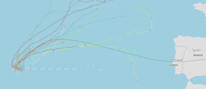
Danielle’s path will be an untraditional one, with the hurricane forecast to trace a small loop over the waters of the North Atlantic through the weekend, according to AccuWeather.
The Hurricane Center also is monitoring two other tropical waves in the Atlantic, Invest 91L and Invest 94L.
Chances have dropped overnight for the development of 91L, the closest disturbance to the U.S.
What’s happening in tropics: August hasn’t been this devoid of tropical storms since 1997. Is hurricane season over?
WeatherTiger: Baffling scot-free hurricane season thus far, but stormless streak ends with Danielle
The next named storm of the season will be Earl.
Here’s the latest update from the NHC as of 11 a.m. Sept. 2:
- Location: 885 miles west of the Azores; 2,238 east of Daytona Beach
- Maximum wind speed: 75 mph
- Direction: west at 1 mph
Maximum sustained winds have increased to near 75 mph, with higher gusts.
Some additional strengthening is forecast during the next couple of days. Winds are expected to reach 100 mph within 48 hours.
Hurricane-force winds extend outward up to 15 miles from the center and tropical-storm-force winds extend outward up to 115 miles.
What else is out there and where are they?
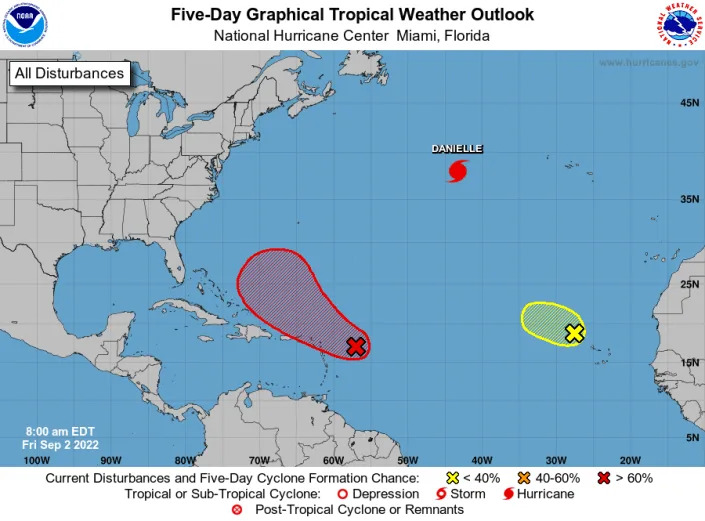
Invest 91L: Shower and thunderstorm activity has slightly increased since yesterday in association with an area of low pressure located several hundred miles east of the Leeward Islands.
Invest 94L: Shower activity associated with a broad area of low pressure located northwest of the Cabo Verde Islands has slightly increased since yesterday.
How likely are they to strengthen?

Invest 91L: Overnight satellite-derived wind data indicate the circulation remains broad. Although environmental conditions are only marginally conducive, any additional development of the system over the next few days would lead to the formation of a tropical depression.
The disturbance is expected to move slowly west-northwest, toward the adjacent waters of the northern Leeward Islands.
An Air Force Reserve Hurricane Hunter aircraft is scheduled to investigate the system this afternoon, if necessary.
- Formation chance through 48 hours: medium, 50 percent.
- Formation chance through 5 days: medium, 70 percent.
Invest 94L: This system is moving into an area of less favorable environmental conditions, and significant development is not expected.
- Formation chance through 48 hours: low, 10 percent.
- Formation chance through 5 days: low, 10 percent.
Who is likely to be impacted?
Invest 91L: Regardless of development, locally heavy rains may occur over portions of the Leeward Islands during the next couple of days, and residents in that area should monitor the progress of the system.
Invest 94L: It’s too early at this time to determine if there will be any impact to the U.S. from Invest 94L.
Forecasters urge all residents to continue monitoring the tropics and to always be prepared during what’s expected to be an active hurricane season.
Colorado State University’s two-week hurricane forecast for Sept. 1-14 calls for a 70% chance of near-normal activity, a 25% chance of above-normal activity and a 5% chance of below-normal activity.
When is the Atlantic hurricane season?
The Atlantic hurricane season runs from June 1 through Nov. 30.
When is the peak of hurricane season?
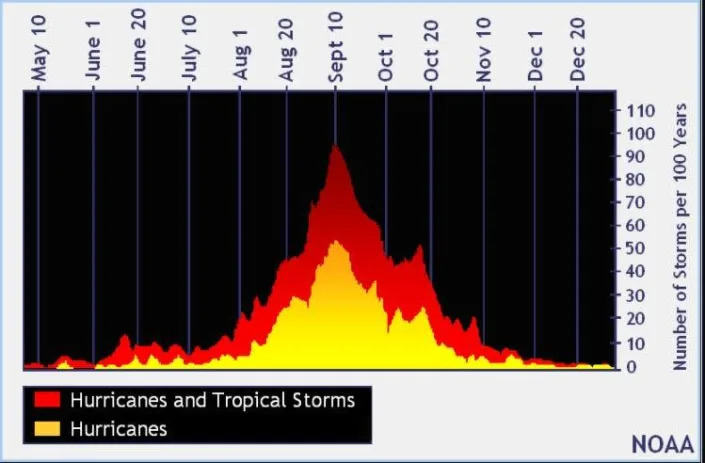
Although the season has gotten off to a quiet start, the peak of the season is Sept. 10, with the most activity happening between mid-August and mid-October, according to the Hurricane Center.
Weather watches and warnings issued for your area
If you can’t see any local weather warnings here, you’ll need to open this story in a web browser.
The next five days
See the National Hurricane Center’s five-day graphical tropical weather outlook below.
Excessive rainfall forecast
What’s out there?
Systems currently being monitored by the National Hurricane Center.
