This is now California’s worst summer COVID wave in years. Here’s why
Rong-Gong Lin II – August 12, 2024
Individuals, some wearing face masks, walk in Laguna Beach on July 28. (Zoe Cranfill / Los Angeles Times)
California’s strongest summer COVID wave in years is still surging, and an unusual midsummer mutation may be partly to blame.
There are a number of possible culprits behind the worst summer infection spike since 2022, experts say. A series of punishing heat waves and smoke from devastating wildfires have kept many Californians indoors, where the disease can more easily spread. Most adults are also well removed from their last brush with the coronavirus, or their last vaccine dose — meaning they’re more vulnerable to infection.
But changes in the virus have also widened the scope of the surge.
Of particular concern is the rise of a hyperinfectious subvariant known as KP.3.1.1, which is so contagious that even people who have eluded infection throughout the pandemic are getting sick.
“COVID is extraordinarily common now,” said Dr. Elizabeth Hudson, regional chief of infectious diseases for Kaiser Permanente Southern California’s 16-hospital healthcare system.
COVID hospitalizations are ticking up, but remain lower than the peaks for the last two summers, probably thanks to some residual immunity and the widespread availability of anti-COVID drugs such as Paxlovid.
The World Health Organization has warned of COVID infections rising around the world, and expressed concern that more severe variants could emerge.
“In recent months, regardless of the season, many countries have experienced surges of COVID-19, including at the Olympics,” said Dr. Maria Van Kerkhove, the WHO’s technical lead on COVID.
Among those caught up was 27-year-old American sprinter Noah Lyles, who after winning the gold in the men’s 100-meter finals, came up short Thursday during the 200-meter finals, taking the bronze. Lyles collapsed after the race, fighting shortness of breath and chest pain, and was later taken away in a wheelchair.
“It definitely affected my performance,” he said of the illness, estimating that he felt “like 90% to 95%” of full strength.
The rate at which reported coronavirus tests are coming back positive has been rising for weeks — to above 10% globally and more than 20% in Europe. In California, the coronavirus positive test rate was 14.3% for the week that ended Aug. 5 — blowing past the peaks from last summer and winter — and up from 10% a month ago.
There were already indications in May that the typical U.S. midyear wave was off to an early start as a pair of new coronavirus subvariants — KP.2 and KP.1.1, collectively nicknamed FLiRT — started to make a splash, displacing the winter’s dominant strain, JN.1.
But by July, a descendant strain, KP.3.1.1, had clearly taken off.
“KP.3.1.1 is extremely transmissible and a little bit more immune evasive. It kind of came out of the blue during the summer,” said Dr. Peter Chin-Hong, an infectious-diseases specialist at UC San Francisco.
Cases are up at Kaiser Permanente Southern California, and “looking through the CDC data … KP.3.1.1 is really what is driving this particular surge,” Hudson said. “We are certainly much higher than we were last summer.”
Anecdotally, some infected people report being “pretty darn miserable, actually — really severe fatigue in the first two days,” Hudson said.
People may want to think their symptoms are just allergies, she said, but “it’s probably COVID. So we’re just really encouraging folks to continue to test.”
An initial negative test doesn’t necessarily mean you’re out of the woods, though. Officials recommend testing repeatedly over as many as five days after the onset of symptoms to be sure.
California has now reported four straight weeks with “very high” coronavirus levels in its wastewater, according to data released by the U.S. Centers for Disease Control and Prevention on Friday. That followed five weeks of “high” viral levels.
Last summer, California recorded only eight weeks with “high” coronavirus levels in wastewater, and never hit “very high” levels. In the summer of 2022, California spent 16 weeks with “high” or “very high” levels of coronavirus in wastewater.
“Fewer people got immunized this year compared to last year at this time,” Chin-Hong said. “That means, particularly amongst people who are older, they’re just not equipped to deal with this virus.”
There are 44 states with “high” or “very high” coronavirus levels in their wastewater, according to the CDC. Five states, and the District of Columbia, have “moderate” levels, and there were no data for North Dakota.
The CDC said coronavirus infections are “growing” or “likely growing” in 32 states, including California; are “stable or uncertain” in seven states, as well as the District of Columbia; are “likely declining” in Connecticut; and “declining” in Hawaii and Nevada. There were no estimates in eight states.
In Los Angeles County, coronavirus levels in wastewater jumped to 54% of last winter’s peak over the 10-day period ending July 27, the most recent available. A week earlier, coronavirus levels in wastewater were at 44% of last winter’s peak.
For the week ending Aug. 4, L.A. County reported an average of 479 coronavirus cases a day, double the number from five weeks earlier. Cases are an undercount, only reflecting tests done at medical facilities — not self-tests conducted at home.
In Santa Clara County, the most populous in the San Francisco Bay Area, coronavirus levels were high in all sewersheds, including San Jose and Palo Alto.
Hospitalizations and emergency room visits related to the coronavirus are also rising. Over the week ending Aug. 3, there were an average of 403 coronavirus-positive people in hospitals in L.A. County per day. That’s double the number from five weeks earlier, but still about 70% of last summer’s peak and one-third the height seen in summer 2022.
For the week ending Aug. 4, 4% of emergency room encounters in L.A. County were classified as related to the coronavirus — more than double the figure from seven weeks earlier. The peak from last summer was 5.1%.
“We’ve had a few people who have become very ill from COVID. Those are people who tend to be pretty severely immunocompromised,” Hudson said.
UC San Francisco has also seen a rise in the number of coronavirus-infected hospitalized patients. As of Friday, there were 28, up from fewer than 20 a week earlier, Chin-Hong said.
In the Bay Area, three counties have urged more people to consider masking in indoor public settings because of the COVID surge. Contra Costa County’s public health department “recommends masking in crowded indoor settings, particularly for those at high risk of serious illness if infected,” the agency said Tuesday, following similar pleas from San Francisco and Marin County health officials.
Compared with advice such as washing hands and staying away from sick people, suggesting wearing a mask can provoke strong opposition from some.
“The moment people see this, like in their mind, it sets off this chain reaction of, like, all the negative things of the pandemic, having to have society shut down and social isolation,” said Dr. Abraar Karan, an infectious-disease doctor and researcher at Stanford University.
But masks do help reduce the risk of infection, and people don’t have to wear them all the time to benefit. Karan says he socializes and eats at indoor restaurants. But he’ll decide to mask in other situations, like “when I’m traveling,” and, obviously, at work.
Doctors say that wearing a mask is one of many tools people can use to reduce their risk, and can be especially helpful when in crowded indoor settings.
Karan said he’s seen more coronavirus-positive patients while working shifts in urgent care, and he suggested that more healthcare providers take the time to order tests. He said he worries that when people come in with relatively mild symptoms, they may be sent home without testing.
But that could miss potential COVID diagnosis, which could allow a patient to get a prescription for an antiviral drug like Paxlovid.
Without testing, “you run the risk of taking shortcuts and not prescribing people meds that they actually should technically be getting,” Karan said.
Doctors Say Walking This Much Per Day Could Decrease Disease-Causing Inflammation
Olivia Luppino, Laura Purdy, MD – August 12, 2024
7 Science-Backed Ways To Reduce InflammationCathrine Wessel
“Hearst Magazines and Yahoo may earn commission or revenue on some items through these links.”
If you’ve scrolled through TikTok lately, you’ve probably seen tons of videos about how to reduce inflammation in your body. The topic is going viral for good reason, too—inflammation is the precursor of most modern chronic diseases, says Maya Feller, RD, the founder and lead dietitian at Maya Feller Nutrition, so it’s no wonder people are concerned with it.
Inflammation isn’t always a bad thing, so you don’t want to (and can’t) rid your body of it entirely. It’s actually a normal part of your body’s immune system.
“Inflammation is a completely natural process, and it’s a response usually to either injury or infection,” says Valerie Gustave, MD, a gastroenterologist at Lenox Hill Hospital and NYU Langone Medical Center. For example, acute inflammation might occur when you get a cut or twist your ankle to help your body heal.
But when inflammation is chronic, it can be an issue. Rheumatoid arthritis, lupus, Crohn’s disease and irritable bowel syndrome are all inflammatory conditions, and symptoms like fatigue, low energy, recurrent rashes, joint pain, and unexplained stomachaches can also be caused by persistent inflammation, says Micaela Bayard, MD, a rheumatologist at Mount Sinai. For any of these conditions or symptoms, you should speak with a doctor to evaluate your inflammatory markers, confirm an issue, and help you determine the best path forward.
In addition to medicine, part of that path might include lifestyle changes. These expert-approved tips are the foundation of healthy living—and can possibly help prevent excess inflammation in the future.
If you’re dealing with fatigue, recurrent rashes, joint pain, or any of the symptoms described above, it may help to make an appointment with your doctor to rule out any chronic conditions. And if you want to take better care of yourself in general and reduce your risk of inflammation, you can start with the basics, Dr. Gustave says. Here are seven simple, science-backed ways to reduce inflammation and boost your health overall.
Drink Less Alcohol
Cutting back on booze is one way to tamp down inflammation.
“The body recognizes alcohol as a toxin,” says Feller, so it’s no surprise that it gets a big reaction from your immune system. “The problem with alcohol is that it can very actively stimulate what we call ‘pro-inflammatory molecules’ that trigger more inflammation,” says Dr. Bayard.
And if you already have a chronic condition that causes your body to be at an “elevated level of inflammation,” drinking alcohol can make things worse, she says.
Drinking alcohol contributes to systemic inflammation (the kind that causes chronic diseases) by messing with your gut’s microbiome, liver function, and even brain. And all those symptoms you get during a hangover? They’re an inflammatory response, too—and their severity might reflect systemic inflammation caused by drinking, according to a 2024 study in Alcohol: Clinical and Experimental Research. The more intense your hangovers are, the more inflammation you’re probably experiencing—and this drinking-inflammation cycle may put you at significantly greater risk of long-term health problems like significant liver damage and tissue damage in your gut, the study found.
If you’re looking to make a change, you don’t have to go cold turkey.
“Reduce in a way that is realistic for you,” Feller says. The less alcohol, the better, but “moderate drinking” for a woman is described as one drink or less per day, per the Centers for Disease Control and Prevention (CDC).
Cut Out Tobacco
Consuming tobacco in any form (cigarettes, vapes, and hookah) harms your gut and lungs, and when it comes to inflammation, smoking can put you at risk for developing chronic health issues. In fact, one of the most well-documented causes of rheumatoid arthritis is smoking. This is because inflammation—your body’s natural immune response—can be found wherever there’s cell or tissue damage, and smoking causes plenty of damage in your body, says Dr. Bayard. “If you’re inhaling something that can be damaging to the tissue, that’s an area where inflammation can then accumulate,” she says.
The bottom line? Stopping smoking will make a big difference on your overall health, and not just your inflammatory markers, says Dr. Gustave.
Get A Good Night’s Sleep
Getting enough quality sleep is easier said than done, but turns out it’s super important for your health and for mitigating inflammation in the body. This is because sleep is a vital part of our immune response. Sleep is restorative, and during sleep, your immune system releases messenger proteins that help healing and fight infections, Dr. Bayard says.
Inconsistent sleep may be associated with higher levels of inflammation, especially for women, according to a 2020 study in Frontiers in Neurology. Sleep disturbances like waking up in the middle of the night could trigger inflammatory responses in the body, the study found. Without deep, uninterrupted sleep, your body won’t have the time it needs to let your immune system regenerate and heal the acute inflammation in your body, says Dr. Bayard.
As for how much sleep you should get? You’ll need less as you get older, but six to seven hours is a good place to start, says Dr. Bayard.
Reduce Stress
Stress plays a role in inflammation, says Dr. Bayard. One major reason is that cortisol (a stress hormone) can cause your body to switch on genes that trigger an inflammatory response. Stress can prompt inflammation in the body and may even lead to conditions like depression, per a 2022 study in the journal Biomedicines. Finally, stress can disrupt your sleep, appetite, and mindfulness, which all play a role in inflammation, Dr. Bayard says.
Get Some Physical Activity In
Exercise can decrease inflammation by releasing proteins that lower an inflammatory response and helping metabolize excess sugars in the bloodstream, says Feller.
While it doesn’t quite matter what you do—just as long as you’re active for about 30 minutes most days—if you’re concerned with inflammation, high-impact exercise might not be the way to go. That’s because exercise that is too hard on your body could cause more inflammation, says Dr. Bayard. (Everyone is different, so pick whatever gets you moving and see how it feels for you.)
If you’re not sure where to start, low-impact exercise might be just what you need to manage inflammation (without going overboard or stressing your body out). Biking, walking with supportive shoes, swimming, or hopping on the elliptical are all examples of low-impact workouts that can help you get all of exercise’s anti-inflammatory benefits.
Be Mindful Of Additives And Processed Foods
Sugar, salt, and processed foods might be hard to avoid, but they can play a role in inflammation. High levels of sugar can promote tissue damage and breakdown, leading to more inflammation, says Dr. Bayard, and eating processed foods pose a challenge to our digestion, which can promote inflammation in the gut.
“We’re learning a lot about how these chemicals that we take in impact our body,” says Dr. Bayard, but striving to eat less of them could help.
Eat The Rainbow
Finally, diet plays a role in inflammation, and WH has you covered with an anti-inflammatory food guide (think: plenty of nutritious whole foods packed with omega-3s and plant-based options). In addition to following that diet, a Mediterranean diet promotes eating limited red meat, green vegetables, and non-processed foods, all of which can be anti-inflammatory, says Dr. Bayard.
Overall, the key to reducing inflammation in your body is prioritizing variety and non-processed foods.
“If people can eat 30 different diverse plant foods over the course of the week, that’s very beneficial for gut health,” says Feller. “And we know that the gut has a big role in terms of immune health and also inflammatory conditions throughout the body.”
Spain, France, Germany: Heatwaves sweep across Europe with devastating consequences
Angela Symons – August 1, 2024
Spain, France, Germany: Heatwaves sweep across Europe with devastating consequences
There’s no end in sight for Europe’s searingly hot summer, as heatwave warnings have been issued from Spain to Germany.
In Paris, too, Olympians have been forced to compete in searing heat – extremes that would have been “virtually impossible” without human-caused climate change, according to climatologist group World Weather Attribution (WWA).
Droughts and wildfires have broken out across the Mediterranean as a result of the hot weather, which looks set to continue throughout August and beyond in some parts.
Extreme heat currently claims more than 175,000 lives annually in Europe, with numbers set to soar, according to a report released by the World Health Organization (WHO) today.
Spain: Temperatures could surpass 43C
Yellow, orange and extreme red heatwave warnings have been issued by Spain’s Meteorological Agency (AEMET) as temperatures threaten to reach 43C in the southeast.
Sweltering highs are forecast across the country’s east coast, south and centre for the majority of August, reaching peak intensity on Thursday – with one in nine of AEMET’s weather stations reaching 40C or higher.
Baza in Grenada and northwest Murcia will be the hardest hit.
The temperature in Barcelona broke records on Tuesday, racing 40C – the hottest day the Catalan capital has seen in at least 110 years, when records began.
According to AEMET, temperatures are likely to be higher than normal until October across much of Spain.
Italy: Rome under maximum heat warning
Helicopters and fire engines tackled a large fire in north-west Rome on Wednesday as a heatwave gripped the Italian capital.
The city has been placed under a maximum heat warning, with temperatures in the high 30s expected on Thursday and Friday.
Florence, Bologna, Milan and Turin are among the other cities also under a red weather warning.
While the blaze on Monte Mario is now under control, Rome and the surrounding areas remain on high alert for wildfires.
The south of the country is facing persistent drought, with farmers in Sicily forced to slaughter or sell off livestock due to severe water shortages.
Germany: Heat warning issued as temperatures creep over 35C
It’s not only southern Europe facing the heat: German Weather Service DWD has issued a warning as parts of the country face 35C-plus temperatures.
Wednesday was expected to be the hottest day of the year – particularly southwest Germany, which will today be hit with thunderstorms and heavy rain as the warm air moves north.
Campaign groups have warned that the country is ill prepared for heatwaves, with Frankfurt’s Senckenberg Society for Nature Research urging the development of early warning systems as the threat of wildfires ramps up.
Environmental non-profit Deutsche Umwelthilfe, meanwhile, released a ‘heat check’ revealing that less than half of the 190 German cities analysed are adequately protecting their citizens against hot weather.
They say more unsealed surfaces and green spaces are needed in cities like Frankfurt and Stuttgart to make them liveable.
Temperatures in Paris reached 35C this week as the city continues to host the Olympic Games.
WWA has warned the high temperatures could impact athletes’ performance and lead to an increase in heat related illness.
Southeastern France is also facing extreme weather, with temperatures of up to 40C expected until at least 4 August. Orange heatwave warnings have been issued by weather service Météo-France in Corsica, Provence-Alpes-Cote d’Azur, Auvergne-Rhone-Alpes and the Occitanie region.
“Extreme heat events like July 2024 in the Mediterranean are no longer rare events,” says WWA. “Similar heatwaves affecting Greece, Italy, Spain, Portugal and Morocco are now expected to occur on average about once every 10 years in today’s climate.”
Mediterranean heatwave ‘virtually impossible’ without climate change: scientists
AFP – July 31, 2024
Scientists from the World Weather Attribution group say the heatwave that hit countries around the Mediterranean in July would have been up to 3.3 degrees Celsius cooler in a world without climate change (FADEL SENNA)
The punishing heat experienced around the Mediterranean in July would have been “virtually impossible” in a world without global warming, a group of climate scientists said Wednesday.
A deadly heatwave brought temperatures well above 40 degrees Celsius (104 Fahrenheit) to southern Europe and North Africa, where such extreme summer spells are becoming more frequent.
Scorching heat claimed more than 20 lives in a single day in Morocco, fanned wildfires in Greece and the Balkans, and strained athletes competing across France in the Summer Olympic Games.
World Weather Attribution, a network of scientists who have pioneered peer-reviewed methods for assessing the possible role of climate change in specific extreme events, said this case was clear.
“The extreme temperatures reached in July would have been virtually impossible if humans had not warmed the planet by burning fossil fuels,” according to the WWA report by five researchers.
The analysis looked at the average July temperature and focused on a region that included Morocco, Portugal, Spain, France, Italy and Greece.
Scientists used this and other climate data to assess how the heat in July compared to similar periods in a world before humanity began rapidly burning oil, coal and gas.
They concluded the heat recorded in Europe was up to 3.3C hotter because of climate change.
Beyond the Mediterranean, intense heat reached Paris this week where athletes competing in the Olympic Games withered as temperatures hit the mid-30s this week.
“Extremely hot July months are no longer rare events,” said Friederike Otto, a climate scientist at Imperial College London, a co-author of the study.
“In today’s climate… Julys with extreme heat can be expected about once a decade,” she said.
Scientists have long established that climate change is driving extreme weather and making heatwaves longer, hotter and more frequent.
This latest episode came in a month when global temperatures soared to their highest levels on record, with the four hottest days ever observed by scientists etched into the history books in July.
The past 13 months have been the warmest such period on record, exceeding a 1.5C limit that scientists say must be kept intact over the long term to avoid catastrophic climate change.
Scientists make ‘incredibly worrying’ discovery after observing pattern in one of Earth’s largest ice fields: ‘We risk irreversible, complete removal of them’
Leslie Sattler – July 28, 2024
Alaska’s Juneau Icefield is melting at an alarming rate, doubling its pace of decline in recent decades.
This vast expanse of interconnected glaciers is shrinking faster than ever before, according to The New York Times, raising what it said scientists called “incredibly worrying” concerns about the future of our planet’s ice.
What’s happening?
The Juneau Icefield lost 1.4 cubic miles of ice annually between 2010 and 2020, according to a recent study published in the journal Nature Communications. That’s twice the rate of melting observed before 2010.
Since the late 18th century, this massive ice field has shed a quarter of its volume, with the most dramatic losses occurring in recent years.
Bethan Davies, who led the research, gave a stark statement to the New York Times: “If we reduce carbon, then we have more hope of retaining these wonderful ice masses. The more carbon we put in, the more we risk irreversible, complete removal of them.”
Why is the melting Juneau Icefield concerning?
The rapid melting of this Alaskan ice field is a clear sign that our planet is overheating.
Climate feedback loop: As ice melts, it exposes darker land beneath, which absorbs more heat and accelerates warming.
Fresh water supply: Glaciers act as natural reservoirs, providing fresh water for ecosystems and human communities.
Wildlife impact: Many species depend on these icy habitats for survival.
The changes in the Juneau Icefield serve as a stark reminder of the urgent need to address our planet’s overheating. By taking action now, we can help protect these vital ecosystems and the communities that depend on them.
What’s being done about the Juneau Icefield?
While the situation is serious, there’s still hope. Scientists, policymakers, and laypeople are working together to slow the melt.
For example, studies like this one help us understand the problem and develop targeted solutions. International efforts, such as the Paris Agreement, aim to limit planetary heating and protect vulnerable areas. And many communities are switching to renewable energy sources to reduce carbon pollution.
You can make a difference, too, with actions big and small. The most important thing you can do is get educated about topics like this and use your voice to help steer public sentiment and beyond, however you feel.
By making these small changes in our daily lives, we can contribute to a cooler future for our planet. Remember, every action counts when it comes to preserving our planet’s incredible ice fields and the vital role they play in our global ecosystem.
Durkee Fire creates extreme storms, wind and closes I-84 in eastern Oregon
Emma Logan, Salem Statesman Journal – July25, 2024
The Durkee Fire in eastern Oregon reached 244,858 acres as of Wednesday morning. The area is expecting hurricane force winds along with thunder and lightning storms Wednesday night.
This story was updated at 9:30 a.m. Thursday
One of the biggest fires burning in the United States is the Durkee Fire in eastern Oregon. As of Thursday morning, the fire was reported to be at least 270,000 acres and is 0% contained. The National Weather Service said storms brought close to 3,000 lightning strikes in the area.
The Oregon Department of Transportation closed Interstate 84 from Pendleton to Ontario on Wednesday due to unpredictable fire activity in the area. ODOT does not have an expected opening and travelers should not plan to use I-84 for travel. Check TripCheck for updates.
Heading into Wednesday afternoon, the area is under a red flag warning, hurricane force winds and a flash flood warning, according to the Durkee Fire updates. The National Weather Service also expects extreme thunderstorms and lightning in the area.
Due to the immense heat the Durkee Fire is creating and the existing winds, it is creating its own storms and changing the overall wind patterns.
“We call those pyrocumulus and you end up with a thunderstorm over the fire because there’s so much heat and just enough moisture above the fire to get a storm that forms,” Mike Cantin, a meteorologist from the National Weather Service in Boise, Idaho, said.
This happens due to the air surrounding the fire being drawn toward the fire creating erratic winds in the area. The gusty winds created could spread to other areas and elevate the danger for firefighters.
The Durkee Fire in Baker County has impacted travel on Interstate 84 Tuesday and Wednesday. The Oregon Department of Transportation recommends using US 20 as an alternate route.
“The low elevation fuels, all the grass, the sagebrush, all of the trees below 6,000 feet are ready to burn. Any ignition source no matter how small can start another major wildfire,” Cantin said.
On Saturday, Gov. Tina Kotek invoked the Emergency Conflagration Act for the fire.
“The wildfires in Eastern Oregon have scaled up quickly,” Kotek said in a new release on Wednesday. “We are facing strong erratic winds over the region that could impact all fires. Rain is not getting through. Some communities do not have power. The situation is dynamic, and the teams on the ground are taking it day by day. I have deployed resources from the National Guard that are currently serving eastern and southwestern Oregon. I know these communities are supporting one another, doing their part to heed the guidance from officials and showing tremendous gratitude for our firefighters.”
On Friday, the Oregon State Fire Marshal sent structural protection resources in the form of firefighters and equipment to fight the fire in Eastern Oregon.
The fire was first reported last Wednesday and sparked by lightning strikes. The fire has brought level 1, 2 and 3 evacuations around Baker County. An evacuation map can be found at bit.ly/3YaNUJ0
“If you are outside, don’t create any sparks. Don’t drag a chain, if you are driving an RV make sure your chains are tied up, don’t park your car over grass, the heat of the engine could ignite it,” Cantin said. “This is one of those critical situations, that’s why fire are getting so big the weather is just right and the grass and sage and trees are ready to burn, all it takes is just a little bit.”
Here’s the latest on wildfires burning across Oregon.
Slate Fire burning 5 miles south of Detroit Dam
The Slate Fire in Willamette National Forest grew to at least 45 acres on Wednesday and was burning 5 miles south of Detroit Dam.
A multi-agency response performed suppression activities over Tuesday night. An air attack took place Wednesday as suppression attempts continue.
Forest Service Road 2212 will be closed from the dam to FS Road 1133 intersection to assist emergency crews’ access.
There are no current evacuation orders as of Wednesday afternoon.
Boneyard Fire reaches 49,716 acres at 3% containment
Boneyard Fire evacuation map.
A level 3 “Go Now” evacuation order has been issued in Monument and from the south Morrow County line, north to Forest Service Road 21 and to the east Morrow County line for the Boneyard Fire in northeastern Oregon.
The fire was reported to be 49,716 acres and 3% contained as of Wednesday.
There is potential for the Boneyard Fire to merge with the 56,139-acre Monkey Creek Fire to the east.
An evacuation center has been set up at Grant Union High School (911 S Canyon Blvd., John Day).
A community meeting for the fire is panned 6 p.m. Thursday at the Long Creek High School gym (375 E Main St., Long Creek).
Parts of Oregon see 75 days without rain as fires rage
As more than a dozen fires burned on national forestland in the Pacific Northwest, some areas have gone more than 75 days without rain as of Tuesday morning, according to the U.S. Forest Service.
The record dryness was partly due to the lack of moisture in the Pacific Northwest. The Fremont-Winema and Deschutes national forests had gone more than 75 days without rain.
The Rogue River-Siskiyou National Forest in southern Oregon and Wallowa-Whitman in the east had both gone at least 45 days without rain, as has the Okanogan-Wenatchee.
Crews work on the Falls Fire burning in Grant and Malheur counties. There were at least 14 fires burning on national forest lands in the Pacific Northwest Region on Tuesday.
The lightning storms last week produced more than 2,000 strikes in 48 hours, causing rapid wildfire growth in already dry timber regions.
“This is shaping up to be another monster fire year in the Pacific Northwest, and it’s just mid-July,” said Ed Hiatt, Pacific Northwest assistant fire director for operations.
Every year, 75% of wildfires are human-caused, according to the Forest Service. In an effort to reduce this, all 17 national forests in the region were in campfire restrictions.
Temperatures were expected to cool by the end of the week, but the lack of moisture was expected to continue to keep forests and grasslands at critical fire conditions, the Forest Service said.
Campfires temporarily banned at Oregon State Parks
Campfires are banned at most state parks due to dry conditions and the strain on firefighting resources, the Oregon Parks and recreation Department announced Tuesday. All parks east of the Cascades will be under campfire bans. Fires and open flames will also be banned at parks in high-risk areas until conditions improve.
A list of parks under the campfire ban are listed at bit.ly/4fdeLud
Several parks have been closed due to wildfires including Battle Mountain Forest Scenic Corridor, Farewell Bend State Recreation Area, East and West Hatfield Trailheads on the Columbia River Highway State Trail and Ukiah-Dale Forest State Scenic Corridor.
OPRD encourages visitors to check park webpages before visiting. Find updated information at stateparks.oregon.gov/
Ray Benson Sno Park temporarily closed to station firefighters
The Willamette National Forest has temporarily closed the Ray Benson Sno Park. The area will be used as an incident command post for nearby wildfires.
The Ray Benson site is located within the Santiam Pass Recreation Area. The access road FS Road 2690-902 will also be closed. The remainder of the Santiam Pass Recreation Area remains open.
Rocky Mountain Complex includes seven lighting started fires
Oakridge Lightning Fires map.
The lightning storm on July 17 ignited seven wildfires to the north, south and southeast of Oakridge and Westfir. The Rocky Mountain Complex Incident Team 1 assumed command of the fires on Tuesday.
Fire suppression efforts are underway beginning with fires deemed highest priority — Chalk, Coffeepot and Moss Mountain fires.
The Chalk Fire is the largest of the complex at 2,247 acres and 0% containment. Infrared flights on Tuesday revealed the fire grew by 1,000 acres. The Chalk Fire shares a perimeter with the 2021 Gales Fire scar, which should slow progress and help crews contain the flames.
Lane 1 wildfire prompts level 1 evacuation warnings
The Lane 1 Fire burning southeast of Cottage Grove has prompted Level 1 ‘Be Ready’ evacuation orders for areas east of Cottage Grove, according to the Lane County Sheriff’s Office. As of Tuesday evening, the fire has burned 1,090 acres.
Areas east of Disston starting at Brice Creek Road milepost 0.7 and following Brice Creek Road south are under the Level 1 notice.
The Lane County Sheriff’s Office has closed Brice Creek Road east of the Umpqua National Forest Boundary and all of Sharps Creek Road. People camping in the Brice Creek, Sharps Creek, Champion Creek, Bohemia and Fairview Peak areas are advised to leave now.
Air quality advisory issued for southern, central and eastern Oregon
The Department of Environmental Quality’s air quality advisory due to fire smoke issued on Monday is still in effect until further notice. The air quality advisory is for the following counties: Grant, Wheeler, Crook, Deschutes, southern Umatilla and southern Morrow, Klamath, eastern Douglas, and northern Harney and northern Malheur counties
The DEQ expects intermittent smoke in Union, Baker, Wallowa, Jackson, Josephine, Gilliam, eastern Lane and northern Lake counties due to smoke from fires in Oregon.
Areas east of the southern Oregon fires like Crescent and Diamond can expect periods of unhealthy air quality conditions, according to the DEQ. Roseburg and Cottage Grove should remain good with little impact from smoke.
Smoke levels can change rapidly. Up to date information can be found on the DEQ’s Air Quality Index.
Light winds expected to lessen fire activity of Pyramid Fire over next three days
The lightning-caused Pyramid Fire burning east of Sweet Home in the Tombstone Pass area north of Highway 20 and south of Detroit near Santiam Junction remains at 535 acres and 0% contained as of Wednesday morning.
Significant progress has been made toward the opening of roads and establishment of a control line around the fire’s perimeter, the news release said. Additional crews and firefighting equipment will be added to strengthen suppression efforts.
Due to the fire burning in an old-growth forest, fire behavior specialist Jeff Shelton does not anticipate significant fire activity to occur in the next three days. The light wind is causing the smoke to behave like a lid holding the fire’s activity.
There was increased fire activity in the southwest flank, but very little activity was observed in the remainder of the area, according to the update. The control focus on Tuesday was to protect the Middle Santiam Wilderness, private industrial timberlands and nearby communities.
The Linn County Sheriff’s Office announced Monday night “There is still no imminent danger to structures, the town of Sweet Home, or of closures to Highway 20” despite the fire behavior and dangerous conditions.
Linn County Sheriff Michelle Duncan issued a level 3 “go now” evacuation order for a large area of the Sweet Home Ranger District that mostly includes hiking trails and campgrounds in the Old Cascades region. The evacuation was coordinated with the U.S. Forest Service, and a closure of the area was likely. View a map of the closure area at tinyurl.com/LinnCoFireMap.
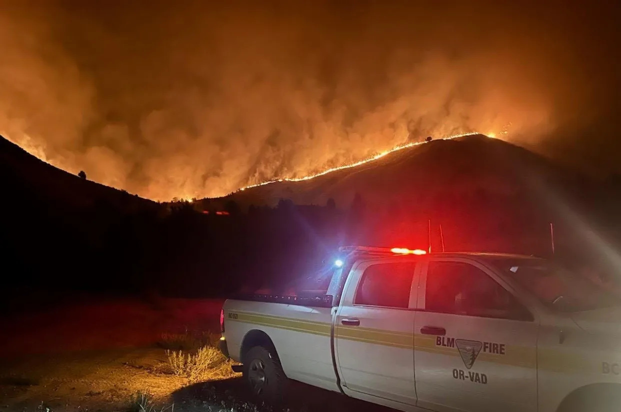
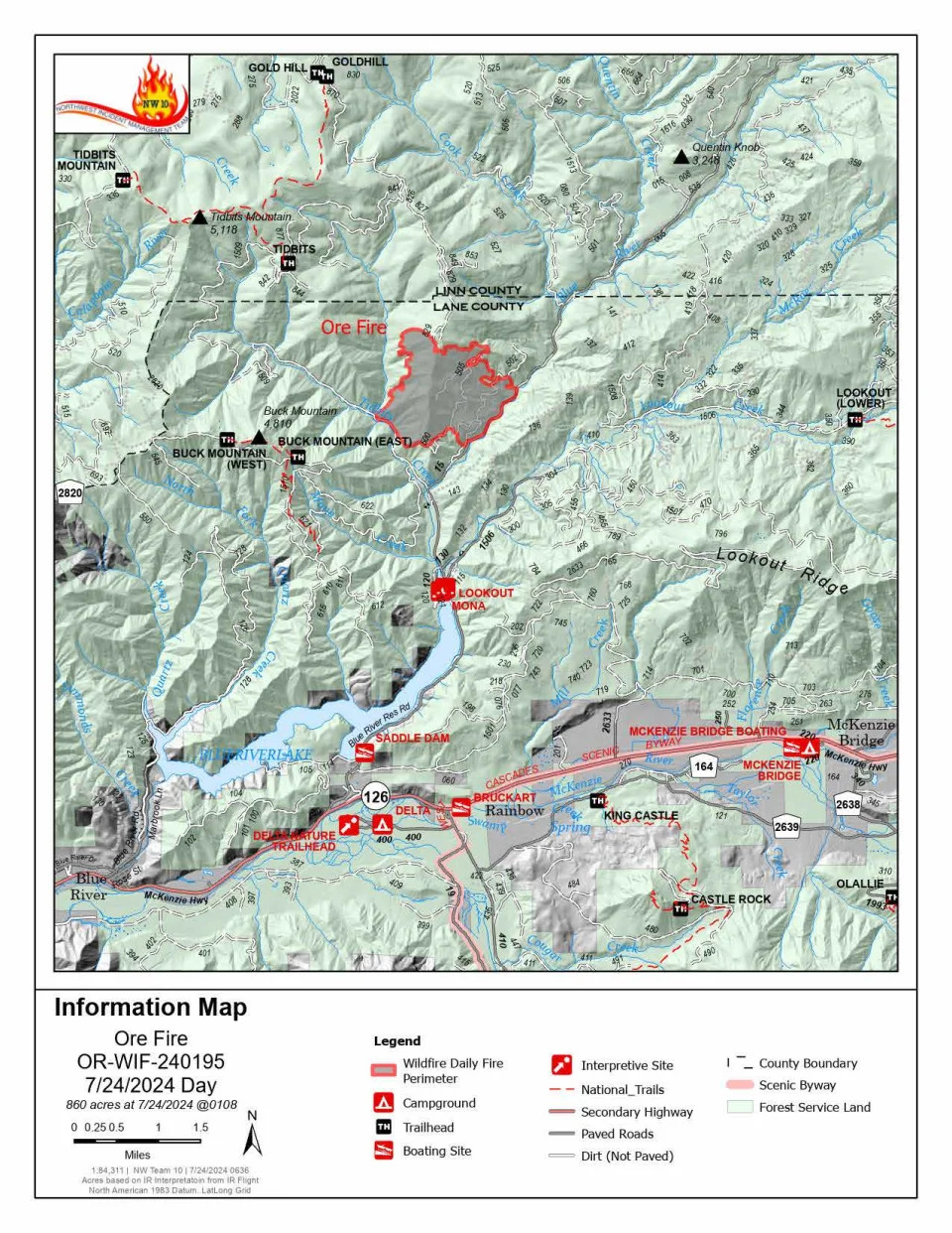
Ore Fire continues to grow amid rugged conditions and extreme fire behavior
Ore Fire information map.
The Ore Fire burning 7 miles northeast of Blue River was burning 860 acres as of Wednesday morning.
Fire managers are focusing on activities with the highest probability of success and least amount of risk to firefighters, communities and resources. The rugged and steep terrain, falling rocks, rolling debris, fire-weakened trees and extreme weather conditions continue to pose safety challenges for crews.
Burning debris rolling down steep slopes caused the fire to cross the established control line at FS 1509 Road on Tuesday. Firefighters were able to control the flames but falling debris will remain a challenge.
Buck Mountain Trail, Tidbits South and West Trail, Gold Hill Trail, Mona Campground, Lookout Campground and Saddle Dam Boat Launch are closed.
Other closures in the Willamette National Forest due to fire-impacted areas can be found at bit.ly/4dcWMCl
Homestead Complex reaches 910 acres
The Homestead Complex Fire, a group of fires in the Umpqua National Forest, had a combined 910 acreage total Wednesday morning.
The incident management teams assigned to the Homestead Complex and Diamond Complex will hold a joint community meeting at 5:30 p.m. on Wednesday in the Old Glide Middle School Gym.
On Tuesday, crews worked in both directions on the 258-acre the Horse Heaven Creek Fire, the most active in the complex, until fire activity intensified causing a switch to indirect tactics. Attempts at aviation intervention were thwarted due to thick smoke. Crews will try and build a containment line today, the news release said.
The steep and rugged terrain of the 267-acre No Man Fire makes it difficult to get firefighters on the ground near the fire’s edge. Crews will work to establish indirect control lines.
As of Wednesday, containment lines are being established for the 84-acre Reynolds Butte Fire and the 35-acre Lost Bucket Fire.
The 38-acre Fuller Lake Fire and 110-acre Bullpup Fire will remain unstaffed until resources become available.
The Umpqua National Forest issued closures for all of the Cottage Grove Ranger District and parts pf the Diamond Lake, North Umpqua and Tiller ranger districts. Boulder Flat Campground and Boat Launch are closed under the order.
BLM closes public lands due to wildfires southeast of Cottage Grove
Bureau of Land Management public lands southeast of Cottage Grove are closed due to wildfires in the areas of Sharps Creek and Clark Creek.
“The closure is for public and firefighter safety, and to allow fire suppression crews to continue to safely respond to the incident,” according to a Saturday news release from the BLM Northwest Oregon District.The closure area includes:
The Sharps Creek Campground and BLM-managed public lands southeast of the town of Dorena, surrounding Sharps Creek Road (County Road 2460 / BLM Road No. 23-1-12) and Clark Creek Road (BLM Road No. 23-1-13). It includes BLM lands in Township 22S, Range 1W, and Township 23S, Range 1W, Sections 1-3, 11-14, 22-24, 26-27, 33-34.
These areas are closed to the public and for activities including hiking, mining, hunting and camping.
BLM said Sharps Creek Road and Clark Creek Road are open to residents in the closure area.
Favorable weather helps crews fighting Microwave Tower Fire near Mosier
Crews were able to make progress by establishing lines on the east end of the 704-acre fire, as of Wednesday morning.
The fire has continued to creep down a north-facing ridge along I-84 and west of Mosier.
Authorities estimated 100 homes under level 3 and 500 residents were threatened in the Mosier area. Residents in Mosier west of the Columbia Gorge were being asked to evacuate due to the Microwave Tower Fire, which is being driven by strong winds.
Here are the evacuation levels for areas in Mosier related to the fire:
Level 3 “go now”: From Highway 30 south of Proctor Road, east to Huskey Road and the border of Mosier and west to the Hood River County line.
Level 2 “get set”: Mosier and from Huskey Road east to Mosier Creek Road and south to Jasper Lane.
Level 1 “be ready”: From Mosier Creek Road, east to Dry Creek Road, north to Mosier border and south to Osborn Cutoff Road.
There is a Red Cross shelter available for evacuees at Hood River Middle School, 1602 May St.,, Hood River, OR., 97031.
The fire started Monday afternoon west of Rattler Ridge west of Mosier.
The fire is burning in grass and timber and was being pushed eastwards by strong westerly winds.
“The fire has seen moderate activity with intermittent single tree torching, some flanking and smoldering creating a moderate amount of smoke,” according to a Wednesday update from the Oregon Department of Forestry. “The fire also saw growth backing down the north slope. With the expected increased winds today, crews are ready to address increased fire behavior. There is a potential for increased smoke in the area.”
20 fires burn at least 3,811 acres in the Diamond Complex
In the past 24 hours, 8 new fires at a combined 62 acres have been identified and added to the Diamond Complex on the Diamond Lake Ranger District of the Umpqua National Forest. The complex is 3% contained.
All fires are under a full suppression strategy with firefighters directly attacking the fire line where feasible.
These are the active fires in the complex:
Pine Bench: 1,472 acres (north of Highway 138 near Dry Creek)
Trail: 827 acres (east of Highway 138 on the west slope of Mount Thielsen)
Lemolo: 518 acres (north of Lemolo Lake on Bunker Hill)
Pig Iron: 27 acres (Pig Iron Mountain north of Highway 138)
Watson: 144 acres (north of Highway 138 on Watson Ridge)
Brodie: 95 acres (about 5 miles south of Highway 138 and south of Devils Canyon)
Trep: 101 acres (about 4 miles south of Highway 138)
Garwood: 5 acres (about 3 miles southwest of Mount Bailey)
Slide: 0.1 acres (northeast of Pine Bench)
Potter: 327 acres (north of Highway 138 about 2 miles southeast of Potter Mt.)
Ooya: 123 acres (north of Highway 138 about 1 mile northeast of Bird Point)
Clearwater: 7 acres (south of Highway 138 about 5 miles northwest of Diamond Lake)
Elephant: .07 acres (2 miles southwest of Lemolo Lake)
Lost Bear: 5 acres (2 miles south of Hwy 138)
Lost: 12 acres (4 miles south of Hwy 138)
The eight newest fires have not been named and are widely scattered in the area.
A level 2 “be set” evacuation warning was issued due to the Boulder Flat/Pine Bench Fire east of Roseburg and Glide in the North Umpqua Canyon near Toketee Falls. The evacuation was for homes in the Slide Creek area downstream to the Soda Springs area due to a fire near Soda Springs and Pine Bench in Toketee. A map of the evacuation area can be found here: bit.ly/4dc3qsB.
The weather on Tuesday was forecast to be lower in relative humidity and slightly higher in temperature. The conditions will support increased fire spread and spotting potential. This will add to the challenging fire behavior due to rugged and steep terrain.
Lemolo Fire reaches 404 acres in Douglas County
The Lemolo Fire in Douglas County had reach 423 acres as of Wednesday morning and was 0% contained.
The Douglas County Sheriff’s Office on Saturday night issued level 3 “go now” and level 2 “be ready” evacuation orders for the Lemolo Fire. The fire was reported to be at least 373 acres as of Sunday night.
Level 3 evacuations were issued for:
Bunker Hill Campground
Kelsay Valley Campground
The North Umpqua Trail between USFS 2612 Road and Windigo Pass intersection, west to North Umpqua Trail as it intersects with USFS 2612 Road.
This includes all areas on north and northeast side of Lemolo Lake, according to the sheriff’s office.
Level 2 evacuation orders have been issued for:
East Lemolo Campground
USFS 2614 Road south of Inlet Campground, including Kelsay Valley, Pumice Flat and Elbow Butte areas.
Falls Fire reaches 140,422 acres and 50% containment in Grant and Harney counties
The Falls Fire burning in Grant and Harney counties near Burns was 140,422 acres and was 50% contained as of Wednesday morning.
A cold front bringing wind and thunderstorms is anticipated to hit the Falls Fire area on Wednesday evening.
The fire was reported to be active on Monday afternoon due to southwest winds, which prompted growth along parts of the northern perimeter of the fire, according to the Tuesday morning update.
On Tuesday, Oregon State Fire Marshal crews were set to remain active on the northeast, east and southern parts of the fire.
The Oregon State Fire Marshal requested help from California to protect life and property against the fire on Friday.
The California Governor’s Office of Emergency Services provided three strike teams with 15 fire engines and 80 firefighters from nine different counties to provide structural protection.
Level 1, 2 and 3 evacuation orders remained in place in Grant and Harney counties. The Harney County Sheriff’s evacuation map can be found at bit.ly/4d1XvX2 for the most accurate evacuation notices.
Ten residences and 13 “other” structures were destroyed in the early stages of the fire, according to Oregon State Fire Marshal structure teams.
Round Mountain, Wickiup fires burn in Central Oregon
The Round Mountain and Wickiup fires on Deschutes National Forest remained at a combined 276 acres as of Tuesday morning. The Wickiup Fire is now 50% contained and Round Mountain is at 20%.
Crews were set to continue mop up for hot spots and secure the perimeter for both fires on Tuesday.
Campfires prohibited on BLM public lands in Northwest Oregon District
Campfires are now prohibited on all Bureau of Land Management public lands throughout the Northwest Oregon District.
Fires, campfires, smoking in vegetated areas, using vehicles in unmanaged vegetated areas, operating a chainsaw, welding, cutting or grinding, or using an internal combustion engine without a spark arrestor will be prohibited. The BLM announced Monday these stronger restrictions will remain in effect until rescinded.
More information on restrictions and closures can be found at blm.gov/orwafire
Fire restrictions in place for Willamette and Siuslaw national forests, majority of places in Oregon
The majority of Oregon’s national and state forests outlawed campfires, except in campgrounds.
Willamette National Forest and Siuslaw national forests, to the east and west of the Willamette Valley, implemented fire restrictions this week.
Fire restrictions prohibit all campfires, charcoal or briquette fires, pellet fires or other open fires outside of designated campgrounds. Building, maintaining or using a fire, campfire or stove was still permitted in designated metal campfire rings or grills in designated recreational sites.
Restrictions for smoking, off-highway vehicles and chainsaws in campgrounds were also in effect.
Now, research highlights a discovery that could pave the way for a new class of weight loss medications—and it’s linked to how your body responds to exercise. Here’s what the study discovered, plus what it could mean for the future of drugs like Ozempic.
Meet the expert: Mir Ali, MD, a bariatric surgeon and medical director of MemorialCare Surgical Weight Loss Center at Orange Coast Medical Center in Fountain Valley, California.
What did the study find?
The study, which was published in June in the journal Molecular Metabolism, analyzed mouse and human models to explore how the protein PGC-1α impacts exercise and its effects on the body. In case you’re not familiar with it (and why would you be?), PGC-1α is a protein that is involved in several processes in the body, including thermogenesis. Thermogenesis works to help your body efficiently consume energy in your muscles.
When you work out, more PGC-1α is expressed in your muscles and more energy is burned. But people who lose weight slowly when they do regular physical activity may be missing variants of PGC-1α that regulate the body’s metabolism and response to short-term exercise.
By targeting this protein, scientists think they can essentially help to rev up your metabolism. The researchers concluded in the study that increasing how much PGC-1α is expressed is “pivotal” for burning more energy and “essential” for regulating metabolism.
What does this study mean for fitness?
At this point, it’s hard to say. The scientists just discovered that it could be helpful to target this protein for weight loss, but the details and kinks of this haven’t been worked out just yet.
But it’s possible that people who already burn fat efficiently with the help of exercise wouldn’t be helped by a medication that targets PGC-1α, says Mir Ali, MD, a bariatric surgeon and medical director of MemorialCare Surgical Weight Loss Center at Orange Coast Medical Center in Fountain Valley, California. Still, it’s super early on in the process, making it tough to determine for sure.
What does this mean for weight loss drugs?
It’s not clear at this point. Again, this is in very early stages and there’s a lot that still needs to be explored. However, there is a chance that this could lead to a new class of weight loss drugs, giving people with overweight and obesity more options, Ali says.
Right now, Ali sees this as a potential additional tool to help with weight loss versus the only tool someone would use.
“The majority of weight loss is because of diet,” he says. “Exercise has a number of benefits, including enhanced weight loss, and it can improve cardiovascular health.”
It’s easy to forget about the risk of heat exhaustion or sunstroke when you’re enjoying a pool party or hanging out at the beach, but these serious conditions can and do happen. Ahead, three emergency room physicians answer questions about how to stay safe when it’s scorching out — from being able to identify symptoms to the most effective ways to keep cool.
Why should I care about heat illness now?
Summer is when temperatures are the highest in the U.S. As temperatures soared last year, so did ER visits for heat illness. A study from the Centers for Disease Control and Prevention published in April found that there were nearly 120,000 heat-related emergency room visits in 2023, and 90% of them happened between May and September.The most ER visits happened in Arkansas, Louisiana, New Mexico, Oklahoma and Texas, with males and adults between the ages of 18 and 64 having the highest rates of ER visits for heat illness.
Heat is also the deadliest form of extreme weather, the National Weather Service warns. Hot weather kills 1,220 people annually, according to the CDC. And tolls are rising each year, amid climate change. Last year was the hottest in human history, and a record-breaking 2,303 people died from heat exposure, the Department of Health and Human Services estimates.
“With hotter summer months rapidly approaching, it’s important to plan ahead to protect yourself and others from heat illness,” Dr. Marc Taub, an emergency physician and medical director of emergency services at MemorialCare Saddleback Medical Center in Laguna Hills, Calif., tells Yahoo Life. “It’s especially important to take precautions for those who are more vulnerable to the heat, such as children, older adults, pregnant persons, those who work outdoors, people without ready access to cool areas and fluids and people with underlying health conditions.”
Heat illness (also known as heat-related illness) is an umbrella term used to describe several conditions that can happen to your body when temperatures rise.
Heat illness generally refers to these conditions:
Heat cramps: These can be the first sign of heat illness, and usually involve painful muscle cramps that can happen in the legs and abdomen, per the National Weather Service (NWS).
Heat exhaustion: Heat exhaustion is the body’s response to an excessive loss of water and salt that usually happens from sweating a lot, according to the CDC. It can cause heavy sweating, fatigue and dizziness, along with other symptoms.
Heat stroke: Also known as sunstroke, this is the most serious heat illness, the CDC says. It happens when the body can no longer control its temperature. The sweating mechanism fails, and the body is no longer able to cool down. Body temperature can also get to 106 degrees or higher within 10 to 15 minutes, according to the CDC. Heat stroke can lead to permanent disability or death.
Symptoms of heat illness vary depending on the type you experience. Here’s a breakdown, according to the CDC:
Heat cramps
Muscle cramps in the abdomen, arms or legs
Pain in the abdomen, arms or legs
Spasms in the abdomen, arms or legs
Heat rash
Red clusters of pimples or small blisters
Pimples or blisters that show up on the neck, upper chest, groin, under the breasts and in elbow creases
Heat exhaustion
Headache
Nausea
Dizziness
Weakness
Irritability
Thirst
Heavy sweating
Elevated body temperature
Urinating less than usual
Heat stroke
Confusion, altered mental status, slurred speech
Loss of consciousness
Hot, dry skin or excessive sweating
Seizures
Very high body temperature
How dangerous is heat illness?
It depends on the type of heat illness you have. Heat rash and heat cramps are “generally uncomfortable if you are healthy,” Dr. Lewis Nelson, chair of emergency medicine at Rutgers New Jersey Medical School, tells Yahoo Life. However, they are not usually serious.
But anyone can experience heat exhaustion and heat stroke — the latter of which is life-threatening, he points out.
“With heat stroke, you can develop organ problems, kidney failure, heart problems and stroke-like symptoms,” Dr. Eric Adkins, emergency medicine physician at The Ohio State University Wexner Medical Center, tells Yahoo Life. “You can die from heat stroke.”
I am having symptoms. What should I do?
Doctors recommend getting out of the heat ASAP if you don’t feel well. “The most important intervention if you feel sick in the heat is to move to a cooler area,” Nelson says. “This may be as simple as moving out of the sun or going indoors.”
Using a fan can speed up the evaporation of sweat and help you cool down, but Nelson points out that it’s “not very efficient” at higher temperatures. In fact, the Environmental Protection Agency recommends that people don’t use fans when the heat index temperature, which is a combination of the temperature and humidity, is above 99 degrees Fahrenheit.
“Making sure you are adequately hydrated is critical and replacing the lost sweat with water, plus electrolytes will help avoid a fall in your blood sodium level,” Nelson says.
It’s also a good idea to take off extra clothes and put on wet towels, if you have them nearby, to help cool you down, Adkins says. Spraying water on your body can also help, according to Taub.
If someone is showing symptoms of heat stroke, call 911 immediately. The NWS also urges getting “immediate medical attention” if heat cramps last for more than an hour, the person vomits or if heat exhaustion symptoms get worse or last for more than an hour.
How can I stay informed about heat risks?
The CDC just launched a Heat & Health Tracker to make it easier to know what’s happening with heat in your area. The tracker offers local heat and health information, including rates of emergency room visits for heat illness where you live. The CDC also notes which medications might make you more vulnerable to the effects of heat, and how to store them safely when temperatures rise.
“Keep track of daily weather forecasts and local heat alerts,” Taub says. “Good sources of information on current and forecasted weather include local news channels and weather websites.” He also suggests checking out Heat.gov for up-to-date information and forecasts.
My car is always sizzling in the summer. How can I keep myself cool?
Car temperatures can skyrocket, and research has found that interior temperatures can hit 116 degrees and seats can get up to 123 degrees.
“Getting into a hot car for a brief period of time is generally safe, but opening the windows or turning on the air conditioning should help moderate the temperature,” Nelson says. “The inside of a car, especially in the sun, can reach unsafe temperatures if not cooled, so do not keep children or pets in closed cars, even if out of the sun.”
Adkins recommends parking in the shade when you can. A sun shade in your car can help to deflect heat away from the interior as well, Taub says. If your car doesn’t have air conditioning and it’s extremely hot outside, Adkins suggests taking public transportation if it’s available.
What are the most effective ways to stay cool?
If you feel yourself getting hot, there are a few things you can do to cool off in the moment.
Drinking plenty of water is an obvious choice, but Adkins also recommends keeping an eye on the color of your urine. “If it looks more pale yellow, you’re hydrated,” he says. “If it’s dark yellow, orange or brown, that’s a primary sign of dehydration.”
Using fans, including portable fans, when the heat index is below 99 degrees can be helpful, along with misting yourself with cool water, Nelson says. Putting cool, wet cloths on your wrists, neck and ankles can help keep your temperature down, too, Adkins says.
Is there anything else I can do?
Doctors say there are a few other moves you can make to keep yourself cool on hot days. A big one is avoiding being outside on the hottest times of the day — typically between 10 a.m. and 2 p.m. — if you’re able, Adkins says.
Nelson also suggests carrying around a bottle of water with you to make sure you’re staying well hydrated. Carrying a portable fan in your bag and using it when you need to cool off can also be helpful, according to Adkins.
If you want to really plan ahead, Adkins recommends planting trees on your property to create shade for the future.
Overall, doctors stress the importance of being aware of the heat in your area and taking steps to keep yourself cool. “Exposure to excess heat can be serious — and it’s important to take it seriously,” Adkins says.
This article was originally published on May 22, 2024 and has been updated.
Things to know about dangerous rip currents and how swimmers caught in one can escape
Curt Anderson – June 24, 2024
This image provided by NOAA, pictures a harmless green dye used to show a rip current. Rip currents are powerful, narrow channels of fast-moving water that are prevalent along the East, Gulf, and West coasts of the U.S., as well as along the shores of the Great Lakes. About 100 people drown from rip currents along U.S. beaches each year, according to the U.S. Lifesaving Association. (NOAA via AP)A no swimming flag is visible as waves crash against the rocks at Haulover Beach Park, November 18, 2020, in Miami Beach, Florida. About 100 people drown from rip currents along U.S. beaches each year, according to the U.S. Lifesaving Association, and more than 80 percent of beach rescues annually involve rip currents. (David Santiago/Miami Herald via AP, File)Beachgoers walk past warning flags and signs, Jan. 13, 2020, in Pompano Beach, Fla. About 100 people drown from rip currents along U.S. beaches each year, according to the U.S. Lifesaving Association, and more than 80 percent of beach rescues annually involve rip currents. (Joe Cavaretta/South Florida Sun-Sentinel via AP, File)
ST. PETERSBURG, Fla. (AP) — Stinging jellyfish, rays with their whip-like tails and sharks on the hunt are some ocean hazards that might typically worry beachgoers. But rip currents are the greatest danger and account for the most beach rescues every year.
About 100 people drown from rip currents along U.S. beaches each year, according to the United States Lifesaving Association. And more than 80 percent of beach rescues annually involve rip currents.
The National Weather Service lists 16 known deaths so far in 2024 from rip currents in U.S. waters, including the Florida fatalities as well as eight deaths in Puerto Rico and two in Texas.
Here are some things to know about rip currents:
What is a rip current?
Rip currents are narrow columns of water flowing rapidly away from the beach, like a swift stream within the ocean. They don’t pull swimmers under water, but can carry them out a fair distance from shore.
Low spots along the beach, or areas near jetties or piers, are often where rip currents form. They can be connected to stormy weather but also sometimes occur during sunny days. They can be hard to detect because the surface water often appears calm.
The current can flow as swiftly as eight feet per second (3.2 meters per second), faster than even a strong swimmer can overcome, according to the National Oceanic and Atmospheric Administration.
“If you’re caught in one and you try to swim straight in, you’re not going to be able to,” said Daniel Barnickel of Palm Beach County Ocean Rescue.
How can someone escape a rip current?
The most frequent advice from beach rescue teams and weather forecasters is to not panic and look for a chance to swim parallel to the shore until the swimmer is out of the rip current’s grip. It will eventually dissipate but might leave the swimmer out in deeper water.
It’s nearly impossible to fight the current directly. Many swimmers who get in trouble tire themselves out trying to get back to the beach, lifeguards say. If possible, it’s best to swim near a lifeguard station.
“Most of our rip current rescues happen outside the guarded areas because we’re not there to prevent it from happening,” Barnickel said.
What warning systems exist for rip currents?
Flags with different colors are used to warn beachgoers of various hazards.
Three flags warn of surf and rip current conditions. Red means a high hazard, yellow means a moderate threat and green means low danger. There’s also purple for dangerous sea life, like jellyfish, and double red when a beach is closed for any reason.
The National Weather Service posts rip current risks on its websites around the coasts and has developed a computer model that can predict when conditions are favorable for their formation up to six days in advance for the U.S. East and Gulf Coasts, Puerto Rico, Hawaii and Guam.
“Before this, forecasters were manually predicting rip currents on a large section of the ocean twice a day and only a day or two into the future. The earlier prediction has potential to substantially increase awareness and reduce drownings,” said Gregory Dusek, a NOAA scientist who developed the model, in a post on the agency’s website.
High risk warnings were posted for most Florida beaches last week, when the drownings occurred.
Should someone attempt a rip current rescue?
It can be dangerous to try to rescue someone caught in a rip current, officials say. Often the people trying to perform the rescue can get into trouble themselves.
It’s best to find a lifeguard, if there is one, or call 911 if a struggling swimmer is spotted. People on shore can also try to tell the person to swim parallel to shore.
“Never swim alone. And always make sure that there’s an adult. And make sure that you don’t overestimate your abilities. Know your limits,” Barnickel said.
Associated Press video journalist Cody Jackson in Palm Beach contributed to this story.
Extreme heat kills hundreds, millions more sweltering worldwide as summer begins
Gloria Dickie – June 20, 2024
LONDON (Reuters) -Deadly heatwaves are scorching cities on four continents as the Northern Hemisphere marks the first day of summer, a sign that climate change may again help to fuel record-breaking heat that could surpass last summer as the warmest in 2,000 years.
Record temperatures in recent days are suspected to have caused hundreds, if not thousands, of deaths across Asia and Europe.
In Saudi Arabia, nearly two million Muslim pilgrims are finishing the haj at the Grand Mosque in Mecca this week. But hundreds have died during the journey amid temperatures above 51 degrees Celsius (124 degrees Fahrenheit), according to reports from foreign authorities.
Egyptian medical and security sources told Reuters on Thursday that at least 530 Egyptians had died while participating – up from 307 reported as of yesterday. Another 40 remain missing.
Countries around the Mediterranean have also endured another week of blistering high temperatures that have contributed to forest fires from Portugal to Greece and along the northern coast of Africa in Algeria, according to the U.S. National Oceanic and Atmospheric Administration’s Earth Observatory.
In Serbia, meteorologists forecast temperatures of around 40 C (104 F) this week as winds from North Africa propelled a hot front across the Balkans. Health authorities declared a red weather alert and advised people not to venture outdoors.
Belgrade’s emergency service said its doctors intervened 109 times overnight to treat people with heart and chronic health conditions.
In neighbouring Montenegro, where health authorities also warned people to stay in the shade until late afternoon, tens of thousands of tourists sought refreshment on the beaches along its Adriatic coast.
Europe this year has been contending with a spate of dead and missing tourists amid dangerous heat. A 55-year-old American was found dead on the Greek island of Mathraki, police said on Monday – the third such tourist death in a week.
A broad swath of the eastern U.S. was also wilting for a fourth consecutive day under a heat dome, a phenomenon that occurs when a strong, high-pressure system traps hot air over a region, preventing cool air from getting in and causing ground temperatures to remain high.
New York City opened emergency cooling centres in libraries, senior centers and other facilities. While the city’s schools were operating normally, a number of districts in the surrounding suburbs sent students home early to avoid the heat.
Meteorological authorities also issued an excessive heat warning for parts of the U.S. state of Arizona, including Phoenix, on Thursday, with temperatures expected to reach 45.5 C (114 F).
In the nearby state of New Mexico, a pair of fast-moving wildfires abetted by the blistering heat have killed two people, burned more than 23,000 acres and destroyed 500 homes, according to authorities. Heavy rains could help temper the blazes, but thunderstorms on Thursday were also causing flash flooding and complicating firefighting efforts.
All told, nearly 100 million Americans were under extreme heat advisories, watches and warnings on Thursday, according to the federal government’s National Integrated Heat Health Information System.
The brutal temperatures should begin easing in New England on Friday, the weather service said, but New York and the mid-Atlantic states will continue to endure near-record heat into the weekend.
COUNTING THE DEAD
India’s summer period lasts from March to May, when monsoons begin slowly sweeping across the country and breaking the heat.
But New Delhi on Wednesday registered its warmest night in at least 55 years, with India’s Safdarjung Observatory reporting a temperature of 35.2 C (95.4 F) at 1 a.m.
Temperatures normally drop at night, but scientists say climate change is causing nighttime temperatures to rise. In many parts of the world, nights are warming faster than days, according to a 2020 study by the University of Exeter.
New Delhi has clocked 38 consecutive days with maximum temperatures at or above 40 C (104 F) since May 14, according to weather department data.
An official at the Indian health ministry said on Wednesday there were more than 40,000 suspected heatstroke cases and at least 110 confirmed deaths between March 1 and June 18, when northwest and eastern India recorded twice the usual number of heatwave days in one of the country’s longest such spells.
Gaining accurate death tolls from heatwaves, however, is difficult. Most health authorities do not attribute deaths to heat, but rather the illnesses exacerbated by high temperatures, such as cardiovascular issues. Authorities therefore undercount heat-related deaths by a significant margin – typically overlooking thousands if not tens of thousands of deaths.
RECORD WARM TEMPERATURES
The heatwaves are occurring against a backdrop of 12 consecutive months that have ranked as the warmest on record in year-on-year comparisons, according to the European Union’s climate change monitoring service.
The World Meteorological Organization says there is an 86% percent chance that one of the next five years will eclipse 2023 to become the warmest on record.
While overall global temperatures have risen by nearly 1.3 C (2.3 F) above pre-industrial levels, climate change is fuelling more extreme temperature peaks – making heatwaves more common, more intense and longer-lasting.
On average globally, a heatwave that would have occurred once in 10 years in the pre-industrial climate will now occur 2.8 times over 10 years, and it will be 1.2 C warmer, according to an international team of scientists with the World Weather Attribution (WWA) group.
Scientists say heatwaves will continue to intensify if the world continues to unleash climate-warming emissions from the burning of fossil fuels.
If the world hits 2 C (3.6 F) of global warming, heatwaves would on average occur 5.6 times in 10 years and be 2.6 C (4.7 F) hotter, according to the WWA.
(Reporting by Gloria Dickie in London; additional reporting by Aleksandar Vasovic in Belgrade, Pesha Magid in Riyadh, Shivam Patel in Delhi, Ahmed Mohamed Hassan in Cairo, Ali Withers in Copenhagen and Joseph Ax in New York; editing by Mark Heinrich and Josie Kao)