Climate change has doubled the chance of a California megaflood: Study
Ben Adler, Senior Editor– August 16, 2022
California is already known for being vulnerable to natural disasters such as earthquakes, wildfires and even tsunamis, but a new study in the journal Science Advances finds that it is at increased risk of another: a disastrous megaflood that could cause more than $1 trillion in losses and turn low-lying areas into a “vast inland sea.”
The Golden State is currently enduring the worst 20-year drought in at least 1,200 years — an event made more likely due to climate change, as warmer air causes more evaporation. But, the study’s authors note, “Despite the recent prevalence of severe drought, California faces a broadly underappreciated risk of severe floods.”
Just as increased evaporation causes more frequent and severe droughts, it also causes more extreme rainfall when a storm arrives. The paper finds that climate change has doubled the chances of a dramatic flood in California during the next 40 years, and that the risk will continue to increase if average global temperatures keep rising.
Low water levels at Grant Lake, which is fed by now nearly snowless mountains in the Eastern Sierra Nevada, expose an expanded shoreline on Aug. 11 near Lee Vining, Calif. (David McNew/Getty Images)
The researchers used new high-resolution weather modeling and existing climate models to find how often a long series of storms fueled by atmospheric rivers that have occurred about once a century in recent history would occur, now that global average temperatures have risen 1.1 degree Celsius (2 degrees Fahrenheit) since the Industrial Revolution. What they found was that warmer temperatures have doubled the risk of those conditions, so that what was once a 1-in-100-year flood would now occur every 50 years, on average.
“Climate change has probably already doubled the risk of an extremely severe storm sequence in California, like the one in the study,” Daniel Swain, a climate scientist at the University of California, Los Angeles, who co-authored the study with Xingying Huang, a climate scientist at the National Center for Atmospheric Research, told NPR. “But each additional degree of warming is going to further increase that risk.”
An atmospheric river is a long, narrow band of heavy moisture. Historically, winter atmospheric rivers have led to large snowfalls in the Sierra Nevada mountains. In a warmer climate, however, atmospheric rivers will be stronger because they hold more moisture. With warmer temperatures, more of the precipitation will fall as rain, causing flooding, instead of snow, which melts gradually.
In recent history, the only example of such a flood is the Great Flood of 1862. In December 1861, nearly 15 feet of snow fell in the Sierra Nevada mountain range, and subsequent atmospheric rivers dumped rain for 43 days after that, with the water pooling in valleys. This meant that in the winter of 1862, parts of California were submerged in up to 30 feet of water for weeks, according to CNN. The state capital in Sacramento, “was under 10 feet of debris-filled water for months.”
A lithograph showing K Street in the city of Sacramento, Calif., during the Great Flood of 1862. (A. Rosenfield/WikiCommons)
Buildings were destroyed, including one out of every eight homes, and 4,000 people died. The state lost one-quarter of its economy that year.
No flood that large has happened since then, but river sediment deposits show that in the pre-climate change era, such floods usually happened every 100 to 200 years.
“We find that climate change has already increased the risk of a [1862-like] megaflood scenario in California, but that future climate warming will likely bring about even sharper risk increases,” the study’s authors write.
“It’s a question of when rather than if [the megaflood] occurs,” Swain told CNN.
But the effects would be far worse, now that California has grown to 39 million residents, with an economy that, if it were a country, would be the world’s fifth-largest.
According to the researchers’ modeling, Stockton, Fresno and Los Angeles would be under water and damages could be upward of $1 trillion, potentially the most expensive disaster in world history. Interstate highways in California, such as I-5 and I-80, would probably be shut down for weeks.
A man kayaks down a flooded street in the town of Guerneville, Calif., on Feb. 28, 2019, thanks to floodwaters from the Russian River nearby. (Josh Edelson/AP)
“Every major population center in California would get hit at once — probably parts of Nevada and other adjacent states, too,” Swain said in a UCLA press release.
The increased risk of extreme rainfall due to climate change is not limited to California or the West Coast. The United States recently experienced three extreme rainfalls of the kind that were supposed to only occur once in every 1,000 years: southern Illinois received 12 inches of rain in 12 hours, the St. Louis area 6 to 10 inches of rain in just seven hours, and parts of eastern Kentucky were drenched by 14 inches of rain in two days.
The California Department of Water Resources supported the study with data and funding, as part of an effort to understand and prepare for extreme weather risks exacerbated by climate change. Further research — which will include partnering with state and federal emergency management agencies — will try to determine where the flooding would be worst and how it could be mitigated.
“Modeling extreme weather behavior is crucial to helping all communities understand flood risk even during periods of drought like the one we’re experiencing right now,” Karla Nemeth, director of the California Department of Water Resources, said in a statement.
Arizona loses one-fifth of its Colorado River allocation under new federal drought plan
Debra Utacia Krol, Arizona Republic – August 16, 2022
The federal government will impose deeper cuts on the drought-stricken Colorado River, officials said on Tuesday, reducing water deliveries to Arizona by one-fifth starting in January.
The Bureau of Reclamation announced what it called “urgent action” as water levels in the river’s two largest reservoirs continue to drop. Under the steps outlined Tuesday, Arizona will lose 592,000 acre-feet of its river allocation in 2023, which represents 21% of its usual delivery. That’s an increase of 80,000 acre-feet from the 2022 cuts.
The additional cuts will come from the non-Indian agricultural water allocations, which includes farmers and some tribes, said Arizona Department of Water Resources Director Tom Buschatzke.
Nevada will give up 25,000 acre-feet, about 8% of its allocation, and Mexico’s share will be cut by 104,000 acre-feet, or 7% of its allocation. California will not lose any of its share under the blueprint released Tuesday.
These moves are meant to protect two major dams from structural damage and the ability to generate electric power.
Currently, Lake Mead holds just over 25% capacity and Lake Powell just less than 25%.
“Prolonged drought is one of the most profound issues facing the U.S. today,” said Tommy Beaudreau, assistant Interior secretary.
The Bureau of Reclamation also said it would take immediate action to address the continuing shortfalls in the system. Some of those include reducing Glen Canyon Dam releases to below 7 million acre-feet per year to protect critical infrastructure; investing in conservation and voluntary agreements; and looking closely at Lake Mead operations to prevent the reservoir from falling to critically low levels.
Federal officials said the Inflation Reduction Act, signed into law by President Joe Biden on Tuesday, allocates $4 billion to the Bureau of Reclamation for drought relief and $12.5 million for emergency drought funding for tribes.
The measure also allocates $550 million for water programs in disadvantaged communities. That’s in addition to $8.3 billion the bureau received to address drought and build water systems under the Bipartisan Infrastructure Act.
Interior Department officials said they would continue dialogue with the 30 federally recognized tribes in the basin and with Mexico as well as with the seven basin states to jointly deal with the long-term shortages.
Arizona: Proposed cuts are ‘unacceptable’
This chart shows the key water levels in Lake Mead, which is used to determine water deliveries for Arizona, Nevada and California.
Arizona’s water managers suggested the plan was not enough and put too much of the burden on the Central Arizona Project, despite calls from the federal government to reduce water consumption across the river basin.
“It is unacceptable for Arizona to continue to carry a disproportionate burden of reductions for the benefit of others who have not contributed,” read a statement by Buschatzke and Ted Cooke, general manager of the CAP.
They said a proposal put forth by Arizona was rejected.
Federal officials acknowledged the urgency of the situation.
“Our reservoirs are declining rapidly,” said Tanya Trujillo, assistant secretary of the Interior Department for water and science.
She said all users have the responsibility to ensure the water is used responsibly. Trujillo said if new funding is authorized without prompt actions now, the Colorado River and the 40 million people who depend on it will face an uncertain future.
Arizona already has taken significant cuts to its annual take from the river, but it hasn’t been enough to keep Lake Mead from dropping further.
Under a set of guidelines negotiated between the states and the Bureau of Reclamation, the Central Arizona Project reduced its pumping by 512,000 acre-feet this year after the bureau officially declared a shortage base on reservoir projections released a year ago.
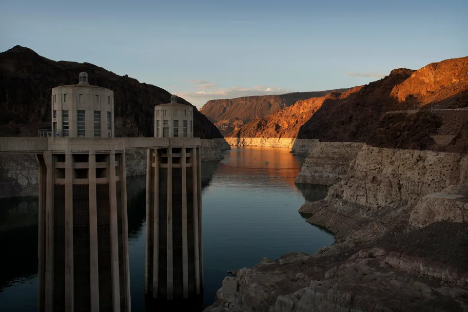
A bathtub ring of light minerals shows the high water line of Lake Mead near water intakes on the Arizona side of Hoover Dam at the Lake Mead National Recreation Area on June 26, 2022, near Boulder City, Nevada. The reservoir is now below 30% of capacity, Its level has dropped 170 feet since reaching a high-water mark in 1983.
That would be enough to supply about 1.5 million Arizona households if it went exclusively to municipal uses.
The next tier, triggered when Lake Mead is projected to drop below elevation 1,050 feet above sea level, requires another 80,000 acre-feet from Arizona under guidelines adopted in 2007.
With a previously enacted Drought Contingency Plan and an additional emergency commitment that Arizona made with California and Nevada last winter, the state’s total reductions in 2022 total about 800,000 acre-feet, or more than a quarter of the state’s Colorado River allocation, according to CAP.
When disappointing runoff from Rocky Mountain snowpack started flowing toward reservoirs this spring and early summer, the Bureau of Reclamation said it would require more, at least 2 million and maybe 4 million acre-feet from all users in the watershed. That set off a scramble among Arizona and its neighbors to find more water.
Sharon Megdal, director of the University of Arizona’s Water Resources Research Center, said the numbers don’t work if all of the states aren’t involved.
“Even if CAP and the cities were totally cut off, that wouldn’t add up to 4 million acre-feet,” she said. Cutting water use should be discussed and agreed to by all sectors and states, including the Upper Basin. “Nobody will come out of this unscathed.”
Residential water users are likely to escape the effects because most cities deliver water from a mix of sources. Phoenix implemented its drought management plan June 6 when it issued a Stage 1 water alert, asking residents to voluntarily conserve water use. Although the Colorado River provides about 40% of the city’s water, residential water users are unlikely to experience any cuts at this time.
But one major water stakeholder said Tuesday it had reassessed its position. The Gila River Indian Community cited a lack of progress among the states in its decision to stop contributing water to help shore up Lake Mead’s water levels.
Gila River Gov. Stephen Roe Lewis said Tuesday the tribe would go another direction.
“The community has been shocked and disappointed to see the complete lack of progress in reaching the kind of cooperative basin-wide plan necessary to save the Colorado River system,” Lewis said. The tribe reevaluated its strategy and will instead return to storing water underground.
The Colorado River Indian Tribes contributed more than 200,000 acre-feet and fallowed farmland. The tribe said its actions raised Lake Mead’s level by 3 feet. The 4,270-member tribe plans to up its contribution in 2023 and to develop more ways to use less water, according to a statement.
“We recognize that the decades-long drought has reduced the water availability for all of us in the basin,” said CRIT Chairwoman Amelia Flores. “Our ancestors lived through droughts and floods before the settlers arrived and built the dams on the Colorado River. We are a resilient people at CRIT and bring this attitude to the way we live and to our efforts to protect the life of the river that is our namesake.”
Planners want more certainty
The Imperial Irrigation District, which holds 2.6 million acre-feet of Colorado River rights, issued a statement seeking more details from federal officials in conservation and reservoir operations at Lake Mead.
The Colorado River is the Imperial Valley’s only water source, according to the district. Its 116,000 acres of irrigated lands produce much of the nation’s vegetables during the winter months. One of the district’s big concerns is keeping the nearby Salton Sea from declining further while protecting their farms.
“By adopting this plan, we’re providing a means for Imperial Valley growers to be able to continue their work to meet the nation’s food supply needs, within IID’s available water supply, while supporting the river,” said James C. Hanks, the district’s board president.
The two major Arizona water agencies argued that other states must do their part in preserving the river.
“We can’t do this alone without California,” said Buschatzke. He said the Upper Basin plan is in its early stages with few details.
The seven basin states and tribes are negotiating new water management guidelines to replace the current guidelines, which expire at the end of 2025.
Cooke, the CAP general manager, said any discussion among basin states to take further reductions should take into account current reductions.
“We’re taking an almost 600,000 acre-feet cut, Nevada is losing 25,000 acre-feet and Mexico is taking a 100,000 acre-feet cut, but California is taking none,” he said. “We’re willing to do our part, but we can’t continue to be the ones who do the most.”
The two state officials said they want to see more long-term planning. They want planners looking at 2024 and beyond. Cooke said he hopes the 2023 plan in progress can have more durable elements so they don’t have to start at zero in subsequent years.
Buschatzke gave Reclamation a grade of “incomplete” in its plans. Then-Interior Secretary Gale Norton had to give the states a nudge, a “kick in the pants,” to complete a plan in the mid-2000s, he said.
Nevada: Take concrete steps
U.S. Sen. Kyrsten Sinema, D-Ariz., agreed with state water officials.
“As the West continues experiencing historic drought, Arizona has led the way identifying short and long term solutions while shouldering a disproportionate share of this crisis,” she said.
Sinema created a water advisory council earlier this month to discuss how to expend the $4 billion earmarked for drought and water programs.
U.S. Sen. Mark Kelly, D-Ariz., said in a letter to Interior Secretary Deb Haaland that the Bipartisan Infrastructure Law also contained funding to support voluntary reductions.
Megdal, of the UA, said that the new funding is welcome; however, she said, nothing she learned about the new measures means the pressure is off. “We all need to work together.”
The Southern Nevada Water Authority, which oversees water for metropolitan Las Vegas, echoed the comments made by Arizona officials.
“The Colorado River cannot provide enough water for the current level of use,” said John Entsminger, the authority’s general manager. “The magnitude of the problem is so large that every single water user in every single sector must contribute solutions to this problem regardless of the priority system.”
Entsminger suggested several actions, including eliminating wasteful and antiquated water use, and eliminating lawns. In June 2021, Nevada passed legislation that prohibits non-functional grass irrigated by Colorado River water. That covers about one-third of southern Nevada lawns.
U.S. Rep. Greg Stanton, D-Ariz., also expressed disappointment that the Interior Department had fallen short in its announcement.
“The federal government has failed to offer a plan that requires all states to make the cuts necessary to save the Colorado from system collapse,” Stanton said. “Today’s announcement merely kicks the can down the road and risks turning this crisis into catastrophe.”
Kelly also called for decisive action to develop long-term solutions to mitigating drought on the Colorado River, saying this “must be an urgent priority for the Department.”
One water activist called out a “vague” plan and asked what steps the bureau would take next if the seven basin states can’t or don’t reduce water usage.
“If you were hoping for security and knowing exactly what’s going to happen, Reclamation’s ‘plan’ doesn’t change much of anything,” said Gary Wockner, director of the environmental group Save the Colorado.
The group also proposed a possible solution to the issue, one that environmentalists have discussed for years: “We encourage Reclamation to focus quickly on how to drain Lake Powell and bypass Glen Canyon Dam because it is the weight that is driving this crisis and dragging the whole system down.”
Republic reporter Brandon Loomis contributed to this article.
Debra Krol reports on Indigenous communities at the confluence of climate, culture and commerce in Arizona and the Intermountain West.
Coverage of Indigenous issues at the intersection of climate, culture and commerce is supported by the Catena Foundation.
Map shows ‘extreme heat belt’ projected to cover a quarter of the US in 30 years, where temperatures would breach 125 degrees Fahrenheit
Morgan McFall-Johnsen – August 16, 2022
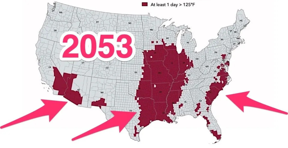
The US counties where First Street Foundation expects temperatures to exceed 125 degrees Fahrenheit at least one day in 2053.First Street Foundation
An “extreme heat belt” may form in the US by 2053, an analysis from First Street Foundation predicts.
The report used satellite data to model heat risk at the property level for the next 30 years.
Predictive maps show that 107 million Americans could see temperatures above 125 degrees Fahrenheit.
The heat waves scorching the US this summer may just be the beginning of an extreme heat belt forming across the country.
“If people think this was hot — this is going to be one of the better summers of the rest of their lives,” Matthew Eby, CEO of the climate-risk research nonprofit First Street Foundation, told Insider.
The foundation published a “Hazardous Heat” report on Monday, using a peer-reviewed model to assess six years of US government satellite data and predict future risk of extreme heat by property. Its conclusions align with scientists’ warnings that extreme heat will become more common, more extreme, and longer-lasting in the coming decades.
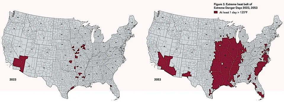
Next year, the report projects that 8 million Americans face the prospect of sweltering in at least 125 degrees Fahrenheit for at least one day. By 2053, that would rise to 107 million Americans — 13 times more people in just 30 years, according to the report.
That’s about one-third of the current population, covering one-quarter of the US land area, as shown in the map below.
Counties where at least one day is expected to breach 125 degrees Fahrenheit in 2023 (left) and 2053 (right).First Street Foundation
The majority of that extreme heat is expected in the center of the country, from the Texas and Louisiana Gulf Coast up through Chicago — an area that First Street Foundation is calling the “extreme heat belt.” Significant portions of the southwest and southeast are also likely to have more than one day above 125 degrees Fahrenheit in 2053, according to the report.
Gabe DeBay, Medical Services Officer with the Shoreline Fire Department, checks the blood pressure of a homeless man at a tent encampment during the hottest part of the day on July 26, 2022 in Shoreline, Washington.David Ryder/Getty Images
At such high temperatures, the National Weather Service warns that risk of heat stroke is high. Infrastructure often fails at such high temperatures, too. Roads buckle, train tracks bend and can cause derailing, and airport tarmacs can melt and prevent takeoff. Sometimes the power even goes out.
More hot days and more heat waves
Days that breach 125 degrees Fahrenheit aren’t the only ones to worry about. Even temperatures above 100 degrees can be dangerous. In another map, below, the report projects more days above 100 degrees across the southern half of the country.
Circles represent days above 100 degrees Fahrenheit in 2023 (left) and 2053 (right). Darker colors indicate a greater number of days, while the sizes of the circles represent the number of properties impacted.First Street Foundation
The extreme heat of the summer so far in 2020 lines up with many of the locations where First Street Foundation expects the most heat in years to come, Eby said.
For example, as the map below shows, the report projects more heat waves across the country, with significantly increased risk in northern areas including the Pacific Northwest, and other regions that aren’t historically accustomed to extreme heat.
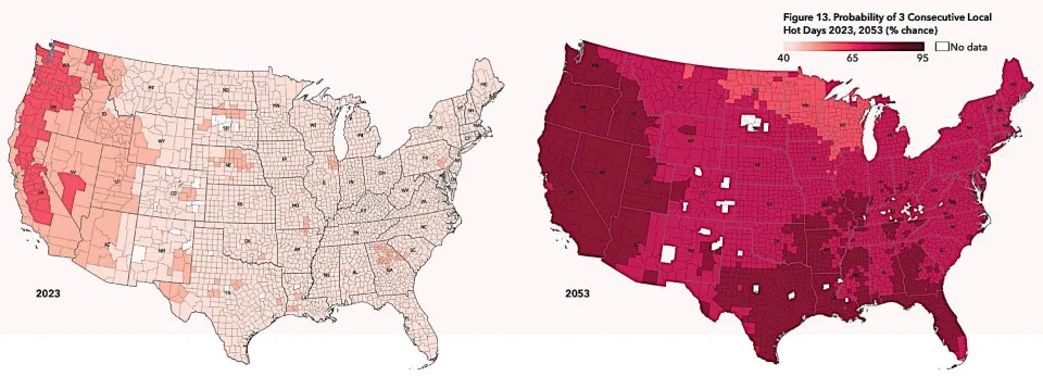
The county-by-county probability of a heat wave — three consecutive days above the 98th percentile for the local area — in 2023 (left) and 2053 (right).First Street Foundation
The projections in this report are conservative, since it assumed a future scenario where humans drastically cut the greenhouse-gas emissions that are driving climate change and increasing global temperatures.
If the world doesn’t cut emissions soon — particularly through a rapid transition away from fossil fuels to clean energy — the future of extreme heat could look even worse than the maps in this report.
“If anything, our undercuts or our underrepresentation of these heat impacts will be noticed in 30 years,” Eby said.
Even if humans stop emitting greenhouse gases tomorrow, some heating is locked in by the gases we’ve already added to the atmosphere. To protect life, infrastructure, and property, Eby said, individuals and companies and governments have to prepare for more extreme heat in the future.
“Our hope is that this data can inform everyone from the individual, to commercial users to state, local and federal governments, which are all users of our data,” he said.
Their data is publicly available on riskfactor.com, where you can check past data, as well as current and future risks for individual properties.
Why the Eastern Kentucky flood was no natural disaster. Let’s call it what it is
Charles Calhoun – August 16, 2022
It’s been two weeks since the historic and deadly flooding event in central Appalachia left 39 people dead and countless homes, businesses and lives destroyed. Naturally, narratives around this disaster have run amuck with some going so far as to name the very people dealing with it as the harbingers of their own destruction. And while this contributor will address that narrative below, there is another narrative that needs clarifying: The flood of July 28, 2022 was not a natural disaster.To imply this flood, along with so many other weather-borne catastrophes plaguing our world, is a natural disaster is to say three things: We don’t know why it happened, we don’t know how it happened and we don’t know how to prevent the next one. But we do know the answers to these questions. We’ve known them for some time. A combination of unfettered capitalism, environmental degradation through extraction economies and government indifference or plain inaction have borne a land in these hills ripe for weather related disasters and left behind communities with little to no defenses against them.
This disaster was man made. Strip mining and mountaintop removal reengineered the land and left communities and towns towards the valley floor exposed to record levels of storm runoff. Then the coal companies left and government officials let them offload their bonds tied to abandoned strip mining operations and their promise to clean up their mess. Logging companies also helped, clear cutting hillsides of trees capable of absorbing large amounts of moisture and holding the ground in place and leaving behind fields of kudzu, an invasive plant ill-suited for the job of mountain integrity. Throw in increased greenhouse gas emissions from the global industrialization of the 20th century and you have all the ingredients needed for continued and more frequent catastrophes.
This disaster is not the fault of those experiencing it. I consider myself an acquaintance of liberals and progressives and strive to abide no hate in the communities I live and work in. But to see folks of the same bent implying the assumed votes of the affected region in 2016 and 2020 and earlier are the reason why this man-made disaster has left them devastated is childish, infuriating and embarrassing.
To these same critical thinkers, I would ask: Will you say the same when the next disaster affects your democratic bulwark (i.e. Chicago, LA, Austin)? Did we not decry Sodom and Gomorrah references from conservatives after Hurricane Katrina? This is dangerously dualistic, incredibly callous and easily exploitable. We can’t be voices addressing climate change and in the same breath fall prey to such unscientific claims.
The science is clear
Finally, the next disaster is coming. The science is clear on this. The warmer our world becomes due to greenhouse gas buildup and environmental degradation, the more moisture will be absorbed into storms and the more volatile they will be, bringing prolonged rains and stronger winds. But when our government let the capitalists destroy these lands for profit and then let them off the hook for repairing them before they left, all while refusing any considerable legislation on addressing climate change, they left these communities vulnerable.
Without serious investments into repairing the land, rebuilding and refortifying infrastructure and providing those affected with free sturdy homes to replace the ones they lost, these man-made disasters will compound one after the other and the most vulnerable amongst us will suffer the consequences.
Charles Calhoun is a member of the Appalachian diaspora living in Columbia, SC but working remotely for an NPO in SEKY. He was present on the day of the floods.
Ringing in your ears? About 750 million people have this perplexing condition, study says
Christine Fernando – August 15, 2022
Tinnitus, commonly described as a ringing in the ears, may affect about 750 million people around the world, according to new research based on about 50 years of data.
Researchers estimate about 14% of adults experience tinnitus, and 2% experience a severe form of it. The prevalence also appears to increase with age: Tinnitus is reported in 10% of adults ages 18 to 44, 14% of adults ages 45 to 64, and 24% of those 65 and older.
“This study suggests that the global burden of tinnitus is large, similar to migraine and pain, and the lack of effective treatment options justifies a major investment in research in this area,” researchers wrote.
What is tinnitus?
While tinnitus is commonly known as a ringing sound in the ears, it can take many other forms, including buzzing, hissing, whistling, swooshing and clicking noises, according to the American Tinnitus Association (ATA). In rare cases, it can sound like music.
The condition can either be temporary or chronic, the ATA said. It’s not a disease in itself but is a symptom of other underlying health conditions, according to the association.
What causes tinnitus?
In most cases, tinnitus is a reaction in the brain to damage in the ear or auditory system, according to the ATA. However, the association says, tinnitus can also be a symptom of roughly 200 health problems, including hearing loss, obstructions in the middle ear, and head and neck trauma.
Even something as simple as a piece of earwax blocking the ear canal can cause tinnitus, the NIDCD said. The condition may also be the first sign of hearing loss in older adults or can be a side effect of more than 200 different medications.
Still, some people can develop tinnitus for no obvious reason, the institute said.
“Scientists still haven’t agreed upon what happens in the brain to create the illusion of sound when there is none,” the institute said.
Tinnitus usually isn’t a sign of a serious health problem, according to the NIDCD. But if it’s loud and persistent, it can cause memory and concentration problems, fatigue, anxiety and depression.
“For some, tinnitus can be a source of real mental and emotional anguish,” the institute said.
The ATA also said chronic tinnitus can be a debilitating condition that can interfere with a person’s ability to work and socialize.
Who is most at risk?
People at higher risk for tinnitus include older people, active military personnel or veterans, people who work in loud environments, and musicians, according to the ATA.
Military personnel can develop tinnitus when exposed to bomb blasts, and tinnitus is among the most common service-related disabilities for veterans returning from Iraq and Afghanistan, according to the NIDCD.
Is there a cure for tinnitus?
There is “no scientifically validated cure” for most forms of tinnitus, the ATA said. But treatment options can reduce the effects and help people live more comfortably.
The NIDCD recommends going to a primary care doctor to check if anything like ear wax is blocking the ear canal.
If a primary care doctor cannot find the condition that may be causing tinnitus, the physician may refer a patient to a otolaryngologist who specializes in the ear, nose and throat.
Treatments that may help tinnitus include hearing aids, counseling and wearable sound generators, the NIDCD said. Limiting exposure to loud noise also can help prevent tinnitus from worsening.
More river water tapped to meet Tampa Bay’s future thirst
C.T. Bowen, Tampa Bay Times – August15, 2022
CLEARWATER — New tap water for the Tampa Bay region will come from an old source.
On Monday, the board of Tampa Bay Water — the region’s wholesale water supplier — voted unanimously to expand an existing plant in Hillsborough County to treat more water drawn from the Hillsborough and Alafia rivers and the Tampa Bypass Canal.
The vote was the culmination of a nearly four year-long study on how to meet future water demands for residents and businesses in Hillsborough, Pinellas and Pasco counties and the cities of Tampa, St. Petersburg and New Port Richey.
The expanded plant has a projected construction cost of $90.7 million and will increase the water supply as much as 12 million gallons each day. So-called surface water treatment accounted for 43% of the 189 million gallons of water the utility delivered daily during July.
The board picked the expanded plant over more costly alternatives. Building a new surface water treatment facility near the C.W. “Bill” Young Regional Reservoir in eastern Hillsborough carried a price tag of $145.6 million and expanding the desalination plant in Apollo Beach had a projected expense of $310 million.
The expanded surface water plant, west of North Falkenburg Road, is expected to be completed by the end of 2028.
Pinellas County Commissioner Dave Eggers noted the expansion helps Tampa Bay Water move “a little bit, not much, but a little bit” away from its reliance on groundwater.
“I think it’s healthy,” Eggers said.
Tampa Bay Water is required to update its master water plan every five years and it already is beginning the revision to provide new water sources for 2033 and beyond. Both the expanded desalination plant and a new surface water treatment facility will be considered again as part of the update, said Maribel Medina, the utility’s senior engineering manager.
Hillsborough County Commissioner Harry Cohen said the utility needed to diversify its portfolio of future water sources since expanding an existing treatment plant meant Tampa Bay Water was “doubling down on one.”
“I think that as we do that (updating the future plan) we’ve got to go a little outside the box and start being a little more bold,” Cohen said. “If we’re going to be conservative in our approach this time around, which I think we are, I think we really need to look at new technology, and new sources in the next round.”
The U.S. could see a new ‘extreme heat belt’ by 2053
Denise Chow and Nigel Chiwaya– August 14, 2022
An “extreme heat belt” reaching as far north as Chicago is taking shape, a corridor that cuts through the middle of the country and would affect more than 107 million people over the next 30 years, according to new data on the country’s heat risks.
The report, released Monday by the nonprofit research group First Street Foundation, found that within a column of America’s heartland stretching from Texas and Louisiana north to the Great Lakes, residents could experience heat index temperatures above 125 degrees Fahrenheit by 2053 — conditions that are more commonly found in California’s Death Valley or in parts of the Middle East.
The projections are part of First Street Foundation’s new, peer-reviewedextreme heat model, which shows that most of the country will have upticks in the number of days with heat index temperatures above 100 degrees over the next 30 years as a result of climate change.
The heat index represents what a temperature feels like to the human body when humidity and air temperature are combined. It is commonly referred to as the “feels like” temperature.
“Everybody is affected by increasing heat, whether it be absolute increases in dangerous days or it’s just a local hot day,” said First Street Foundation’s chief research officer, Jeremy Porter, a professor and the director of quantitative methods in social sciences at the City University of New York.
It has already been a sweltering summer for much of the U.S. and Europe. The National Oceanographic and Atmospheric Administration’s latest monthly climate report, published Aug. 8, found that last month was the country’s third-hottest July since record-keeping began nearly 130 years ago.
As humans continue to pump heat-trapping greenhouse gases into the atmosphere, temperatures around the world are rising, which increases both the frequency of extreme heat events and their severity.
Researchers at First Street used their model to create an online tool called Risk Factor to give people hyperlocal snapshots of how their property is affected by extreme temperatures and what could change over the next three decades. The organization previously created similar resources to evaluate specific addresses’ risks from wildfires and flooding.
The new model uses high-resolution measurements of land surface temperatures and incorporates the effects of canopy cover, proximity to water and other factors that determine local temperature variability. Future heat risk is then calculated using different forecast scenarios for greenhouse gas emissions in the decades to come.
The researchers looked at the seven hottest days expected for any property this year and calculated what the equivalent could be in 30 years. Across the country, they found that, on average, a community’s seven hottest days are projected to become the location’s 18 hottest days by 2053.
The most pronounced shift was found in Miami-Dade County, Porter said, where the area’s seven hottest days, with heat index temperatures at 103 degrees, are projected to increase to 34 days at that temperature in 30 years.
But in addition to widespread increases in heat exposure, First Street’s model also identified what Porter and his colleagues call an “extreme heat belt” that covers about one-quarter of the country’s land area.
About 8.1 million U.S. residents in 50 counties are at risk of experiencing heat index temperatures over 125 degrees. But by 2053, the projection expands to more than 1,000 counties across an area that is home to more than 107 million people, according to First Street’s model.
The zone’s geographic boundaries and its sheer size were surprising, Porter said.
“How far north it stretched — I think a lot of people just hearing southern Wisconsin, Chicago and those areas being part of the extreme heat belt is surprising,” he added.
The agricultural impact of such a wide-ranging heat belt in the country’s heartland is particularly worrisome, said Noboru Nakamura, a professor of geophysical sciences at the University of Chicago, who was not involved with First Street’s research.
“If there are hot spots and dry spells in these places, farmers will have to shift their priorities and what types of crops they’ll plant, and that will all have a lot of long-term consequences,” Nakamura said.
There are also enormous public health and safety concerns with heat exposure, he added. Across the country, heat causes more deaths every year than any other weather event, according to the National Weather Service.
Sharp increases in extreme heat are likely to affect people’s lives and livelihoods in certain places, Nakamura said, and they could even play a factor in where people choose to call home.
“If a certain fraction of days per year are over 100 degrees, then unless you have the resources and infrastructure to stay cool, then it makes certain places very difficult to survive,” Nakamura said. “I can certainly envision that would shake up peoples’ decisions about where to live.”
Deadline looms for drought-stricken states to cut water use
Sam Metz and Felicia Fonseca – August 14, 2022
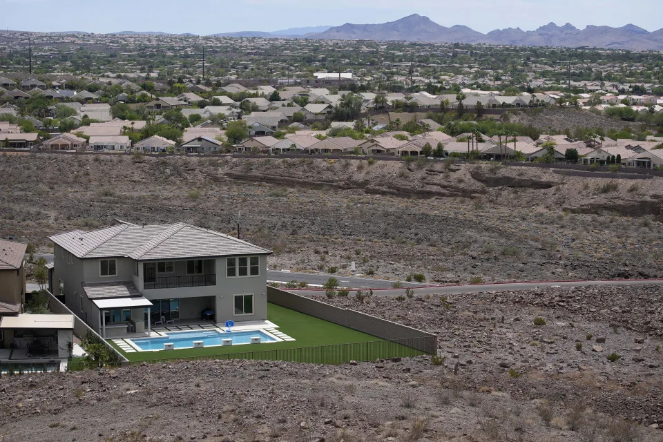
Visitors view the dramatic bend in the Colorado River at the popular Horseshoe Bend in Glen Canyon National Recreation Area, in Page, Ariz., on Sept. 9, 2011. Some 40 million people in Arizona, California, Colorado, Nevada, New Mexico, Utah and Wyoming draw from the Colorado River and its tributaries. The U.S. Bureau of Reclamation is expected to publish hydrology projections on Tuesday, Aug. 16, 2022, that will trigger agreed-upon cuts to states that rely on the river. (AP Photo/Ross D. Franklin, File) ASSOCIATED PRESSFarmer John Hawk looks over his land as his seed onion fields are watered in Holtville, Calif., Sept. 3, 2002. For the seven states that rely on the Colorado River that carries snowmelt from the Rocky Mountains to the Gulf of California, that means a future with increasingly less water for farms and cities although climate scientists say it’s hard to predict how much less. The U.S. Bureau of Reclamation is expected to publish hydrology projections on Tuesday, Aug. 16, 2022, that will trigger agreed-upon cuts to states that rely on the river. (AP Photo/Reed Saxon, File) ASSOCIATED PRESSA boat cruises along Lake Powell near Page, Ariz., on July 31, 2021. Seven states in the U.S. West are facing a deadline from the federal government to come up with a plan to use substantially less Colorado River water in 2023. The U.S. Bureau of Reclamation is expected to publish hydrology projections on Tuesday, Aug. 16, 2022, that will trigger agreed-upon cuts to states that rely on the river. Prolonged drought, climate change and overuse are jeopardizing the water supply that more than 40 million people rely on. (AP Photo/Rick Bowmer, File) ASSOCIATED PRESSA home with a swimming pool abuts the desert on the edge of the Las Vegas valley, Wednesday, July 20, 2022, in Henderson, Nev. The U.S. Bureau of Reclamation is expected to publish hydrology projections on Tuesday, Aug. 16, 2022, that will trigger agreed-upon cuts to states that rely on the river. (AP Photo/John Locher, File) ASSOCIATED PRESSA formerly sunken boat sits upright into the air with its stern stuck in the mud along the shoreline of Lake Mead at the Lake Mead National Recreation Area, Friday, June 10, 2022, near Boulder City, Nev. Lake Mead water has dropped to levels it hasn’t been since the lake initially filled over 80 years earlier. Prolonged drought, climate change and overuse are jeopardizing the water supply that more than 40 million people rely on. States are acknowledging that painful cuts are needed, but also stubbornly clinging to the water they were allocated a century ago. (AP Photo/John Locher, File) ASSOCIATED PRESSThe Colorado River flows at Horseshoe Bend in the Glen Canyon National Recreation Area, Wednesday, June 8, 2022, in Page, Ariz. Seven states in the U.S. West are facing a deadline from the federal government to come up with a plan to use substantially less Colorado River water in 2023. The U.S. Bureau of Reclamation is expected to publish hydrology projections on Tuesday, Aug. 16, 2022, that will trigger agreed-upon cuts to states that rely on the river. (AP Photo/Brittany Peterson, File) ASSOCIATED PRESSAn aerial view of Lake Powell on the Colorado River along the Arizona-Utah border on Sept. 11, 2019. The U.S. Bureau of Reclamation is expected to publish hydrology projections on Tuesday, Aug. 16, 2022, that will trigger agreed-upon cuts to states that rely on the river. (AP Photo/John Antczak, FIle ) ASSOCIATED PRESS
SALT LAKE CITY (AP) — Banks along parts of the Colorado River where water once streamed are now just caked mud and rock as climate change makes the Western U.S. hotter and drier.
More than two decades of drought have done little to deter the region from diverting more water than flows through it, depleting key reservoirs to levels that now jeopardize water delivery and hydropower production.
Cities and farms in seven U.S. states are bracing for cuts this week as officials stare down a deadline to propose unprecedented reductions to their use of the water, setting up what’s expected to be the most consequential week for Colorado River policy in years.
The U.S. Bureau of Reclamation in June told the states — Arizona, California, Colorado, Nevada, New Mexico, Utah and Wyoming — to figure out how to use at least 15% less water next year, or have restrictions imposed on them. On top of that, the bureau is expected to publish hydrology projections that will trigger additional cuts already agreed to.
“The challenges we are seeing today are unlike anything we have seen in our history,” Camille Touton, the bureau’s commissioner, said in a U.S. Senate hearing that month.
Tensions over the extent of the cuts and how to spread them equitably have flared, with states pointing fingers and stubbornly clinging to their water rights despite the looming crisis.
“It’s not fun sitting around a table figuring out who is going to sacrifice and how much,” said Bill Hasencamp, the Colorado River resources manager at Metropolitan Water District, which provides water to most of Southern California.
Representatives from the seven states convened in Denver last week for eleventh-hour negotiations behind closed doors. Officials party to discussions said the most likely targets for cuts are farmers in Arizona and California. Agricultural districts in those states are asking to be paid generously to shoulder that burden.
But the tentative agreements fall short of what the Bureau of Reclamation has demanded and state officials say they hope for more time to negotiate details.
The Colorado River cascades down from the Rocky Mountains into the arid deserts of the Southwest. It’s the primary water supply for 40 million people. About 70% of its water goes toward irrigation, sustaining a $15 billion-a-year agricultural industry that supplies 90% of the United States’ winter vegetables.
The river is divided among Mexico and the seven U.S. states under a series of agreements that date back a century, to a time when more water flowed through the river. But climate change has transformed the river’s hydrology, providing less snowmelt and causing hotter temperatures and more evaporation. As it’s yielded less water, the states have agreed to cuts tied to the levels of reservoirs that store river water.
Last year, federal officials for the first time declared a water shortage, triggering cuts to Nevada, Arizona and Mexico’s share of the river to help prevent the two largest reservoirs — Lake Powell and Lake Mead — from dropping low enough to threaten hydropower production and stop water from flowing through their dams.
The proposals for supplemental cuts due this week have inflamed disagreement between upper basin states — Colorado, New Mexico, Utah and Wyoming — and lower basin states — Arizona, California and Nevada — over how to spread the pain. The lower basin states use most of the water and have thus far shouldered most of the cuts. The upper basin states have historically not used their full allocations but want to maintain their water rights to plan for population growth.
Gene Shawcroft, the chairman of Utah’s Colorado River Authority, believes the lower basin states should take most of the cuts because they use most of the water and their full allocations.
He said it was his job to protect Utah’s allocation for growth projected for decades ahead: “The direction we’ve been given as water purveyors is to make sure we have water for the future.”
In a letter last month, representatives from the upper basin states proposed a five-point conservation plan that they said would save water but argued most of the cuts needed to come from the lower basin. The plan didn’t commit to any numbers.
“The focus is getting the tools in place and working with water users to get as much as we can rather than projecting a water number,” Chuck Cullom, the executive director of the Upper Colorado River Commission, told The Associated Press.
That position, however, is unsatisfactory to many in lower basin states already facing cuts.
“It’s going to come to a head particularly if the upper basin states continue their negotiating position, saying, ‘We’re not making any cuts,’” said Bruce Babbitt, who served as Interior secretary from 2003-2011.
Lower basin states have yet to go public with plans to contribute, but officials said last week that they had a tentative proposal to reduce consumption that fell slightly short of the federal government’s request to cut 2 to 4 million acre-feet.
An acre-foot of water is enough to serve 2-3 households annually.
Hasencamp, the Metropolitan Water District’s Colorado River resource manager, said all the districts in the state that draw from the river had agreed to contribute water or money to the plan, pending approval by their respective boards. Water districts, in particular the Imperial Irrigation District, have been adamant that any voluntary cut does not curtail their high priority water rights.
Southern California cities likely will be putting up money that could fund fallowing farmland in places like Imperial County and water managers are considering leaving water they’ve stored in Lake Mead as part of their contribution.
Arizona will likely be hit hard with reductions. The state has in the past few years shouldered much of the cuts and with its growing population and robust agricultural industry, has less wiggle room than its neighbors to take on more, said Arizona Department of Water Resources Director Tom Buschatzke. Some tribes in Arizona have also contributed to propping up Lake Mead in the past, and could play an outsized role in any new proposal.
Irrigators around Yuma, Arizona, have proposed taking 925,000 acre-feet less of Colorado River water in 2023 and leaving it in Lake Mead if they’re paid $1.4 billion, or $1,500 per acre-foot. The cost is far above the going rate, but irrigators defended their proposal as fair considering the cost to grow crops and get them to market.
Wade Noble, the coordinator for a coalition that represents Yuma water rights holders, said it was the only proposal put forth publicly that includes actual cuts, rather than theoretical cuts to what users are allocated on paper.
Some of the compensation-for-conservation funds could come from a $4 billion drought earmark in the Inflation Reduction Act under consideration in Washington, U.S. Sen. Kyrsten Sinema of Arizona told the AP.
Sinema acknowledged paying farmers to conserve wasn’t a long-term solution: “In the short-term, however, in order to meet our day-to-day needs and year-to-year needs, ensuring that we’re creating financial incentives for non-use will help us get through,” she said.
Babbitt, too, said money in the legislation will not “miraculously solve the problem” and prices for water must be reasonable to avoid gouging because most water users will take a hit.
“There’s no way that these cuts can all be paid for at a premium price for years and years,” he said.
Fonseca reported from Flagstaff, Arizona. Associated Press reporter Kathleen Ronayne contributed from Sacramento, California.
Saudi firm has pumped Arizona groundwater for years without paying. Time to pony up
Bruce Babbitt and Robert Lane – August 11, 2022
The Butler Valley is an empty stretch of desert west of Phoenix, worthy of note for two reasons.
It holds more than 6 million acre-feet of groundwater, strategically located near the Central Arizona Project canal.
And more than 99% of Butler Valley is owned by the state of Arizona in trust for the support of public schools.
In 1982 as the Central Arizona Project canal neared completion, Wes Steiner, the renowned director of the Department of Water Resources, proposed that the state set aside Butler Valley as a groundwater reserve for future use in connection with the CAP.
Acting on his advice, we worked with the federal Bureau of Land Management to transfer the Valley into state ownership to be managed by the State Land Department.
How much water has Fodomonte pumped?
In June, The Arizona Republic uncovered the story of how the State Land Department had recently handed over thousands of acres to a Saudi corporation called Fondomonte, giving it permission to pump unlimited amounts of groundwater to grow alfalfa hay for export to Saudi Arabia.
This tale of official misfeasance began in 2015 when the State Land Department began leasing land to Fondomonte at an annual rental of just $25 per acre.
However, the 2015 lease in addition allowed Fondomonte to pump unlimited amounts of groundwater at no cost whatever.
How much is Fondomonte pumping? The company refuses to disclose how much water it uses each year, and the State Land Department has never bothered to demand reports. That Fondomonte is growing alfalfa year round on approximately 3,500 acres can be verified from aerial photos.
And according to U.S. Geological Survey studies, alfalfa in Butler Valley requires 6.4 acre-feet of water per acre. That means the company has likely been pumping 22,400 acre-feet of water each year for the last 7 years.
Void its lease, charge for past rent
How much should the state be charging for this water? The Arizona Constitution, Article 10, Section 4, requires that land leases and “products of land” … “shall be appraised at their true value.”
The appropriate method for determining true value is hiding in plain sight. The Central Arizona Project sells water to customers throughout Maricopa County for $242 per acre foot delivered through the project canal that passes just south of Butler Valley.
Add these figures, and Fondomonte should have been paying $5.42 million per year for each of the last seven years.
What should be done to clean up this scandal? First, Gov. Doug Ducey should instruct the State Land Department to void the lease and restore Butler Valley to its intended use as a groundwater reserve for the future.
Second, Gov. Ducey should instruct the attorney general to collect past due rentals of about $38 million to be held in trust for the benefit of Arizona school children.
Bruce Babbitt served as governor of Arizona from 1978 to 1987. Robert Lane served as State Land commissioner from 1982 to 1987.
Record Death Valley flooding ‘a once-in-1,000-year event’
Gabrielle Canon – August 10, 2022
Recent severe rains in Death Valley that flushed debris across roadways, damaged infrastructure and carried away cars are being described by meteorologists and park officials as a once-in 1,000-year event.
The arid valley was pelted with roughly an inch and a half of rain on Friday, near the park’s rainfall record for a single day.
The storm poured an amount of water equal to roughly 75% of the average annual total in just three hours, according to experts at Nasa’s Earth observatory. Hundreds visiting and working in Death Valley national park were marooned and all roads continue to be impassable, according to park officials.
The waters have receded, leaving behind thick layers of mud and gravel, but those who were stranded were able to exit the park earlier this week, aided by park service personnel.
But events like this one, once thought to be exceedingly rare, are on the rise. Scientists are finding that weather extremes, fueled by the climate crisis, are becoming more likely in the American west, which continues to be mired in drought. Periods of dryness are expected to be broken with strong, destructive storms as the world continues to warm.
No injuries have been reported but aerial searches are being conducted by the California highway patrol and naval aircraft, the National Park Service said in a statement, to confirm that vehicles are not still stranded in remote areas of the park.
In a statement, the park superintendent, Mike Reynolds, said it would “take time to rebuild” and noted that officials were still working to assess destruction from the storm across the roughly 3.4m acres and more than 1,000 miles of roads in the park.
While the storm did not break Death Valley’s all-time record for daily rainfall, it did break records for this time of year, as August generally produces just a tenth of an inch of rain.
Nasa satellites were able to capture the storm’s effects, showing a belt of blue across the typically brown terrain.
“This week’s 1,000-year flood is another example of this extreme environment,” Reynolds said. “With climate change models predicting more frequent and more intense storms, this is a place where you can see climate change in action.”