‘They screwed up our lake’: tar sands pipeline is sucking water from Minnesota watersheds

‘They screwed up our lake’: tar sands pipeline is sucking water from Minnesota watersheds

Low water levels mean rice harvesters can’t paddle their canoes to their traditional harvesting areas.
Photograph: Kerem Yucel/AFP/Getty Images


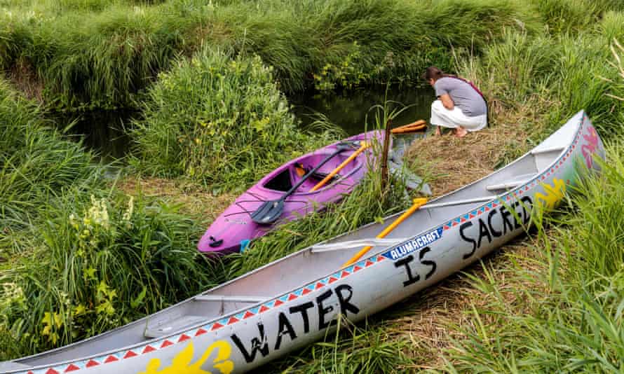
Along the eastern boundary of the White Earth Indian Reservation in north-western Minnesota, Indigenous Anishinaabe wild rice harvesters Jerry and Jim Libby set down a row of wooden pallets into the mud just beyond the dock of Upper Wild Rice Lake. It was a clear day, and tight, lush clumps of green rice heads were visible across the lake’s horizon.

In a typical year, the entrance to this – one of a long necklace of wild rice lakes in northern Minnesota to which the region’s Indigenous people flock every year in the late summer – would be covered in at least two feet of water. But now it is composed of suspended sediment as solid as chocolate pudding, through which the Libbys need to create a makeshift ramp simply to carry their canoe out to the waterline.

Minnesota is weathering an historic drought, but there is another problem beyond the weather: Enbridge’s Line 3 tar sands pipeline has taken a substantial toll on watersheds in the region, including through a permit to pump five billion gallons of water for construction. In the case of Upper Wild Rice Lake, a road construction contractor named Knife River Construction stuck a pump directly in the lake this past June, sucking out an unknown quantity of water, which locals suspect was related to the use of heavy trucks for the pipeline.

“As far as I’m concerned, Enbridge screwed up our lake, and they’re taking money directly away from our families,” Jerry Libby says. “It makes us feel anguished – this is our staple food, you know.”

The Indigenous-led struggle against Line 3, which seeks to move 930,000 barrels of tar sands bitumen daily from Alberta to a shipping and refinery hub in Superior, Wisconsin, has been the biggest environmental and Indigenous land protection campaign in the US this summer. More than 900 people have been arrested opposing the pipeline, including nearly 70 who were kettled in late August during protests outside Minnesota governor Tim Walz’s residence in Minneapolis.

Branded as a “replacement” project, the new pipeline would double the old Line 3’s capacity to carry tar sands bitumen. Enbridge, a Canada-based energy company, has announced it will begin sending oil through the pipeline next month.

The processing and combustion of bitumen for the pipeline would release greenhouse gases equivalent to 50 coal plants, according to analysis by the nonprofit Oil Change International, thereby significantly contributing to the global climate crisis. But one of the pipeline’s most immediate impacts is on wild rice harvesters such as the Libbys, for whom the annual harvesting season began in late August and runs through much of September.

Wild rice – known to many Anishinaabe people as “manoomin,” or “the food that grows on water” – is a dense, nutritional grain that grows naturally in the abundant lakes and rivers in Minnesota, Wisconsin and parts of Canada. Thousands of Anishinaabe people continue to harvest it with the same traditional methods used for generations, by propelling a canoe or small boat through the rice beds with a long pole.

Indigenous people of the region believe they have a sacred covenant to protect manoomin and numerous other nonhuman beings, without which they would cease to exist as distinct peoples, notes longtime Anishinaabe rice harvester Bob Shimek. “During any kind of ceremony we do here, wild rice is involved,” Shimek says. “It’s kind of like the Anishinaabe soul food.”

Line 3 runs across more than 200 bodies of water, including the headwaters of the Mississippi River and some of the region’s most important wild rice waters, streams, rivers, lakes and aquifers. The state Department of Natural Resources permitted Enbridge to draw nearly five billion gallons from these water bodies absent public notice or consultation with the White Earth Indian Reservation.

Christy Dolph, a University of Minnesota research scientist focused on the state’s water resources, notes that the pipeline’s impacts on water and the species that depend on it are numerous. In the course of excavating trenches to lay pipe, Enbridge pumps out any groundwater that still seeps into the trench, inevitably leading water to evaporate.

“These activities have a major impact, especially because these wetlands are already under severe stress from the drought,” she says.

Opponents also fear leaks and spills from the tar sands pipeline, particularly since the thick substance is nearly impossible to clean up.

As with other wetland plant species, wild rice is highly sensitive to fluctuations in water levels, which damage its ability both to grow and reseed. For rice harvesters, low water levels mean they are unable to paddle their canoes out to their usual rice grounds, depriving them of a major source of physical and spiritual sustenance, as well as a significant source of income.

During a typical year, the Libby brothers say, they make up to $9,000 from rice harvesting, which they use for basic necessities like home repairs, school supplies for their grandchildren and vehicle maintenance. But since this year’s harvesting season began in late August, many harvesters have had to resort to unorthodox methods such as trekking through the muddy, dried-out lakes in snow shoes with burlap sacks slung around their shoulders, a technique that yields one-third to one-fourth the amount they could harvest with canoes.

Enbridge disputes the notion that they bear any responsibility for the dry conditions in rice beds near the pipeline route or that the pipeline has a detrimental impact on watersheds. “Line 3’s permit conditions protect the environment during construction, and specifically wild rice,” Enbridge spokersperson Juli Kelner wrote via email. “Enbridge pipelines have coexisted with Minnesota’s most sacred and productive wild rice stands for seven decades.”

In response to a request for comment, a Department of Natural Resources spokesperson wrote that “Minnesota DNR has worked consistently to minimize the impacts of the Line 3 replacement project on wild rice and other Minnesota resources. These efforts date back to our original comments to the Minnesota Public Utilities Commission (PUC) regarding project routing, where we strongly advocated for route alternatives that would minimize crossings in or near wild rice waters.”

The effects of Line 3 construction on wild rice are at the center of a first of its kind lawsuit brought by the White Earth Band of Ojibwe in which wild rice is itself the plaintiff. Under a series of treaties that Chippewa Anishinaabe people signed with the US government during the mid-19th century, the lawsuit asserts, wild rice “possesses inherent rights to exist, flourish, regenerate, and evolve, as well as inherent rights to restoration, recovery, and preservation.” The suit seeks an injunction against the Department of Natural Resources to void Enbridge’s water permit, though the case may not be decided until after construction is completed.

Beyond the direct effects of the Line 3 pipeline, wild rice faces numerous other threats – including from the climate crisis. According to a 2018 report by the Great Lakes Indian Fish and Wildlife Commission (GLIFWC), an intertribal agency that seeks to protect Anishinaabe treaty rights, climate change will wreak devastation on virtually all the plant and animal species on which they rely. Wild rice is the most endangered of these species because of its sensitivity to flooding, drought, and disease outbreaks, the report says.

Stopping Line 3 is imperative to fighting the climate crisis, opponents note, because tar sands are one of the most intensive fossil fuels in terms of carbon dioxide emissions and because the construction of new fossil fuel infrastructure locks in emissions for decades to come. For the past several months, activists have called on the Biden administration to stop the pipeline by directing the Army Corps of Engineers to revoke the permit it granted the project under the Trump administration.

According to Anishinaabe wild rice harvester Angel Stevens, a member of the anti-pipeline Manoomin Camp, the struggle against Line 3 is still going strong despite the project’s imminent completion. “We’re continuing to do everything we can to stop this pipeline,” she says.

Guess what the three Democrats blocking lower medication prices have in common?

Guess what the three Democrats blocking lower medication prices have in common?

Photograph: Daniel Knighton/Getty Images


The three conservative Democratic lawmakers threatening to kill their party’s drug pricing legislation have raked in roughly $1.6m of campaign cash from donors in the pharmaceutical and health products industries. One of the lawmakers is the House’s single largest recipient of pharmaceutical industry campaign cash this election cycle, and another lawmaker’s immediate past chief of staff is now lobbying for drugmakers.

The threat from Democratic representatives Kurt Schrader (Oregon), Scott Peters (California) and Kathleen Rice (New York) comes just as the pharmaceutical industry’s top lobbying group announced a seven-figure ad campaign to vilify the Democratic legislation, which aims to lower the cost of medicines for Americans now facing the world’s highest prescription drug prices.

Schrader and Peters are among the two biggest recent Democratic recipients of pharmaceutical industry donations

At issue is House Democrats’ initiative to let Medicare use its bulk purchasing power to negotiate lower prescription drug prices. That power – which is used by other industrialized countries to protect their citizens from exorbitant prices – has been promised by Democrats for years, and party leaders have been planning to include it as part of their sprawling $3.5tn infrastructure reconciliation effort.

On Wednesday, Schrader, Peters and Rice helped vote the measure down in the powerful energy and commerce committee, blocking the legislation before it could come to the House floor for a vote. Even if the bill were to ultimately make it to the floor through another committee – which remains a possibility – Democrats have only a four-seat majority that allows them to pass legislation, so they can’t afford to lose any more votes.

“I understand that the pharmaceutical industry owns the Republican party and that no Republican voted for this bill, but there is no excuse for every Democrat not supporting it,” said the Vermont Senator Bernie Sanders after the vote.

The trio of Big Pharma Democrats are jeopardizing a plan based on HR 3, the Elijah E Cummings Lower Drug Costs Now Act. The Congressional Budget Office has said the drug pricing legislation, named for the late Representative Elijah Cummings of Maryland, would save the government $456bn and “reduce prices by 57% to 75%, relative to current prices” for various medicines.

The measure would direct federal health regulators to negotiate prices of 25 high-priced drugs in the first year of implementation and 50 drugs in subsequent years, and the new negotiated prices would be available to both Medicare and private insurers.

Polls show that the idea of allowing Medicare to negotiate drug prices is wildly popular – to the point where swing-state Republicans and swing-district Democrats, and even former President Donald Trump, have expressed support for it.

Schrader and Peters are among the two biggest recent Democratic recipients of pharmaceutical industry donations, according to OpenSecrets. The pharmaceutical and health products industries are collectively the second biggest donor to both lawmakers over the course of their careers, giving them almost $1.5m in total. Peters is the House’s top recipient of pharmaceutical industry donations in the 2022 election cycle.

Related: Big Pharma doesn’t want us to expand Medicare. We have to fight them | Bernie Sanders

Peters and his family were worth an estimated $60m in 2018, making him one of the wealthiest lawmakers in Congress, according to OpenSecrets. His wife is the president and CEO of Cameron Holdings, an investment firm whose portfolio company provides manufacturing and packaging for pharmaceutical companies.

Schrader’s net worth, meanwhile, was pegged at nearly $8m. The Oregonian reported in 2008 that he received “a quite large inheritance” from his grandfather, who was “vice president and director of biochemical research and development at Pfizer” – the drugmaker whose political action committee is now Schrader’s third largest career donor.

The congressmen on Tuesday offered their own drug pricing proposal, which would allow Medicare to negotiate prices only under limited conditions, such as when a company no longer has exclusive marketing rights on an older drug but there are no competitors. That proposal was also backed by the Democratic representative Stephanie Murphy (Florida), the co-chair of the conservative Blue Dog Coalition, who is the House’s fifth largest recipient of donations from the pharmaceutical and health products industries.

Earlier this year, Peters’ campaign saw a surge in donations from pharmaceutical company executives after he organized a letter with nine other Democratic lawmakers informing the House speaker, Nancy Pelosi, that they opposed HR 3. Schrader and Rice co-signed the letter.

It’s worth noting that Peters, Schrader and Rice all voted in favor of HR 3 in the previous Congress. Politico wrote in May that Peters “said he cast that vote knowing it had no chance of becoming law at the time. He said he supported it only to ‘start a conversation about lowering the cost of prescription drugs’.”

Rice, Schrader and Peters have seats on the House energy and commerce committee, which is writing the party’s prescription drug plan, and they used those positions to help block the measure there on Wednesday, preventing it from moving to the floor.

Last December, House Democrats’ steering committee voted to put Rice on the energy and commerce panel instead of the progressive New York representative Alexandria Ocasio-Cortez.

On Tuesday, Rice explained that she opposes the drug pricing measure because “I do not support advancing policies that are not fiscally responsible and jeopardize the bill’s final passage.”

Schrader’s longtime top aide, Paul Gage, left the congressman’s office earlier this year, according to Legistorm, and quickly started lobbying for Pharmaceutical Research and Manufacturers of America (PhRMA), the powerful Washington drug lobby.

Gage has been lobbying Congress on drug pricing issues and HR 3, according to ethics records. PhRMA raised more than $500m in 2019, and the organization is one of the top lobbying spenders in DC.

On Wednesday, PhRMA announced it is launching an ad campaign against House Democrats’ drug pricing efforts. “Politicians say they want to negotiate medicine prices in Medicare,” one ad warns. “But make no mistake: What politicians mean is they’ll decide which medicines you can and can’t get.”

The Blue Dog Coalition’s political action committee has been making monthly payments to a consulting firm led by the coalition’s former communications director, Kristen Hawn.

Hawn is also a partner at the bipartisan public affairs firm ROKK Solutions, which has worked for PhRMA.

  • David Sirota is a Guardian US columnist and an award-winning investigative journalist. He is an editor-at-large at Jacobin, and the founder of the Daily Poster. He served as Bernie Sanders’ presidential campaign speechwriter
  • Andrew Perez is a senior editor at the Daily Poster and a cofounder of the Democratic Policy Center
  • This article was originally published in the Daily Poster, a grassroots-funded investigative news outlet

Three Weeks After Hurricane Ida, Parts of Southeast Louisiana Are Still Dark

Three Weeks After Hurricane Ida, Parts of Southeast Louisiana Are Still Dark

Downed power lines in Luling, La. on Sept. 11, 2021. (Emily Kask/The New York Times)


NEW ORLEANS — For Tiffany Brown, the drive home from New Orleans begins as usual: She can see the lights on in the city’s central business district and people gathering in bars and restaurants. But as she drives west along Interstate 10, signs of Hurricane Ida’s destruction emerge. Trees with missing limbs fill the swamp on either side of the highway. With each passing mile, more blue tarps appear on rooftops and more electric poles lay fallen by the road, some snapped in half.

By the time Brown gets to her exit in Destrehan 30 minutes later, the lights illuminating the highway have disappeared, and another night of total darkness has fallen on her suburban subdivision.

For Brown, who works as an office manager at a pediatric clinic, life at work can feel nearly normal. But at home, with no electricity, it is anything but. “I keep hoping every day that I’m going to go home and it’ll be on,” she said. “But every day it’s not.”

Three weeks have passed since Hurricane Ida knocked down electric wires, poles and transmission towers serving more than 1 million people in southeast Louisiana. In New Orleans, power was almost entirely restored by Sept. 10, and businesses and schools have reopened. But outside the city, more than 100,000 customers were without lights through this past Monday. As of Friday evening, there were still about 38,000 customers without power, and many people remained displaced from damaged homes.

As intensifying storms driven by climate change reveal the weakness of electric grids across the United States, severe power outages are becoming an increasingly regular long-term aftershock.

“It so quickly pivots from the disaster itself — the hurricane, the wildfire, the floods,” said Julie McNamara, an energy analyst with the Union of Concerned Scientists. “So much of the consequences of these extreme weather events are because of those long-lasting power outages.”

For many, like Brown, getting the lights back on could still be more than a week away: Entergy, the state’s largest utility, estimates that power will be fully restored in the state by Sept. 29, a full month after Ida made landfall. Linemen are scattered across the coast replacing downed wires and poles, but in some areas hit by sustained winds as high as 150 mph, electrical systems will need to be completely rebuilt.

The challenges of weeks without power are wearing on residents. Kelly Walker, who lives in Luling, Louisiana, went almost three weeks with no electricity before the lights were finally restored Friday. Her mother’s small three-bedroom house became a crowded home base to eight people, with a generator tempering the sweltering heat at a cost of often $80 per day in gasoline. With no hot water to take a shower, the grocery stores still poorly stocked, her 14-year-old son’s school closed indefinitely, and little to do for entertainment, the family saw tensions run high.

“It seems in the big picture things are coming together,” said Walker. “But it feels like the outskirts, little towns and communities, are getting left behind.”

Everywhere from St. Charles Parish, where Walker lives, to Thibodaux more than 30 miles west, and 50 miles south to Grand Isle — an expanse that includes bedroom communities, fishing towns and small cities of oil and gas workers — power outages have led to a cascade of challenges.

Jobs, schools and daily routines remain on hold across the region. Workers on cherry pickers string new power lines along roads as drivers wait their turn at dead traffic lights. On some residential streets, power lines hang so low that cars just barely scrape under them.

The Terrebonne Parish school district, where just over a dozen of 34 schools had power as of Friday, has been closed for weeks. The district is “not even contemplating” reopening school buildings until they have electricity, said Philip Martin, the school superintendent. Schools farther north with power and less damage will temporarily house students from the southern reaches of the parish starting Sept. 27. But without the lights on, it has been challenging to even assess the wind damage to school buildings to determine how long that fix will be necessary.

Medical facilities are struggling, too. The urgent care clinic that Alicia Doucet manages in Cut Off, a small fishing town along the bayou southwest of New Orleans, reopened a week after the storm hit, when the staff finally secured a generator. But a week later, the gasoline costs to run it were adding up. Supplies including medications and crutches were slow to arrive as delivery trucks struggled to make it through the debris to reach the clinic.

“We’re just praying that each one that comes in, we’re able to treat,” Doucet said. The hospital will be shut down for months after losing its roof in the storm, according to Lafourche Parish President Archie Chaisson, forcing the clinic to send those in need of more acute care to the hospital in Thibodaux, an hour away.

The enduring blackout has stalled the rebuilding process in communities like Pointe-Aux-Chenes, a small community of homes, many raised on stilts, across the marsh from Doucet’s clinic that is home to the Pointe-au-Chien tribe.

“No water, no electricity, so you can’t do nothing,” Charles Verdin, the tribal chair, said. Most residents have yet to return to the community, where the intense winds rendered most homes uninhabitable.

And with every passing day, the already immense task of rebuilding becomes more daunting as rain falls through holes in rooftops and mold spreads.

Verdin said it was not until Sept. 13, more than two weeks after the storm, that he first saw workers make their way down the bayou to start repairing the power lines. He understands the obstacles they face: Piles of debris and downed wires make the already lengthy drive from the community to any population center far longer. Many downed poles were planted in soft, swampy soil, making them difficult to fix.

But he also believes that restoring power to his community was low on the list of priorities of the utility company.

“We don’t like it, but we’re used to it. They’ll take care of where the most population is,” said Verdin.

Entergy spokesperson Jerry Nappi confirmed that the company prioritizes getting the greatest number of customers’ power back the fastest, with lines that serve fewer people restored later.

The immense challenge of repairing more than 30,000 poles, 36,000 spans of wire and nearly 6,000 transformers brought down by the storm has left many wondering whether Entergy should have invested more in strengthening this infrastructure to be able to withstand the heavy winds that wallop the Gulf Coast with increasing regularity.

State regulators asked that question in 2019, when the Louisiana Public Utilities Commission opened an inquiry into grid reliability. But the proceeding remains open, and regulators have done little to compel Entergy to answer for outages, even as long-term blackouts become more frequent.

After Hurricane Laura tore through the southwest part of the state last August, causing more than 400,000 outages in Louisiana, it took more than a month for the utility to restore power to all customers, at an estimated cost of up to $1.4 billion. A month later, it took two weeks for Entergy to fully restore power after Hurricane Zeta knocked out power to nearly a half-million customers in the state.

For many, getting power back after Hurricane Ida is just the beginning.

Last weekend, Anthony Griffith and Brittany Dufrene surveyed their house in LaPlace after a demolition crew had gutted it, two weeks after Hurricane Ida brought a surge of floodwater from nearby Lake Pontchartrain into their subdivision.

Their plan “for now” is to rebuild, Dufrene said, and she expects that many of her neighbors will, too. But with storms hitting the area more often, the longer-term solution is less clear. “How many times can you do that?” she asked.

From down the driveway, a neighbor called out that he had gotten power. Griffith flicked a switch on the fuse box, and sure enough, for the first time in nearly two weeks, it turned on.

Maybe now they could stay at home, Griffith suggested, instead of bouncing between relatives’ houses over an hour apart.

Dufrene laughed, looking at the mattresses stacked in the garage and at the walls with the bottom few feet removed.

“Where are we going to stay?” Dufrene asked. “Where are we going to sleep?

Milley took action because gutless GOP wouldn’t stand up to mentally unbalanced Trump | Opinion

Milley took action because gutless GOP wouldn’t stand up to mentally unbalanced Trump | Opinion

What do you do when a president is crazy?

That’s essentially the question Gen. Mark Milley, chairman of the Joint Chiefs of Staff, faced in the twilight days of the Trump administration. His answer, as reported by Bob Woodward and Robert Costa in their forthcoming book, “Peril,” has some people up in arms.

It seems that Milley, according to published accounts from those who have read the book, became convinced his tantrum-throwing, spittle-spewing, reality-denying commander-in-chief was in a state of mental collapse and, as such, was an immediate threat to world peace. So the general went around him, twice reaching out via back channels to his Chinese counterpart, General Li Zuocheng.

The first call was last October. Milley had reportedly seen intelligence suggesting that China, rattled by U.S. military exercises in the South China Sea and by President Trump’s bellicose rhetoric, believed an American attack was imminent. He assured Zuocheng that this was not the case and went so far as to issue an extraordinary promise: “If we’re going to attack, I’m going to call you ahead of time.”

Milley’s second call is said to have come in the wake of the Jan. 6 insurrection at the Capitol. He reportedly felt it necessary to assure China the U.S. government was stable, appearances to the contrary notwithstanding. Milley also warned military officers against obeying any presidential orders to launch nuclear weapons unless he, Milley, was involved.

The propriety of Milley’s actions has come under heavy scrutiny. Trump-era National Security Adviser John Bolton defended him and vouched for his patriotism. Pentagon spokesman John Kirby said that reassuring a nervous adversary is “not only common, it’s expected.”

Florida Sen. Marco Rubio, on the other hand, expressed “grave concern” and demanded that President Biden fire Milley “immediately.” Nor was the condemnation limited to morally limber political actors. Former Army Lt. Col. Alexander Vindman, who famously testified against Trump in his first impeachment and paid for his temerity with his career, said Milley must resign, having “violated the sacrosanct principle of civilian control over the military,” which he saw as “an extremely dangerous precedent.”

But the Trump years set extremely dangerous precedents on a daily basis. It is at least conceivable that this one averted war. And none of this Sturm und Drang addresses what would seem to be the obvious issue. Namely, that the question of how to manage a mentally unbalanced president should never have devolved to Milley to begin with, should never have become his responsibility.

That it did speaks to the unadulterated cowardice of the political party that protected Trump, made excuses for him, lied for him, at every step of the way. As his precarious mental state became ever more obvious, the GOP’s pusillanimous refusal to do its patriotic duty became ever more glaring.

Impeach him? Invoke the 25th Amendment? Simply stand up on hind legs and object?

Nope, nope and nope. Instead, the Gutless Old Party behaved like Mikey’s brothers in the old Life cereal commercial: “I’m not gonna try it. You try it.”

Now we’re supposed to dump opprobrium upon a soldier who was required to answer a question that never should’ve come to his desk and never would’ve, had these people exhibited a molecule of courage? No. The most troubling thing here is not what Milley chose to do.

It’s that he had to make a choice at all.

Rising seas, sinking land: Life on this Hurricane Ida-battered Louisiana barrier island may never be the same

Rising seas, sinking land: Life on this Hurricane Ida-battered Louisiana barrier island may never be the same
A sand-filled tube known locally as "the burrito" has protected Grand Isle, Louisiana, from the worst of storm erosion, but Hurricane Ida blasted through portions of it, inundating sections of the island with sand and seawater.
A sand-filled tube known locally as “the burrito” has protected Grand Isle, Louisiana, from the worst of storm erosion, but Hurricane Ida blasted through portions of it, inundating sections of the island with sand and seawater.


GRAND ISLE, Louisiana — Jules Melancon steps over roofing shingles littering his yard, around a downed tree and ducks beneath a twisted aluminum beam of the shed in his backyard.

“I was lucky, I tell you,” the third-generation oyster farmer says. “My house came through OK.”

Looking around, Melancon points out the destruction caused to this tortilla-flat barrier island when Hurricane Ida roared ashore 10 days prior, ripping holes in the island’s defensive levees, pouring saltwater onto low-lying areas and inundating others with several feet of sand while ripping apart homes and businesses.

Virtually every building suffered some damage, and as many as 40% of the houses and summer homes known as “camps” were destroyed, according to authorities. The island was declared effectively uninhabitable, water service was severed, and power is not expected back until month’s end.

Climate Point: Subscribe to USA TODAY’s weekly newsletter on climate, energy and the environment

With insurance and FEMA assistance, Melancon, 63, is already making plans to repair his oyster-sorting shed, to clean his yard of debris, and to replace the lawnmower swamped by Hurricane Ida’s storm surge.

But while Melancon suffered relatively little damage this time, things could have been much worse, not just for him but for all of the approximately 1,500 people who call this island home, and for the tens of thousands more who vacation here each summer. Experts say Grand Isle is a harbinger for things to come: rising sea levels, stronger storms and more destruction for coastal areas.

Third-generation oyster farmer Jules Melancon stands in the garage area of his home on Grand Isle, Louisiana, following the passage of Hurricane Ida.


With sea levels rising an average of 3.6 millimeters annually due to climate change, Louisiana’s coast is simultaneously sinking, possibly in connection with the vast amounts of oil, natural gas and water that have been extracted over the past decades to fuel and power the United States.

That means places like Grand Isle, reached by a long causeway from mainland Louisiana, is demonstrating today what other coastal areas will see in the coming years.

And it raises questions about how long governments will try to protect property and how much tax money they’re willing to spend rebuild roads and power lines and homes before ceding it to the sea. In 2014, federal scientists said Grand Isle sank 1.3 inches in five years, one of the largest drops globally.

“The Louisiana coast is in general a canary in the coal mine,” said Samuel Bentley, a Louisiana State University expert on coastal erosion. “We are experiencing conditions now that other areas will face in the future. From the perspective of a homeowners or a city official, it doesn’t matter if it’s subsidence or sea level rise. It becomes a political decision at some point.”

The history of ‘hauntingly beautiful’ Grand Isle, Louisiana

Federal, state and local officials have long known the danger faced by Grand Isle, which under normal circumstances is a bucolic, sandy island with shave ice shops, fishing rodeos and beach bar after beach bar.

Last year, the New York Times declared the island one of its top places to visit for 2020, ranking it with Greenland, Tokyo and the British Virgin Islands. But the reporter also asked, “Does a place appear more hauntingly beautiful when you know it’s disappearing?”

First used by indigenous, nomadic natives, the Grand Isle and nearby Chenière Caminada and Leeville areas grew in the early 1800s as the French, Spanish and growing United States colonized Louisiana. Pirate and privateer Jean Lafitte frequented the area, and Confederate soldiers during the Civil War occupied an unfinished fort on adjacent Grand Terre Island, fleeing after the United States retook New Orleans.

Refrigerator cases sit empty inside the Sureway Supermarket in Grand Isle, Louisiana, after Hurricane Ida knocked out power to the island, spoiling the food.


After the enslavement of people was banned following the Civil War, plantations on Grand Isle were replaced by vacation resorts for the wealthy. They were themselves destroyed and then rebuilt following the 1893 Chenière Caminada hurricane, which sent a wall of water 16 feet high across the area, killing about half of the residents of the nearby farming community and erasing the fields that once grew produce for New Orleans.

The U.S. Army Corps of Engineers has been trying to repair and protect the island since 1976, and in some areas installed a giant sand-filled tube known as “the burrito” running parallel to the ocean’s waves at the highest point on the beach.

‘It ain’t easy right now’: Hurricane Ida strands residents, wipes away landmarks on Louisiana island

Those efforts have been repeatedly set back by hurricanes: 2005’s Katrina damaged the repairs, which were almost fixed by the time Gustav arrived in 2008, destroying some of the repairs to the repairs. Subsequent hurricanes damaged subsequent repairs, and last summer, state taxpayers spent $7.5 million repairing levee breaches and building a new 1¼-mile-long beach, which immediately became a popular gathering spot, drawing more people to the island.

“It was a great summer, the island was booming. You could feel everyone doing good,” said seventh-generation Grand Isle resident Holden Landry, 25.

Landry’s family has owned one of the island’s grocery stores, Sureway Supermarket since his grandfather founded it in 1976. His grandfather, Landry said, never saw storms like Ida.

A National Guard dump truck clears sand from the inundated streets of Grand Isle, Louisiana following the passage of Hurricane Ida.


“My mom had two of these storms. And my sister and I had our first one at 25 and 27,” Landry said. “We all have a business plan down here, but God kinda scribbled over our plans.”

Ida knocked out power to the Landry’s store, spoiling all the refrigerated and frozen food. As the island struggled without electricity 10 days later, Landry sat outside the store in a golf cart, escorting in what few customers came so they could buy essentials, from coffee to gas cans needed to keep generators running.

Landry, who left the island to attend college on the mainland, returned after graduation to help run the store, and now has a two-month-old son, the eighth generation to be raised here.

“Each storm that hits, people go away. There’s elderly locals who just don’t come back,” he said. “The easiest thing you could do is move away. But I want to stick it out. There’s a lot of pride in being down here. If you have to start over, might as well start over in a place you have pride.”

Climate could make hurricanes like ‘freakish’ Ida more common

A few doors down, Chris Collins took stock of his family’s gas station and convenience store, Jo-Bob’s. Like Sureway, the store wasn’t officially open, but Collins and his mom were around to sell gas for generators, taking cash from people who had it, and giving IOUs to the others.

“I’m grateful and humbled in ways I’ve never been before,” said Collins, who rode out the storm. “That was a freakish storm. The worst case scenario? We just saw it.”

Experts predict storms like Ida will become more common as ocean waters warm, providing more heat energy to spin up hurricanes. Ida wasn’t actually a worst-case scenario, they point out, because it intensified so rapidly that it never had time to generate a truly large surge like the 16-foot-high one from the 1893 Chenière Caminada hurricane.

A street sign was knocked almost flat, covered in march vegetation and sand, during the passage of Hurricane Ida on Grand Isle, Louisiana.


Nevertheless, the howling winds ripped apart buildings, snapped power poles and drove stormwater nearly across the island. The three-foot-surge that hit the causeway serving Grand Isle peeled up portions of the road like flaking paint, narrowing the road to one lane in many areas.

Collins, 44, lived in New York City for many years, returning recently to help his parents run the store. He said he was shocked on his return to see how many more camps had been built in areas longtime locals would never have chosen, and the erosion of protective marshland caused by ships serving the offshore oil platforms blinking in the Gulf of Mexico.

He said he believes the loss of the island is ultimately inevitable – but struggles with how to adapt. Do they try selling to someone else? Wait for a government buyout? Just keep rebuilding their canopy and roof?

“Running is not an option for me now,” he said after a pause. “The island still has its magic.”

Back at his home, Melancon is picking through the debris, watching for roofing nails scattered in the grass, and wondering when the electricity and water will come back on. The seas have finally calmed, and he’s anxious to get out to his oyster beds.

His grandfather used to harvest oysters around Independence Island, but that has vanished beneath the waves, and Melancon now farms his oysters in several bays around Grand Isle.

“God took care of me,” he said. “I just want to get back to work.”

The uncertain future of Grand Isle: ‘Barrier islands are not forever’

The conversations people on Grand Isle need to have are the same kinds of conversations coastal residents around the world need to be having, said Mark Davis, 67, the professor who directs the Tulane Center for Environmental Law.

“Communities have to have a real conversation about the choices. Because otherwise at some point, decisions will be made for it,” Davis said. “The kind of issues that Grand Isle presents will replay in Miami Beach, in Norfolk, Virginia. We are going to face these questions and our options for each are different. But not one of them is ensured a future.”

WATCH: Louisiana slowly reopening after Hurricane Ida

Recovering from disaster: Hurricane Ida will be ‘devastating’ to tourism industry

Davis said the physics of what’s happening to Grand Isle are not up for debate, regardless of climate change – sandy barrier islands wash away while bearing the brunt of whatever storms hit them. Climate change, he said, is accelerating a geological process that’s been well underway for centuries.

“Barrier islands are not forever. And sea levels are not forever. And right now they are shifting and changes at rates we have no experience with,” he said. “Grand Isle is in transition. The question is, transition to what? At some point, you hit a point of no return. I personally hope they can make it last as long as possible. But the fate of this coast will determine the fate of Grand Isle.”

Rescuers discovered 2 shipwrecked children clinging to their dead mother, who had saved their lives by drinking her urine to breastfeed them

Rescuers discovered 2 shipwrecked children clinging to their dead mother, who had saved their lives by drinking her urine to breastfeed them

Tortuga island
Aerial view of the Tortuga island, in the south of the Caribbean Sea, Venezuela. This is where the family’s boat capsized. Juan Barreton/AFP via Getty Images 

  • A Venezuelan mother died while saving her children after a boat they were on capsized this month.
  • While drifting on a lifeboat for days, Mariely Chacón drank her own urine to breastfeed her kids.
  • Rescuers found the children, aged 2 and 6, clinging to their mother, who died of dehydration.

A woman from Venezuela has been hailed a hero for keeping her children alive after the boat they were on capsized, leaving them all to drift in the sea for four days, Newsweek reported.

Mariely Chacón, her husband, and their two children, aged 6 and 2, were on a pleasure cruise from Higuerote to Tortuga island, Venezuela, with five other people when a large wave split the boat’s hull apart on September 3.

The incident forced the group to spend four days adrift on a small lifeboat in the scorching sun.

To keep her children alive, Chacón drank her urine, which allowed her to breastfeed them, Newsweek reported.

The children, identified as Jose David and Maria Beatriz Camblor Chacón, were discovered alive by rescuers earlier this week. They were found clinging to their mother, who had died from dehydration.

“The mother who died kept her children alive by breastfeeding them and drinking her own urine,” a spokesman for Instituto Nacional de los Espacios Acuáticos (INEA) said, according to the New York Post. “She died three or four hours before the rescue from dehydration after drinking no water for three days.”

The children’s nanny, 25-year-old Veronica Martinez, was also found alive on the lifeboat. She was treated for first-degree burns and dehydration, according to the New York Post.

The other five people, including the children’s father, have not yet been found. The INEA spokesperson said there is very little chance of finding them.

Chacón’s death has shocked the nation. Her funeral was held on September 11 and was broadcast on YouTube.

Her father, Humberto Chacón, said the pleasure cruise was “simply a family trip to entertain the children,” according to Newsweek.

Aluminum wrap used to protect homes in California wildfires

Aluminum wrap used to protect homes in California wildfires

RENO, Nev. (AP) — Martin Diky said he panicked as a huge wildfire started racing down a slope toward his wooden house near Lake Tahoe.

The contractor had enough time to do some quick research and decided to wrap his mountain home with an aluminum protective covering. The material that can withstand intensive heat for short periods resembles tin foil from the kitchen drawer but is modeled after the tent-like shelters that wildland firefighters use as a last resort to protect themselves when trapped by flames.

Diky, who lives most of the time in the San Francisco Bay Area, bought $6,000 worth of wrapping from Firezat Inc. in San Diego, enough to cover his 1,400-square-foot (130-square-meter) second home on the edge of the small California community of Meyers.

“It’s pretty expensive, and you’d feel stupid if they stopped the fire before it got close,” he said. “But I’m really glad we did it. It was pretty nerve-wracking when the flames came down the slope.”

The flexible aluminum sheets that Diky affixed to his $700,000 home are not widely used because they are pricey and difficult to install, though they have saved some properties, including historic cabins managed by the U.S. government.

Fire crews even wrapped the base of the world’s largest tree this week to protect it from wildfires burning near a famous grove of gigantic old-growth sequoias in California’s Sequoia National Park. The colossal General Sherman Tree, some of the other sequoias in the Giant Forest, a museum and some other buildings also were wrapped amid the possibility of intense flames.

It comes after another aluminum-wrapped home near Lake Tahoe survived the Caldor Fire, about 20 miles (32 kilometers) west of Diky’s home, while neighboring houses were destroyed.

The wrapping deflects heat away from buildings, helping prevent flammable materials from combusting. It also keeps airborne embers — a major contributor to spreading wildfires — from slipping through vents and other openings in a home. With a fiberglass backing and acrylic adhesive, the wraps can withstand heat of up to 1,022 degrees Fahrenheit (550 Celsius).

Until about a decade ago, most wildfire damage was blamed on homes catching fire as flames burned nearby vegetation. Recent studies suggest a bigger role is structure-to-structure fires that spread in a domino effect because of tremendous heat that causes manufactured materials to burst into flames.

The company where Diky bought his wraps gets about 95% of its sales from the U.S. Forest Service and National Park Service. Firezat Inc. founding president Dan Hirning estimates the Forest Service has wrapped 600 to 700 buildings, bridges, communication towers and other structures in national forests this year alone.

Firefighters on social media liken the wraps to a “big baked potato.” One who helped install some said he felt like he was “wrapping Christmas presents.”

Forest Service officials say they have been using the wraps for several years throughout the American West to protect sensitive structures. At Lake Tahoe, they have wrapped the Angora Ridge Lookout, a nationally registered historic fire lookout tower, said Phil Heitzke, an agency battalion chief.

“Many times, Forest Service structures are wrapped well in advance of the fire,” he said in a statement. Crews often can then focus on protecting other buildings or other work.

Firezat sells fire shield rolls that are 5 feet (1.5 meters) wide by 200 feet (61 meters) long for about $700 each. Installation by a contractor typically costs thousands of dollars.

“People think we should be selling tons of these things, but it’s not as much as everybody thinks,” Hirning said. Despite the cost, he said a building won’t burn unless “fire falls right on it.”

A mechanical engineering professor at Ohio’s Case Western Reserve University published 10 years of research about protective wraps in the Frontiers in Mechanical Engineering journal in 2019, saying they “demonstrated both remarkable performance and technical limitations.”

The aluminized surface blocked up to 92% of convective heat and up to 96% of radiation, Fumiaki Takahashi said.

The wrapping is most effective if a wildfire burns past with exposure of less than 10 minutes, he said. It’s less effective in areas with high-density housing, where spreading infernos can burn for hours without being stopped by firefighters.

The wraps “show promise in being effective, but further research is needed to develop more efficient yet still lightweight” protection against severe fires, Takahashi said in an email. He said he wouldn’t recommend them for everyone because they require proper installation.

“But once the installation methods are established (like a standard), I would,” he wrote. “There have been multiple successful stories for saving historic cabins by the U.S. Forest Service.”

Hirning said most of individual buyers he’s had over the years are looking to protect “really expensive cabins, really expensive homes, resorts, etc.” They include homeowners on $5 million lots in Malibu, California, who are asked to sign an agreement that the Forest Service isn’t responsible for protecting their property in some cases.

A Wyoming rancher once put Hirning on a conference call with a fire commander and insurance adjuster who was going to reduce his rates if he wrapped a cabin worth about $1.5 million.

“Often it’s people who can’t get fire insurance or their insurance has been dropped. They want to wrap it to protect their investments that way,” he said.

Diky suggests getting extra help putting up the wrapping.

“They recommended three people could do it in 3.5 hours. I brought four contractors with me and worked all day into the night … busted our butt for 12.5 hours,” he said.

As far as sales taking off as a result of recent wildfires, Hirning emphasized that it’s “an extremely seasonable business.”

“The first five years, new competitors were coming on each year. And at the end of each year, I got a phone call: “Would you be interested in buying our inventory?’’’ he said.

Once it starts raining and snowing, he says he often doesn’t sell anything for nine months straight. That could change, however, as climate change contributes to more intense weather and more destructive, nearly year-round wildfire seasons.

Wildfire reaches Giant Forest; fate of giant sequoias unknown

Wildfire reaches Giant Forest; fate of giant sequoias unknown

SEQUOIA NATIONAL FOREST, CA - September 17,2021: A gate is closed near the entrance to Sequoia National Park where the KNP Complex fire threatens groves of giants sequoias on Friday, Sept. 17, 2021 in Sequoia National Forest, CA. (Brian van der Brug / Los Angeles Times)
A gate is closed Friday near the entrance to Sequoia National Park, where the KNP Complex fire was threatening groves of giant sequoias. (Brian van der Brug / Los Angeles Times)


A lightning-sparked wildfire in Sequoia National Park has scorched the edge of the Giant Forest, home to some 2,000 giant sequoias, including one of the world’s largest known trees.

The KNP Complex fire on Friday burned through the westernmost tip of the forest off General’s Highway near the Four Guardsmen, a grouping of giant sequoias that marks the forest’s entrance, said Steven Bekkerus, public information officer with the Southern Area Blue Team. The forest is located east of Fresno.

The bases of the trees had been wrapped in protective foil that can withstand high heat and is typically used to guard structures against flames, he said, but it wasn’t clear how intensely the fire burned through the area or how the trees fared.

Giant sequoias are considered one of the most fire-adapted species on Earth, but experts say the drought-stressed trees are increasingly no match for massive, high-intensity blazes stoked by climate change and a buildup of dry vegetation in Western U.S. forests.

Crews were able to get into the area later Saturday, after they cleared General’s Highway — the only way in and out of the forest — of falling rocks and flaming vegetation that had rolled onto the road, Bekkerus said.

That came as the two fires that comprised the complex — the Colony and the Paradise fires, which were sparked by a Sept. 9 lightning storm — merged overnight, swelling to 17,857 acres and making a run to the north and northeast. Firefighters reported 0% containment.

As of Saturday afternoon, the fire had not affected most of the Giant Forest, including the famed General Sherman tree, believed to be the largest in the world by volume, Bekkerus said. The tree is on the north end of the forest.

Authorities were not sure whether flames would reach there later in the day.

“We don’t know exactly what will happen today,” Bekkerus said. “Today may be an active fire day.”

Fire activity started to increase around 2 p.m. Friday, when the wind picked up and a smoke inversion lifted, allowing the sun to heat up the vegetation, Bekkerus said.

“We actually had to pull our crews out for safety reasons,” he said.

Crews were back out fighting the fire Saturday morning, he said. They were also protecting structures in the cabin communities of Mineral King and in Three Rivers, where over 100 homes were threatened, he said.

There were 416 personnel assigned to the incident, with more resources on order, Bekkerus said.

“This is one of the highest priority fires in the country right now, so we are trying to wrap those resources up and get what we need,” he said.

Firefighters were scrambling to make progress before a red-flag warning issued by the National Weather Service took effect at 5 p.m. As a trough of low pressure moved in from the west, forecasters were calling for very low relative humidity values and strong winds gusting as high as 45 mph, said Bill South, meteorologist with the National Weather Service in Hanford.

“All that in combination could lead to extreme fire behavior,” he said.

The critical fire weather conditions were expected to persist through most of the weekend, with the warning set to expire at 8 p.m. Sunday, he said.

“Any time you have significant wind events, those are difficult,” Bekkerus said. “There’s not much we can do to stop that.”

Crews had been working for the past week to prepare the Giant Forest for fire by wrapping trees, including General Sherman, in protective structure wrap and raking vegetation from around their bases.

Hotshots specially trained in setting low-intensity fires were also lighting off duff around the trees, he said.

The Forest Service has been conducting controlled burns in the sequoia groves since the 1960s to remove excess vegetation that could help fire burn hotter and carry it up into the crowns of the trees, Bekkerus said. They’ve been challenged by resource limitations and the fact that the windows to conduct the burns have grown narrower due to rising temperatures, dwindling precipitation and longer, more active fire seasons.

Still, authorities hope that history will help ensure that if the fire does burn through the rest of the forest, it will do so at a low enough intensity to be beneficial to the towering giants, which have bark that’s up to 2 feet thick, branches that reach above flames and cones that release seeds when exposed to a burst of heat.

“It is important to remember that these trees are thousands of years old,” Bekkerus said. “They are used to fire.”

A giant sequoia can survive a wildfire if just 5% of its crown remains unscorched. At the same time, Bekkerus noted, the trees can still succumb to blazes that burn hot enough, particularly amid hot, dry conditions that have left them more vulnerable to begin with.

“We are currently in a historic drought, and these trees are stressed,” Bekkerus said.

Giant sequoias grow only on the western slopes of the Sierra Nevada, where there are roughly 70 groves. Last year, the Castle fire burned through portions of about 20 of those groves with such an intensity that it caused some trees’ crowns to combust and destroyed their cones rather than helping them release seeds. Researchers estimate the fire killed 7,500 to 10,600 trees — 10% to 14% of the world’s natural population.

The Giant Sequoias Land Coalition of federal and state agencies, universities, tribes and conservationists is now working to put together a plan to ensure the trees’ long-term viability in the face of what has become an existential threat, Bekkerus said.

He noted that the giant sequoia is an iconic symbol of the nation’s open spaces and is prominently featured in the National Park Service logo.

“This is the second-oldest park in the country after Yellowstone, and the reason for the park is the sequoia trees,” he said. “So these are very important resources we are working hard to protect.”

Wanderlust and stolen land: how to mindfully explore the American outdoors

The Guardian

Wanderlust and stolen land: how to mindfully explore the American outdoors

Amanda Machado September 18, 2021

The Colorado River is seen from the South Kaibab Trail along the Grand Canyon South Rim in Arizona.
The Colorado River is seen from the South Kaibab Trail along the Grand Canyon South Rim in Arizona. Photograph: NurPhoto/Getty Images

Tips for the socially and environmentally responsible traveler.

In her book An Indigenous History of the United States, Roxanne Dunbar-Ortiz argues the US romanticizes outdoor travel to hide its colonial roots. Many Americans were raised on the belief that our heritage was wanderlust. Chasing “wilderness” was our right. But lost in this lore is the acknowledgment that our national park system was built upon stolen land.

As a travel writer, I believe deeply in our human nature to explore. But historically, the way we take advantage of our national parks has often caused harm: the genocide of Indigenous communities to make “space” for outdoor recreation, the unmanageable waste that accumulates from large crowds of tourists, the scarcity of resources for people living near parks.

The global spread of Covid-19 and the acceleration of climate change present even more ethical concerns: how do we balance our impulse to explore new horizons while also acknowledging the harm it may cause?

For tourists seeking to travel ethically to US national parks, here are tips to consider before planning your visit.

Research how the pandemic has affected local communities surrounding national parks

Many travelers faced criticism last year for recklessly visiting locations overwhelmed by Covid-19. This pattern of urban elites descending upon rural communities led to what Michigan State University professor Jean Hardy calls “disaster gentrification”: While outdoor destinations are presented as a place of “escape”, an influx of visitors may compound crises for local communities.

In Navajo Nation, parks remained closed due to Covid for far longer than others across the country. Kelkiyana Yazzie, an employee at Navajo National Monument in northern Arizona, says outside travelers often responded to closures and mask mandates with confusion and resentment without understanding how tribal communities were particularly hard hit.

A Navajo park ranger drives outside the Monument Valley Tribal Park in Arizona.
A Navajo park ranger drives outside the Monument Valley Tribal Park in Arizona. Photograph: Mark Ralston/AFP/Getty Images

“They’d make comments like, ‘I don’t understand why you are closed, you are out in the middle of nowhere, the virus can’t reach you there,’” Yazzie said. Last November, Yazzie lost seven family members to the virus over the course of two weeks, and knew many families on the reservation who had a similar experience to her own.

Travelers must be mindful of the unique strains caused by the pandemic – and adjust expectations accordingly. Recreate Responsibly, a network of outdoor leaders who compile resources on ethical travel, has an online toolkit on how to plan for park visits while also navigating Covid concerns.

“Your relationship to a national park starts before you show up at the trailhead,” says Eugenie Bostrom, a leader behind the group. “It begins with your understanding of every way you impact your surroundings.”

Consider alternatives to popular tourist destinations

Tourism at national parks has escalated dramatically in recent years, leading to overcrowding at popular attractions. In 2016 and 2017, national parks experienced the highest number of visitors ever recorded. The Disneyfication of national parks like Zion, Yosemite, Yellowstone and others created a new phenomena of visitors “loving our national parks to death.”

No matter how responsible any outdoor enthusiast strives to be, Bostrom admits “the land use is surpassing the ability to maintain the land itself.” When Bostrom spoke to leaders in the National Park Service, they said the best path forward is to “spread the love.”

“The federal government manages over 600 million acres of land across the United States. But only 80 million acres are national parks,” Bostrom said. “There are so many other options with the capacity to receive more visitors.”

Folks who crave hikes among the dramatic red canyons at Zion can instead visit other parts of Utah. The majestic alpine landscape of Yosemite can also be found in nearby national forests around California. Most federal land and national forests across the US allow dispersed camping, where travelers don’t have to book reservations in advance or pay money.

Noah (in hammock) and Valentina Gonzalez from the Sacramento area relax in their campsite in Yosemite national park, California.
Noah (in hammock) and Valentina Gonzalez from the Sacramento area relax in their campsite in Yosemite national park, California. Photograph: Ezra Shaw/Getty Images
Seek out opportunities to acknowledge Indigenous communities

Before I begin any hike, I use a practice I learned from Indigenous environmentalists like Pinar Sinopoulos-Lloyd and Robin Kimmerer: introduce myself to land. This practice reframes outdoor recreation from an act that exploits land for our own benefit to a means of building a relationship with land by naming our intentions and expressing gratitude.

The practice can also include learning about the native communities who previously stewarded the land. At the beginning of your hiking or camping adventure, take a few minutes to ask yourself: what is this land’s racial and colonial history? What actions can we take now to repair the harm already caused?

Action guides can also help travelers contribute to Indigenous-led land trusts and other environmental projects that return the autonomy of stewarding land back to Indigenous leaders. (Indigenous communities control only about 2% of land in the United States.)

Travelers can also factor in this financial contribution as a “land tax” or “land reparations” payment in their national park vacation budget.

Explore ways to abandon the mindset of chasing after ‘pristine wilderness

After years on the road, I became more aware of how my own travels reinforced a colonial idea: if I searched long and far enough, I could find my own version of “untouched paradise”. We focus so hard on “leave no trace” while visiting a park, but then come home to our city lifestyles of hyperconsumption that ultimately leave a huge trace on the environment.

Now when I plan a trip, I remind myself that no stunning landscape can distract from the impact we have as humans on land every day – in and outside the parks.

Vasu Sojitra, a professional outdoor athlete, believes this is the core problem: the false binary we’ve created between “protected land” and the land we inhabit day-to-day.

“We’re always a part of nature,” Sojitra said. “Once we learn to be in a symbiotic relationship with land, we won’t need national parks, or ‘leave no trace’ principles, or even need to talk about ethical travel at all, because we’ll already be living with that mindfulness and consciousness in everything we do.”

  • This article was amended on 22 September 2021 to correct the name of Recreate Responsibly.

As wildfires rage in California, fire concerns grow in New England amid changing climate

As wildfires rage in California, fire concerns grow in New England amid changing climate


BURLINGTON, Vt. — Many New Englanders marveled at the pink smoky skies – thick with ominous haze – that blanketed the region this summer.

The smoke made for rose-colored, and on some days, blazing red sunsets. People in Massachusetts, New Hampshire and Rhode Island stepped out of their homes and stopped on street corners to snap pictures.

Why the sky looked that way was out of sight and out of mind for most – the raging California wildfires that have destroyed communities and wilderness across 1.7 million acres, as well as fires in British Columbia. But a rude awakening could be approaching for those in the Northeast who believe wildfires are only a danger in the West.

Anecdotally, concerns are growing that New England may see more wildfires as a result of the warming climate and droughts. While the region is historically wet – and many New Englanders saw the rainiest July on record this summer – climate change is causing rain to drop heavier within shorter periods of time, potentially leaving longer dry spells amid rising temperatures. Classic New England winters are also on the decline due to climate change, with parts of the region seeing far less snow.

In 2020, Assistant Millbury Fire Chief Brian Gasco runs to save a hose from moving flames during a brush fire in Sutton, Massachusetts.


In 2020, Maine saw a record-breaking year for wildfires. This May, a brush fire in western Massachusetts became the largest wildland fire the state has seen in more than two decades.

“It’s real,” said Jeff Currier, regional forest ranger for the Maine Forest Service. “We’re at this crossroads with weather, the volunteer firefighter shortage and more people in the state.”

Currier called 2020’s wildfire numbers in Maine “off the rails,” due in large part to an increase in pandemic-prompted back country tourism and campfires gone wrong.

But Erin Lane, a fire ecologist working with the USDA Northeast Climate Hub and North Atlantic Fire Science Exchange, wants to see more data before people start ringing the alarm.

Rising concerns in the West: US Forest Service is closing California’s national forests as wildfires spread

Forests, homes, landmarks at risk: Wildfires sweep across California and western states (Photos)

A 2012 brush fire in Worcester, Massachusetts.


“The thing to watch is the data on drought, or those periods in between precipitation,” said Lane. “We need to see where the trends are going, (in regards) to the climate change link to drought.”

Much of the country’s eyes have been on California this summer as more than 6,800 wildfires are estimated to have destroyed 1.7 million acres and 2,000-plus buildings so far. Canada has been simultaneously battling wildfires.

The National Wildfire Preparedness Level has been at PL5 – indicating the highest level of wildland fire activity – since July 14, only the third time in the last 20 years the country has reached that level by mid-July.

According to the First Street Foundation, a nonprofit climate research group, costs associated with wildfires have accelerated faster than any other climate hazard since 1990 – growing from $1 billion per year in the ’90s to $16.6 billion in 2020.

Wildfire concerns in New England are not as significant as out West, said Lane, “and will probably never be” because of the region’s wet climate.

But for someone like Dan Dillner, a protection forester and fire response coordinator for the Vermont Agency of Natural Resources, he’s still worried watching how conditions have changed on the ground over the last several years.

“We are concerned about what the future’s gonna bring,” said Dillner. “I don’t think folks in the Northeast are quite in that mindset yet. It doesn’t matter what the fuels are, what the soils are. If it doesn’t rain for a long enough period of time, it’s going to be dry enough for a fire.”

A brush fire burned several acres behind South High Community School in Worcester, Massachusetts in 2012.
Will weather conditions, climate change cause more fires?

Made obvious this summer, New England is seeing an increase in precipitation annually, but that doesn’t mean consistent rainfall, said Sean Birkel, the Maine state climatologist and research assistant professor at the University of Maine.

Precipitation is starting to drop all at once, within consolidated periods of times, he said, rather than regular rain and snowfall over the course of the year.

Meanwhile, temperatures are rising. The average annual temperature in Maine, for example, has increased 3.2 degrees Fahrenheit in the last 124 years, and the Northeast as a whole is projected to warm 5.4 degrees when the rest of the world reaches 3.6 degrees, according to Maine’s Climate Future report from 2020.

More: ‘Good fires’ gave forest managers a useful tool. Climate change may take it away.

A May forest fire in Island Falls, Maine.


What this combination could mean for drought conditions isn’t quite clear yet.

“There is not yet a strong trend in terms of an indicator whether or not the region will experience more or less drought,” said Birkel. “However, with the warming climate, when dry conditions develop, they can be exacerbated by warmer temperatures. Another contributing factor is the more mild winters in particular.”

Birkel noted last winter was one of the warmest on record, following extreme drought conditions in 2020, when the U.S. Geological Survey recorded record-low streamflow and groundwater levels throughout the region. Because of the subsequent mild winter, groundwater wasn’t able to recharge, which is essential for keeping wildfires at bay.

A Northeast Regional Climate Center map of precipitation from June to August 2020 resulting in extreme drought conditions.


“That illustrates how in the future, in a warming climate, the conditions in the winter season could contribute to dryness or drought that develops later in the year,” Birkel said.

In a 2019 doctoral dissertation at the University of Massachusetts Amherst examining wildfire risk in the Northeast, author Daniel Miller wrote, “Interestingly, these increases in regional fire risk are present regardless of increases in precipitation, indicating that future fire risk in the (Northeastern United States) is driven largely by changes in temperature as opposed to precipitation.”

The Northeast certainly appears to be seeing more drought, said Lane, “but attribution to climate change is less certain.”

“There’s trends that are emerging, and I think those trends are not entirely clear yet,” she said.

Caren Caljouw, prescribed fire program manager for the Massachusetts Division of Fisheries and Wildlife, said the significant drought year of 2020 saw about 1,300 wildfires in Massachusetts. She coordinates prescribed fires – or “planned” fires that manage landscapes and restore natural woodlands – across 200,000 state-owned acres in Massachusetts. On these acres, there were five wildfires in 2020, she said, when most years see just one.

Mice with bigger ears?: Climate change is causing animals to ‘shapeshift,’ new study shows

Massachusetts Chief Fire Warden David Celino said 2021 was on track to be another drought year until June came around – indicating how quickly wildfire conditions can change.

“Up until that point, we still had at least 796 wildfires that burned 1,528 acres,” he said. “It shows how fire currents can change rapidly with the changing weather patterns. And even in 2021 through that period, we had over 300 residential homes threatened by wildfires. When you think about it, that was in a fairly short period of time.”

Wildfire concerns are complex in Maine

As the most heavily forested state in the country, Maine saw a record-breaking year for wildfires in 2020 – upwards of 900, when a typical year has around 500. More than 90% of these fires are caused by people, says the Maine Forest Service.

Currier said the high number in 2020 is “of grave concern,” and the most the state has seen since 1985.

The Pine Tree State has a long history with forest fires, including a brush with one of the top three recorded in North American history.

A forest fire occurring in the Bald Mountain Township in Maine.


In 1825, the Miramichi fire burned 5 million acres in New Brunswick, Canada, and into Maine, leaving 160 people dead and 15,000 homeless.

More than a century later, 1947 was “the year Maine burned,” when the state experienced more than 90 consecutive days of record-breaking warm temperatures and drought, resulting in its largest forest fire disaster in modern history. Fires throughout southern Maine consumed more than 200,000 acres, damaged or destroyed 13 communities, burned 1,000 homes, and left 16 people dead. For 14 days that October, firefighters tried to fight 200 fires across the state.

The 1947 fires decimated Mount Desert Island, which is home to Acadia National Park.

“Maine’s public is very aware of wildfires due to the history we have in the state, but also due to Maine being the most forested state in the nation,” said Currier, who manages one of three forest protection regions. “Maine is ‘vacationland’ and people come here for our natural resources. Our economy is so very reliant on the forest products industry and tourism, both of which could be negatively impacted by the wildfire threat.”

Extreme fire pictured in Arundel, Maine during the state's 1947 fires.
Extreme fire pictured in Arundel, Maine during the state’s 1947 fires.


While the state has seen an increase in wildfires over recent years, the numbers are nothing compared to the damage that used to be done. In 1903, Maine saw more than 260,000 acres burned, compared to 1,043 in 2020, according to the state’s forest fire record. That’s because fire suppression tactics have evolved and improved over time, with technology now considered critical in fighting fires.

Maine’s climate is “no doubt” changing, said Currier, going from periods of “extreme dryness” to a “deluge” of precipitation, but his wildfire concerns go well beyond climate.

The Maine Forest Service worries about the decline in volunteer fire departments, which have historically been key partners in fighting forest fires. In Maine particularly, much of the northern part of the state is unorganized townships that rely on state government rather than local entities.

‘I’m a poor man. I can’t go nowhere.’: Louisiana’s communities of color already suffer from pollution and COVID. Now it’s climate change.

Jeff Currier is a regional forest ranger for the Maine Forest Service. He sees several conflating factors – like climate change and degradation of volunteer fire departments – as concerns for Maine's wildfire risk.
Jeff Currier is a regional forest ranger for the Maine Forest Service. He sees several conflating factors – like climate change and degradation of volunteer fire departments – as concerns for Maine’s wildfire risk.


There’s also been a changeover in the companies that own much of Maine’s timberland, resulting in road systems that have become less accessible for Currier and his teams – something they have to offset using aircrafts and technology.

Also, more people are coming to Maine, and they’re likely unfamiliar with the state’s fire prevention laws. Illegal campfires and brushfires, as well as fireworks, cause a huge percentage of the state’s fires. Currier attributed a portion of last year’s uptick to the increase in people visiting Maine’s wilderness during COVID-19.

The intersection of these factors with climate change presents a complex burden, said Currier.

“I would not anticipate we would ever see a 1947 again, but I do know that it wouldn’t take too many fires simultaneously to put us in a position where our resources would be stretched thin,” he said.

Vermont sees wildfire uptick over last two years

In Vermont, which is about 60% rural, wildfire numbers haven’t consistently increased over the last decade, but the last two years have seen a climbing trajectory.

Dillner, a fire warden who oversees multiple counties, said the state’s 10-year average of reported fires annually is 79. In 2020, 96 fires were reported, while 2021 has seen 91 so far.

“A lot of our state is hardwoods with heavier soils that hold the moisture more, but we certainly do have areas where traditionally there has been a fair amount of fire activity some years,” said Dillner.

The northeastern part of Vermont will become a focus in terms of wildfire risk as the climate changes, he said, because the area has more softwood conifers.

This May in the town of Killington, a wildfire burned for several days on private land, ultimately touching 32 acres and flaring up again after initially being contained. It was caused by a debris burn without a permit that got out of control, Dillner said, and published reports have said the landowners were new to the area.

More: A Florida animal shelter went up in flames. All the dogs got out but at least 20 cats died

Smoke from a ground fire in Vermont shown in an undated picture.


“That had some pretty active fire, burning up into trees,” he said. “It seemed a lot more like a western type of a fire.”

That same month, Vermont firefighters assisted with a massive brush fire on the border in western Massachusetts that scorched nearly 1,000 acres starting in Williamstown.

“People don’t think about fire here as much as they do out west,” said Dillner. “If we do get into more drought times, it’s certainly putting houses and structures at risk. And it’s putting firefighters at risk.”

Both Dillner and Massachusetts’s Celino noted the 2016 Gatlinburg wildfires in Tennessee that resulted in 14 fatalities as being of major concern to the Northeast.

“Who would have ever thought we’d end up with that kind of catastrophic incident in northern hardwoods?” said Celino. “It burned the same kind of fuel types we have here.”

Dillner called Gatlinburg a “wakeup call.”

More than 90% of wildfires in New England are human-caused

Residents and visitors across New England have a responsibility to prevent wildfires, experts say, because they’re the ones causing them the majority of the time. That means obtaining necessary burn permits and avoiding fire activity altogether when conditions are risky, among other things.

“All you need is the right ingredients that sort of align together,” said Celino. “That’s when fire managers get very, very nervous. On those days we have high fire danger and nice warm temps, those are great recreation days, and so we count on the public to pay attention to the messaging we put out. The public is the partner in it, of course.”

Most of New England requires people to obtain burn permits from their local agencies, which allow brush burning only. In Massachusetts, for example, residents can burn brush between Jan. 15 and May 15, depending on weather conditions determined by state fire wardens.

Dover, NH firefighters were able to quickly extinguish a two-alarm brush fire on April 26, 2021.


But in some communities open burning is prohibited at all times due to air quality concerns.

For homeowners located in the “wildland urban interface” – defined as an area where houses and wildland vegetation meet or intermingle – they can see more pronounced wildfire problems, and should be paying attention.

“When houses are built close to forests or other types of natural vegetation, they pose two problems related to wildfires,” says a 2018 study on the rapid growth of the U.S. wildland-urban interface. “First, there will be more wildfires due to human ignitions. Second, wildfires that occur will pose a greater risk to lives and homes, they will be hard to fight, and letting natural fires burn becomes impossible.”

Maine’s Currier said residents can actively work to “fire-proof” their homes. Structures should have at least 30 feet of defensible space around them, increasing the likelihood that firefighters can save the home in the case of a fire. People should trim surrounding brush, clean gutters of leaves and needles, and keep branches from hanging over homes, he said.

“We always talk about trees, but my No. 1 priority is protecting homes from wildfires,” said Currier.